|
|
|
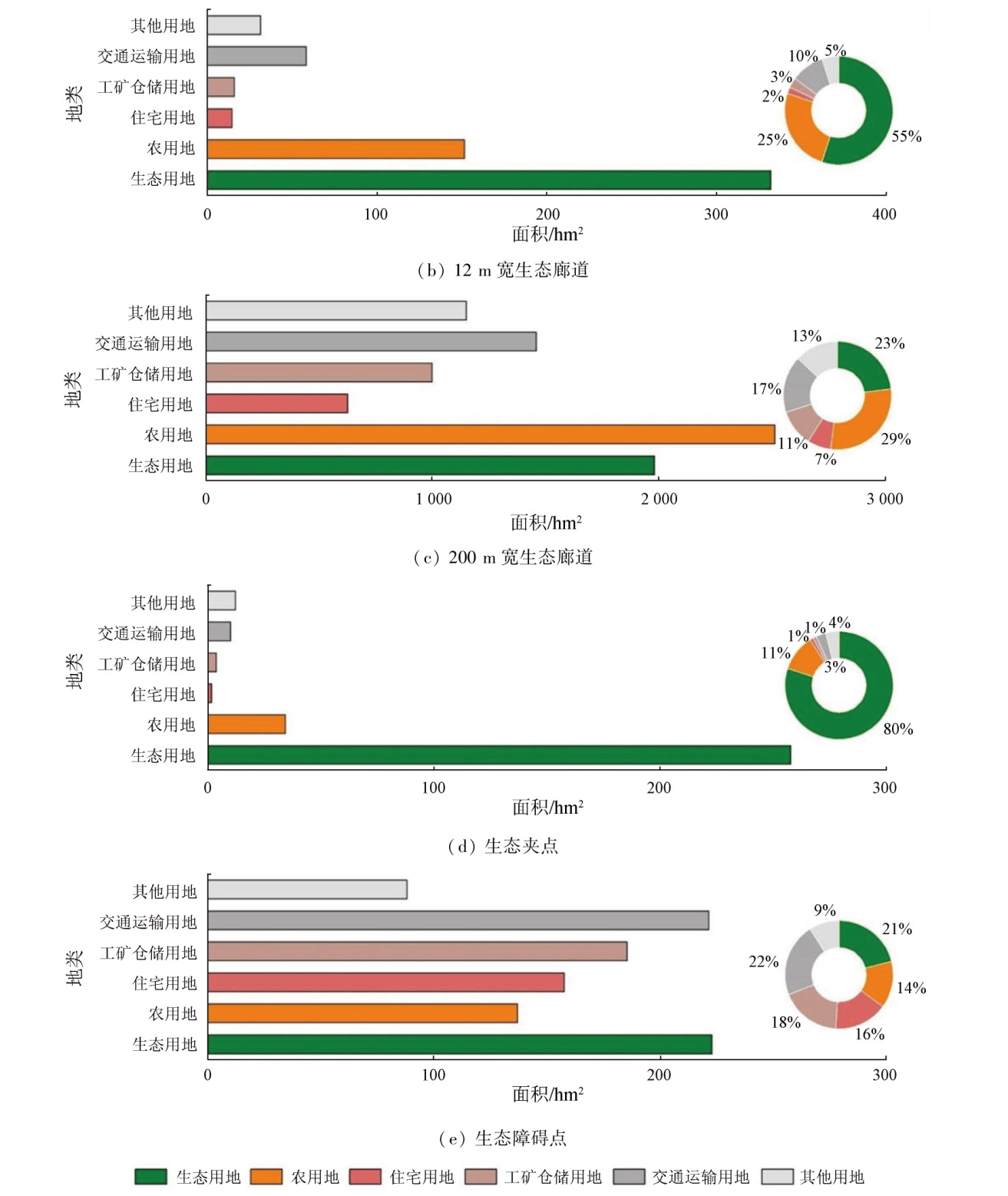
Abstract Constructing ecological security patterns in territorial space can constrain and guide urban spatial development for coordinated and sustainable development of cities and regional environments. Based on the remote sensing ecological index and the minimum cumulative resistance model, this study identified the ecological security pattern factors for Dongguan City, Guangdong Province, including ecological source area, ecological corridor, ecological pinch point, and ecological barrier. Moreover, this study proposed related optimization recommendations. The results of this study indicate that: ① Dongguan City exhibits a favorable ecological base, contiguous ecological spaces, and evenly distributed ecological corridors that can effectively connect ecological source areas; ② Enhanced waterfront space protection and road greening construction provide effective paths for the flow of ecological elements; ③ Agricultural production and transportation manifest the most significant effects on ecological networks, followed by industrial production and domestic life; ④ Ecological sources, 12-m-wide ecological corridors, and ecological pinch points can be classified as key ecological protection areas, while 200-m-wide ecological corridors and ecological barriers can be categorized into key ecological restoration areas. This study will provide a scientific basis for constructing the ecological security pattern in territorial space for Dongguan.
|
| Keywords
ecological source area
ecological corridor
ecological security pattern
territorial space planning
Dongguan City
|
|
|
|
Issue Date: 14 June 2024
|
|
|
| [1] |
吴茂全, 胡蒙蒙, 汪涛, 等. 基于生态安全格局与多尺度景观连通性的城市生态源地识别[J]. 生态学报, 2019, 39(13):4720-4731.
|
| [1] |
Wu M Q, Hu M M, Wang T, et al. Recognition of urban ecological source area based on ecological security pattern and multi-scale landscape connectivity[J]. Acta Ecologica Sinica, 2019, 39(13):4720-4731.
|
| [2] |
苏冲, 董建权, 马志刚, 等. 基于生态安全格局的山水林田湖草生态保护修复优先区识别——以四川省华蓥山区为例[J]. 生态学报, 2019, 39(23):8948-8956.
|
| [2] |
Su C, Dong J Q, Ma Z G, et al. Identifying priority areas for ecological protection and restoration of mountains-rivers-forests-farmlands-lakes-grasslands based on ecological security patterns:A case study in Huaying Mountain,Sichuan Province[J]. Acta Ecologica Sinica, 2019, 39(23):8948-8956.
|
| [3] |
吴健生, 张理卿, 彭建, 等. 深圳市景观生态安全格局源地综合识别[J]. 生态学报, 2013, 33(13):4125-4133.
|
| [3] |
Wu J S, Zhang L Q, Peng J, et al. The integrated recognition of the source area of the urban ecological security pattern in Shenzhen[J]. Acta Ecologica Sinica, 2013, 33(13):4125-4133.
|
| [4] |
彭建, 郭小楠, 胡熠娜, 等. 基于地质灾害敏感性的山地生态安全格局构建——以云南省玉溪市为例[J]. 应用生态学报, 2017, 28(2):627-635.
doi: 10.13287/j.1001-9332.201702.013
|
| [4] |
Peng J, Guo X N, Hu Y N, et al. Constructing ecological security patterns in mountain areas based on geological disaster sensitivity:A case study in Yuxi City,Yunnan Province,China[J]. Chinese Journal of Applied Ecology, 2017, 28(2):627-635.
|
| [5] |
朱灵茜, 李卫正, 乌日汗. 城市生态网络中生态源的界定[J]. 园林, 2017(9):20-23.
|
| [5] |
Zhu L Q, Li W Z, Wu R H. Definition of ecological source in urban ecological network[J]. Garden, 2017(9):20-23.
|
| [6] |
吴静, 黎仁杰, 程朋根. 城市生态源地识别与生态廊道构建[J]. 测绘科学, 2022, 47(4):175-180.
|
| [6] |
Wu J, Li R J, Cheng P G. City ecological source recognition and ecological corridor construction[J]. Science of Surveying and Mapping, 2022, 47(4):175-180.
|
| [7] |
邓金杰, 陈柳新, 杨成韫, 等. 高度城市化地区生态廊道重要性评价探索——以深圳为例[J]. 地理研究, 2017, 36(3):573-582.
doi: 10.11821/dlyj201703014
|
| [7] |
Deng J J, Chen L X, Yang C Y, et al. Significance evaluation of ecological corridor in an highly-urbanized areas:A case study of Shenzhen[J]. Geographical Research, 2017, 36(3):573-582
|
| [8] |
张佳盈, 单丽丽. 构建城市生态网络的必要性与可行性分析[J]. 绿色科技, 2014(2):14-17.
|
| [8] |
Zhang J Y, Shan L L. Necessity and feasibility analysis of constructing urban ecological network[J]. Journal of Green Science and Technology, 2014(2):14-17.
|
| [9] |
骆泓鉴, 明冬萍, 徐录. 基于GEE的遥感生态指数时序计算[J]. 自然资源遥感, 2022, 34(2):271-277.doi:10.6046/zrzyyg.2021150.
|
| [9] |
Luo H J, Ming D P, Xu L. Time series calculation of remote sensing ecological index based on GEE[J]. Remote Sensing for Natural Resources, 2022, 34(2):271-277.doi:10.6046/zrzyyg.2021150.
|
| [10] |
左璐, 孙雷刚, 鲁军景, 等. 基于MODIS的京津冀地区生态质量综合评价及其时空变化监测[J]. 自然资源遥感, 2022, 34(2):203-214.doi:10.6046/zrzyyg.2021224.
|
| [10] |
Zuo L, Sun L G, Lu J J, et al. MODIS-based comprehensive assessment and spatial-temporal change monitoring of ecological quality in Beijing-Tianjin-Hebei region[J]. Remote Sensing for Natural Resources, 2022, 34(2):203-214.doi:10.6046/zrzyyg.2021224.
|
| [11] |
陈行, 刘汉湖, 李金豪, 等. 基于夜光遥感的城市化与生态环境耦合协调分析[J]. 自然资源遥感, 2022, 34(4):280-285.doi:10.6046/zrzyyg.2021369.
|
| [11] |
Chen X, Liu H H, Li J H, et al. Coupling coordination analysis of urbanization and ecological environment based on nighttime light remote sensing[J]. Remote Sensing for Natural Resources, 2022, 34(4):280-285.doi:10.6046/zrzyyg.2021369.
|
| [12] |
宋奇, 冯春晖, 马自强, 等. 基于1990—2019年Landsat影像的干旱区绿洲土地利用变化与模拟[J]. 自然资源遥感, 2022, 34(1):198-209.doi:10.6046/zrzyyg.2021042.
|
| [12] |
Song Q, Feng C H, Ma Z Q, et al. Simulation of land use change in oasis of arid areas based on Landsat images from 1990 to 2019[J]. Remote Sensing for Natural Resources, 2022, 34(1):198-209.doi:10.6046/zrzyyg.2021042.
|
| [13] |
李益敏, 杨舒婷, 吴博闻, 等. 昆明市呈贡区不透水面时空变化及驱动力分析[J]. 自然资源遥感, 2022, 34(2):136-143.doi:10.6046/zrzyyg.2020187.
|
| [13] |
Li Y M, Yang S T, Wu B W, et al. Spatiotemporal evolution of impervious surface and the driving factors in Chenggong District,Kunming City[J]. Remote Sensing for Natural Resources, 2022, 34(2):136-143.doi:10.6046/zrzyyg.2020187.
|
| [14] |
应奎, 李旭东, 程东亚. 岩溶槽谷流域生态环境质量的遥感评定.国土资源遥感[J], 2020, 32(3):173-182.doi:10.6046/gtzyyg.2020.03.23.
|
| [14] |
Ying K, Li X D, Cheng D Y. Remote sensing assessment of ecological environment quality in karst trough basin[J]. Remote Sensing for Land and Resources, 2020, 32(3):173-182.doi:10.6046/gtzyyg.2020.03.23.
|
| [15] |
张秦瑞, 赵良军, 林国军, 等. 改进遥感生态指数的宜宾市三江汇合区生态环境评价[J]. 自然资源遥感, 2022, 34(1):230-237.doi:10.6046/zrzyyg.2021058.
|
| [15] |
Zhang Q R, Zhao L J, Lin G J, et al. Ecological environment assessment of three-river confluence in Yibin City using improved remote sensing ecological index[J]. Remote Sensing for Natural Resources, 2022, 34(1):230-237.doi:10.6046/zrzyyg.2021058.
|
| [16] |
徐涵秋, 王美雅. 地表不透水面信息遥感的主要方法分析[J]. 遥感学报, 2016, 20(5):1270-1289.
|
| [16] |
Xu H Q, Wang M Y. Remote sensing-based retrieval of ground impervious surfaces[J]. Journal of Remote Sensing, 2016, 20(5):1270-1289.
|
| [17] |
王驷鹞, 赵春雷, 陈霞, 等. 基于遥感的唐山市绿色空间演化及对热岛效应的影响[J]. 自然资源遥感, 2022, 34(2):168-175.doi:10.6046/zrzyyg.2021198.
|
| [17] |
Wang S Y, Zhao C L, Chen X, et al. Remote sensing-based green space evolution in Tangshan and its influence on heat island effect[J]. Remote Sensing for Natural Resources, 2022, 34(2):168-175.doi:10.6046/zrzyyg.2021198.
|
| [18] |
王美雅, 徐涵秋. 中外超大城市热岛效应变化对比研究[J]. 自然资源遥感, 2021, 33(4):200-208.doi:10.6046/zrzyyg.2020393.
|
| [18] |
Wang M Y, Xu H Q. A comparative study on the changes in heat island effect in Chinese and foreign megacities[J]. Remote Sensing for Natural Resources, 2021, 33(4):200-208.doi:10.6046/zrzyyg.2020393.
|
| [19] |
Knaapen J P, Scheffer M, Harms B. Estimating habitat isolation in landscape planning[J]. Landscape and Urban Planning, 1992, 23(1):1-16.
|
| [20] |
杨凯, 曹银贵, 冯喆, 等. 基于最小累积阻力模型的生态安全格局构建研究进展[J]. 生态与农村环境学报, 2021, 37(5):555-565.
|
| [20] |
Yang K, Cao Y G, Feng Z, et al. Research progress of ecological security pattern construction based on minimum cumulative resistance model[J]. Journal of Ecology and Rural Environment, 2021, 37(5):555-565.
|
| [21] |
Cui X F, Deng W, Yang J X, et al. Construction and optimization of ecological security patterns based on social equity perspective:A case study in Wuhan,China[J]. Ecological Indicators, 2022, 136:108714.
|
| [22] |
后雪峰, 屈清, 江英志. 基于GIS的揭阳市城市生态安全格局构建[J]. 华南师范大学学报: 自然科学版, 2021, 53(3):83-92.
|
| [22] |
Hou X F, Qu Q, Jiang Y Z. Establishing the ecological security pattern of Jieyang City with GIS[J]. Journal of South China Normal University(Natural Science Edition), 2021, 53(3):83-92.
|
| [23] |
刘壮壮, 吴未, 刘文锋, 等. 基于“源地-廊道”生态安全格局构建逻辑范式的建设用地减量化研究[J]. 生态学报, 2020, 40(22):8230-8238.
|
| [23] |
Liu Z Z, Wu W, Liu W F, et al. Study on construction land reduction based on “Source-Corridor” ecological security pattern paradigm[J]. Acta Ecologica Sinica, 2020, 40(22):8230-8238.
|
| [24] |
袁媛, 白中科, 师学义, 等. 基于生态安全格局的国土空间生态保护修复优先区确定——以河北省遵化市为例[J]. 生态学杂志, 2022, 41(4):750-759.
|
| [24] |
Yuan Y, Bai Z K, Shi X Y, et al. Determining priority areas for ecosystem preservation and restoration of territory based on ecological security pattern:A case study in Zunhua City,Hebei Province[J]. Chinese Journal of Ecology, 2022, 41(4):750-759.
|
| [25] |
倪庆琳, 丁忠义, 侯湖平, 等. 基于电路理论的生态格局识别与保护研究——以宁武县为例[J]. 干旱区资源与环境, 2019, 33(5):67-73.
|
| [25] |
Ni Q P, Ding Z Y, Hou H P, et al. Ecological pattern recognition and protection based on circuit theory[J]. Journal of Arid Land Resources and Environment, 2019, 33(5):67-73.
|
| [26] |
McRae B H, Hall S A, Beier P, et al. Where to restore ecological connectivity? Detecting barriers and quantifying restoration benefits[J]. PLoS One, 2012, 7(12):e52604.
|
| [27] |
朱强, 俞孔坚, 李迪华. 景观规划中的生态廊道宽度[J]. 生态学报, 2005, 25(9):2406-2412.
|
| [27] |
Zhu Q, Yu K J, Li D H. The width of ecological corridor in landscape planning[J]. Acta Ecologica Sinica, 2005, 25(9):2406-2412.
|
|
Viewed |
|
|
|
Full text
|
|
|
|
|
Abstract
|
|
|
|
|
Cited |
|
|
|
|
| |
Shared |
|
|
|
|
| |
Discussed |
|
|
|
|
 2024,
Vol. 36
2024,
Vol. 36
 ), GAO Yizhong, CHEN Minghui(