|
|
 |
|

|
|
|
Application of integrated remote sensing monitoring technology for geological hazards in major engineering construction:A case study of the Yanqing competition area of the Beijing 2022 Olympic Winter Games |
MA Xiaoxue( ), JIAO Runcheng(), CAO Ying, NAN Yun, WANG Shengyu, GUO Xuefei, ZHAO Danning, YAN Chi, NI Xuan ), JIAO Runcheng(), CAO Ying, NAN Yun, WANG Shengyu, GUO Xuefei, ZHAO Danning, YAN Chi, NI Xuan |
| Beijing Institute of Geological Hazard Prevention,Beijing 100120, China |
|
|
|
|
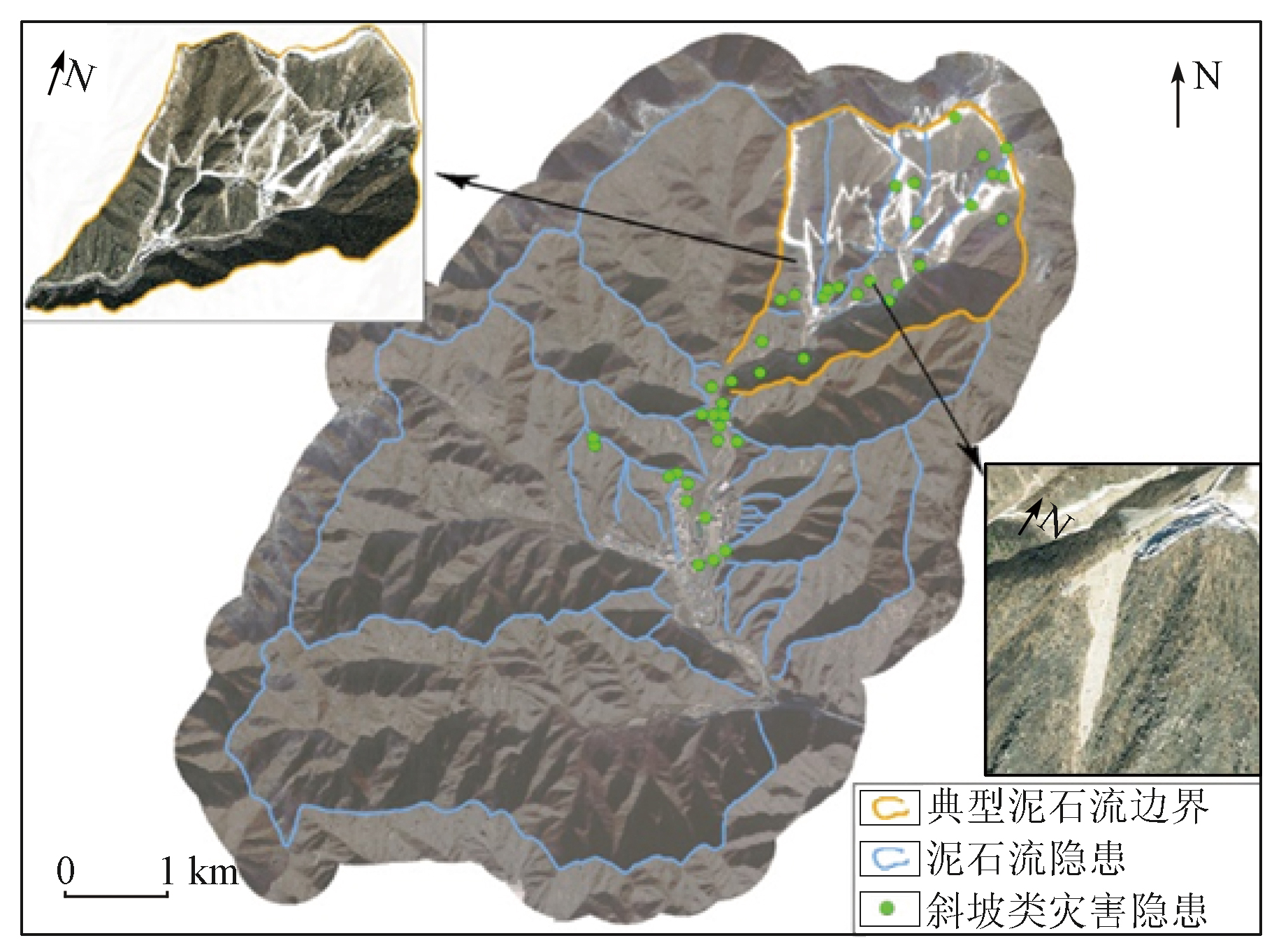
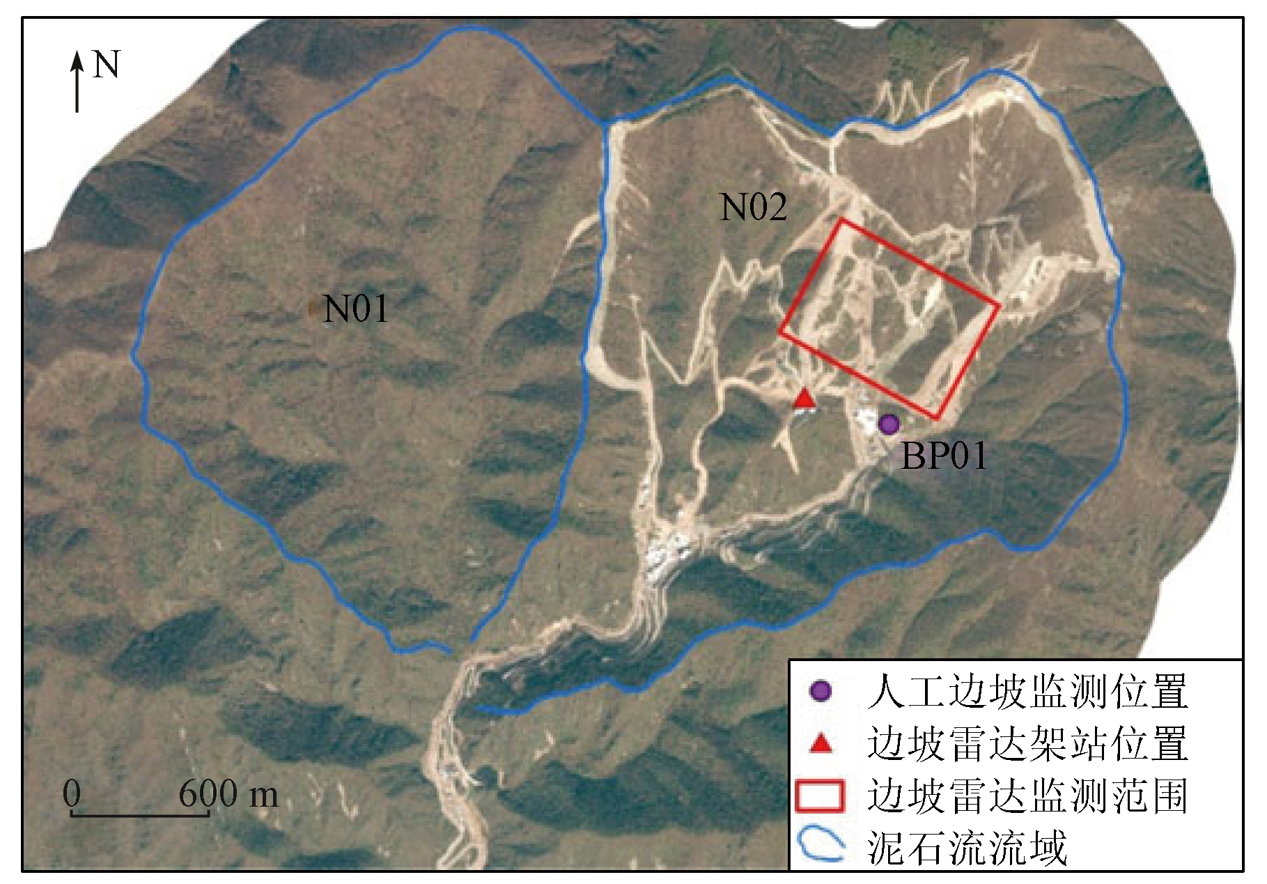
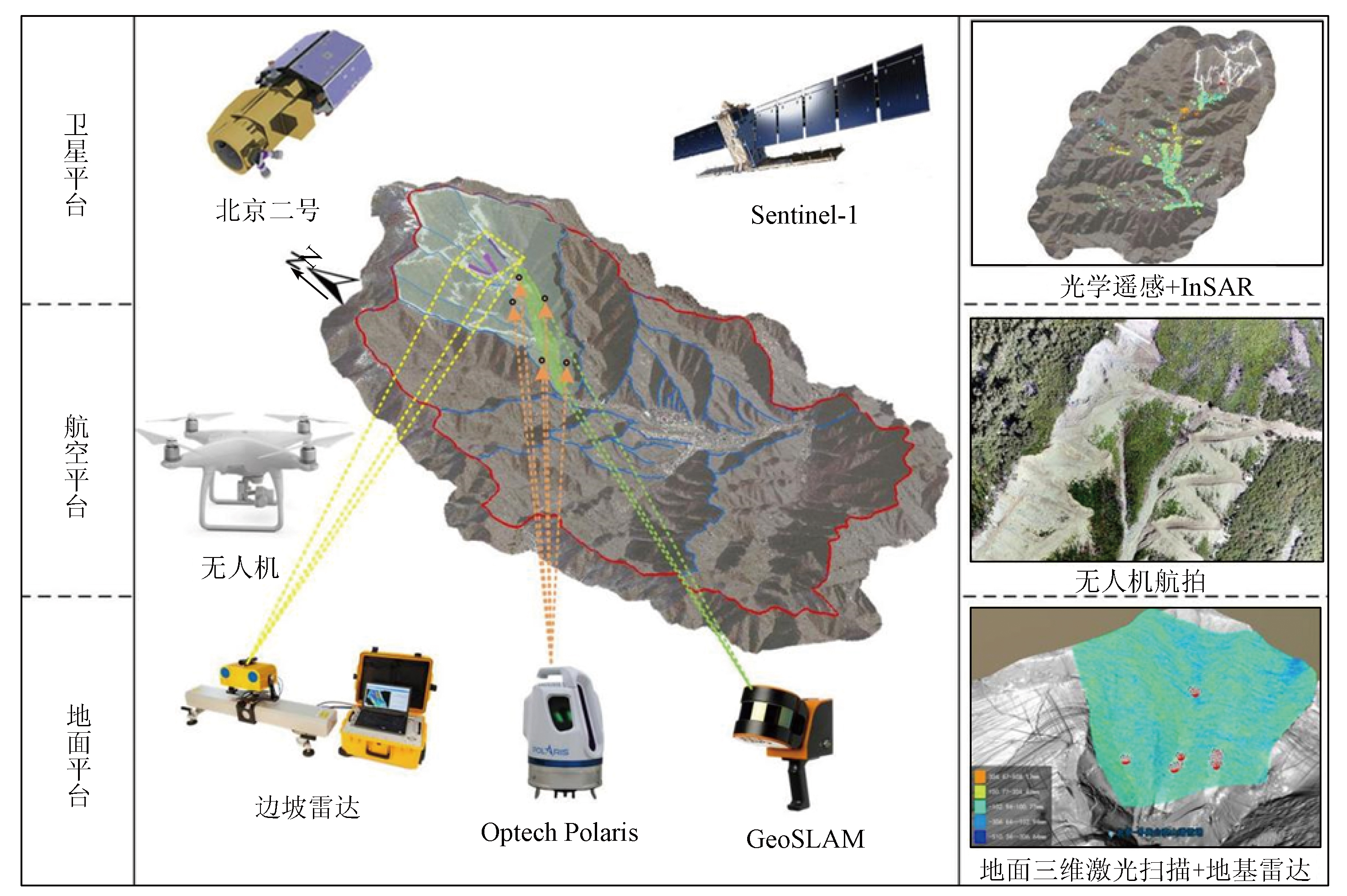
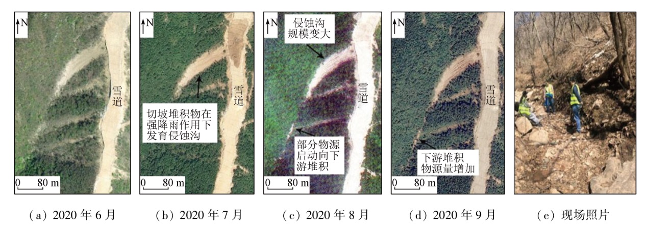
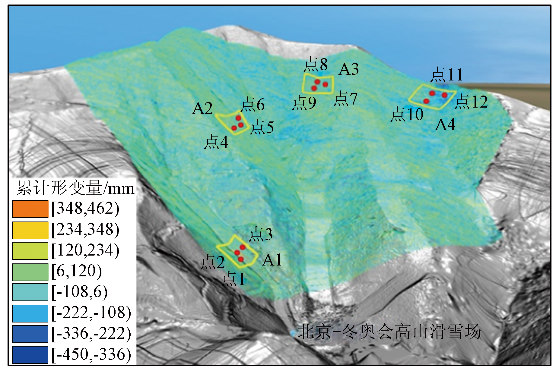
Abstract With the economic and social advancement in China, engineering construction has become a primary cause of geologic hazards. The space-air-ground integrated remote sensing monitoring technology can achieve three-dimensional monitoring at different scales, thus providing rich monitoring methods for geological hazards in major engineering construction. Based on the technology, this study investigated the Yanqing competition area of the Beijing 2022 Olympic Winter Games. Considering the various types of geological hazards in the Yanqing competition area, this study conducted dynamic monitoring of geological hazards in the area by integrating high-resolution optical remote sensing, time-series interferometric synthetic aperture radar (InSAR), unmanned aerial vehicle (UAV) photogrammetry, light detection and ranging (LiDAR), and ground-based InSAR. The dynamic monitoring results reveal the sedimentary source variations in the debris flow gully as well as the deformation zones and time-series deformation characteristics of engineering slopes and ski tracks. This study summarized the integrated remote sensing monitoring methods for geological hazards in major engineering construction, proposing an application assumption of multi-means, multi-platform, multi-disaster, and whole-process hazard monitoring.
|
| Keywords
integrated remote sensing monitoring
Yanqing competition area of Olympic Winter Games
space-air-ground integration
geologic hazard
|
|
|
|
Issue Date: 14 June 2024
|
|
|
| [1] |
刘传正. 中国崩塌滑坡泥石流灾害成因类型[J]. 地质论评, 2014, 60(4):858-868.
|
| [1] |
Liu C Z. Genetic types of landslide and debris flow disasters in China[J]. Geological Review, 2014, 60(4):858-868.
|
| [2] |
任幼蓉. 论三峡库区地质灾害防治工程综合效益[J]. 地质灾害与环境保护, 2002, 13(2):70-74.
|
| [2] |
Ren Y R. On the comprehensive beneficial results of the prevention and control engineering for geological hazards in the three-gorge storage area[J]. Journal of Geological Hazards and Environment Preservation, 2002, 13(2):70-74.
|
| [3] |
任松, 姜德义, 蒋再文, 等. 三峡库区地质灾害监测技术及展望[J]. 中国安全科学学报, 2006(1) :140-144,4.
|
| [3] |
Ren S, Jiang D Y, Jiang Z W, et al. Monitoring technology of geological disaster in Three Gorges Reservoir area and its prospect[J]. China Safety Science Journal, 2006(1):140-144,4.
|
| [4] |
李益陈. 库水作用下三峡库区涪陵段滑坡稳定性研究[D]. 成都: 成都理工大学, 2016.
|
| [4] |
Li Y C. Stability of landslide under the effect of reservoir water in the area of Fuling of the Three Gorges Reservoir area[D]. Chengdu: Chengdu University of Technology, 2016.
|
| [5] |
宋英旭, 邹昱嘉, 叶润青, 等. 利用GEE云平台实现三峡库区滑坡危险性动态分析[J]. 自然资源遥感, 2024, 36(1):154-161.doi:10.6046/zrzyyg.2022464.
|
| [5] |
Song Y X, Zou Y J, Ye R Q, et al. Dynamic analysis of landslide hazards in the Three Gorges Reservoir area based on Google Earth Engine[J]. Remote Sensing for Natural Resources, 2024, 36(1):154-161.doi:10.6046/zrzyyg.2022464.
|
| [6] |
杨海平, 王金生. 长江三峡工程库区千将坪滑坡地质特征及成因分析[J]. 工程地质学报, 2009, 17(2):233-239.
|
| [6] |
Yang H P, Wang J S. Geological features and cause analysis of Qianjiangping landslide of July 13,2003 on Three Gorges Reservoir[J]. Journal of Engineering Geology, 2009, 17(2):233-239.
|
| [7] |
李廷强, 唐军, 唐定洪, 等. 四川丹巴县特大型滑坡形成原因及稳定性分析[J]. 中国地质灾害与防治学报, 2007, 18(3):16-18,24.
|
| [7] |
Li T Q, Tang J, Tang D H, et al. The anslysis on causative factors and stability of a huge landslide in Danba County,Sichuan Province[J]. The Chinese Journal of Geological Hazard and Control, 2007, 18(3):16-18,24.
|
| [8] |
殷跃平, 李廷强, 唐军. 四川省丹巴县城滑坡失稳及应急加固研究[J]. 岩石力学与工程学报, 2008 (5):971-978.
|
| [8] |
Yin Y P, Li T Q, Tang J. Landslide reactivation and emergency stabilization on Danba County town in Sichuan Province[J]. Chinese Journal of Rock Mechanics and Engineering, 2008 (5):971-978.
|
| [9] |
许强, 黄润秋, 殷跃平, 等. 2009年6·5重庆武隆鸡尾山崩滑灾害基本特征与成因机理初步研究[J]. 工程地质学报, 2009, 17(4):433-444.
|
| [9] |
Xu Q, Huang R Q, Yin Y P,et.al. The Jiweishan landslide of June 5,2009 in Wulong,Chongqing:Characteristics and failure mechanism[J]. Journal of Engineering Geology, 2009, 17(4):433-444.
|
| [10] |
许强. 构建新“三查”体系,创新地灾防治新机制[N]. 中国矿业报,2018-03-12.
|
| [10] |
Xu Q. Constructing a new“Three-Check”System,innovating new mechanisms for disaster prevention and control[N]. China Mining Newspaper,2018-03-12.
|
| [11] |
许强, 董秀军, 李为乐. 基于天-空-地一体化的重大地质灾害隐患早期识别与监测预警[J]. 武汉大学学报(信息科学版), 2019, 44(7):957-966.
|
| [11] |
Xu Q, Dong X J, Li W L. Integrated space-air-ground early detection,monitoring and warning system for potential catastrophic geohazards[J]. Geomatics and Information Science of Wuhan University, 2019, 44(7):957-966.
|
| [12] |
许强. 对地质灾害隐患早期识别相关问题的认识与思考[J]. 武汉大学学报(信息科学版), 2020, 45(11):1651-1659.
|
| [12] |
Xu Q. Understanding and consideration of related issues in early identification of potential geohazards[J]. Geomatics and Information Science of Wuhan University, 2020, 45(11):1651-1659.
|
| [13] |
许强, 陆会燕, 李为乐, 等. 滑坡隐患类型与对应识别方法[J]. 武汉大学学报(信息科学版), 2022, 47(3):377-387.
|
| [13] |
Xu Q, Lu H Y, Li W L, et al. Types of potential landslide and corresponding identification technologies[J]. Geomatics and Information Science of Wuhan University, 2022, 47(3):377-387.
|
| [14] |
葛大庆. 地质灾害早期识别与监测预警中的综合遥感应用[J]. 城市与减灾, 2018(6):53-60.
|
| [14] |
Ge D Q. Comprehensive application of remote sensing in early identification,monitoring and early warning in geological disasters[J]. City and Disaster Reduction, 2018(6):53-60.
|
| [15] |
葛大庆, 戴可人, 郭兆成, 等. 重大地质灾害隐患早期识别中综合遥感应用的思考与建议[J]. 武汉大学学报(信息科学版), 2019, 44(7):949-956.
|
| [15] |
Ge D Q, Dai K R, Guo Z C, et al. Early identification of serious geological hazards with integrated remote sensing technologies:Thoughts and recommendations[J]. Geomatics and Information Science of Wuhan University, 2019, 44(7):949-956.
|
| [16] |
陆会燕, 李为乐, 许强, 等. 光学遥感与InSAR结合的金沙江白格滑坡上下游滑坡隐患早期识别[J]. 武汉大学学报(信息科学), 2019, 44(9):1342-1354.
|
| [16] |
Lu H Y, Li W L, Xu Q, et al. Early detection of landslides in the upstream and downstream areas of the baige landslide,the Jinsha River based on optical remote sensing and InSAR technologies[J]. Geomatics and Information Science of Wuhan University, 2019, 44(9):1342-1354.
|
| [17] |
焦润成, 郭学飞, 南赟, 等. 采空区-滑坡-泥石流链式灾害隐患综合遥感识别与评价[J]. 金属矿山, 2023(1):73-82.
|
| [17] |
Jiao R C, Guo X F, Nan Y, et al. Comprehensive remote sensing technology for goaf-landslide-debris flow disaster chain identification and evaluation[J]. Metal Mine, 2023(1):73-82.
|
| [18] |
Fruneau B, Achache J, Delacourt C. Observation and modelling of the Saint-Étienne-de-Tinée landslide using SAR interferometry[J]. Tectonophysics, 1996, 265(3-4):181-190.
|
| [19] |
Baek W K, Jung H S. Precise three-dimensional deformation retrieval in large and complex deformation areas via integration of offset-based unwrapping and improved multiple-aperture SAR interferometry:Application to the 2016 Kumamoto earthquake[J]. Engineering, 2020, 6(8):927-935.
|
| [20] |
Shi X, Yang C, Zhang L, et al. Mapping and characterizing displacements of active loess slopes along the upstream Yellow River with multi-temporal InSAR datasets[J]. Science of the Total Environment, 2019, 674:200-210.
|
| [21] |
Yao J, Lan H, Li L, et al. Characteristics of a rapid landsliding area along Jinsha River revealed by multi-temporal remote sensing and its risks to Sichuan-Tibet Railway[J]. Landslides, 2022, 19(3):703-718.
|
| [22] |
Jiao R, Wang S, Yang H, et al. Comprehensive remote sensing technology for monitoring landslide hazards and disaster chain in the Xishan mining area of Beijing[J]. Remote Sensing, 2022, 14:4695.
|
| [23] |
闫驰, 焦润成, 曹颖, 等. 无人机倾斜摄影在泥石流灾害识别分析中的应用——以北京房山区史家营曹家坊泥石流为例[J]. 国土资源遥感, 2020, 32(4):251-257.doi:10.6046/gtzyyg.2020.04.31.
|
| [23] |
Yan C, Jiao R C, Cao Y, et al. The application of UAV oblique photography in debris flow disaster identification and analysis:Taking the debris flow in Caojiafang,Shijiaying,Fangshan District,Beijing as an Example[J]. Remote Sensing for Land and Resources, 2020, 32(4):251-257.doi:10.6046/gtzyyg.2020.04.31.
|
| [24] |
郭学飞, 焦润成, 曹颖, 等. 倾斜摄影测量技术在崩塌隐患调查评价中的应用[J]. 中国地质灾害与防治学报, 2020, 31(1):65-69.
|
| [24] |
Guo X F, Jiao R C, Cao Y, et al. Application of oblique photography in the investigation potential of rockfall[J]. The Chinese Journal of Geological Hazard and Control, 2020, 31(1):65-69.
|
| [25] |
Liu X, Lian X, Yang W, et al. Accuracy assessment of a UAV direct georeferencing method and impact of the configuration of ground control points[J]. Drones, 2022, 6(2):30-44.
|
| [26] |
Zhang Y, Lian X, Ge L, et al. Surface subsidence monitoring induced by underground coal mining by combining DInSAR and UAV photogrammetry[J]. Remote Sensing, 2022, 14(19):4711-4724.
|
| [27] |
Gorsevski P V. An evolutionary approach for spatial prediction of landslide susceptibility using LiDAR and symbolic classification with genetic programming[J]. Natural Hazards, 2021, 108:2283-2307.
|
| [28] |
刘宇平, 梁虹, 陈菲菲. 高精度机载LiDAR在小江活动构造和地质灾害研究中的应用[J]. 地质力学学报, 2016, 22(3):747-759.
|
| [28] |
Liu Y P, Liang H, Chen F F. Application of high resolution airborne LiDAR in Xiaojiang active tectonics and geological disaster study[J]. Journal of Geomechanics, 2016, 22(3):747-759.
|
| [29] |
贾虎军, 王立娟, 范冬丽. 无人机载LiDAR和倾斜摄影技术在地质灾害隐患早期识别中的应用[J]. 中国地质灾害与防治学报, 2021, 32(2):60-65.
|
| [29] |
Jia H J, Wang L J, Fan D L. The application of UAV LiDAR and tilt photography in the early identification of geo-hazards[J]. The Chinese Journal of Geological Hazard and Control, 2021, 32(2):60-65.
|
| [30] |
杨晓琳, 马海涛, 乞耀龙, 等. 边坡安全监测技术新发展——中国安科院边坡雷达“S-SAR”诞生记[J]. 劳动保护, 2015(5):96-99.
|
| [30] |
Yang X L, Ma H T, Qi Y L, et al. New development of slope safety monitoring technology:Birth of slope Radar “S-SAR” Chinese Academy of Security Sciences[J]. Labour Protection, 2015(5):96-99.
|
| [31] |
赵东寅, 申其鸿, 马海涛, 等. 国产地基合成孔径雷达监测预警系统在紫金山金铜矿露天采场边坡位移监测的应用[J]. 中国安全生产科学技术, 2015, 11(4):54-58.
|
| [31] |
Zhao D Y, Shen Q H, Ma H T, et al. Application of domestic ground based synthetic aperture Radar monitoring and warning system in slope displacement monitoring on open pit of Zijinshan gold/copper mine[J]. Journal of Safety Science and Technology, 2015, 11(4):54-58.
|
| [32] |
Han J, Yang H, Liu Y, et al. A deep learning application for deformation prediction from ground-based InSAR[J]. Remote Sensing, 2022, 14,5067.
|
| [33] |
林德才, 马海涛, 宋宝宏. 边坡雷达在滑坡应急救援行动中的应用[J]. 中国安全生产科学技术, 2016, 12(s1):284-289.
|
| [33] |
Lin D C, Ma H T, Song B H. Application of slope Radar in landslide emergency rescue operation[J]. Journal of Safety Science and Technology, 2016, 12(s1):284-289.
|
| [34] |
陈洁, 蔡君, 李京, 等. 倾斜航空摄影技术及在地质调查中的应用研究——以三峡库区巫峡地区为例[J]. 国土资源遥感, 2021, 33(1):167-173.doi:10.6046/gtzyyg.2020133.
|
| [34] |
Chen J, Cai J, Li J, et al. Oblique aerial photography technology and its application to geological survey:A case study of Wuxia section in the Three Gorges Reservoir[J]. Remote Sensing for Land and Resources, 2021, 33(1):167-173.doi:10.6046/gtzyyg.2020133.
|
| [35] |
黄海峰, 薛蓉花, 赵蓓蓓, 等. 孕灾机理与综合遥感结合的三峡库首顺层岩质滑坡隐患识别[J]. 测绘学报, 2022, 51(10):2056-2068.
doi: 10.11947/j.AGCS.2022.20220306
|
| [35] |
Huang H F, Xue R H, Zhao B B, et al. The bedding rock landslide identification in the head area of the Three Gorges Reservoir combined with disaster pregnant mechanism and comprehensive remote sensing method[J]. Acta Geodaetica et Cartographica Sinica, 2022, 51,(10):2056-2068.
doi: 10.11947/j.AGCS.2022.20220306
|
| [36] |
北京2022年冬奥会延庆赛区地质危险性现状评估报告[R]. 北京: 北京市地质调查研究院、北京市地质研究所, 2020.
|
| [36] |
Assessment report on geological hazards in Yanqing competition area of Beijing 2022 Winter Olympic Games[R], Beijing: Beijing Institute of Geological Survey,Beijing Institute of Geological Hazard Prevention, 2020.
|
|
Viewed |
|
|
|
Full text
|
|
|
|
|
Abstract
|
|
|
|
|
Cited |
|
|
|
|
| |
Shared |
|
|
|
|
| |
Discussed |
|
|
|
|
 2024,
Vol. 36
2024,
Vol. 36