|
|
|
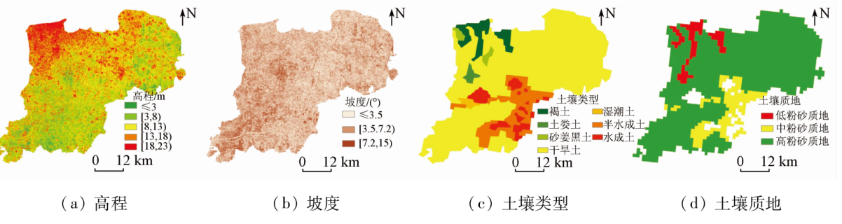
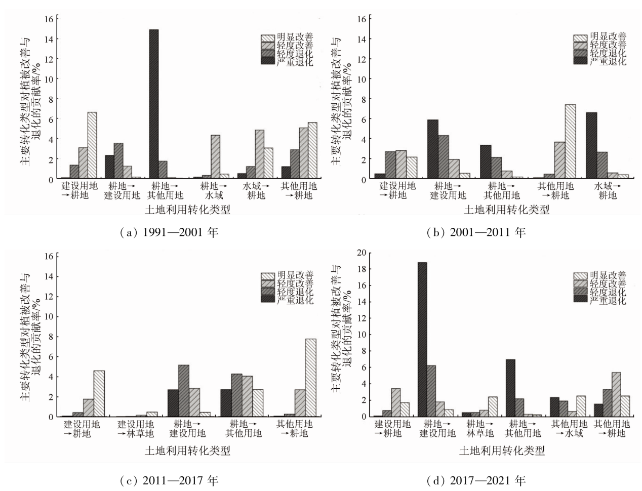
Abstract This study aims to analyze the changes in the land use and vegetation cover in the Xiong'an New Area from 1991 to 2021. To this end, this study explored the characteristics of the land use changes in the area over the 30 years based on the Landsat TM\OLI data of five periods using the GIS technology and map fusion method. Then, it extracted the vegetation cover information using the dimidiate pixel model and analyzed the changes in the vegetation cover. Furthermore, this study explored the potential factors driving the vegetation cover change in the area using the geographic detector model and analyzed the impact of land use change on vegetation cover change by referencing the existing map fusion method. The results show that: ① From 1991 to 2021, the construction land in Xiong’an New Area increased by 108.09 km2, primarily transformed from farmland and other types of land; other types of land reduced by 108.17 km2, predominantly transformed to farmland; forestland and grassland increased by 11.56 km2, mainly transformed from water areas and other types of land; the water area decreased by 38.76 km2, mainly transformed to farmland and other types of land; and the area of farmland roughly remained unchanged; ② Over the 30 years, the Xiong’an New Area generally exhibited high vegetation coverage, and the area with moderate and high vegetation coverage and above accounted for more than 50.00%. The vegetation coverage in the Xiong’an New Area presented an overall spatial distribution pattern characterized by high in Anxin County, moderate in Rongcheng County, and low in Xiong County. Regarding the phased changes, this area showed a degradation trend from 1991 to 2001, and the area with degraded vegetation cover accounted for 39.15%. From 2001 to 2021, this area exhibited an improvement trend, the area with improved vegetation cover accounted for up to 47.55%; ③ The vegetation cover change showed spatial differentiation, significantly affected by the population density, GDP, soil type, and soil quality but slightly affected by the elevation and slope. The transformation of construction land and other types of land to farmland acted as an important reason for the improvement in vegetation cover, while the transformation of farmland to construction land and other types of land served as an important reason for vegetation degradation. The results of this study can, to some extent, provide a scientific basis and suggestions for the sustainable development of Xiong’an New Area.
|
| Keywords
Xiong’an New Area
vegetation cover change
land use change
geographic detector
driving factors
|
|
|
|
Issue Date: 21 December 2023
|
|
|
| [1] |
Sun L, Wei J, Duan D H, et al. Impact of land-use and land-cover change on urban air quality in representative cities of China[J]. Journal of Atmospheric and Solar-Terrestrial Physics, 2016, 142:43-54.
doi: 10.1016/j.jastp.2016.02.022
url: https://linkinghub.elsevier.com/retrieve/pii/S1364682616300542
|
| [2] |
新华社. 中共中央、国务院决定设立河北雄安新区[EB/OL].(2017-04-01) [2017-05-31]. https://www.gov.cn/xinwen/2017-04/01/content5182824htm.
url: https://www.gov.cn/xinwen/2017-04/01/content5182824htm
|
| [2] |
Xin Hua News Agency. The Central Committee of the Communist Party of China and the State Council decided to establish the Xiong’an new area in Hebei[EB/OL].(2017-04-01) [2017-05-31]. https://www.gov.cn/xinwen/2017-04/01/content5182824htm.
url: https://www.gov.cn/xinwen/2017-04/01/content5182824htm
|
| [3] |
吴昌广, 周志翔, 肖文发, 等. 基于MODIS NDVI的三峡库区植被覆盖度动态监测[J]. 林业科学, 2012, 48(1):22-28.
|
| [3] |
Wu C G, Zhou Z X, Xiao W F, et al. Dynamic monitoring of vegetation cover in Three Gorges reservoir area based on MODIS NDVI[J]. Scientia Silvae Sinicae, 2012, 48(1):22-28.
|
| [4] |
刘斌, 罗全华, 常文哲, 等. 不同林草植被覆盖度的水土保持效益及适宜植被覆盖度[J]. 中国水土保持科学, 2008, 6(6):68-73.
|
| [4] |
Liu B, Luo Q H. Chang W Z, et al. Soil and water conservation benefits of different forest and grass vegetation cover levels and suitable vegetation cover levels[J]. Soil and Water Conservation in China, 2008, 6(6):68-73.
|
| [5] |
何全军, 曹静, 张月维. 基于MODIS的广东省植被指数序列构建与应用[J]. 气象, 2008, 34(3):37-41.
|
| [5] |
He Q J, Cao J, Zhang Y W. Construction and application of MODIS based vegetation index series in Guangdong Province[J]. Meteorological Monthly, 2008, 34(3):37-41.
|
| [6] |
彭飞, 范闻捷, 徐希孺, 等. 2000—2014年呼伦贝尔草原植被覆盖度时空变化分析[J]. 北京大学学报(自然科学版), 2017, 53(3):563-572.
|
| [6] |
Peng F, Fan W J, Xu X R, et al. Analysis of spatial and temporal changes of vegetation cover in Hulunbuir grassland from 2000 to 2014[J]. Acta Scientiarum Naturalium Universitatis Pekinensis, 2017, 53(3):563-572.
|
| [7] |
王思, 张路路, 林伟彪, 等. 基于MODIS-NDVI的广东省植被覆盖与土地利用变化研究[J]. 生态学报, 2022(6):2149-2163.
|
| [7] |
Wang S, Zhang L L, Lin W B, et al. Research on vegetation cover and land use change in Guangdong Province based on MODIS-NDVI[J]. Acta Ecologica Sinica, 2022(6):2149-2163.
|
| [8] |
晋成名, 杨兴旺, 景海涛. 基于RS的陕北地区植被覆盖度变化及驱动力研究[J]. 自然资源遥感, 2021, 33(4):258-264.doi:10.6046/zrzyyg.2021019.
|
| [8] |
Jin C M, Yang X W, Jing H T. RS-based study on vegetation cover changes and driving forces in northern Shaanxi[J]. Remote Sensing for Natural Resources, 2021, 33(4):258-264.doi:10.6046/zrzyyg.2021019.
|
| [9] |
苏迎庆, 刘庚, 赵景波, 等. 2006—2018年汾河流域土地生态安全预警测度及时空格局演变[J]. 水土保持通报, 2021, 41(1):144-151.
|
| [9] |
Su Y Q, Liu G, Zhao J B, et al. Evolution of early warning measures and spatial and temporal patterns of land ecological security in the Fen River Basin from 2006-2018[J]. Bulletin of Soil and Water Conservation, 2021, 41(1):144-151.
|
| [10] |
Kallimanis A S, Touloumis K, Tzanopoulos J, et al. Vegetation coverage change in the EU:Patterns inside and outside Natura 2000 protected areas[J]. Biodiversity and Conservation, 2015, 24(3): 579-591.
doi: 10.1007/s10531-014-0837-9
url: http://link.springer.com/10.1007/s10531-014-0837-9
|
| [11] |
Jung G, Prange M, Schulz M. Influence of topography on tropical African vegetation coverage[J]. Climate Dynamics, 2016, 46(7):2535-2549.
doi: 10.1007/s00382-015-2716-9
url: http://link.springer.com/10.1007/s00382-015-2716-9
|
| [12] |
王劲峰, 徐成东. 地理探测器:原理与展望[J]. 地理学报, 2017, 72(1):116-134.
doi: 10.11821/dlxb201701010
|
| [12] |
Wang J F, Xu C D. Geodetectors:Principles and perspectives[J]. Acta Geographica Scinica, 2017, 72(1):116-134.
|
| [13] |
Wang G J, Peng W F. Quantifying spatiotemporal dynamics of vegetation and its differentiation mechanism based on geographical detector[J]. Environmental Science and Pollution Research, 2022, 29(21):32016-32031.
doi: 10.1007/s11356-021-17544-w
|
| [14] |
Deng X J, Hu S Z, Che S. Attribution of vegetation coverage change to climate change and human activities based on the geographic detectors in the Yellow River Basin,China[J]. Environmental Science and Pollution Researchinternational, 2022: 1-16.
|
| [15] |
彭文甫, 张冬梅, 罗艳玫, 等. 自然因子对四川植被NDVI变化的地理探测[J]. 地理学报, 2019, 74(9):1758-1776.
doi: 10.11821/dlxb201909005
|
| [15] |
Peng W F, Zhang D M, Luo Y M, et al. Geographical detection of natural factors on NDVI changes in Sichuan vegetation[J]. Acta Geographica Scinica, 2019, 74(9):1758-1776.
|
| [16] |
李丹, 周嘉, 战大庆. 黑龙江省耕地时空变化及驱动因素分析[J]. 地理科学, 2021, 41(7):1266-1275.
doi: 10.13249/j.cnki.sgs.2021.07.017
|
| [16] |
Li D, Zhou J, Zhan D Q. Analysis of spatial and temporal changes in arable land and drivers in Heilongjiang Province[J]. Scientia Geographica Sinica, 2021, 41(7):1266-1275.
|
| [17] |
祁鹏卫, 张贤. 2000—2019年重庆市植被覆盖时空变化特征及其驱动因素[J]. 生态学报, 2022, 42(13):5427-5436.
|
| [17] |
Qi P W, Zhang X. Analysis of spatial and temporal variation characteristics of vegetation cover and its driving factors in Chongqing from 2000 to 2019[J]. Acta Ecologica Sinica, 2022, 42(13):5427-5436.
|
| [18] |
赵子娟, 范蓓蕾, 王玉庭, 等. 2000—2018年西辽河流域植被覆盖度时空变化特征及影响因素研究[J]. 中国农业资源与区划, 2021, 42(12):75-88.
|
| [18] |
Zhao Z J, Fan B L, Wang Y T, et al. Study on the characteristics of spatial and temporal changes of vegetation cover and influencing factors in the West Liaoning River Basin from 2000 to 2018[J]. Journal of China Agricultural Resources and Regional Planning, 2021, 42(12):75-88.
|
| [19] |
贾玉娜, 张文超, 康会涛, 等. 2016-2019年雄安新区土地覆盖变化研究[J]. 测绘通报, 2020(9):76-79.
doi: 10.13474/j.cnki.11-2246.2020.0287
|
| [19] |
Jia Y N, Zhang W C, Kang H T, et al. A study of land cover changes in Xiongan New Area from 2016 to 2019[J]. Bulletin of Surveying and Mapping, 2020(9):76-79.
|
| [20] |
姜鲁光, 吕佩忆, 封志明, 等. 雄安新区土地利用空间特征及起步区方案比选研究[J]. 资源科学, 2017, 39(6):991-998.
doi: 10.18402/resci.2017.06.01
|
| [20] |
Jiang L G, Lv P Y, Feng Z M, et al. Study on the spatial characteristics of land use in the Xiong’an New Area and the comparison of start-up area options[J]. Resources Science, 2017, 39(6):991-998.
|
| [21] |
孙颖, 易浪, 尹少华. 洞庭湖流域植被覆盖变化及其协同治理[J]. 经济地理, 2022, 42(4):190-201.
|
| [21] |
Sun Y, Yi L, Yin S H. Vegetation cover changes in the Dongting Lake watershed and its synergistic management[J]. Economic Geography, 2022, 42(4):190-201.
|
| [22] |
曹永香, 毛东雷, 薛杰, 等. 绿洲-沙漠过渡带植被覆盖动态变化及其驱动因素——以新疆策勒为例[J]. 干旱区研究, 2022, 39(2):510-521.
|
| [22] |
Cao Y X, Mao D L, Xue J, et al. Vegetation cover dynamics in the oasis-desert transition zone and its driving factors:A case of Cele,Xinjiang[J]. Arid Zone Research, 2022, 39(2):510-521.
|
| [23] |
Sewnet A, Abebe G. Land use and land cover change and implication to watershed degradation by using GIS and remote sensing in the Koga watershed,North Western Ethiopia[J]. Earth science Informatics, 2018, 11(1): 99-108.
doi: 10.1007/s12145-017-0323-5
url: http://link.springer.com/10.1007/s12145-017-0323-5
|
| [24] |
吕晓, 史洋洋, 黄贤金, 等. 江苏省土地利用变化的图谱特征[J]. 应用生态学报, 2016, 27(4):1077-1084.
|
| [24] |
Lyu X, Shi Y Y, Huang X J, et al. Mapping characteristics of land use change in Jiangsu Province[J]. Chinese Journal of Applied Ecology, 2016, 27(4):1077-1084.
|
| [25] |
王金亮, 邵景安, 李阳兵. 近20 a三峡库区农林地利用变化图谱特征分析[J]. 自然资源学报, 2015, 30(2):235-247.
doi: 10.11849/zrzyxb.2015.02.007
|
| [25] |
Wang J L, Shao J A, Li Y B. Characterization of agricultural and forest land use change mapping in the Three Gorges reservoir area in the last 20 a[J]. Journal of Natural Resources, 2015, 30(2):235-247.
|
| [26] |
杨彩云, 王世曦, 杨春艳, 等. 川藏铁路沿线植被覆盖度时空变化特征分析[J]. 干旱区资源与环境, 2021, 35(3):174-182.
|
| [26] |
Yang C Y, Wang S X, Yang C Y, et al. Spatial and temporal variation characteristics of vegetation cover along the Sichuan-Tibet Railway[J]. Journal of Arid Land Resources and Environment, 2021, 35(3):174-182.
|
| [27] |
Mishra R, Singh E, Kumar A. et al. Application of remote sensing for assessment of change in vegetation cover and the subsequent impact on climatic variables[J]. Environmental Science and Pollution Rellution Research, 2021, 28(31):41675-41687.
|
| [28] |
李苗苗, 吴炳方, 颜长珍, 等. 密云水库上游植被覆盖度的遥感估算[J]. 资源科学, 2004, 26(4):153-159.
|
| [28] |
Li M M, Wu B F, Yan C Z, et al. Remote sensing estimation of vegetation cover in the upper reaches of Miyun Reservoir[J]. Resources Science, 2004, 26(4):153-159.
|
| [29] |
王文川, 薛沛, 刘素华. 1999-2018年河南省植被覆盖时空演变分析[J]. 水土保持研究, 2022, 29(2):243-248,264.
|
| [29] |
Wang W C, Xue P, Liu S H. Analysis of spatial and temporal evolution of vegetation cover in Henan Province from 1999 to 2018[J]. Research of Soil and Water Conservation, 2022, 29(2):243-248,264.
|
| [30] |
Gao S Q, Dong G T, Jiang X H, Nie T, et al. Quantification of natural and anthropogenic driving forces of vegetation changes in the Three-River headwater region during 1982 to 2015 based on geographical detector model[J]. Remote Sensing, 2021, 13(20): 4175.
doi: 10.3390/rs13204175
url: https://www.mdpi.com/2072-4292/13/20/4175
|
| [31] |
王正雄, 蒋勇军, 张远嘱, 等. 基于GIS与地理探测器的岩溶槽谷石漠化空间分布及驱动因素分析[J]. 地理学报, 2019, 74(5):1025-1039.
doi: 10.11821/dlxb201905014
|
| [31] |
Wang Z X, Jiang Y J, Zhang Y Z, et al. Analysis of spatial distribution and drivers of rock desertification in karst trough valleys based on GIS and geodetectors[J]. Acta Geographica Scinica, 2019, 74(5):1025-1039.
|
| [32] |
黄木易, 岳文泽, 方斌, 等. 1970—2015年大别山区生态服务价值尺度响应特征及地理探测机制[J]. 地理学报, 2019, 74(9):1904-1920.
doi: 10.11821/dlxb201909015
|
| [32] |
Huang M Y, Yue W Z, Fang B, et al. Characteristics of ecological service value scale response and geodetection mechanism in Dabie Mountain area from 1970 to 2015[J]. Acta Geographica Scinica, 2019, 74(9):1904-1920.
|
|
Viewed |
|
|
|
Full text
|
|
|
|
|
Abstract
|
|
|
|
|
Cited |
|
|
|
|
| |
Shared |
|
|
|
|
| |
Discussed |
|
|
|
|
 2023,
Vol. 35
2023,
Vol. 35
 ), WANG Shidong1, ZHANG Xuejun2(