|
|
 |
|

|
|
|
Analyzing the spatio-temporal evolution of urban expansion in the Central Plains urban agglomeration and its driving force based on DMSP/OLS and NPP/VIIRS nighttime light images |
HU Miaomiao1,2( ), YAN Qingwu2,3(), LI Jianhui1 ), YAN Qingwu2,3(), LI Jianhui1 |
1. Faculty of Surveying and Mapping Engineering, Yellow River Conservancy Technical Institute, Kaifeng 475004, China
2. Jiangsu Key Laboratory of Resources and Environmental Information Engineering, China University of Mining and Technology, Xuzhou 221116, China
3. School of Public Policy & Management, China University of Mining and Technology, Xuzhou 221116, China |
|
|
|
|
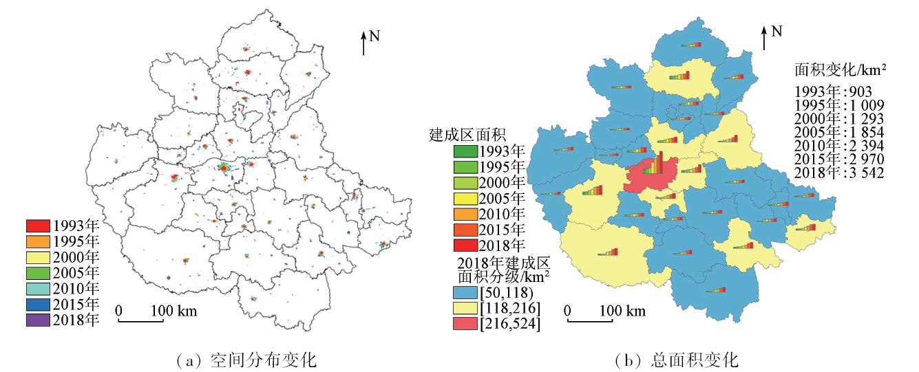
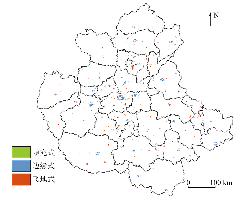
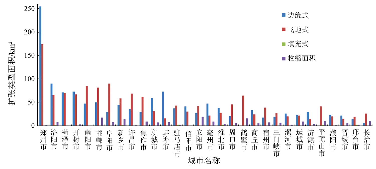
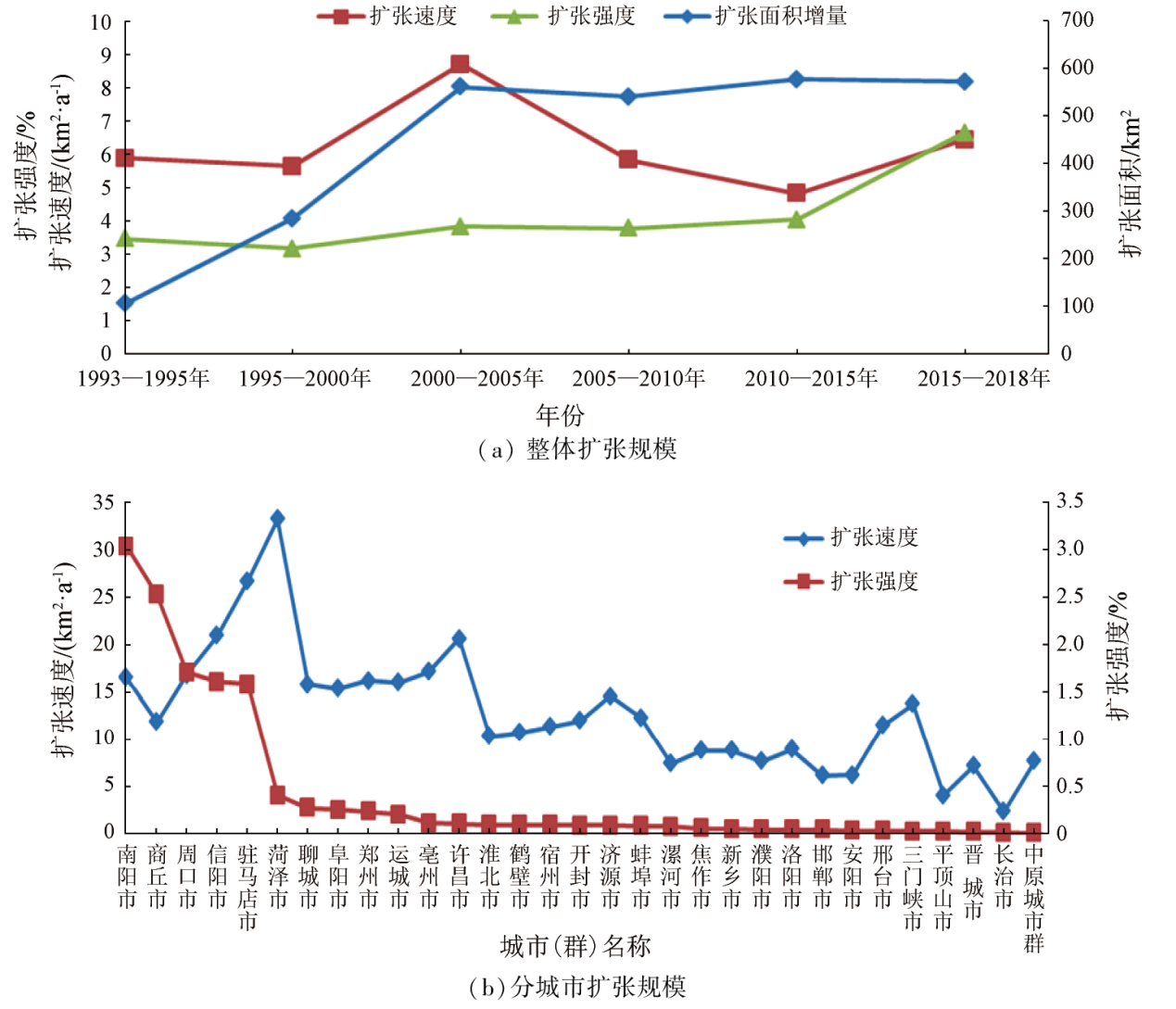
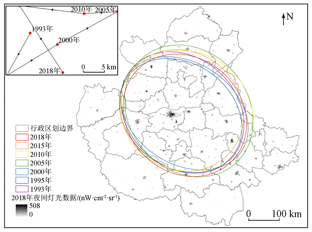
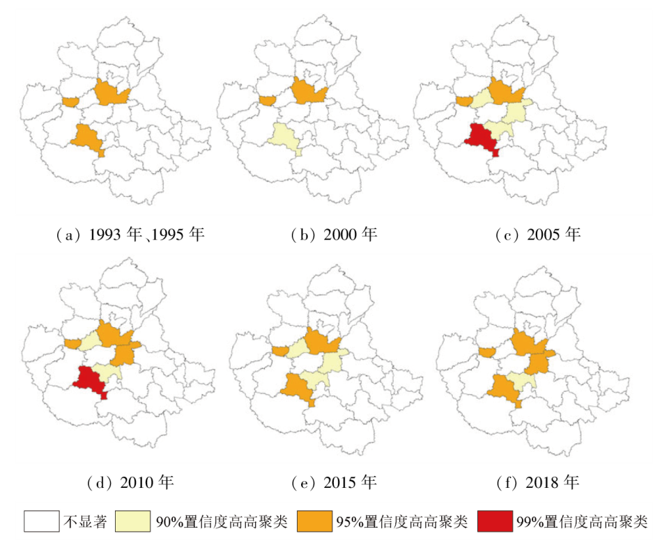
Abstract Discerning the spatial pattern and driving mechanism of urban expansion will contribute to the sustainable development of the Central Plains urban agglomeration (CPUA). Based on the DMSP/OLS and NPP/VIIRS nighttime light images, this study extracted the built-up area of the CPUA from 1993 to 2018 through statistical data comparison. Furthermore, this study delved into the spatial-temporal evolutionary characteristics of the urban expansion in this period on scales of the entire urban agglomeration and prefecture-level cities. Accordingly, this study investigated the driving force behind the spatial-temporal expansion using a driving force model. The results show that: ① In terms of the spatial evolution, with Zhengzhou as the center and the northeast to southwest as the reference direction, the built-up areas and expansion scales of cities in the CPUA were generally large in the central part but small on both sides. With 2010 as the point of division, the expansion type shifted from edge expansion to exclave expansion, and the expansion mode transitioned from planar expansion to multi-center dotted expansion and linear expansion along main traffic routes; ② Regarding the temporal evolution, different cities exhibited significantly distinct expansion area, speed, and intensity. The expansion speed and intensity were both positive, roughly manifesting W-shaped fluctuations. The center of the built-up areas shifted from southwest to northeast, then northeast, then west, then northwest, and finally southeast, wandering between Zhengzhou and Kaifeng cities; ③ The main driving force behind the urban expansion resulting from economic factors, followed by social, transportation, and environmental factors. The top five driving force indicators affecting the urban expansion comprised general public budget revenue, GDP, actually utilized foreign capital, education expenditure, and population density.
|
| Keywords
urban expansion
spatio-temporal evolution
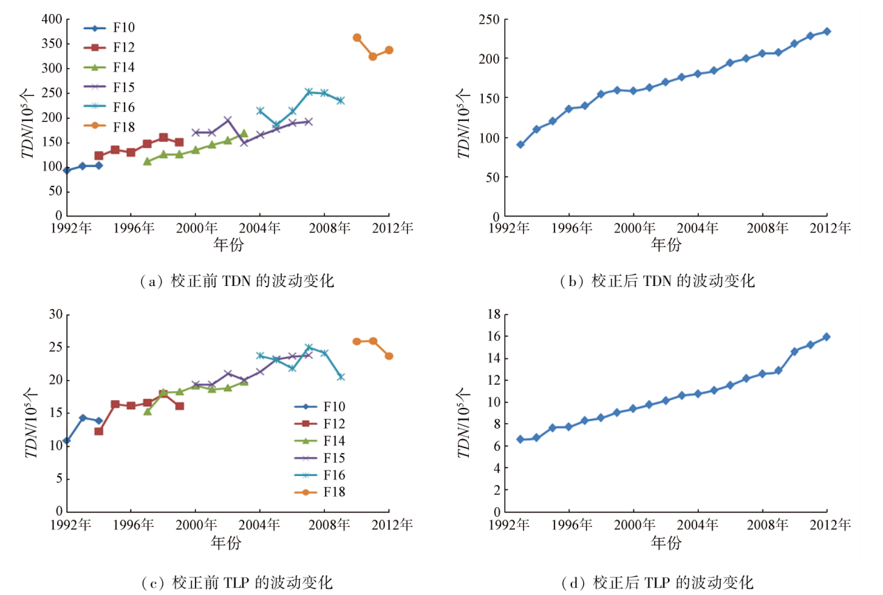
driving force
DMSP/OLS
NPP/VIIRS
Central Plains urban agglomeration
|
|
|
|
Issue Date: 13 March 2024
|
|
|
| [1] |
Chakraborty S, Maity I, Dadashpoor H, et al. Building in or out? Examining urban expansion patterns and land use efficiency across the global sample of 466 cities with million+ inhabitants[J]. Habitat International, 2022, 120:102503.
doi: 10.1016/j.habitatint.2021.102503
url: https://linkinghub.elsevier.com/retrieve/pii/S0197397521001922
|
| [2] |
Azabdaftari A, Sunar F. District-based urban expansion monitoring using multitemporal satellite data:Application in two mega cities[J]. Environmental Monitoring and Assessment, 2022, 194(5):33.
doi: 10.1007/s10661-021-09657-z
|
| [3] |
朱磊, 岳嘉琛, 陈诗音, 等. 1992—2016年京津冀城市群城市扩展过程和驱动分析[J]. 北京师范大学学报(自然科学版), 2019, 55(2):291-298.
|
| [3] |
Zhu L, Yue J C, Chen S Y, et al. Urban expansion in Beijing-Tianjin-Hebei urban agglomeration from 1992 to 2016:The process and driving forces[J]. Journal of Beijing Normal University(Natural Science), 2019, 55(2):291-298.
|
| [4] |
欧阳晓, 朱翔, 贺清云. 城市群城市用地扩张时空特征及驱动机制研究——以长株潭城市群为例[J]. 长江流域资源与环境, 2020, 29(6):1298-1309.
|
| [4] |
Ouyang X, Zhu X, He Q Y. Study of spatio-temporal pattern and driving mechanism of urban land expansion in urban agglomeration:A case study of the Changsha-Zhuzhou-Xiangtan urban agglomeration[J]. Resources and Environment in the Yangtze Basin, 2020, 29(6):1298-1309.
|
| [5] |
宋艳华, 焦利民, 刘稼丰, 等. 城市扩张程度的影响因素分析——以武汉市为例[J]. 武汉大学学报(信息科学版), 2021, 46(3):417-426.
|
| [5] |
Song Y H, Jiao L M, Liu J F, et al. Analysis of the factors affecting the degree of urban expansion:Taking Wuhan city as an example[J]. Geomatics and Information Science of Wuhan University, 2021, 46(3):417-426.
|
| [6] |
廖建军, 李欣, 王志远, 等. 长株潭都市圈建设用地增长格局及驱动因素研究[J/OL]. 世界地理研究, 2021:1-16[2021-09-07]. http://kns.cnki.net/kcms/detail/31.1626.p.20210906.1512.002.html.
url: http://kns.cnki.net/kcms/detail/31.1626.p.20210906.1512.002.html
|
| [6] |
Liao J J, Li X, Wang Z Y, et al. Research on the growth pattern and driving factors of construction land in CZT metropolitan area[J/OL]. World Regional Studies, 2021:1-16[2021-09-07]. http://kns.cnki.net/kcms/detail/31.1626.p.20210906.1512.002.html.
url: http://kns.cnki.net/kcms/detail/31.1626.p.20210906.1512.002.html
|
| [7] |
石天戈, 时卉. 基于地理探测器的乌鲁木齐城市扩张特征与时空驱动因素分析[J]. 干旱区地理, 2021, 44(3):867-876.
|
| [7] |
Shi T G, Shi H. Urban expansion and its temporal and spatial driving forces of Urumqi based on geo-detector method[J]. Arid Land Geography, 2021, 44(3):867-876.
|
| [8] |
Yang L, Li X, Shang B. Impacts of urban expansion on the urban thermal environment:A case study of Changchun,China[J]. Chinese Geographical Science, 2022, 32(1):79-92.
doi: 10.1007/s11769-021-1251-3
|
| [9] |
Yuan Z, Zhou L, Sun D, et al. Impacts of urban expansion on the loss and fragmentation of cropland in the major grain production areas of China[J]. Land, 2022, 11(1):130.
doi: 10.3390/land11010130
url: https://www.mdpi.com/2073-445X/11/1/130
|
| [10] |
史海金, 吴文恒, 李研, 等. 基于夜间灯光影像数据的黄河流域中心城市建成区空间扩展及动力因子分析[J]. 中国沙漠, 2021, 41(6):235-248.
doi: 10.7522/j.issn.1000-694X.2021.00126
|
| [10] |
Shi H J, Wu W H, Li Y, et al. Study on spatial expansion and dynamic factors of built-up area of central cities in the Yellow River Basin based on night-time light data[J]. Journal of Desert Research. 2021, 41(6):235-248.
|
| [11] |
Han J. Can urban sprawl be the cause of environmental deterioration? Based on the provincial panel data in China[J]. Environmental Research, 2020, 189:109954.
doi: 10.1016/j.envres.2020.109954
url: https://linkinghub.elsevier.com/retrieve/pii/S0013935120308495
|
| [12] |
Xu P, Jin P, Cheng Q. Monitoring regional urban dynamics using DMSP/OLS nighttime light data in Zhejiang Province[J]. Mathematical Problems in Engineering, 2020:9652808.
|
| [13] |
Jiang S, Wei G, Zhang Z, et al. Detecting the dynamics of urban growth in Africa using DMSP/OLS nighttime light data[J]. Land, 2020, 10(1):13.
doi: 10.3390/land10010013
url: https://www.mdpi.com/2073-445X/10/1/13
|
| [14] |
Li L, Zhao K, Wang X, et al. Spatio-temporal evolution and driving mechanism of urbanization in small cities:Case study from Guangxi[J]. Land, 2022, 11(3):415.
doi: 10.3390/land11030415
url: https://www.mdpi.com/2073-445X/11/3/415
|
| [15] |
Jiang L, Liu Y, Wu S, et al. Study on urban spatial pattern based on DMSP/OLS and NPP/VIIRS in Democratic People’s Republic of Korea[J]. Remote Sensing, 2021, 13(23):4879.
doi: 10.3390/rs13234879
url: https://www.mdpi.com/2072-4292/13/23/4879
|
| [16] |
林之强, 彭双云, 洪亮, 等. 基于夜光数据的滇中城市建成区动态监测与时空格局演变[J]. 水土保持研究, 2021, 28(1):265-271.
|
| [16] |
Lin Z Q, Peng S Y, Hong L, et al. Dynamic monitoring and spatial-temporal pattern evolution of buil-up areas in central Yunnan based on nighttime light data[J]. Research of Soil and Water Conservation, 2021, 28(1):265-271.
|
| [17] |
中华人民共和国国家发展和改革委员会. 国家发展改革委关于印发中原城市群发展规划的通知[EB/OL].(2016-12-29)[2022-12-07]. https://www.ndrc.gov.cn/xxgk/zcfb/ghwb/201701/t20170105_962218.html.
url: https://www.ndrc.gov.cn/xxgk/zcfb/ghwb/201701/t20170105_962218.html
|
| [17] |
National Development and Reform Commission. Notice of the National Development and Reform Commission on issuing the development plan for the Central Plains urban agglomeration[EB/OL].(2016-12-29)[2022-12-07]. https://www.ndrc.gov.cn/xxgk/zcfb/ghwb/201701/t20170105_962218.html.
url: https://www.ndrc.gov.cn/xxgk/zcfb/ghwb/201701/t20170105_962218.html
|
| [18] |
郭爱君, 毛锦凰. 丝绸之路经济带建设中的我国节点城市产业定位与协同发展研究[J]. 西北大学学报(哲学社会科学版), 2015, 45(4):18-27.
|
| [18] |
Guo A J, Mao J H. A study on the industry positioning and synergetic development of the node cities of China on the Silk-Road Economic Belt[J]. Journal of Northwest University (Philosophy and Social Sciences Edition), 2015, 45(4):18-27.
|
| [19] |
和舒敏. 中原城市群城市用地扩张的时空格局特征及驱动因素分析[D]. 郑州: 华北水利水电大学, 2020.
|
| [19] |
He S M. Analysis of spatial-temporal pattern characteristics and driving factors of urban land expansion in the central plains urban agglomeration[D]. Zhengzhou: North China University of Water Resources and Electric Power, 2020.
|
| [20] |
Liu Z, He C, Zhang Q, et al. Extracting the dynamics of urban expansion in China using DMSP-OLS nighttime light data from 1992 to 2008[J]. Landscape and Urban Planning, 2012, 106(1):62-72.
doi: 10.1016/j.landurbplan.2012.02.013
url: https://linkinghub.elsevier.com/retrieve/pii/S0169204612000643
|
| [21] |
闫庆武, 厉飞, 李玲. 基于2种夜间灯光影像亮度修正指数的城市建成区提取研究[J]. 地球信息科学学报, 2020, 22(8):1714-1724.
doi: 10.12082/dqxxkx.2020.200128
|
| [21] |
Yan Q W, Li F, Li L. Research on built-up area extraction via brightness correction indexes based on two kinds of nighttime light images[J]. Journal of Geo-information Science, 2020, 22(8):1714-1724.
|
| [22] |
陈颖彪, 郑子豪, 吴志峰, 等. 夜间灯光遥感数据应用综述和展望[J]. 地理科学进展, 2019, 38(2):205-223.
doi: 10.18306/dlkxjz.2019.02.005
|
| [22] |
Chen Y B, Zheng Z H, Wu Z F, et al. Review and prospect of application of nighttime light remote sensing data[J]. Progress in Geography, 2019, 38(2):205-223.
doi: 10.18306/dlkxjz.2019.02.005
|
| [23] |
Elvidge C D, Zhizhin M, Ghosh T, et al. Annual time series of global VIIRS nighttime lights derived from monthly averages:2012 to 2019[J]. Remote Sensing, 2021, 13(5):922.
doi: 10.3390/rs13050922
url: https://www.mdpi.com/2072-4292/13/5/922
|
| [24] |
胡苗苗. 长三角省际人口迁入的空间分异及影响机制研究[D]. 徐州: 中国矿业大学, 2019.
|
| [24] |
Hu M M. Spatial differentiation and influence mechanism of inter-provincial immigration in the Yangtze River delta[D]. Xuzhou: China University of Mining and Technology, 2019.
|
| [25] |
舒松, 余柏蒗, 吴健平, 等. 基于夜间灯光数据的城市建成区提取方法评价与应用[J]. 遥感技术与应用, 2011, 26(2):169-176.
|
| [25] |
Shu S, Yu B L, Wu J P, et al. Methods for deriving urban built-up area using night-light data:Assessment and application[J]. Remote Sensing Technology and Application, 2011, 26(2):169-176.
|
| [26] |
黄铁兰, 罗婧, 高照忠, 等. 基于DMSP-OLS和珞珈一号夜光遥感影像的粤港澳大湾区城市空间格局演变[J]. 测绘通报, 2021(12):10-15.
doi: 10.13474/j.cnki.11-2246.2021.364
|
| [26] |
Huang T L, Luo J, Gao Z Z, et al. Evolution of urban spatial pattern of GBA based on DMSP-OLS and LJ-1 nighttime light remote sensing images[J]. Bulletin of Surveying and Mapping, 2021(12):10-15.
doi: 10.13474/j.cnki.11-2246.2021.364
|
| [27] |
邓聚龙. 社会经济灰色系统的理论与方法[J]. 中国社会科学, 1984(6):47-60.
|
| [27] |
Deng J L. Theory and method of socio-economic grey system[J]. Social Sciences in China, 1984(6):47-60.
|
| [28] |
马歆, 和舒敏, 黄婷婷, 等. 城市用地扩张的时空格局特征及驱动因素分析——以中原城市群为例[J]. 生态经济, 2020, 36(3):105-111,167.
|
| [28] |
Ma X, He S M, Huang T T, et al. Analysis of spatial-temporal pattern characteristics and driving factors of urban land expansion:Taking central plains city cluster as an example[J]. Ecological Economy, 2020, 36(3):105-111,167.
|
| [29] |
王丰龙, 刘云刚. 中国城市建设用地扩张与财政收入增长的面板格兰杰因果检验[J]. 地理学报, 2013, 68(12):1595-1606.
doi: 10.11821/dlxb201312001
|
| [29] |
Wang F L, Liu Y G. Panel Granger Test on urban land expansion and fiscal revenue growth in China’s prefecture-level cities[J]. Acta Geographica Sinica, 2013, 68(12):1595-1606.
|
|
Viewed |
|
|
|
Full text
|
|
|
|
|
Abstract
|
|
|
|
|
Cited |
|
|
|
|
| |
Shared |
|
|
|
|
| |
Discussed |
|
|
|
|
 2024,
Vol. 36
2024,
Vol. 36