|
|
|
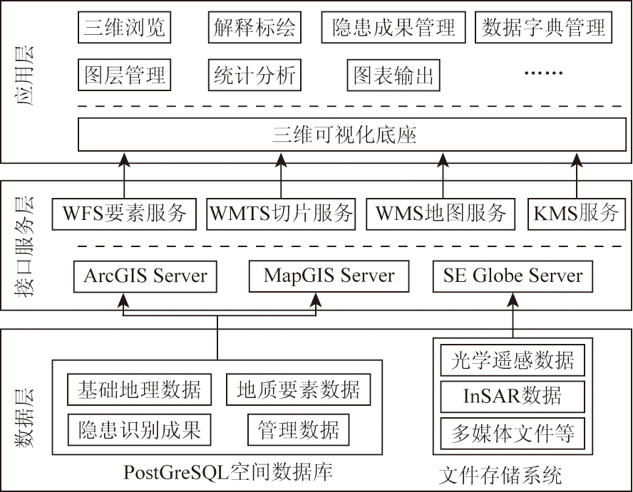
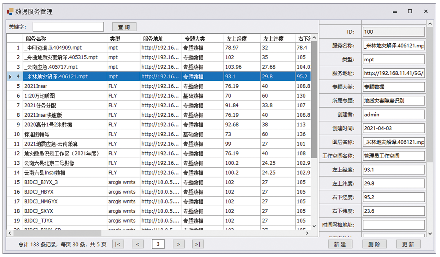
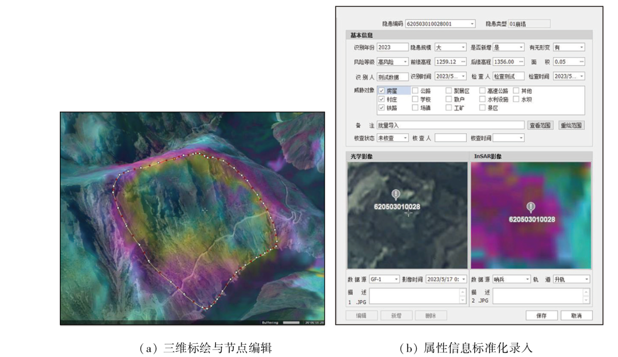
Abstract In recent years, geological hazard identification based on integrated remote sensing has been widely carried out, featuring wide surveyed areas, high time pressure, and heavy tasks. To meet the demand for the effective utilization of multi-source remote sensing data, multi-person collaboration, and quick result integration, along with the requirements of geological hazard identification tools, this study established a 3D geological hazard identification information platform. This platform, adopting a C/S architecture, allows for the effective organization and management of multi-source optical and radar remote sensing data, vector data, and 3D models and possesses functions such as the loading of multi-source data, multi-person collaboration, quick interpretations and identification, and result expression and output. This platform has successively supported fine-scale identification of hidden hazards and multiple emergency security efforts in national key areas with high geologic hazard susceptibility, such as Gansu, Yunnan, and Sichuan provinces. The application results indicate that this platform allows for rapid data supply and assists in improving work efficiency.
|
| Keywords
geological hazard identification
remote sensing interpretation
3D GIS platform
multi-source data management
|
|
|
|
Issue Date: 23 December 2024
|
|
|
| [1] |
刘斌, 葛大庆, 王珊珊, 等. TOPS和ScanSAR模式InSAR在广域地灾隐患识别中的联合应用[J]. 武汉大学学报(信息科学版), 2020, 45(11):1756-1762.
|
| [1] |
Liu B, Ge D Q, Wang S S, et al. Combining application of TOPS and ScanSAR InSAR in large-scale geohazards identification[J]. Geomatics and Information Science of Wuhan University, 2020, 45(11):1756-1762.
|
| [2] |
葛大庆, 戴可人, 郭兆成, 等. 重大地质灾害隐患早期识别中综合遥感应用的思考与建议[J]. 武汉大学学报(信息科学版), 2019, 44(7):949-956.
|
| [2] |
Ge D Q, Dai K R, Guo Z C, et al. Early identification of serious geological hazards with integrated remote sensing technologies:Thoughts and recommendations[J]. Geomatics and Information Science of Wuhan University, 2019, 44(7):949-956.
|
| [3] |
许强, 董秀军, 李为乐. 基于天-空-地一体化的重大地质灾害隐患早期识别与监测预警[J]. 武汉大学学报(信息科学版), 2019, 44(7):957-966.
|
| [3] |
Xu Q, Dong X J, Li W L. Integrated space-air-ground early detection,monitoring and warning system for potential catastrophic geohazards[J]. Geomatics and Information Science of Wuhan University, 2019, 44(7):957-966.
|
| [4] |
童立强, 郭兆成. 典型滑坡遥感影像特征研究[J]. 国土资源遥感, 2013, 25(1):86-92.doi:10.6046/gtzyyg.2013.01.16.
|
| [4] |
Tong L Q, Guo Z C. A study of remote sensing image features of typical landslides[J]. Remote Sensing for Land and Resources, 2013, 25(1):86-92.doi:10.6046/gtzyyg.2013.01.16.
|
| [5] |
童立强. “5·12”汶川大地震极重灾区地震堰塞湖应急遥感调查[J]. 国土资源遥感, 2008, 20(3):61-63,112.doi:10.6046/gtzyyg.2008.03.14.
|
| [5] |
Tong L Q. Emergency remote sensing investigation of barrier lakes at the quake center area caused by “5·12” Wenchuan strong earthquake[J]. Remote Sensing for Land and Resources, 2008, 20(3):61-63,112.doi:10.6046/gtzyyg.2008.03.14.
|
| [6] |
刘春玲, 童立强, 祁生文, 等. 喜马拉雅山地区冰川湖溃决灾害隐患遥感调查及影响因素分析[J]. 国土资源遥感, 2016, 28(3):110-115.doi:10.6046/gtzyyg.2016.03.18.
|
| [6] |
Liu C L, Tong L Q, Qi S W, et al. Remote sensing investigation and influence factor analysis of glacier lake outburst potential in the Himalayas[J]. Remote Sensing for Land and Resources, 2016, 28(3):110-115.doi:10.6046/gtzyyg.2016.03.18.
|
| [7] |
童立强, 张晓坤, 李曼, 等. “6·28”关岭滑坡特大地质灾害应急遥感调查研究[J]. 国土资源遥感, 2010, 22(3):65-68.doi:10.6046/gtzyyg.2010.03.14.
|
| [7] |
Tong L Q, Zhang X K, Li M, et al. Emergency remote sensing research on superlarge geological disasters caused by “6·28” Guanling landslide[J]. Remote Sensing for Land and Resources, 2010, 22(3):65-68.doi:10.6046/gtzyyg.2010.03.14.
|
| [8] |
周伟, 黄炜, 王彦佐, 等. 资源一号02C卫星数据管理与服务系统研建[J]. 国土资源遥感, 2014, 26(1):179-185. doi:10.6046/gtzyyg.2014.01.30.
|
| [8] |
Zhou W, Huang W, Wang Y Z, et al. Tentative construction of satellite data management and service system for ZY-1 02C[J]. Remote Sensing for Land and Resources, 2014, 26(1):179-185.doi:10.6046/gtzyyg.2014.01.30.
|
| [9] |
王彦佐, 周伟, 冯磊. 内存数据库在ZY1-02C海量数据空间检索中的应用[J]. 国土资源遥感, 2018, 30(1):238-242.doi:10.6046/gtzyyg.2018.01.33.
|
| [9] |
Wang Y Z, Zhou W, Feng L. Application of main memory database to spatial query of mass ZY1-02C data[J]. Remote Sensing for Land and Resources, 2018, 30(1):238-242.doi:10.6046/gtzyyg.2018.01.33.
|
| [10] |
随欣欣, 眭素文, 刘锟. 面向遥感业务应用的解译成果数据管理系统研究和构建[J]. 国土资源遥感, 2018, 30(3):238-243.doi:10.6046/gtzyyg.2018.03.32.
|
| [10] |
Sui X X, Sui S W, Liu K. Research and construction of interpretation result data management system toward remote sensing application[J]. Remote Sensing for Land and Resources, 2018, 30(3):238-243.doi:10.6046/gtzyyg.2018.03.32.
|
| [11] |
随欣欣, 眭素文. 基于MapGIS和ArcGIS的遥感解译成果图件数据库设计与实现[J]. 国土资源遥感, 2018, 30(4):218-224.doi:10.6046/gtzyyg.2018.04.33.
|
| [11] |
Sui X X, Sui S W. Design and implementation of remote sensing interpretation map database based on MapGIS and ArcGIS[J]. Remote Sensing for Land and Resources, 2018, 30(4):218-224.doi:10.6046/gtzyyg.2018.04.33.
|
| [12] |
郭兆成, 周成虎, 孙晓宇, 等. 汶川地震触发崩滑地质灾害空间分布及影响因素[J]. 地学前缘, 2010, 17(5):234-242.
|
| [12] |
Guo Z C, Zhou C H, Sun X Y, et al. The distribution of landslide triggered by Wenchuan earthquake and its causative factors[J]. Earth Science Frontiers, 2010, 17(5):234-242.
|
| [13] |
侯兴泽, 蒋大鹏, 徐健, 等. 三维GIS在地质灾害隐患防治中的应用研究[J]. 测绘, 2020, 43(2):63-67.
|
| [13] |
Hou X Z, Jiang D P, Xu J, et al. Research on the application of 3D GIS in geological hazard prevention and control[J]. Surveying and Mapping, 2020, 43(2):63-67.
|
| [14] |
王轶, 张晓坤, 童立强. 三峡库区遥感三维立体仿真系统及其应用[J]. 遥感信息, 2012, 27(4):40-43.
|
| [14] |
Wang Y, Zhang X K, Tong L Q. Development and application of a 3D simulation system based on remotely sensed information within Three Gorges Reservoir area[J]. Remote Sensing Information, 2012, 27(4):40-43.
|
| [15] |
乌云其其格, 马维峰, 张时忠, 等. 基于三维的地质灾害遥感解译标志管理系统设计与实现[J]. 国土资源遥感, 2012, 24(2):148-151.doi:10.6046/gtzyyg.2012.02.27.
|
| [15] |
Wu Y, Ma W F, Zhang S Z, et al. The design and dvelopment of the interpreting marks management system for geological disasters based on 3D[J]. Remote Sensing for Land and Resources, 2012, 24(2):148-151.doi:10.6046/gtzyyg.2012.02.27.
|
|
Viewed |
|
|
|
Full text
|
|
|
|
|
Abstract
|
|
|
|
|
Cited |
|
|
|
|
| |
Shared |
|
|
|
|
| |
Discussed |
|
|
|
|
 2024,
Vol. 36
2024,
Vol. 36
 ), WANG Yi(