|
|
 |
|

|
|
|
Urban heat island effects of Nanjing based on urban expansion directions and types derived from remote sensing data |
WANG Yuexiang1,2( ), CHEN Wanting1, ZHU Yuxin1, CAI Anning1,3() ), CHEN Wanting1, ZHU Yuxin1, CAI Anning1,3() |
1. School of Urban and Environmental Sciences, Huaiyin Normal University, Huai’an 223300, China
2. School of Public Policy and Management(School of Emergency Management), China University of Mining and Technology, Xuzhou 221116, China
3. Tourism and Social Administration College, Nanjing Xiaozhuang University, Nanjing 211171, China |
|
|
|
|
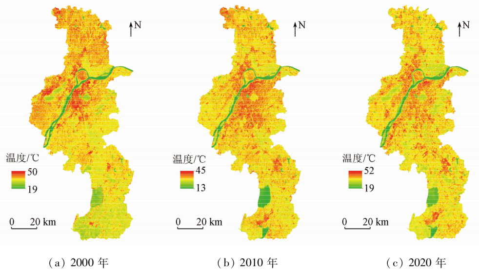
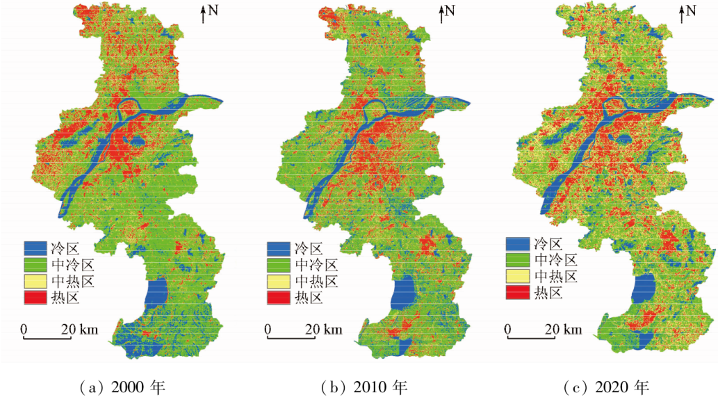
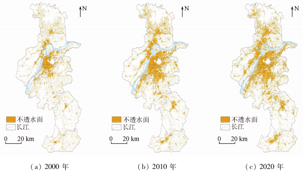
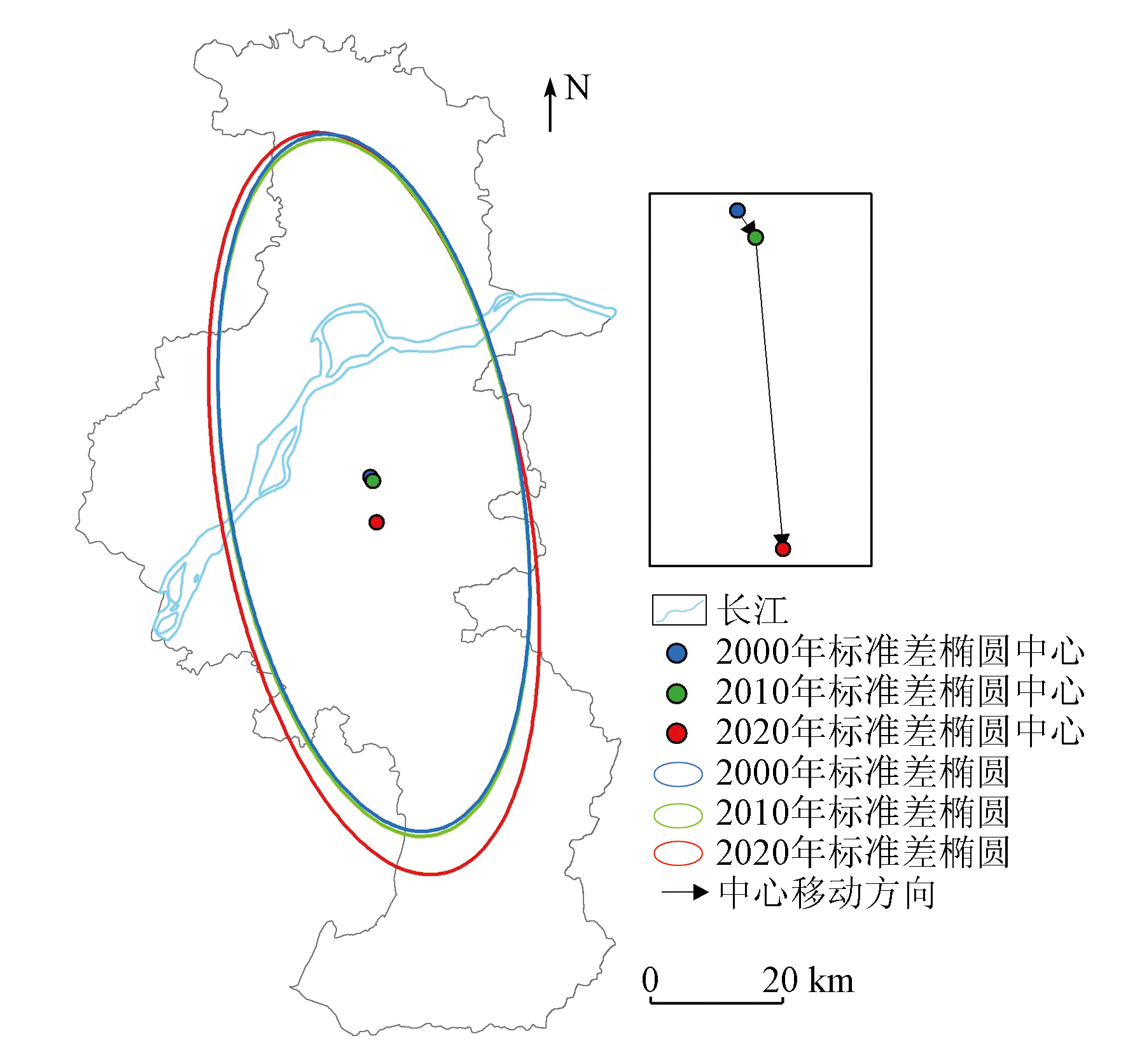
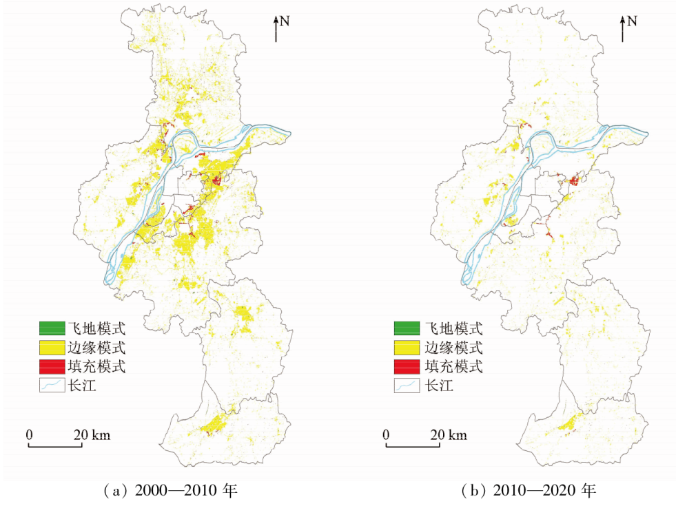
Abstract Delving into the urban heat island effects caused by urban expansion holds crucial significance for addressing urban thermal environment challenges. Based on the Landsat remote sensing images of Nanjing in 2000, 2010, and 2020, this study obtained Nanjing’s surface temperatures through inversion using the radiative transfer equation and extracted the impervious surface information using the biophysical composition index (BCI). It analyzed the urban expansion directions and types of Nanjing from 2000 to 2020 by employing the standard deviation ellipse and the landscape expansion index. Moreover, it investigated the effects of urban expansion types on the thermal environment through statistical analysis. The results are as follows: ① From 2000 to 2020, Nanjing experienced an increase in surface temperatures from 29 ℃ to 30 ℃ and an expansion of the heat island area from 2 248 km2 to 3 051 km2. The urban heat island expanded towards the south between 2000 and 2010 and spread to the surrounding areas between 2010 and 2020; ② The urban land of Nanjing expanded outwards from its center, mainly towards the south. The expansion types were dominated by edge expansion, succeeded by infilling and exclave expansions. The proportion of edge expansion between 2000 and 2010 was slightly higher than that between 2010 and 2020; ③ The urban expansion exhibited the same direction as the urban heat island expansion, and edge expansion resulted in the most intense urban heat island effects, followed by exclave and infilling expansions. This study can provide a scientific basis for ameliorating Nanjing’s thermal environment based on the urban expansion types and directions.
|
| Keywords
impervious surface
urban expansion type
urban heat island effect
spatial analysis
|
|
|
|
Issue Date: 21 December 2023
|
|
|
| [1] |
Zhang Y, Liu J, Wen Z. Predicting surface urban heat island in Meihekou City,China:A combination method of Monte Carlo and random forest[J]. Chinese Geographical Science, 2021, 31(4):659-670.
doi: 10.1007/s11769-021-1215-7
|
| [2] |
Estoque R C, Murayama Y, Myint S W. Effects of landscape composition and pattern on land surface temperature:An urban heat island study in the megacities of southeast Asia[J]. Science of the Total Environment, 2017, 577:349-359.
doi: 10.1016/j.scitotenv.2016.10.195
url: https://linkinghub.elsevier.com/retrieve/pii/S0048969716323853
|
| [3] |
刘新, 刘寿东, 赵小艳, 等. 南京城市化进程与热岛效应的初步研究[J]. 长江流域资源与环境, 2013, 22(12):1543-1549.
|
| [3] |
Liu X, Liu S D, Zhao X Y, et al. A preliminary research of urbanization process and heat island effect in Nanjing[J]. Resources and Environment in the Yangtze Basin, 2013, 22(12):1543-1549.
|
| [4] |
朱俊峰, 马苗苗, 耿丽艳. 基于遥感指数的南京市城市热岛时空演变分析[J]. 地理信息世界, 2021, 28(5):52-57.
|
| [4] |
Zhu J F, Ma M M, Geng L Y. Spatiotemporal evolution analysis of urban heat island in Nanjing City based on remote sensing index[J]. Geomatics World, 2021, 28(5):52-57.
|
| [5] |
裴欢, 房世峰. 南京市夏季热岛特征及其与土地利用覆盖关系研究[J]. 干旱气象, 2008, 26(1):23-27.
|
| [5] |
Pei H, Fang S F. Characteristics of heat island in Nanjing and relationship between heat island and land use/cover[J]. Arid Meteoro-logy, 2008, 26(1):23-27.
|
| [6] |
周正龙, 沙晋明, 季建万. 福州主城区热岛效应与不透水面的关系及时空变化分析[J]. 福建师范大学学报(自然科学版), 2019, 35(1):19-27.
|
| [6] |
Zhou Z L, Sha J M, Ji J W. The study of the relationship between urban heat island effect and impervious surface and spatio-temporal change in urban areas of Fuzhou[J]. Journal of Fujian Normal University (Natural Science Edition), 2019, 35(1):19-27.
|
| [7] |
徐涵秋, 王美雅. 地表不透水面信息遥感的主要方法分析[J]. 遥感学报, 2016, 20(5):1270-1289.
|
| [7] |
Xu H Q, Wang M Y. Remote sensing-based retrieval of ground impervious surfaces[J]. Journal of Remote Sensing, 2016, 20(5):1270-1289.
|
| [8] |
Deng C, Wu C. BCI:A biophysical composition index for remote sensing of urban environments[J]. Remote Sensing of Environment, 2012, 127:247-259.
doi: 10.1016/j.rse.2012.09.009
url: https://linkinghub.elsevier.com/retrieve/pii/S003442571200363X
|
| [9] |
Xu H Q. Analysis of impervious surface and its impact on urban heat environment using the normalized difference impervious surface index (NDISI)[J]. Photogrammetric Engineering and Remote Sensing, 2010, 76(5):557-565.
doi: 10.14358/PERS.76.5.557
url: http://openurl.ingenta.com/content/xref?genre=article&issn=0099-1112&volume=76&issue=5&spage=557
|
| [10] |
查勇, 倪绍祥, 杨山. 一种利用TM图像自动提取城镇用地信息的有效方法[J]. 遥感学报, 2003, 7(1):37-40,82.
|
| [10] |
Zha Y, Ni S X, Yang S. An effective approach to automatically extract urban land-use from TM lmagery[J]. Journal of Remote Sensing, 2003, 7(1):37-40,82.
|
| [11] |
侯宇初, 张冬有. 基于Landsat8遥感影像的地表温度反演方法对比研究[J]. 中国农学通报, 2019, 35(10):142-147.
doi: 10.11924/j.issn.1000-6850.casb18120100
|
| [11] |
Hou Y C, Zhang D Y. Comparison study on land surface temperature retrieval algorithms based on Landsat8 remote sensing image[J]. Chinese Agricultural Science Bulletin, 2019, 35(10):142-147.
|
| [12] |
Xian G. Satellite remotely-sensed land surface parameters and their climatic effects for three metropolitan regions[J]. Advances in Space Research, 2008, 41(11):1861-1869.
doi: 10.1016/j.asr.2007.11.004
url: https://linkinghub.elsevier.com/retrieve/pii/S0273117707010721
|
| [13] |
李海峰. 基于TM影像的地表温度反演算法研究[J]. 电脑知识与技术, 2017, 13(2):223-225.
|
| [13] |
Li H F. Research on inversion algorithm of surface temperature based on TM image[J]. Computer Knowledge and Technology, 2017, 13(2):223-225.
|
| [14] |
覃志豪, 张明华, Karnieli A, 等. 用陆地卫星TM6数据演算地表温度的单窗算法[J]. 地理学报, 2001, 56(4):456-466.
doi: 10.11821/xb200104009
|
| [14] |
Qin Z H, Zhang M H, Karnieli A, et al. Mono-window algorithm for retrieving land surface temperature from Landsat TM6 data[J]. Acta Geographica Sinica, 2001, 56(4):456-466.
doi: 10.11821/xb200104009
|
| [15] |
Sobrino J A, Jiménez-Muñoz J C, Paolini L. Land surface temperature retrieval from LANDSAT TM5[J]. Remote Sensing of Environment, 2004, 90(4):434-440.
doi: 10.1016/j.rse.2004.02.003
url: https://linkinghub.elsevier.com/retrieve/pii/S0034425704000574
|
| [16] |
Yue W, Qiu S, Xu H, et al. Polycentric urban development and urban thermal environment:A case of Hangzhou,China[J]. Landscape and Urban Planning, 2019, 189:58-70.
doi: 10.1016/j.landurbplan.2019.04.008
url: https://linkinghub.elsevier.com/retrieve/pii/S0169204618310363
|
| [17] |
Peng J, Xie P, Liu Y, et al. Urban thermal environment dynamics and associated landscape pattern factors:A case study in the Beijing metropolitan region[J]. Remote Sensing of Environment, 2016, 173:145-155.
doi: 10.1016/j.rse.2015.11.027
url: https://linkinghub.elsevier.com/retrieve/pii/S0034425715302145
|
| [18] |
徐涵秋. 利用改进的归一化差异水体指数(MNDWI)提取水体信息的研究[J]. 遥感学报, 2005, 9(5):589-595.
|
| [18] |
Xu H Q. A study on information extraction of water body with the modified normalized difference water index (MNDWI)[J]. Journal of Remote Sensing, 2005, 9(5):589-595.
|
| [19] |
Gong J. Clarifying the standard deviational ellipse[J]. Geographical Analysis, 2002, 34(2):155-167.
doi: 10.1111/gean.2002.34.issue-2
url: https://onlinelibrary.wiley.com/toc/15384632/34/2
|
| [20] |
Wong D W S. Several fundamentals in implementing spatial statistics in GIS:Using centrographic measures as examples[J]. Annals of GIS, 1999, 5(2):163-174.
doi: 10.1080/10824009909480525
url: http://www.tandfonline.com/doi/abs/10.1080/10824009909480525
|
| [21] |
刘小平, 黎夏, 陈逸敏, 等. 景观扩张指数及其在城市扩展分析中的应用[J]. 地理学报, 2009, 64(12):1430-1438.
doi: 10.11821/xb200912003
|
| [21] |
Liu X P, Li X, Chen Y M, et al. Landscape expansion index and its applications to quantitative analysis of urban expansion[J]. Acta Geographica Sinica, 2009, 64(12):1430-1438.
|
| [22] |
何青松, 王铭君, 才仁卓玛. 基于多维景观扩张指数的城市紧凑度分析研究[J]. 地理信息世界, 2021, 28(5):58-65.
|
| [22] |
He Q S, Wang M J, Cai R. Analysis of urban compactness based on multi-dimensional landscape expansion index[J]. Geomatics World, 2021, 28(5):58-65.
|
| [23] |
王宪凯, 孟庆岩, 李娟, 等. 北京市主城区不透水面时空演变及其热环境效应研究[J]. 生态科学, 2021, 40(1):169-181.
|
| [23] |
Wang X K, Meng Q Y, Li J, et al. Spatiotemporal evolution and thermal environmental effects of impervious surfaces in the main urban area of Beijing[J]. Ecological Science, 2021, 40(1):169-181.
|
| [24] |
马玉翎. 粤港澳大湾区城市群不透水面空间结构时空变化对地表热环境影响的研究[D]. 昆明: 云南师范大学, 2020.
|
| [24] |
Ma Y L. Impact of spatio-temporal changes of impervious surfaces spatial structure on land surface thermal environment in urban agglomeration of Guangdong-Hong Kong-Macao Greater Bay Area[D]. Kunming: Yunnan Normal University, 2020.
|
| [25] |
樊智宇, 詹庆明, 刘慧民, 等. 武汉市夏季城市热岛与不透水面增温强度时空分布[J]. 地球信息科学学报, 2019, 21(2):226-235.
doi: 10.12082/dqxxkx.2018.180495
|
| [25] |
Fan Z Y, Zhan Q M, Liu H M, et al. Spatial-temporal distribution of urban heat island and the heating effect of impervious surface in summer in Wuhan[J]. Journal of Geo-Information Science, 2019, 21(2):226-235.
|
| [26] |
王美雅, 徐涵秋, 李霞, 等. 不透水面时空变化及其对城市热环境影响的定量分析——以福州市建成区为例[J]. 应用基础与工程科学学报, 2018, 26(6):1316-1326.
|
| [26] |
Wang M Y, Xu H Q, Li X, et al. Analysis on spatiotemporal variation of urban impervious surface and its influence on urban thermal environment:Fuzhou City,China[J]. Journal of Basic Science and Engineering, 2018, 26(6):1316-1326.
|
|
Viewed |
|
|
|
Full text
|
|
|
|
|
Abstract
|
|
|
|
|
Cited |
|
|
|
|
| |
Shared |
|
|
|
|
| |
Discussed |
|
|
|
|
 2023,
Vol. 35
2023,
Vol. 35