|
|
 |
|

|
|
|
Self-learning segmentation of high-resolution remote sensing images based on visual dual-drive cognition |
WU Zhijun1( ), CONG Ming1(), XU Miaozhong2, HAN Ling1, CUI Jianjun1, ZHAO Chaoying1, XI Jiangbo1, YANG Chengsheng1, DING Mingtao1, REN Chaofeng1, GU Junkai1, PENG Xiaodong1, TAO Yiting2 ), CONG Ming1(), XU Miaozhong2, HAN Ling1, CUI Jianjun1, ZHAO Chaoying1, XI Jiangbo1, YANG Chengsheng1, DING Mingtao1, REN Chaofeng1, GU Junkai1, PENG Xiaodong1, TAO Yiting2 |
1. College of Geological Engineering and Geomatics,Chang’an University,Xi’an 710064,China
2. State Key Laboratory of Information Engineering in Surveying,Mapping and Remote Sensing,Wuhan University,Wuhan 430072,China |
|
|
|
|
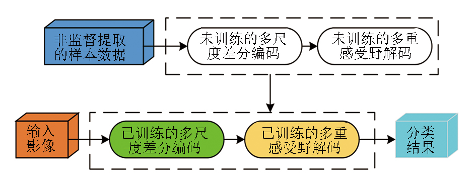
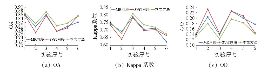
Abstract The current high-resolution remote sensing images involve complex scenes that are difficult to analyze. Meanwhile,owing to the diverse scenes,there is a lack of accurate reference obtained from the sample database. Therefore,this paper proposed a self-learning segmentation method for high-resolution remote sensing images,with reference to the visual dual-drive cognition mechanism. Based on the principle of visual perception,this method interpreted the typical ground objects in the scene through unsupervised adaptive analysis. In addition,it achieved self-learning identification of typical ground objects by integrating a neural network. Finally,the segmentation results were self-checked and corrected by combining unsupervised analysis and neural network learning. Using real high-resolution remote sensing image data containing complex ground scenes,the comparative experiments were conducted between the proposed method and two popular deep neural network segmentation methods:mask region-based convolutional neural network (Mask R-CNN) and scalable vision transformer (ScalableViT). The results showed that the proposed method can maintain robust and reliable segmentation accuracy,and outperformed others in terms of ground object cognition,generalization performance,and anti-interference ability. As such,it proved to be a cost-effective and practical approach.
|
| Keywords
bionic visual
high-resolution remote sensing
image segmentation
unsupervised analysis
deep learning neural network
self-learning method
|
|
|
|
Issue Date: 28 October 2025
|
|
|
| [1] |
Pan X, Zhang C, Xu J, et al. Simplified object-based deep neural network for very high resolution remote sensing image classification[J]. ISPRS Journal of Photogrammetry and Remote Sensing, 2021, 181:218-237.
|
| [2] |
程结海, 黄中意, 王建如, 等. 高空间分辨率遥感影像最优分割结果自动确定方法[J]. 测绘学报, 2022, 51(5):658-667.
doi: 10.11947/j.AGCS.2022.20210423
|
| [2] |
Cheng J H, Huang Z Y, Wang J R, et al. The automatic determination method of the optimal segmentation result of high-spatial resolution remote sensing image[J]. Acta Geodaetica et Cartographica Sinica, 2022, 51(5):658-667.
doi: 10.11947/j.AGCS.2022.20210423
|
| [3] |
吴强强, 王帅, 王彪, 等. 空间信息感知语义分割模型的高分辨率遥感影像道路提取[J]. 遥感学报, 2022, 26(9):1872-1885.
|
| [3] |
Wu Q Q, Wang S, Wang B, et al. Road extraction method of high-resolution remote sensing image on the basis of the spatial information perception semantic segmentation model[J]. National Remote Sensing Bulletin, 2022, 26(9):1872-1885.
|
| [4] |
Liu Y, Li E, Wang S, et al. Superpixel segmentation of high-resolution remote sensing image based on feature reconstruction method by salient edges[J]. Journal of Applied Remote Sensing, 2023, 17(2):026516.
|
| [5] |
邵振峰, 孙悦鸣, 席江波, 等. 智能优化学习的高空间分辨率遥感影像语义分割[J]. 武汉大学学报(信息科学版), 2022, 47(2):234-241.
|
| [5] |
Shao Z F, Sun Y M, Xi J B, et al. Intelligent optimization learning for semantic segmentation of high spatial resolution remote sensing images[J]. Geomatics and Information Science of Wuhan University, 2022, 47(2):234-241.
|
| [6] |
石雪. 基于层次化混合模型的高分辨率遥感影像分割方法研究[J]. 测绘学报, 2023, 52(1):168.
doi: 10.11947/j.AGCS.2023.20210147
|
| [6] |
Shi X. Hierarchical mixture model based high-resolution remote sensing image segmentation method[J]. Acta Geodaetica et Cartographica Sinica, 2023, 52(1):168.
doi: 10.11947/j.AGCS.2023.20210147
|
| [7] |
Cao Y, Huang X. A coarse-to-fine weakly supervised learning method for green plastic cover segmentation using high-resolution remote sensing images[J]. ISPRS Journal of Photogrammetry and Remote Sensing, 2022, 188:157-176.
|
| [8] |
Su Y, Cheng J, Bai H, et al. Semantic segmentation of very-high-resolution remote sensing images via deep multi-feature learning[J]. Remote Sensing, 2022, 14(3):533.
|
| [9] |
Ding C, Weng L, Xia M, et al. Non-local feature search network for building and road segmentation of remote sensing image[J]. ISPRS International Journal of Geo-Information, 2021, 10(4):245.
|
| [10] |
Ju H, Bi F, Bian M, et al. Multiscale feature fusion network for automatic port segmentation from remote sensing images[J]. Journal of Applied Remote Sensing, 2022, 16(4):044506.
|
| [11] |
周荣荣, 刘扬, 周一凡, 等. 基于语义分割的遥感影像建筑物自动提取方法[J]. 河南科学, 2023, 41(4):612-618.
|
| [11] |
Zhou R R, Liu Y, Zhou Y F, et al. Automatic building extraction from remote sensing images based on semantic segmentation[J]. Henan Science, 2023, 41(4):612-618.
|
| [12] |
刘勇, 郝新宇, 赵晨, 等. 结合分类和语义分割的遥感影像洪涝灾害检测方法[J]. 黑龙江大学工程学报, 2023, 14(1):76-82.
|
| [12] |
Liu Y, Hao X Y, Zhao C, et al. Remote sensing image flood disaster detection method based on classification and semantic segmentation[J]. Journal of Engineering of Heilongjiang University, 2023, 14(1):76-82.
|
| [13] |
王振华, 张鑫月, 刘智翔, 等. 遥感地物分割的改进格子玻尔兹曼并行模型[J]. 遥感信息, 2021, 36(4):1-6.
|
| [13] |
Wang Z H, Zhang X Y, Liu Z X, et al. Improved lattice Boltzmann parallel model for remote sensing object segmentation[J]. Remote Sensing Information, 2021, 36(4):1-6.
|
| [14] |
刘思言, 李玲, 特日根, 等. 基于直方图区域生长的遥感图像阈值分割算法[J]. 测绘通报, 2021(2):25-29.
doi: 10.13474/j.cnki.11-2246.2021.0037
|
| [14] |
Liu S Y, Li L, Te R G, et al. Threshold segmentation algorithm based on histogram region growing for remote sensing images[J]. Bulletin of Surveying and Mapping, 2021(2):25-29.
doi: 10.13474/j.cnki.11-2246.2021.0037
|
| [15] |
高瑞璞, 李礼. 使用超像素编码的交互式影像语义分割方法[J]. 测绘地理信息, 2022, 47(s1):148-152.
|
| [15] |
Gao R P, Li L. A method for interactive image semantic segmentation using superpixel encoding[J]. Journal of Geomatics, 2022, 47(s1):148-152.
|
| [16] |
张汉中. 基于小波域三重MRF分割算法的遥感图像分割分析[J]. 北京测绘, 2021, 35(7):866-869.
|
| [16] |
Zhang H Z. Analysis of remote sensing image segmentation based on wavelet domain triple MRF segmentation algorithm[J]. Beijing Surveying and Mapping, 2021, 35(7):866-869.
|
| [17] |
Song Y, Qu J. Real-time segmentation of remote sensing images with a combination of clustering and Bayesian approaches[J]. Journal of Real-Time Image Processing, 2021, 18(5):1541-1554.
|
| [18] |
苏腾飞. 深度卷积语义分割网络在农田遥感影像分类中的对比研究——以河套灌区为例[J]. 自然资源遥感, 2024, 36(4):210-217.doi:10.6046/zrzyyg.2023150.
|
| [18] |
Su T F. A comparative study on semantic segmentation-orientated deep convolutional networks for remote sensing image-based farmland classification:A case study of the Hetao irrigation district[J]. Remote Sensing for Natural Resources, 2024, 36(4):210-217.doi:10.6046/zrzyyg.2023150.
|
| [19] |
张瑞瑞, 夏浪, 陈立平, 等. 深度语义分割网络无人机遥感松材线虫病变色木识别[J]. 自然资源遥感, 2024, 36(3):216-224.doi:10.6046/zrzyyg.2023094.
|
| [19] |
Zhang R R, Xia L, Chen L P, et al. Identifying discolored trees inflected with pine wilt disease using DSSN-based UAV remote sensing[J]. Remote Sensing for Natural Resources, 2024, 36(3):216-224.doi:10.6046/zrzyyg.2023094.
|
| [20] |
杨军, 于茜子. 结合空洞卷积的FuseNet变体网络高分辨率遥感影像语义分割[J]. 武汉大学学报(信息科学版), 2022, 47(7):1071-1080.
|
| [20] |
Yang J, Yu X Z. Semantic segmentation of high-resolution remote sensing images based on improved FuseNet combined with atrous convolution[J]. Geomatics and Information Science of Wuhan University, 2022, 47(7):1071-1080.
|
| [21] |
Xi J B, Ersoy O K, Cong M, et al. Wide and deep Fourier neural network for hyperspectral remote sensing image classification[J]. Remote Sensing, 2022, 14(12):2931-2931.
|
| [22] |
潘建平, 李鑫, 孙博文, 等. 基于注意力密集连接金字塔网络的新增建设用地变化检测[J]. 测绘通报, 2022(3):41-46,59.
doi: 10.13474/j.cnki.11-2246.2022.0075
|
| [22] |
Pan J P, Li X, Sun B W, et al. Detection of new construction land change based on attention intensive connection pyramid network[J]. Bulletin of Surveying and Mapping, 2022(3):41-46,59.
doi: 10.13474/j.cnki.11-2246.2022.0075
|
| [23] |
孙汉淇, 潘晨, 何灵敏, 等. 多模态特征融合的遥感图像语义分割网络[J]. 计算机工程与应用, 2022, 58(24):256-264.
doi: 10.3778/j.issn.1002-8331.2207-0010
|
| [23] |
Sun H Q, Pan C, He L M, et al. Remote sensing image semantic segmentation network based on multimodal feature fusion[J]. Computer Engineering and Applications, 2022, 58(24):256-264.
doi: 10.3778/j.issn.1002-8331.2207-0010
|
| [24] |
Sun L, Cheng S, Zheng Y, et al. SPANet:Successive pooling attention network for semantic segmentation of remote sensing images[J]. IEEE Journal of Selected Topics in Applied Earth Observations and Remote Sensing, 2022, 15:4045-4057.
|
| [25] |
Cong M, Xi J, Han L, et al. Multi-resolution classification network for high-resolution UAV remote sensing images[J]. Geocarto International, 2022, 37(11):3116-3140.
|
| [26] |
刘晨晨, 葛小三, 武永斌, 等. 基于混合注意力机制和Deeplabv3+的遥感影像建筑物提取方法[J]. 自然资源遥感, 2025, 37(1):31-37.doi:10.6046/zrzyyg.2023295.
|
| [26] |
Liu C C, Ge X S, Wu Y B, et al. A method for information extraction of buildings from remote sensing images based on hybrid attention mechanism and Deeplabv3+[J]. Remote Sensing for Natural Resources, 2025, 37(1):31-37.doi:10.6046/zrzyyg.2023295.
|
| [27] |
曲海成, 梁旭. 融合混合注意力机制与多尺度特征增强的高分影像建筑物提取[J]. 自然资源遥感, 2024, 36(4):107-116.doi:10.6046/zrzyyg.2023146.
|
| [27] |
Qu H C, Liang X. Building extraction from high-resolution images using a hybrid attention mechanism combined with multi-scale feature enhancement[J]. Remote Sensing for Natural Resources, 2024, 36(4):107-116.doi:10.6046/zrzyyg.2023146.
|
| [28] |
冯炜明, 张新长, 孙颖, 等. 融合Transformer结构的高分辨率遥感影像变化检测网络[J]. 测绘通报, 2022(8):36-40,92.
doi: 10.13474/j.cnki.11-2246.2022.0229
|
| [28] |
Feng W M, Zhang X C, Sun Y, et al. High-resolution remote sens-ing image change detection network with Transformer structure[J]. Bulletin of Surveying and Mapping, 2022(8):36-40,92.
|
| [29] |
He Q B, Sun X, Diao W H, et al. Multimodal remote sensing image segmentation with intuition-inspired hypergraph modeling[J]. IEEE Transactions on Image Processing, 2023, 32:1474-1487.
|
| [30] |
马妍, 古丽米拉·克孜尔别克. 图像语义分割方法在高分辨率遥感影像解译中的研究综述[J]. 计算机科学与探索, 2023, 17(7):1526-1548.
doi: 10.3778/j.issn.1673-9418.2211015
|
| [30] |
Ma Y, Gulimila K. Research review of image semantic segmentation method in high-resolution remote sensing image interpretation[J]. Journal of Frontiers of Computer Science and Technology, 2023, 17(7):1526-1548.
|
| [31] |
潘俊杰, 慎利, 鄢薪, 等. 一种基于对抗学习的高分辨率遥感影像语义分割无监督域自适应方法[J]. 自然资源遥感, 2024, 36(4):149-157.doi:10.6046/zrzyyg.2023169.
|
| [31] |
Pan J J, Shen L, Yan X, et al. An adversarial learning-based unsupervised domain adaptation method for semantic segmentation of high-resolution remote sensing images[J]. Remote Sensing for Natural Resources, 2024, 36(4):149-157.doi:10.6046/zrzyyg.2023169.
|
| [32] |
Katsuki F, Constantinidis C. Bottom-up and top-down attention:Different processes and overlapping neural systems[J]. The Neuroscientist:A Review Journal Bringing Neurobiology,Neurology and Psychiatry, 2014, 20(5):509-521.
|
| [33] |
Katsumi Y, Putcha D, Eckbo R, et al. Anterior dorsal attention network tau drives visual attention deficits in posterior cortical atrophy[J]. Brain, 2023, 146(1):295-306.
|
| [34] |
Goferman S, Zelnik-Manor L, Tal A. Context-aware saliency detection[J]. IEEE Transactions on Pattern Analysis and Machine Intelligence, 2012, 34(10):1915-1926.
pmid: 22201056
|
| [35] |
郑少佳, 邱崧, 李庆利, 等. 傅里叶变换通道注意力网络的胆管癌高光谱图像分割[J]. 中国图象图形学报, 2021, 26(8):1836-1846.
|
| [35] |
Zheng S J, Qiu S, Li Q L, et al. Fourier transform channel attention network for cholangiocarcinoma hyperspectral image segmentation[J]. Journal of Image and Graphics, 2021, 26(8):1836-1846.
|
| [36] |
Zhou Z, Zhou Y, Wang D, et al. Self-attention feature fusion network for semantic segmentation[J]. Neurocomputing, 2021, 453:50-59.
|
| [37] |
杨开富. 前端视觉通路信息加工的计算模型及应用研究[D]. 成都: 电子科技大学, 2016.
|
| [37] |
Yang K F. Computational models and applications of the early stages of biological visual system[D]. Chengdu: University of Electronic Science and Technology of China, 2016.
|
| [38] |
Marks W B, Dobelle W H, Macnichol Jr E F. Visual pigments of single primate cones[J]. Science, 1964, 143(3611):1181-1183.
pmid: 14108303
|
| [39] |
Li C Y, Pei X, Zhow Y X, et al. Role of the extensive area outside the x-cell receptive field in brightness information transmission[J]. Vision Research, 1991, 31(9):1529-1540.
pmid: 1949622
|
| [40] |
Grigorescu C, Petkov N, Westenberg M A. Contour detection based on nonclassical receptive field inhibition[J]. IEEE Transactions on Image Processing, 2003, 12(7):729-739.
doi: 10.1109/TIP.2003.814250
pmid: 18237948
|
| [41] |
宋晓风. 数字脉冲压缩技术在雷达中的应用[J]. 现代电子技术, 2009, 32(12):118-120.
|
| [41] |
Song X F. Application of digital pulse compression technique in Radar[J]. Modern Electronics Technique, 2009, 32(12):118-120.
|
| [42] |
Michelson A A. Studies in optics[M]. Mineola,NY: Dover Publications, 1995.
|
| [43] |
Damera-Venkata N, Kite T D, Geisler W S, et al. Image quality assessment based on a degradation model[J]. IEEE Transactions on Image Processing, 2000, 9(4):636-650.
doi: 10.1109/83.841940
pmid: 18255436
|
| [44] |
Cong M, Cui J, Peng X, et al. Preliminary analytical method for unsupervised remote sensing image classification based on visual perception and a force field[J]. Geocarto International, 2018, 33(12):1350-1366.
|
| [45] |
Hubel D H, Wiesel T N. Receptive fields of single neurones in the cat’s striate cortex[J]. The Journal of Physiology, 1959, 148(3):574-591.
|
| [46] |
Hubel D H, Wiesel T N. Receptive fields and functional architecture of monkey striate cortex[J]. The Journal of Physiology, 1968, 195(1):215-243.
|
| [47] |
Hubel D H, Wiesel T N. The period of susceptibility to the physiological effects of unilateral eye closure in kittens[J]. The Journal of Physiology, 1970, 206(2):419-436.
|
| [48] |
Hubel D H, Wiesel T N. Ferrier lecture. Functional architecture of macaque monkey visual cortex[J]. Proceedings of the Royal Society of London Series B,Biological Sciences, 1977, 198(1130):1-59.
|
| [49] |
徐安林, 杜丹, 王海红, 等. 结合层次化搜索与视觉残差网络的光学舰船目标检测方法[J]. 光电工程, 2021, 48(4):39-46.
|
| [49] |
Xu A L, Du D, Wang H H, et al. Optical ship target detection method combining hierarchical search and visual residual network[J]. Opto-Electronic Engineering, 2021, 48(4):39-46.
|
| [50] |
许妙忠, 丛铭, 万丽娟, 等. 视觉感受与Markov随机场相结合的高分辨率遥感影像分割法[J]. 测绘学报, 2015, 44(2):198-205,213.
doi: 10.11947/j.AGCS.2015.20130453
|
| [50] |
Xu M Z, Cong M, Wan L J, et al. A methodology of image segmentation for high resolution remote sensing image based on visual system and Markov random field[J]. Acta Geodaetica et Cartographica Sinica, 2015, 44(2):198-205,213.
doi: 10.11947/j.AGCS.2015.20130453
|
| [51] |
Zheng R, Zhong Y, Yan S, et al. MsVRL:Self-supervised multiscale visual representation learning via cross-level consistency for medical image segmentation[J]. IEEE Transactions on Medical Imaging, 2023, 42(1):91-102.
|
| [52] |
Ibbotson M, Krekelberg B. Visual perception and saccadic eye movements[J]. Current Opinion in Neurobiology, 2011, 21(4):553-558.
doi: 10.1016/j.conb.2011.05.012
pmid: 21646014
|
| [53] |
Stewart E E M, Valsecchi M, Schütz A C. A review of interactions between peripheral and foveal vision[J]. Journal of Vision, 2020, 20(12):2.
doi: 10.1167/jov.20.12.2
pmid: 33141171
|
| [54] |
Rucci M, Iovin R, Poletti M, et al. Miniature eye movements enhance fine spatial detail[J]. Nature, 2007, 447(7146):852-855.
|
| [55] |
McCamy M B, Otero-Millan J, Macknik S L, et al. Microsaccadic efficacy and contribution to foveal and peripheral vision[J]. The Journal of Nearoscience, 2012, 32(27):9194-9204.
|
| [56] |
Martinez-Conde S, Otero-Millan J, Macknik S L. The impact of microsaccades on vision:Towards a unified theory of saccadic function[J]. Nature Reviews Neuroscience, 2013, 14(2):83-96.
doi: 10.1038/nrn3405
pmid: 23329159
|
| [57] |
杜方家, 徐杨, 李长军. 改进的CIELAB均匀颜色空间[J]. 光学学报, 2022, 42(1):292-300.
|
| [57] |
Du F J, Xu Y, Li C J. Modified CIELAB uniform color space[J]. Acta Optica Sinica, 2022, 42(1):292-300.
|
| [58] |
陈少军, 张莉华, 许新德, 等. 微胶囊叶黄素吸收光谱及色调的影响因素研究[J]. 中国食品添加剂, 2013, 24(4):100-102.
|
| [58] |
Chen S J, Zhang L H, Xu X D, et al. Studies on factors influence UV-absorbance and color value of microencapsulated lutein[J]. China Food Additives, 2013, 24(4):100-102.
|
| [59] |
CIE. CIE 217:2016 Recommended method for evaluating the performance of colour-difference formulae[S]. Vienna:CIE, 2016.
|
| [60] |
Chen Q, Wu Q, Wang J, et al. MixFormer:Mixing features across windows and dimensions[C]//2022 IEEE/CVF Conference on Computer Vision and Pattern Recognition (CVPR).June 18-24,2022,New Orleans,LA,USA.IEEE,2022:5239-5249.
|
| [61] |
Yang R, Ma H L, Wu J, et al. ScalableViT:Rethinking the context-oriented generalization of vision Transformer[C]// Computer Vision-ECCV 2022 Proceedings. Cham: Springer Nature Switzerland,2022:480-496.
|
| [62] |
李世琦, 姚国清. 基于CNN与SETR的特征融合滑坡体检测[J]. 自然资源遥感, 2024, 36(4):158-164.doi:10.6046/zrzyyg.2023117.
|
| [62] |
Li S Q, Yao G Q. A landslide detection method using CNN- and SETR-based feature fusion[J]. Remote Sensing for Natural Resources, 2024, 36(4):158-164.doi:10.6046/zrzyyg.2023117.
|
| [63] |
李婉悦, 娄德波, 王成辉, 等. 基于改进U-Net网络的花岗伟晶岩信息提取方法[J]. 自然资源遥感, 2024, 36(2):89-96.doi:10.6046/zrzyyg.2022500.
|
| [63] |
Li W Y, Lou D B, Wang C H, et al. A granitic pegmatite information extraction method based on improved U-Net[J]. Remote Sensing for Natural Resources, 2024, 36(2):89-96.doi:10.6046/zrzyyg.2022500.
|
| [64] |
陈佳雪, 肖东升, 陈虹宇. 一种边界引导与跨尺度信息交互网络用于遥感影像水体提取[J]. 自然资源遥感, 2025, 37(1):15-23.doi:10.6046/zrzyyg.2023230.
|
| [64] |
Chen J X, Xiao D S, Chen H Y. A boundary guidance and cross-scale information interaction network for water body extraction from remote sensing images[J]. Remote Sensing for Natural Resources, 2025, 37(1):15-23.doi:10.6046/zrzyyg.2023230.
|
| [65] |
姚群力, 胡显, 雷宏. 基于多尺度卷积神经网络的遥感目标检测研究[J]. 光学学报, 2019, 39(11):346-353.
|
| [65] |
Yao Q L, Hu X, Lei H. Object detection in remote sensing images using multiscale convolutional neural networks[J]. Acta Optica Sinica, 2019, 39(11):346-353.
|
| [66] |
雷大江, 杜加浩, 张莉萍, 等. 联合多流融合和多尺度学习的卷积神经网络遥感图像融合方法[J]. 电子与信息学报, 2022, 44(1):237-244.
|
| [66] |
Lei D J, Du J H, Zhang L P, et al. Multi-stream architecture and multi-scale convolutional neural network for remote sensing image fusion[J]. Journal of Electronics & Information Technology, 2022, 44(1):237-244.
|
| [67] |
Cong M, Cui J, Chen S, et al. Enhanced shuffle attention network based on visual working mechanism for high-resolution remote sensing image classification[J]. Geocarto International, 2022, 37(27):18731-18766.
|
| [68] |
Guo M H, Lu C Z, Hou Q B, et al. SegNeXt:Rethinking convolutional attention design for semantic segmentation[J/OL]. arXiv, 2022(2022-09-18). https://arxiv.org/abs/2209.08575v1.
url: https://arxiv.org/abs/2209.08575v1
|
| [69] |
Cong M, Xi J, Ding M, et al. Two-pathway anti-interference neural network based on the retinal perception mechanism for classification of remote sensing images from unmanned aerial vehicles[J]. Journal of Applied Remote Sensing, 2020, 14(2):026511.
|
| [70] |
Sharma A K, Nandal A, Dhaka A, et al. Enhanced watershed segmentation algorithm-based modified ResNet50 model for brain tumor detection[J]. BioMed Research International, 2022, 2022:7348344.
|
| [71] |
Zhao X Q, Jia H P, Pang Y W, et al. M2SNet:Multi-scale in multi-scale subtraction network for medical image segmentation[J/OL]. arXiv, 2023(2023-03-20). https://arxiv.org/abs/2303.10894.
url: https://arxiv.org/abs/2303.10894
|
| [72] |
Mahmoud A, Mohamed S, El-Khoribi R, et al. Object detection using adaptive mask RCNN in optical remote sensing images[J]. International Journal of Intelligent Engineering and Systems, 2020, 13(1):65-76.
|
| [73] |
Song K S. Globally convergent algorithms for estimating generalized gamma distributions in fast signal and image processing[J]. IEEE Transactions on Image Processing, 2008, 17(8):1233-1250.
|
| [74] |
白石, 唐攀攀, 苗朝, 等. 基于高分辨率遥感影像和改进U-Net模型的滑坡提取——以汶川地区为例[J]. 自然资源遥感, 2024, 36(3):96-107.doi:10.6046/zrzyyg.2023132.
|
| [74] |
Bai S, Tang P P, Miao Z, et al. Information extraction of landslides based on high-resolution remote sensing images and an improved U-Net model:A case study of Wenchuan,Sichuan[J]. Remote Sensing for Natural Resources, 2024, 36(3):96-107.doi:10.6046/zrzyyg.2023132.
|
| [75] |
Pontius R G Jr, Millones M. Death to Kappa:Birth of quantity disagreement and allocation disagreement for accuracy assessment[J]. International Journal of Remote Sensing, 2011, 32(15):4407-4429.
|
|
Viewed |
|
|
|
Full text
|
|
|
|
|
Abstract
|
|
|
|
|
Cited |
|
|
|
|
| |
Shared |
|
|
|
|
| |
Discussed |
|
|
|
|
 2025,
Vol. 37
2025,
Vol. 37