|
|
 |
|

|
|
|
InSAR-based monitoring and analysis of deformations induced by typical major geological hazards |
SU Yunru1,2,3( ), SHI Pengqing1,2,3(), ZHOU Xiaolong1,2,3, ZHANG Juan1,2,3 ), SHI Pengqing1,2,3(), ZHOU Xiaolong1,2,3, ZHANG Juan1,2,3 |
1. Lanzhou Field Scientific Observatory for Urban Geological Hazards, Lanzhou 730050, China
2. Gansu Geological and Environmental Monitoring Institute, Lanzhou 730050, China
3. Gansu Geological Hazard Data and Application Center of High Resolution Earth Observation System, Lanzhou 730050, China |
|
|
|
|
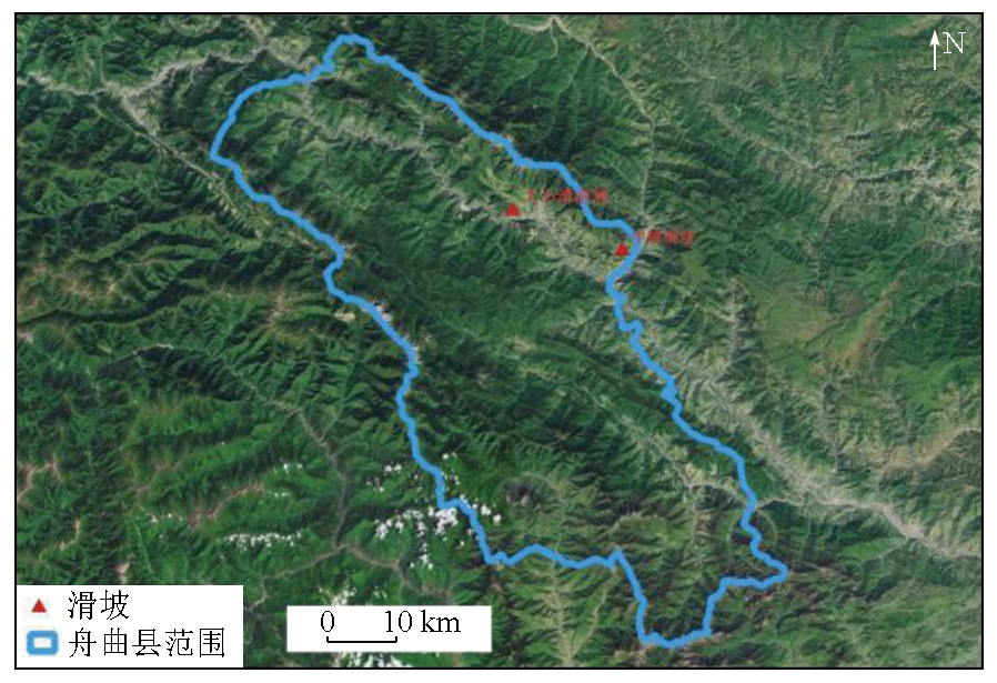
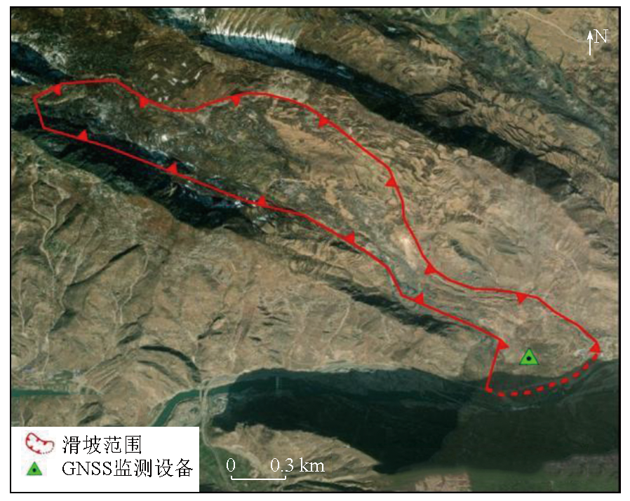
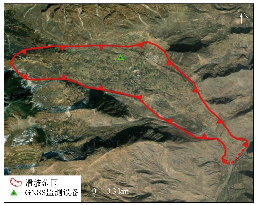
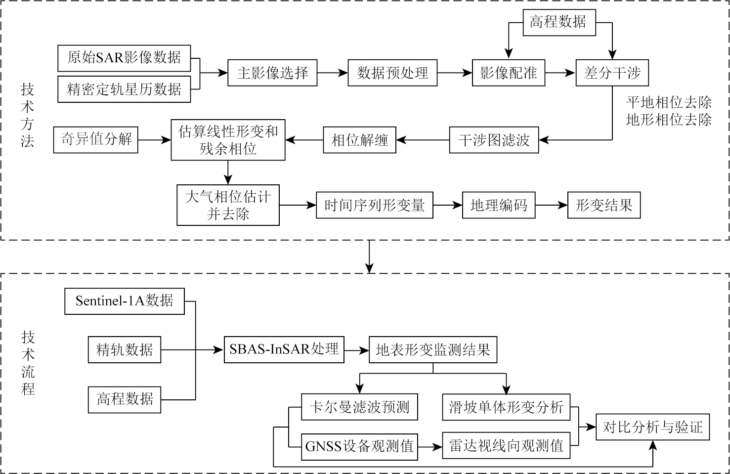
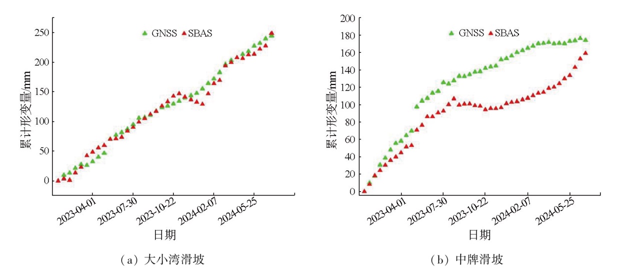
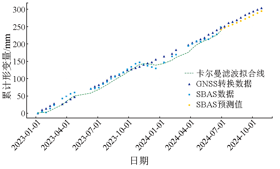
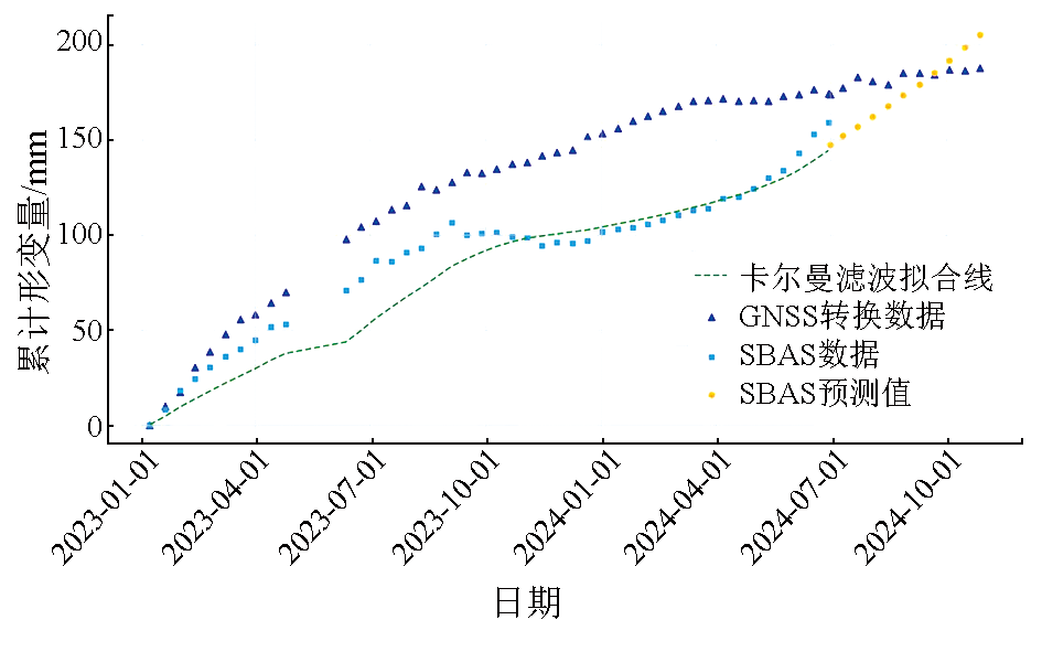
Abstract Given its all-day availability, all-weather adaptability, and high spatial resolution, the interferometric synthetic aperture radar (InSAR) technique has been widely applied in multiple fields, demonstrating strong adaptability and high practical value. Focusing on two typical landslide areas in Zhouqu County, Gansu Province, this study compared small baseline subset InSAR (SBAS-InSAR) monitoring results and Kalman filter prediction results with monitoring data from the global navigation satellite system (GNSS), confirming the reliability and accuracy of the SBAS-InSAR technique in monitoring landslide deformations. The results indicate that the SBAS-InSAR technique exhibited significant advantages in monitoring areas with deformations induced by geologic disasters, effectively overcoming the limitations of traditional monitoring means. This technique can provide critical technical support and scientific basis for early warning and management of geologic disasters in Zhouqu County and other areas prone to suffer these disasters.
|
| Keywords
Zhouqu County
small baseline subset-interferometric synthetic aperture radar (SBAS-InSAR) technology
monitoring data from global navigation satellite system (GNSS)
deformation monitoring
geologic disaster
|
|
|
|
Issue Date: 31 December 2025
|
|
|
| [1] |
许才军, 何平, 温扬茂, 等. InSAR技术及应用研究进展[J]. 测绘地理信息, 2015, 40(2):1-9.
|
| [1] |
Xu C J, He P, Wen Y M, et al. Recent advances in SAR interferometry and its applications[J]. Journal of Geomatics, 2015, 40(2):1-9.
|
| [2] |
刘国祥, 刘文熙, 黄丁发. InSAR技术及其应用中的若干问题[J]. 测绘通报, 2001(8):10-12.
|
| [2] |
Liu G X, Liu W X, Huang D F. InSAR technology and its key problems in applications[J]. Bulletin of Surveying and Mapping, 2001(8):10-12.
|
| [3] |
刘一良. 微波遥感的发展与应用[J]. 沈阳工程学院学报(自然科学版), 2008, 4(2):171-173.
|
| [3] |
Liu Y L. The development and application of microwave sensing[J]. Journal of Shenyang Institute of Engineering (Natural Science), 2008, 4(2):171-173.
|
| [4] |
姜景山, 张云华, 董晓龙. 微波遥感若干前沿技术及新一代空间遥感方法探讨[J]. 中国工程科学, 2000, 2(8):76-82.
|
| [4] |
Jiang J S, Zhang Y H, Dong X L. The discussion of up to date technologies in microwave remote sensing and the new generation of space remote sensing method[J]. Engineering Science, 2000, 2(8):76-82.
|
| [5] |
陈冉丽, 王红军, 刁鑫鹏, 等. InSAR形变监测在开采沉陷损害鉴定及稳定性评价中的应用[J]. 测绘通报, 2023(12):106-111.
doi: 10.13474/j.cnki.11-2246.2023.0367
|
| [5] |
Chen R L, Wang H J, Diao X P, et al. Application of InSAR deformation monitoring in mining subsidence damage identification and stability evaluation[J]. Bulletin of Surveying and Mapping, 2023(12):106-111.
doi: 10.13474/j.cnki.11-2246.2023.0367
|
| [6] |
Li Z, Zhou J, Tian B. The glacier movement estimation and analysis with InSAR in the Qinghai-Tibetan Plateau[C]// 2009 IEEE International Geoscience and Remote Sensing Symposium. July 12-17,2009, Cape Town,South Africa.IEEE, 2009:II-578-II-581.
|
| [7] |
刘菲, 陈蜜, 朱琳, 等. 采用升降轨Sentinel-1数据监测北京城市副中心地面沉降[J]. 地理信息世界, 2021, 28(6):44-52.
|
| [7] |
Liu F, Chen M, Zhu L, et al. Monitoring the land subsidence of Beijing City sub-center with ascending and descending Sentinel-1 data[J]. Geomatics World, 2021, 28(6):44-52.
|
| [8] |
Kubanek J, Westerhaus M, Schenk A, et al. Volumetric change quantification of the 2010 Merapi eruption using TanDEM-X InSAR[J]. Remote Sensing of Environment, 2015,164:16-25.
|
| [9] |
Massonnet D, Rossi M, Carmona C, et al. The displacement field of the Landers earthquake mapped by radar interferometry[J]. Nature, 1993, 364(6433):138-142.
doi: 10.1038/364138a0
|
| [10] |
许才军, 林敦灵, 温扬茂. 利用InSAR数据的汶川地震形变场提取及分析[J]. 武汉大学学报(信息科学版), 2010, 35(10):1138-1142,1261-1262.
|
| [10] |
Xu C J, Lin D L, Wen Y M. Extract and analysis surface deformation caused by Wenchuan Mw7.9 earthquake from InSAR data[J]. Geomatics and Information Science of Wuhan University, 2010, 35(10):1138-1142,1261-1262.
|
| [11] |
屈春燕, 张桂芳, 单新建, 等. 2010年青海玉树地震同震-震后形变场特征及演化过程[J]. 地球物理学报, 2013, 56(7):2280-2291.
|
| [11] |
Qu C Y, Zhang G F, Shan X J, et al. Coseismic and postseismic deformation fields of the 2010 Yushu,Qinghai MS7.1 earthquake and their evolution processes[J]. Chinese Journal of Geophysics, 2013, 56(7):2280-2291.
|
| [12] |
刘振江, 韩炳权, 能懿菡, 等. InSAR观测约束下的2023年甘肃积石山地震震源参数及其滑动分布[J]. 武汉大学学报(信息科学版), 2025, 50(2):344-355.
|
| [12] |
Liu Z J, Han B Q, Neng Y H, et al. Source parameters and slip distribution of the 2023 mW 6.0 Jishishan(Gansu,China) earthquake constrained by InSAR observations[J]. Geomatics and Information Science of Wuhan University, 2025, 50(2):344-355.
|
| [13] |
Fruneau B, Achache J, Delacourt C. Observation and modelling of the Saint-Étienne-de-Tinée landslide using SAR interferometry[J]. Tectonophysics, 1996, 265(3/4):181-190.
doi: 10.1016/S0040-1951(96)00047-9
url: https://linkinghub.elsevier.com/retrieve/pii/S0040195196000479
|
| [14] |
代聪, 李为乐, 陆会燕, 等. 甘肃省舟曲县城周边活动滑坡InSAR探测[J]. 武汉大学学报(信息科学版), 2021, 46(7):994-1002.
|
| [14] |
Dai C, Li W L, Lu H Y, et al. Active landslides detection in Zhouqu County,Gansu Province using InSAR technology[J]. Geomatics and Information Science of Wuhan University, 2021, 46(7):994-1002.
|
| [15] |
丁宏伟. 甘肃省舟曲地质灾害发育特征及典型地质灾害剖析[J]. 甘肃地质, 2012, 21(1):47-53.
|
| [15] |
Ding H W. Characteristics of typical geological disasters in Zhouqu County of Gansu Province[J]. Gansu Geology, 2012, 21(1):47-53.
|
| [16] |
俞晶星, 郑文俊, 袁道阳, 等. 西秦岭西段光盖山-迭山断裂带坪定-化马断裂的新活动性与滑动速率[J]. 第四纪研究, 2012, 32(5):957-967.
|
| [16] |
Yu J X, Zheng W J, Yuan D Y, et al. Late quaternary active characteristics and slip-rate of pingdinghuama fault,the eastern segment of Guanggaishan-dieshan fault zone(west Qinling mountain)[J]. Quaternary Sciences, 2012, 32(5):957-967.
|
| [17] |
李媛茜, 张毅, 孟兴民, 等. 活动构造断裂带巨型滑坡活动特性研究——以白龙江流域大小湾滑坡为例[J]. 兰州大学学报(自然科学版), 2021, 57(3):360-368.
|
| [17] |
Li Y X, Zhang Y, Meng X M, et al. Analysis the activity characteristics of the giant landslide in active tectonic fault zone:A case study of Daxiaowan landslide in Bailong River Basin[J]. Journal of Lanzhou University (Natural Sciences), 2021, 57(3):360-368.
|
| [18] |
杨为民, 黄晓, 张春山, 等. 白龙江流域坪定—化马断裂带滑坡特征及其形成演化[J]. 吉林大学学报(地球科学版), 2014, 44(2):574-583.
|
| [18] |
Yang W M, Huang X, Zhang C S, et al. Deformation behavior of landslides and their formation mechanism along Pingding-Huama active fault in Bailongjiang River Region[J]. Journal of Jilin University (Earth Science Edition), 2014, 44(2):574-583.
|
| [19] |
杨为民, 黄晓, 张永双, 等. 甘肃南部坪定-化马断裂带滑坡变形特征及其防治[J]. 地质通报, 2013, 32(12):1925-1935.
|
| [19] |
Yang W M, Huang X, Zhang Y S, et al. The deformation characteristics of the landslide along Pingding-Huama active fault zone and its prevention and control[J]. Geological Bulletin of China, 2013, 32(12):1925-1935.
|
| [20] |
刘斌, 张丽, 李曼, 等. 融合CR和GNSS的InSAR滑坡形变时序监测方法和存储介质:中国,CN117761716A[P].2024-03-26.
|
| [20] |
Liu B, Zhang L, Li M, et al. InSAR landslide deformation time sequence monitoring method fusing CR and GNSS and storage medium:China,CN117761716A[P].2024-03-26.
|
| [21] |
Lu F, Zeng H. Application of Kalman filter model in the landslide deformation forecast[J]. Scientific Reports, 2020, 10(1):1028.
doi: 10.1038/s41598-020-57881-3
pmid: 31974439
|
| [22] |
周小龙, 石鹏卿. 基于SBAS-InSAR技术的甘肃华亭市地表形变监测与分析[J]. 测绘与空间地理信息, 2023, 46(2):30-33,38.
|
| [22] |
Zhou X L, Shi P Q. Monitoring and analysis of surface deformation in Huating City,Gansu Province based on SBAS-InSAR technology[J]. Geomatics & Spatial Information Technology, 2023, 46(2):30-33,38.
|
| [23] |
姜德才, 郑向向, 王宁, 等. 时序InSAR技术在珠三角地区地质灾害隐患识别中的应用[J]. 自然资源遥感, 2023, 35(3):292-301.doi:10.6046/zrzyyg.2022190.
|
| [23] |
Jiang D C, Zheng X X, Wang N, et al. Application of the time-series InSAR technology in the identification of geological hazards in the Pearl River Delta region[J]. Remote Sensing for Natural Resources, 2023, 35(3):292-301.doi:10.6046/zrzyyg.2022190.
|
| [24] |
Berardino P, Fornaro G, Lanari R, et al. A new algorithm for surface deformation monitoring based on small baseline differential SAR interferograms[J]. IEEE Transactions on Geoscience and Remote Sensing, 2002, 40(11):2375-2383.
doi: 10.1109/TGRS.2002.803792
url: http://ieeexplore.ieee.org/document/1166596/
|
|
Viewed |
|
|
|
Full text
|
|
|
|
|
Abstract
|
|
|
|
|
Cited |
|
|
|
|
| |
Shared |
|
|
|
|
| |
Discussed |
|
|
|
|
 2025,
Vol. 37
2025,
Vol. 37