|
|
|
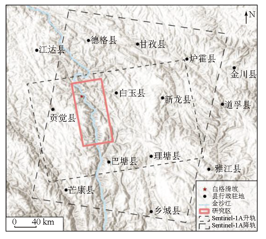
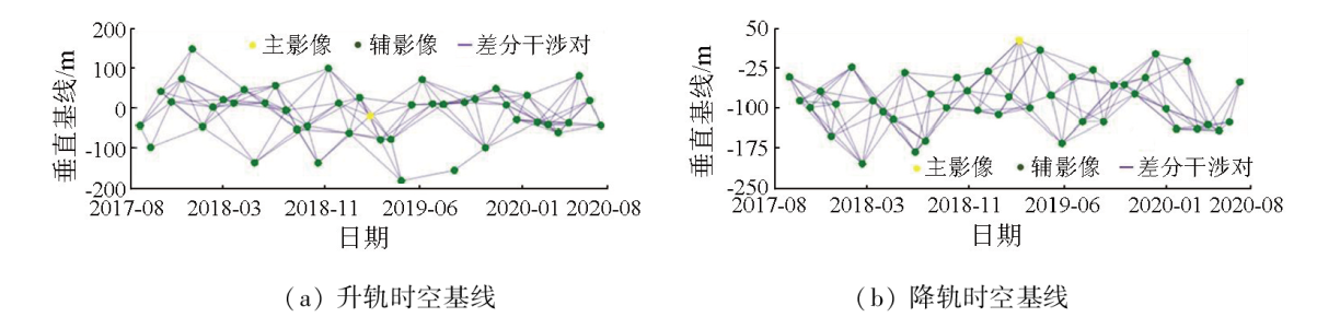
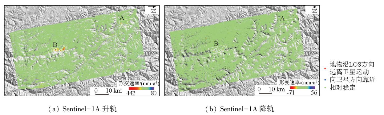
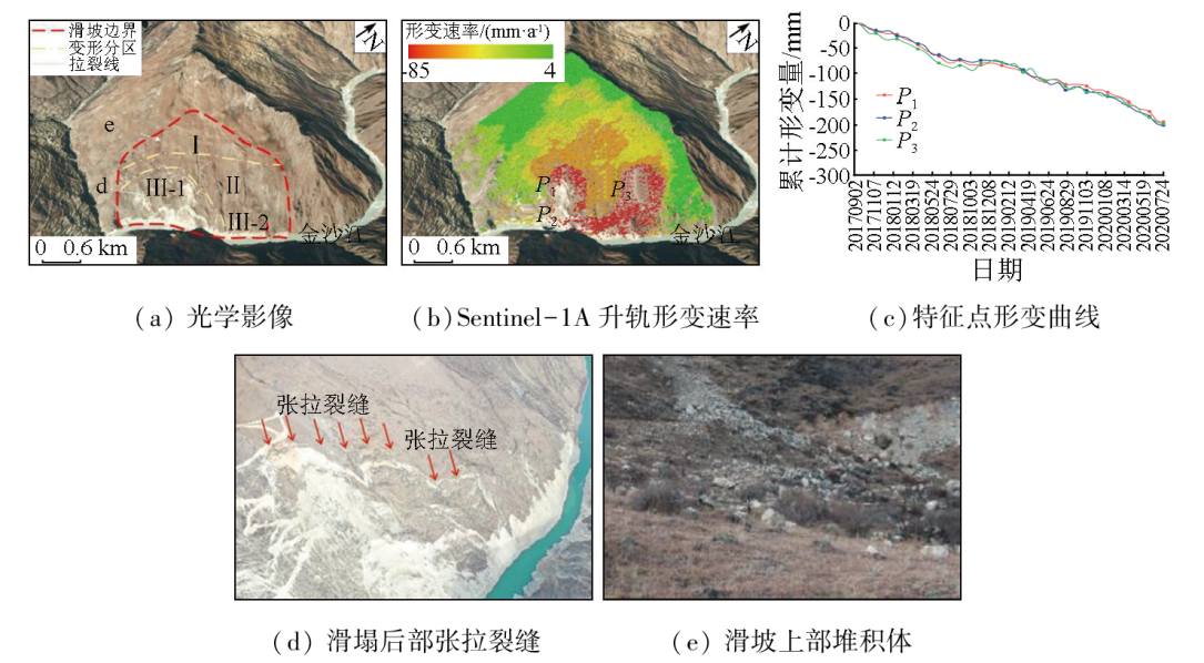
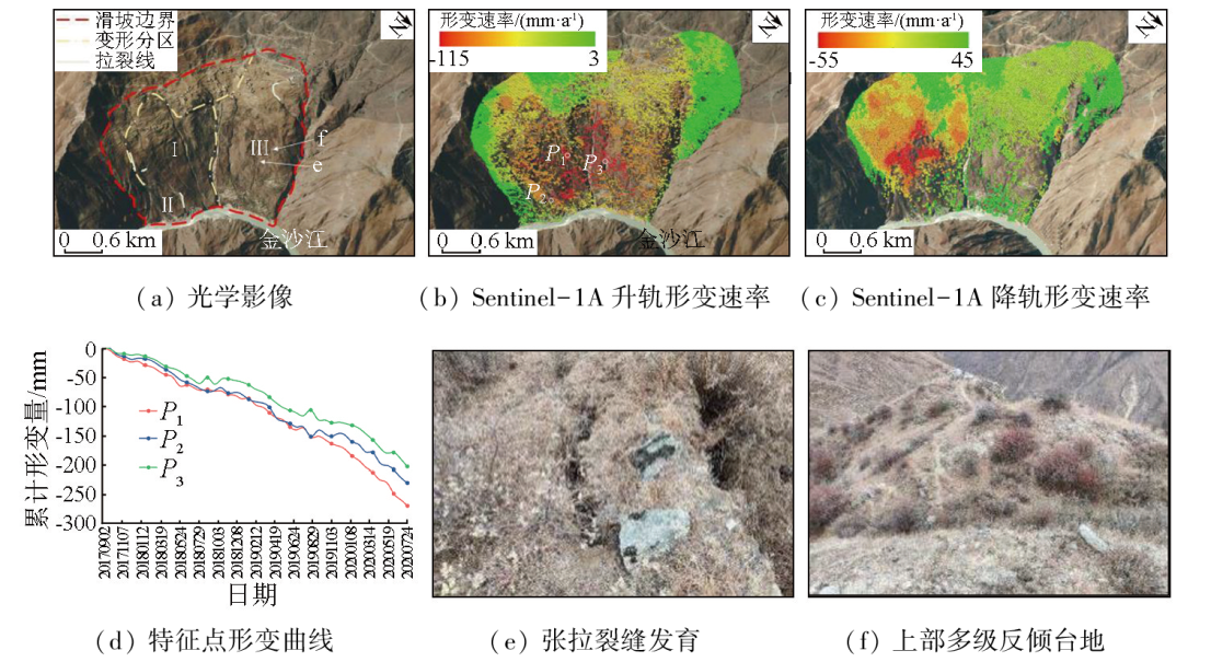
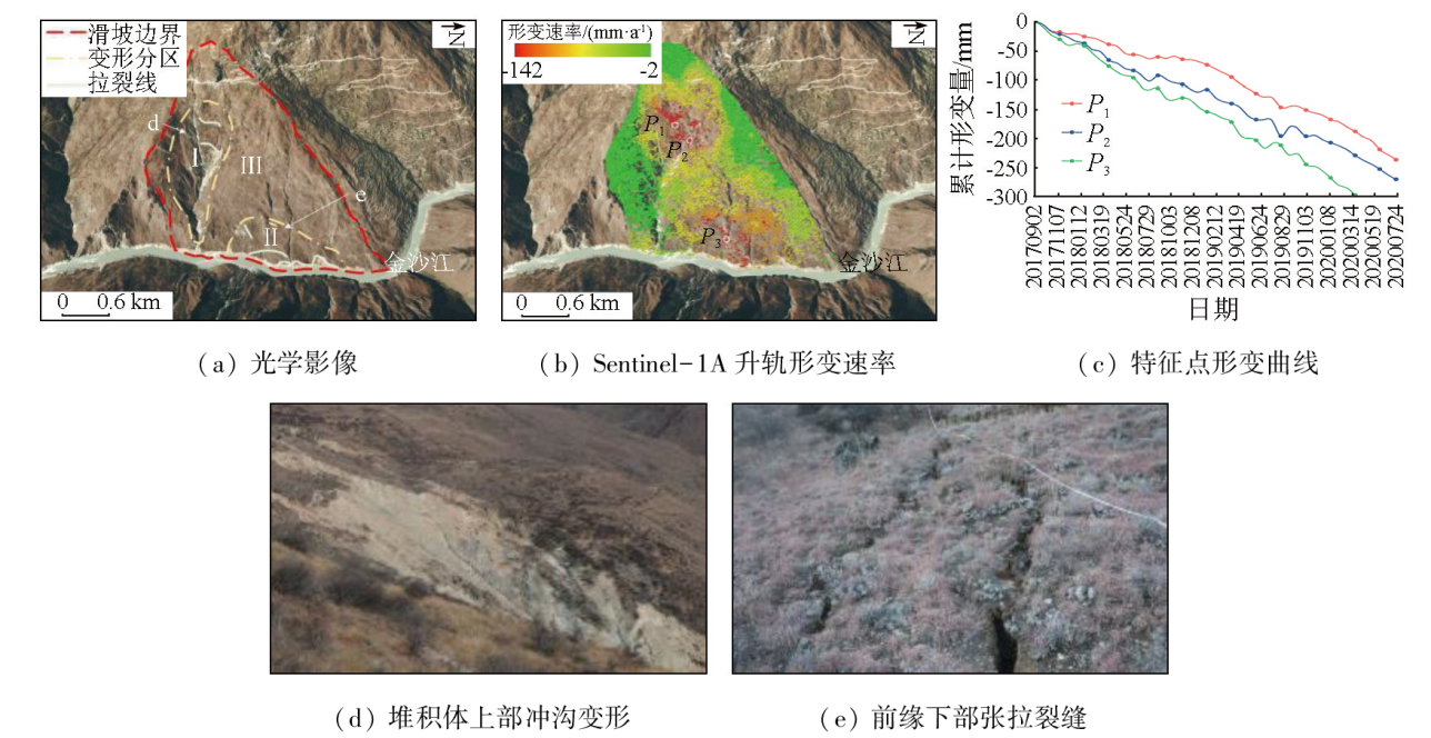
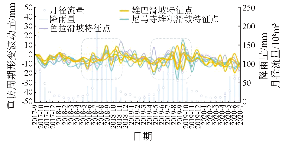
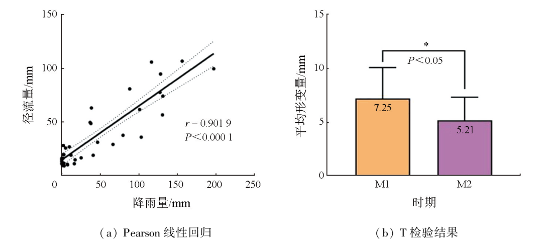
Abstract The Jinsha River basin is a typical area with a high incidence of geologic hazards in China. To accurately identify the potential landslide hazards in the basin, this study processed the data of Sentinel-1A’s ascending and descending orbits using the SBAS-InSAR technique. From two detection directions, it conducted early landslide identification and deformation monitoring of the Baige landslide on the bank of the Jinsha River and its lower reaches covering approximately 100 km. The results show that: ① The combined detection based on Sentinel-1A’s ascending and descending orbits effectively reduced the interference of geometric distortions, enabling the identification of long-term creep hazard sites; ② The deformation rates along the line-of-sight (LOS) of ascending and descending orbits ranged from -142 to 80 mm/a and -71 to 56 mm/a, respectively. Combined with the visual interpretation of optical remote sensing images, two large landslide clusters consisting of nine landslides were detected; ③ The analysis of surface deformation characteristics was conducted on three typical landslides: the Sela landslide, the Shadong (Xiongba) landslide, and the Nimasi talus slide. The analysis results reveal that the maximum deformation was associated with the peak rainfall and river runoff, which constituted the significant factors influencing landslide deformation. The results of this study serve as a reference for the prediction, early warning, prevention, and control of basin-scale geologic hazards in flood seasons.
|
| Keywords
Jinsha River
landslide hazard
deformation monitoring
SBAS-InSAR
|
|
|
|
Issue Date: 03 September 2024
|
|
|
| [1] |
黄润秋, 许强, 邓辉, 等. 中国典型灾难性滑坡[M]. 北京: 科学出版社, 2008:553.
|
| [1] |
Huang R Q, Xu Q, Deng H, et al. Catastrophic landslides in China[M]. Beijing: Science Press, 2008:553.
|
| [2] |
Zhao C Y, Kang Y, Zhang Q, et al. Landslide identification and monitoring along the Jinsha River catchment (Wudongde reservoir area),China,using the InSAR method[J]. Remote Sensing, 2018, 10(7):993.
|
| [3] |
许强, 董秀军, 李为乐. 基于天-空-地一体化的重大地质灾害隐患早期识别与监测预警[J]. 武汉大学学报(信息科学版), 2019, 44(7):957-966.
|
| [3] |
Xu Q, Dong X J, Li W L. Integrated space-air-ground early detection,monitoring and warning system for potential catastrophic geohazards[J]. Geomatics and Information Science of Wuhan University, 2019, 44(7):957-966.
|
| [4] |
Berardino P, Fornaro G, Lanari R, et al. A new algorithm for surface deformation monitoring based on small baseline differential SAR interferograms[J]. IEEE Transactions on Geoscience and Remote Sensing, 2002, 40(11):2375-2383.
|
| [5] |
朱建军, 李志伟, 胡俊. InSAR变形监测方法与研究进展[J]. 测绘学报, 2017, 46(10):1717-1733.
doi: 10.11947/j.AGCS.2017.20170350
|
| [5] |
Zhu J J, Li Z W, Hu J. Research progress and methods of InSAR for deformation monitoring[J]. Acta Geodaetica et Cartographica Sinica, 2017, 46(10):1717-1733.
doi: 10.11947/j.AGCS.2017.20170350
|
| [6] |
李晓恩, 周亮, 苏奋振, 等. InSAR技术在滑坡灾害中的应用研究进展[J]. 遥感学报, 2021, 25(2):614-629.
|
| [6] |
Li X E, Zhou L, Su F Z, et al. Application of InSAR technology in landslide hazard:Progress and prospects[J]. National Remote Sensing Bulletin, 2021, 25(2):614-629.
|
| [7] |
许强. 对地质灾害隐患早期识别相关问题的认识与思考[J]. 武汉大学学报(信息科学版), 2020, 45(11):1651-1659.
|
| [7] |
Xu Q. Understanding and consideration of related issues in early identification of potential geohazards[J]. Geomatics and Information Science of Wuhan University, 2020, 45(11):1651-1659.
|
| [8] |
Hussain S, Pan B, Afzal Z, et al. Landslide detection and inventory updating using the time-series InSAR approach along the Karakoram Highway,Northern Pakistan[J]. Scientific Reports, 2023, 13(1):7485.
doi: 10.1038/s41598-023-34030-0
pmid: 37161025
|
| [9] |
何秀凤. 变形监测新方法及其应用[M]. 北京: 科学出版社, 2007.
|
| [9] |
He X F. New deformation monitoring method and its application[M]. Beijing: Science Press, 2007.
|
| [10] |
刘莉, 张丽萍, 李萍, 等. 金沙江巧家巨型古滑坡发育特征及其形成条件[J]. 人民长江, 2022, 53(1):118-125.
|
| [10] |
Liu L, Zhang L P, Li P, et al. Development characteristics and forming conditions of Qiaojia giant ancient landslide in Jinsha River[J]. Yangtze River, 2022, 53(1):118-125.
|
| [11] |
陈剑, 崔之久, 陈瑞琛, 等. 金沙江上游特米古滑坡堰塞湖成因与演化[J]. 地学前缘, 2021, 28(2):85-93.
doi: 10.13745/j.esf.sf.2020.9.9
|
| [11] |
Chen J, Cui Z J, Chen R C, et al. The origin and evolution of the Temi paleolandslide-dammed lake in the upper Jinsha River[J]. Earth Science Frontiers, 2021, 28(2):85-93.
doi: 10.13745/j.esf.sf.2020.9.9
|
| [12] |
Wang P, Chen J, Dai F, et al. Chronology of relict lake deposits around the Suwalong paleolandslide in the upper Jinsha River,SE Tibetan Plateau:Implications to Holocene tectonic perturbations[J]. Geomorphology, 2014, 217:193-203.
|
| [13] |
董岳, 丁明涛, 李鑫泷, 等. 基于光学遥感像素偏移量的金沙江流域2018年白格滑坡演变过程[J]. 地球科学与环境学报, 2022, 44(6):1002-1015.
|
| [13] |
Dong Y, Ding M T, Li X L, et al. Evolution of the 2018 Baige landslides revealed by optical remote sensing pixel offsets in Jinsha River basin,China[J]. Journal of Earth Sciences and Environment, 2022, 44(6):1002-1015.
|
| [14] |
许强, 郑光, 李为乐, 等. 2018年10月和11月金沙江白格两次滑坡-堰塞堵江事件分析研究[J]. 工程地质学报, 2018, 26(6):1534-1551.
|
| [14] |
Xu Q, Zheng G, Li W L, et al. Study on successive landslide damming events of Jinsha River in Baige Village on Octorber 11 and November 3,2018[J]. Journal of Engineering Geology, 2018, 26(6):1534-1551.
|
| [15] |
戴可人, 张乐乐, 宋闯, 等. 青藏高原交通廊道沿线Sentinel-1影像几何畸变与升降轨适宜性定量分析[J]. 武汉大学学报(信息科学版), 2021, 46(10):1450-1460.
|
| [15] |
Dai K R, Zhang L L, Song C, et al. Quantitative analysis of Sentinel-1 imagery geometric distortion and their suitability along Qinghai-Tibet plateau traffic corridor[J]. Geomatics and Information Science of Wuhan University, 2021, 46(10):1450-1460.
|
| [16] |
戴可人, 铁永波, 许强, 等. 高山峡谷区滑坡灾害隐患InSAR早期识别——以雅砻江中段为例[J]. 雷达学报, 2020, 9(3):554-568.
|
| [16] |
Dai K R, Tie Y B, Xu Q, et al. Early identification of potential landslide geohazards in alpine-canyon terrain based on SAR interferometry:A case study of the middle section of Yalong River[J]. Journal of Radars, 2020, 9(3):554-568.
|
| [17] |
李振洪, 宋闯, 余琛, 等. 卫星雷达遥感在滑坡灾害探测和监测中的应用:挑战与对策[J]. 武汉大学学报(信息科学版), 2019, 44(7):967-979.
|
| [17] |
Li Z H, Song C, Yu C, et al. Application of satellite radar remote sensing to landslide detection and monitoring:challenges and solutions[J]. Geomatics and Information Science of Wuhan University, 2019, 44(7):967-979.
|
| [18] |
闫怡秋, 郭长宝, 张永双, 等. 基于SBAS-InSAR技术的西藏雄巴古滑坡变形特征[J]. 地质学报, 2021, 95(11):3556-3570.
|
| [18] |
Yan Y Q, Guo C B, Zhang Y S, et al. Study of the deformation characteristics of the Xiongba ancient landslide based on SBAS-InSAR method,Tibet,China[J]. Acta Geologica Sinica, 2021, 95(11):3556-3570.
|
| [19] |
张路, 廖明生, 董杰, 等. 基于时间序列InSAR分析的西部山区滑坡灾害隐患早期识别——以四川丹巴为例[J]. 武汉大学学报(信息科学版), 2018, 43(12):2039-2049.
|
| [19] |
Zhang L, Liao M S, Dong J, et al. Early detection of landslide hazards in mountainous areas of west China using time series SAR interferometry:A case study of Danba,Sichuan[J]. Geomatics and Information Science of Wuhan University, 2018, 43(12):2039-2049.
|
| [20] |
Ran P, Li S D, Zhuo G C, et al. Early identification and influencing factors analysis of active landslides in mountainous areas of southwest China using SBAS-InSAR[J]. Sustainability, 2023, 15(5):4366.
|
| [21] |
孙倩, 胡俊, 陈小红. 多时相InSAR技术及其在滑坡监测中的关键问题分析[J]. 地理与地理信息科学, 2019, 35(3):37-45.
|
| [21] |
Sun Q, Hu J, Chen X H. Multi-temporal InSAR techniques and their challenges in the landslides monitoring[J]. Geography and Geo-Information Science, 2019, 35(3):37-45.
|
| [22] |
周定义, 左小清, 喜文飞, 等. 基于SBAS-InSAR技术的深切割高山峡谷区滑坡灾害早期识别[J]. 中国地质灾害与防治学报, 2022, 33(2):16-24.
|
| [22] |
Zhou D Y, Zuo X Q, Xi W F, et al. Early identification of landslide hazards in deep cut alpine canyon using SBAS-InSAR technology[J]. The Chinese Journal of Geological Hazard and Control, 2022, 33(2):16-24.
|
| [23] |
孙永彬, 张恩, 李启亮, 等. 金沙江下游永善段隐蔽性滑坡隐患综合遥感识别[J]. 工程科学与技术, 2023, 55(1):171-183.
|
| [23] |
Sun Y B, Zhang E, Li Q L, et al. Comprehensive remote sensing identification of hidden landslides in Yongshan section of lower Jinsha River[J]. Advanced Engineering Sciences, 2023, 55(1):171-183.
|
| [24] |
陆会燕, 李为乐, 许强, 等. 光学遥感与InSAR结合的金沙江白格滑坡上下游滑坡隐患早期识别[J]. 武汉大学学报(信息科学版), 2019, 44(9):1342-1354.
|
| [24] |
Lu H Y, Li W L, Xu Q, et al. Early detection of landslides in the upstream and downstream areas of the Baige landslide,the Jinsha River based on optical remote sensing and InSAR technologies[J]. Geomatics and Information Science of Wuhan University, 2019, 44(9):1342-1354.
|
| [25] |
朱赛楠, 殷跃平, 王猛, 等. 金沙江结合带高位远程滑坡失稳机理及减灾对策研究——以金沙江色拉滑坡为例[J]. 岩土工程学报, 2021, 43(4):688-697.
|
| [25] |
Zhu S N, Yin Y P, Wang M, et al. Instability mechanism and disaster mitigation measures of long-distance landslide at high location in Jinsha River junction zone:A case study of Sela landslide in Jinsha River,Tibet[J]. Chinese Journal of Geotechnical Engineering, 2021, 43(4):688-697.
|
| [26] |
李振洪, 张成龙, 陈博, 等. 一种基于多源遥感的滑坡防灾技术框架及其工程应用[J]. 地球科学, 2022, 47(6):1901-1916.
|
| [26] |
Li Z H, Zhang C L, Chen B, et al. A technical framework of landslide prevention based on multi-source remote sensing and its engineering application[J]. Earth Science, 2022, 47(6):1901-1916.
|
| [27] |
Gou Y T, Zhang L, Chen Y, et al. Monitoring seasonal movement characteristics of the landslide based on time-series InSAR technology:The Cheyiping landslide case study,China[J]. Remote Sensing, 2022, 15(1):51.
|
| [28] |
Wen N, Dai K R, Tomas R, et al. Revealing the time lag between slope stability and reservoir water fluctuation from InSAR observations and wavelet tools:A case study in Maoergai Reservoir (China)[J]. Giscience and Remote Sensing, 2023, 60(1):18.
|
| [29] |
代聪, 李为乐, 陆会燕, 等. 甘肃省舟曲县城周边活动滑坡InSAR探测[J]. 武汉大学学报(信息科学版), 2021, 46(7):994-1002.
|
| [29] |
Dai C, Li W L, Lu H Y, et al. Active landslides detection in Zhouqu County,Gansu Province using InSAR technology[J]. Geomatics and Information Science of Wuhan University, 2021, 46(7):994-1002.
|
| [30] |
Zhang G, Wang S Y, Chen Z W, et al. Landslide susceptibility evaluation integrating weight of evidence model and InSAR results,west of Hubei Province,China[J]. The Egyptian Journal of Remote Sensing and Space Science, 2023, 26(1):95-106.
|
|
Viewed |
|
|
|
Full text
|
|
|
|
|
Abstract
|
|
|
|
|
Cited |
|
|
|
|
| |
Shared |
|
|
|
|
| |
Discussed |
|
|
|
|
 2024,
Vol. 36
2024,
Vol. 36
 ), HAO Lina1(