|
|
 |
|

|
|
|
Monitoring and identification of potential geological hazard sites using comprehensive remote sensing in Ningbo, Zhejiang Province |
GAO Feng1( ), ZHANG Honghuai1, ZHOU Wei2(), WANG Xingxing3, SUN Liying1, XU Wenxin1, WU Di3 ), ZHANG Honghuai1, ZHOU Wei2(), WANG Xingxing3, SUN Liying1, XU Wenxin1, WU Di3 |
1. Ningbo Natural Resources Ecological Restoration and Marine Management Service Center, Ningbo 315000, China
2. Key Laboratory of Digital Earth Science, Chinese Academy of Sciences, Beijing 100094, China
3. Zhejiang Academy of Surveying and Mapping, Hangzhou 311100, China |
|
|
|
|
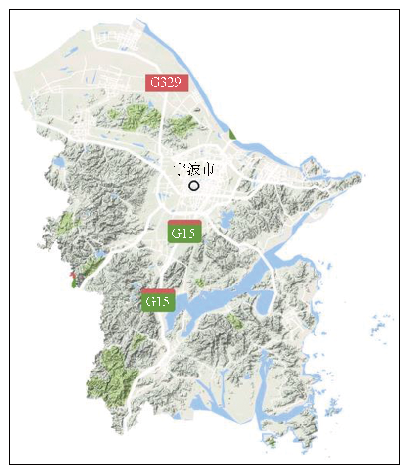
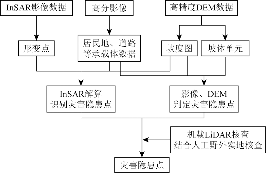
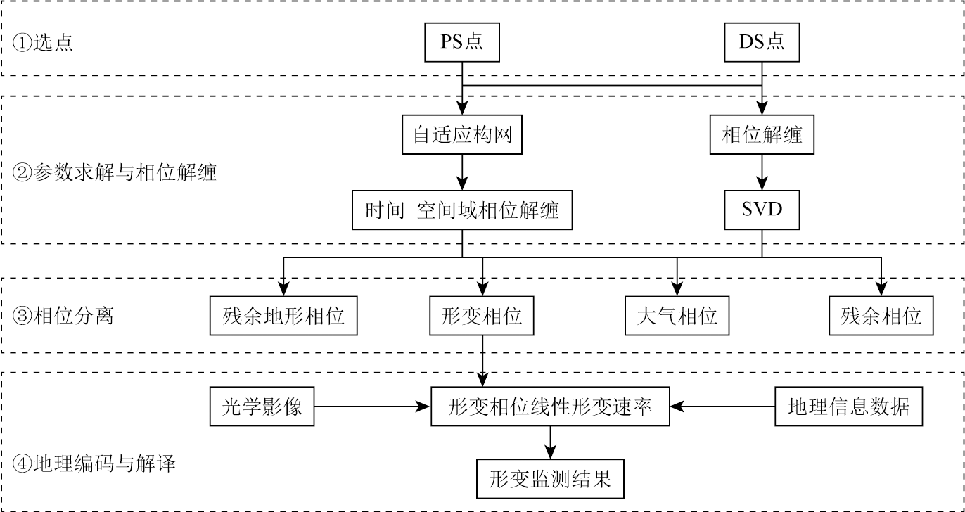
Abstract Ningbo, located in Zhejiang Province along the eastern coast of China, features diverse landforms and a complex geological environment. It is prone to geological hazards such as landslides, rockfalls, and debris flows, particularly during the flood season. Therefore, it is of great importance to conduct surface deformation monitoring in Ningbo for geological hazard prevention and control. This study integrated multiple remote sensing methods, including interferometric synthetic aperture radar (InSAR), high-resolution optical imagery, and unmanned aerial vehicle-based light detection and ranging (LiDAR). On this basis, landslide hazard monitoring was conducted in Ningbo using comprehensive remote sensing, obtaining the distribution of potential geological hazard sites, from which detailed locations and morphological information of typical high-risk slopes were extracted. Moreover, this study employed a combined-multi-temporal InSAR (CMT-InSAR) method, which integrated permanent and distributed scatterers to form a network. This method effectively increased the density of high-coherence points under vegetated hilly conditions, enhancing the coverage and accuracy of deformation monitoring. As indicated by the experimental results, Ningbo exhibited an overall stable land surface. However, local coastal areas showed significant surface deformation due to activities such as land reclamation, with a subsidence rate exceeding -20 mm/a. In mountainous areas, high-risk sites were primarily concentrated in the Fenghua District, Ninghai County, Yuyao City, and Xiangshan County, with some areas featuring annual average surface deformation rates ranging from -20 to -7 mm/a. The deformation inversion results aligned with field survey observations. This study proposes a high-precision, multi-level, and long-term approach for the early identification and monitoring of geological hazards in mountainous and hilly areas.
|
| Keywords
deformation monitoring
interferometric synthetic aperture radar (InSAR)
geological hazard
geological hazard prevention and control in Ningbo
high-resolution optical image
unmanned aerial vehicle-based light detection and ranging (UAV-LiDAR)
|
|
|
|
Issue Date: 31 December 2025
|
|
|
| [1] |
自然资源部. 2024年全国地质灾害防治工作要点[EB/OL]. (2024-04-03)[2024-07-15].https://www.gov.cn/zhengce/zhengceku/202404/content_6944142.htm.
url: https://www.gov.cn/zhengce/zhengceku/202404/content_6944142.htm
|
| [1] |
Ministry of Natural Resources. Key tasks for national geological disaster prevention and control in 2024[EB/OL].(2024-04-03)[2024-07-15].https://www.gov.cn/zhengce/zhengceku/202404/content_6944142.htm.
url: https://www.gov.cn/zhengce/zhengceku/202404/content_6944142.htm
|
| [2] |
Huang G, Du S, Wang D. GNSS techniques for real-time monitoring of landslides: A review[J]. Satellite Navigation, 2023, 4(1): 5.
doi: 10.1186/s43020-023-00095-5
|
| [3] |
王庆国, 赵海, 李健平. 地面激光点云与航空影像相结合的滑坡监测[J]. 测绘通报, 2019(4): 99-102.
doi: 10.13474/j.cnki.11-2246.2019.0122
|
| [3] |
Wang Q G, Zhao H, Li J P. Landslide monitoring by merging ground laser point cloud and aerial image[J]. Bulletin of Surveying and Mapping, 2019(4): 99-102.
doi: 10.13474/j.cnki.11-2246.2019.0122
|
| [4] |
赵瑞英. 三维激光扫描技术在滑坡检测中的应用研究[D]. 兰州: 兰州交通大学, 2017.
|
| [4] |
Zhao R Y. Research about 3D laser scanning technology in landslide monitoring[D]. Lanzhou: Lanzhou Jiatong University, 2017.
|
| [5] |
Hölbling D, Eisank C, Albrecht F, et al. Comparing manual and semi-automated landslide mapping based on optical satellite images from different sensors[J]. Geosciences, 2017, 7(2): 37.
doi: 10.3390/geosciences7020037
url: https://www.mdpi.com/2076-3263/7/2/37
|
| [6] |
Ebrahim K M P, Gomaa S M M H, Zayed T, et al. Recent phenomenal and investigational subsurface landslide monitoring techniques: A mixed review[J]. Remote Sensing, 2024, 16(2): 385.
doi: 10.3390/rs16020385
url: https://www.mdpi.com/2072-4292/16/2/385
|
| [7] |
Tian H, Kou P, Xu Q, et al. Analysis of landslide deformation in eastern Qinghai Province,Northwest China,using SBAS-InSAR[J]. Natural Hazards, 2024, 120(6): 5763-5784.
doi: 10.1007/s11069-024-06442-2
|
| [8] |
Hu M, Ren Y, Xiao L, et al. Landslide monitoring based on GNSS and automated inclinometer systems and dynamic modeling using SPH: A case study in Qinghai,China[J]. Environmental Earth Sciences, 2024, 83(6): 170.
doi: 10.1007/s12665-024-11463-y
|
| [9] |
许强, 董秀军, 李为乐. 基于天-空-地一体化的重大地质灾害隐患早期识别与监测预警[J]. 武汉大学学报(信息科学版), 2019, 44(7): 957-966.
|
| [9] |
Xu Q, Dong X J, Li W L. Integrated space-air-ground early detection,monitoring and warning system for potential catastrophic geohazards[J]. Geomatics and Information Science of Wuhan University, 2019, 44(7): 957-966.
|
| [10] |
葛大庆, 戴可人, 郭兆成, 等. 重大地质灾害隐患早期识别中综合遥感应用的思考与建议[J]. 武汉大学学报(信息科学版), 2019, 44(7): 949-956.
|
| [10] |
Ge D Q, Dai K R, Guo Z C, et al. Early identification of serious geological hazards with integrated remote sensing technologies: Thoughts and recommendations[J]. Geomatics and Information Science of Wuhan University, 2019, 44(7): 949-956.
|
| [11] |
Bellotti F, Bianchi M, Colombo D, et al. Advanced InSAR techniques to support landslide monitoring[C]// Mathematics of Planet Earth.Berlin, Heidelberg: Springer Berlin Heidelberg, 2014: 287-290.
|
| [12] |
宁波市自然资源和规划局. 宁波地质灾害防治十四五规划[EB/OL].(2021-08-09)[2024-07-15].https://fgw.ningbo.gov.cn/art/2021/8/9/art_1229547556_58942159.html.
url: https://fgw.ningbo.gov.cn/art/2021/8/9/art_1229547556_58942159.html
|
| [12] |
Ningbo Municipal Bureau of Natural Resources and Planning. Ningbo Geological Disaster Prevention and Control 14th Five-Year Plan[EB/OL].(2021-08-09)[2024-07-15].https://fgw.ningbo.gov.cn/art/2021/8/9/art_1229547556_58942159.html.
url: https://fgw.ningbo.gov.cn/art/2021/8/9/art_1229547556_58942159.html
|
| [13] |
Ferretti A, Prati C, Rocca F. Permanent scatterers in SAR interferometry[J]. IEEE Transactions on Geoscience and Remote Sensing, 2001, 39(1): 8-20.
doi: 10.1109/36.898661
url: http://ieeexplore.ieee.org/document/898661/
|
| [14] |
Berardino P, Fornaro G, Lanari R, et al. A new algorithm for surface deformation monitoring based on small baseline differential SAR interferograms[J]. IEEE Transactions on Geoscience and Remote Sensing, 2002, 40(11): 2375-2383.
doi: 10.1109/TGRS.2002.803792
url: http://ieeexplore.ieee.org/document/1166596/
|
| [15] |
Zhao C, Li Z, Zhang P, et al. Improved maximum likelihood estimation for optimal phase history retrieval of distributed scatterers in InSAR stacks[J]. IEEE Access, 2019,7: 186319-186327.
|
| [16] |
Colesanti C, Ferretti A, Novali F, et al. SAR monitoring of progressive and seasonal ground deformation using the permanent scatterers technique[J]. IEEE Transactions on Geoscience and Remote Sensing, 2003, 41(7): 1685-1701.
doi: 10.1109/TGRS.2003.813278
url: http://ieeexplore.ieee.org/document/1221835/
|
|
Viewed |
|
|
|
Full text
|
|
|
|
|
Abstract
|
|
|
|
|
Cited |
|
|
|
|
| |
Shared |
|
|
|
|
| |
Discussed |
|
|
|
|
 2025,
Vol. 37
2025,
Vol. 37