|
|
 |
|

|
|
|
2000-2020 spatiotemporal variations of different vegetation types in the Yellow River basin and influencing factors |
WEI Xiao1,2,3( ), ZHANG Lifeng1,2,3(), HE Yi1,2,3, CAO Shengpeng1,2,3, SUN Qiang1,2,3, GAO Binghai1,2,3 ), ZHANG Lifeng1,2,3(), HE Yi1,2,3, CAO Shengpeng1,2,3, SUN Qiang1,2,3, GAO Binghai1,2,3 |
1. School of Surveying and Mapping and Geographic Information, Lanzhou Jiaotong University, Lanzhou 730070, China
2. National and Local Joint Engineering Research Center for Geographic Monitoring Technology Application, Lanzhou 730070, China
3. Engineering Laboratory of Geographic Monitoring of Gansu Province, Lanzhou 730070, China |
|
|
|
|
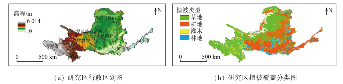
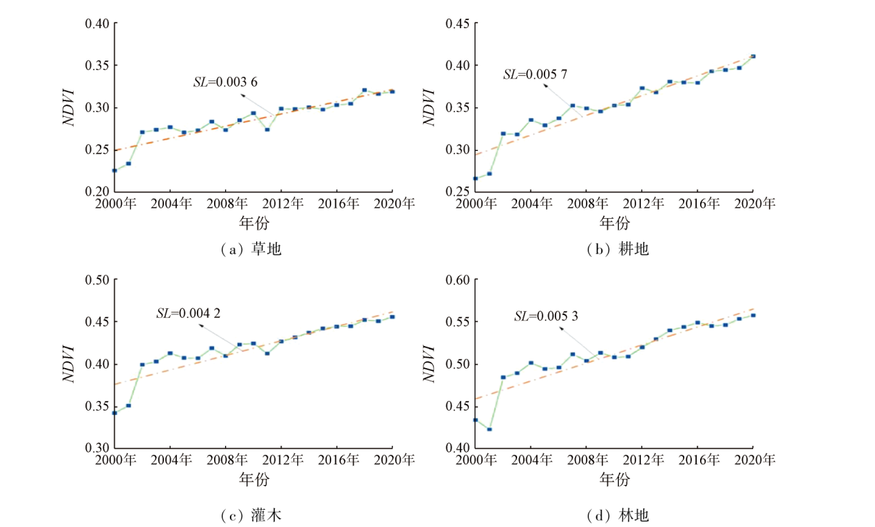
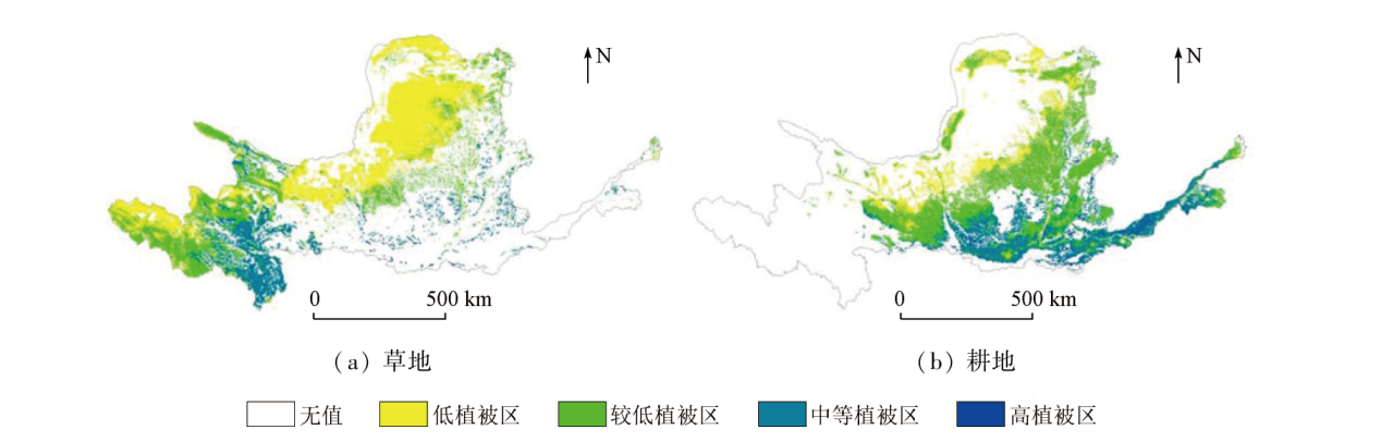
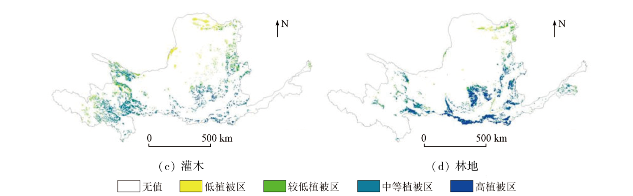
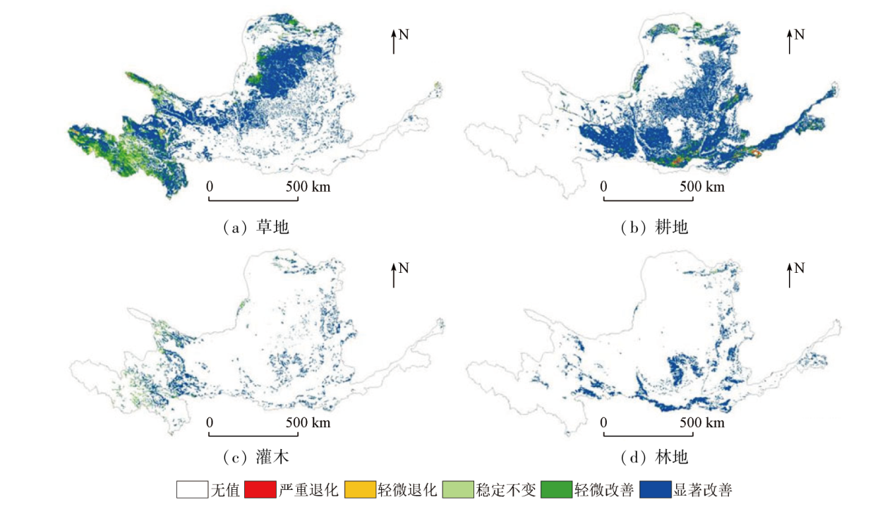
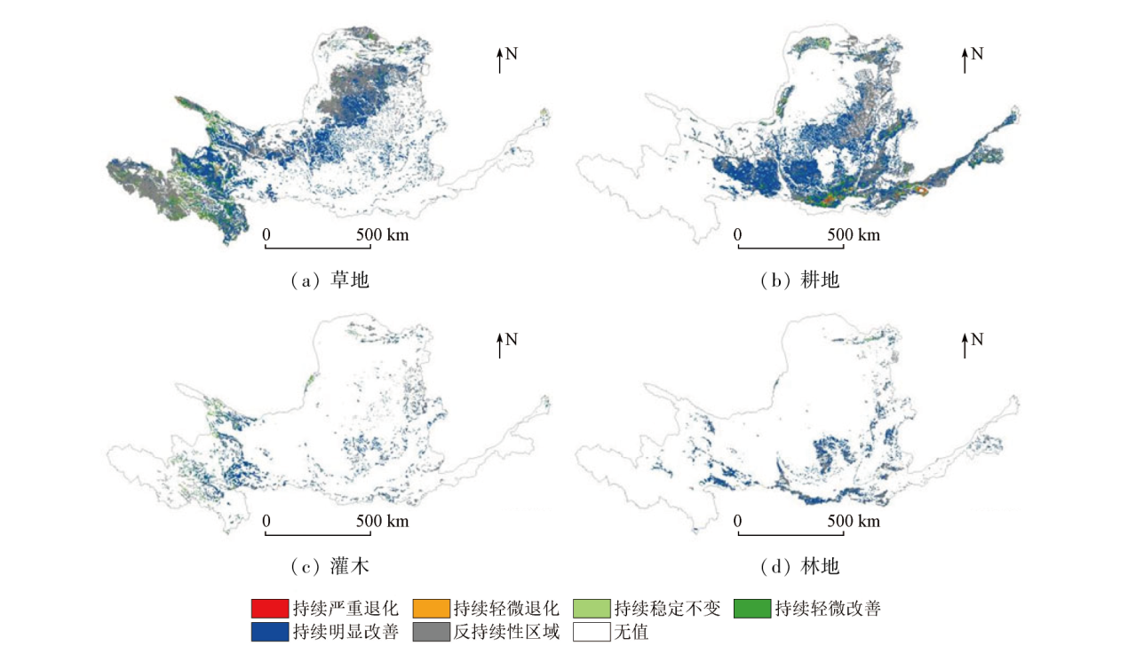
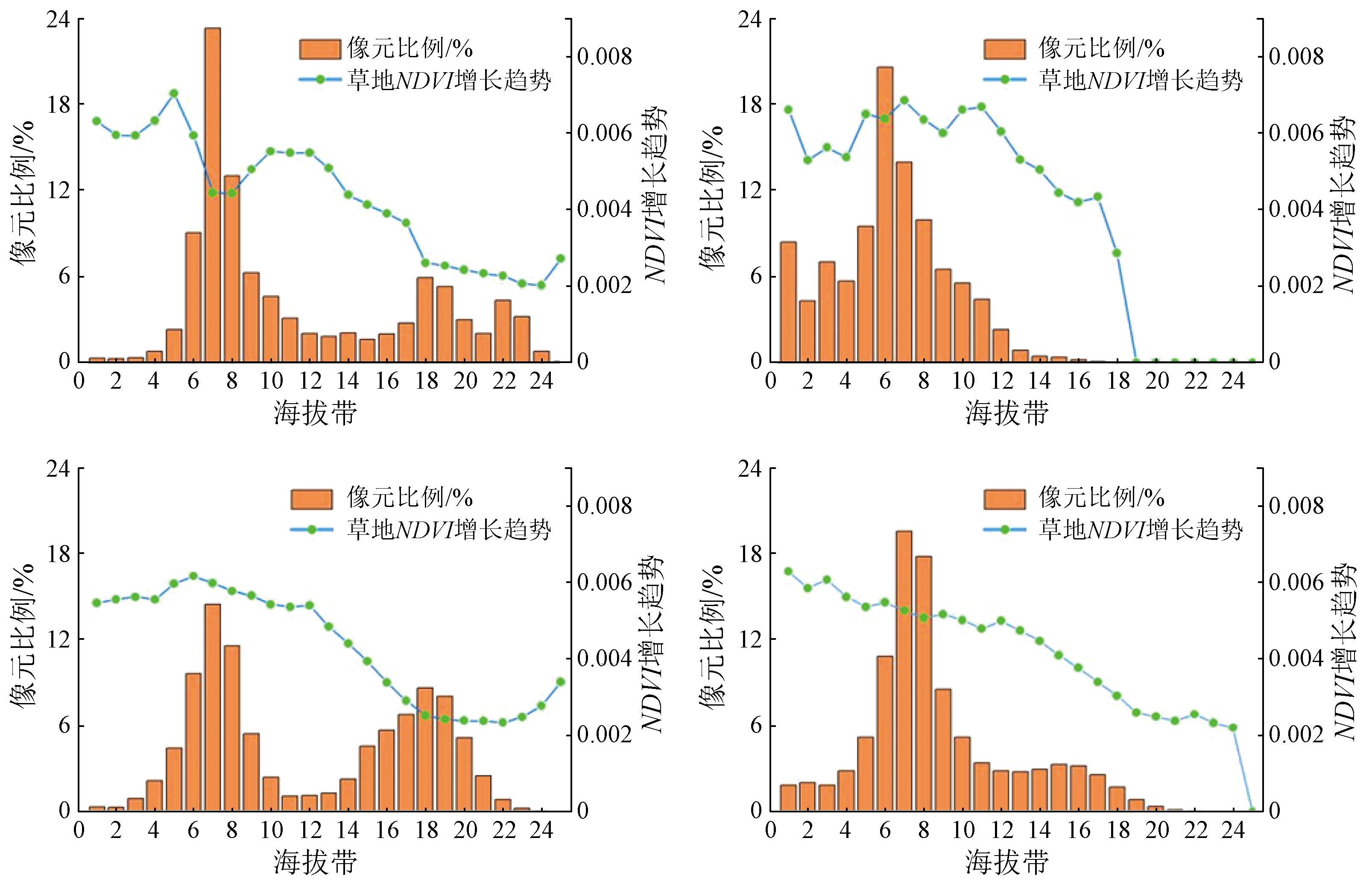
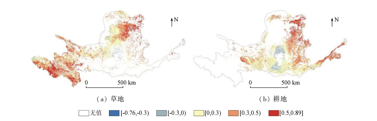
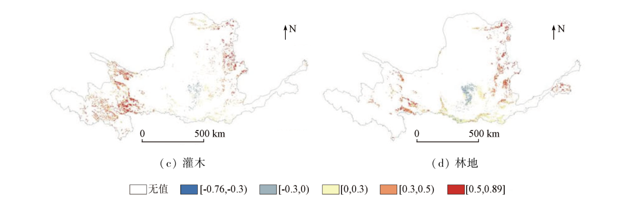
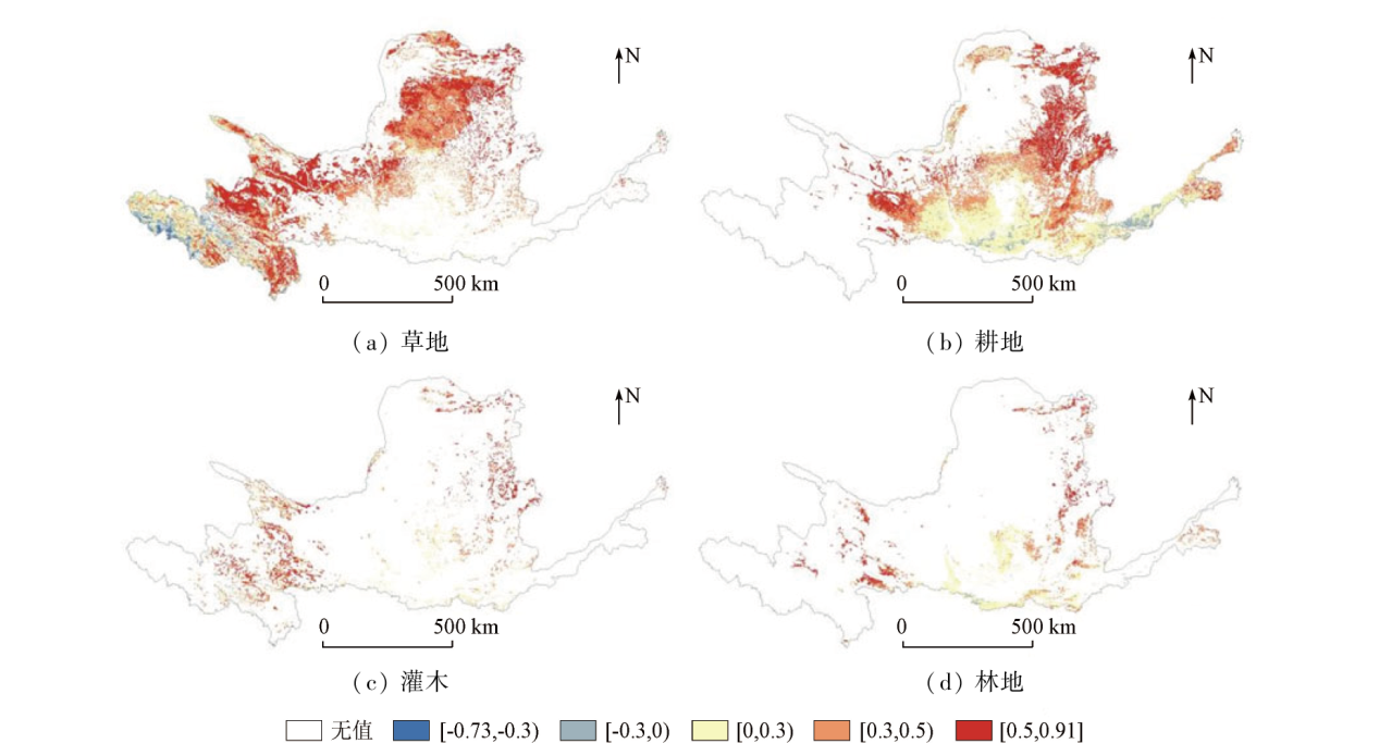
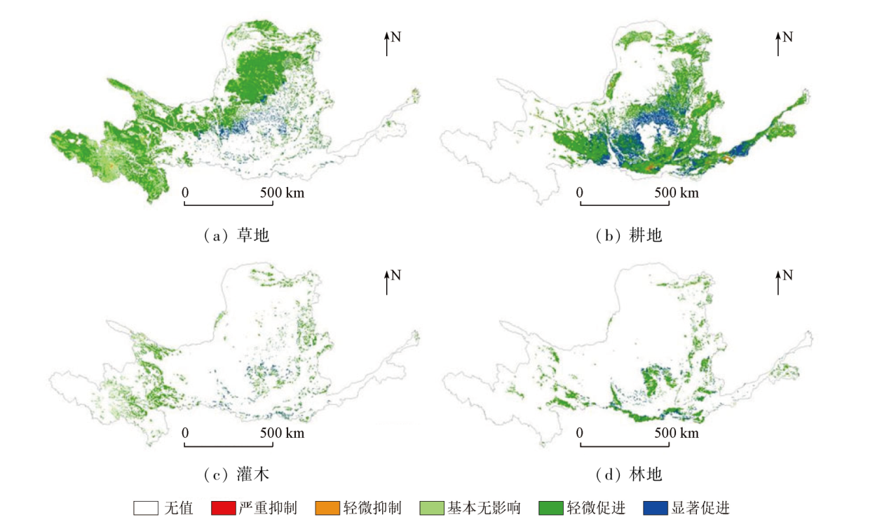
Abstract Understanding the spatiotemporal characteristics of vegetation growth in the Yellow River basin and their influencing factors is crucial for the conservation and development of the ecology. However, existing studies rarely focus on the latest spatiotemporal characteristics of different vegetation types in the basin and their relationships with their influencing factors. Using the 2000-2020 time series remote sensing data of MODIS normalized difference vegetation index (NDVI), along with methods including trend analysis, correlation analysis, partial correlation analysis, and residual analysis, this study investigated the spatiotemporal characteristics of various vegetation types in the Yellow River basin. Accordingly, this study clarified the mechanisms behind the impacts of temperature and precipitation on annual and monthly scales and explored the influence of human activities on the spatiotemporal characteristics of different vegetation types. The results indicate that from 2000 to 2020, the NDVI of different vegetation types in the Yellow River basin trended upward overall, particularly in cultivated land and forest land. However, the increasing trends trended downward at different degrees with increasing elevation. Over the 21 years, various vegetation types were improved in most areas in the basin. However, a few areas exhibited degraded vegetation types, primarily including grassland and cultivated land. The proportion of areas with anti-continuous future trends in various vegetation types notably increased. Temperature and precipitation produced positive impacts on the growth of various vegetation types in the Yellow River basin. Nevertheless, various vegetation types exhibited greater responses to precipitation than to temperature, and the responses featured notable time lags. Furthermore, grassland and shrub growth were more sensitive to precipitation and temperature. Human activities had positive impacts on the vegetation of the Yellow River basin overall. However, some negative effects were also observed in grassland and cultivated land, warranting attention in future planning. Overall, most areas exhibited improved vegetation in the Yellow River basin in the 20 years. Given that partial grassland and cultivated land experienced degradation, it is necessary to protect typical degradation areas. The findings of this study will provide scientific data and theoretical support for ecological construction and economic development in the Yellow River basin.
|
| Keywords
vegetation type
Hurst index
residual analysis
remote sensing
Yellow River basin
|
|
|
|
Issue Date: 23 December 2024
|
|
|
| [1] |
Wang X, Biederman J A, Knowles J F, et al. Satellite solar-induced chlorophyll fluorescence and near-infrared reflectance capture complementary aspects of dryland vegetation productivity dynamics[J]. Remote Sensing of Environment, 2022, 270:112858.
|
| [2] |
张逸如, 刘晓彤, 高文强, 等. 天然林保护工程区近20年森林植被碳储量动态及碳汇(源)特征[J]. 生态学报, 2021, 41(13):5093-5105.
|
| [2] |
Zhang Y R, Liu X T, Gao W Q, et al. Dynamic changes of forest vegetation carbon storage and the characteristics of carbon sink (source) in the Natural Forest Protection Project region for the past 20 years[J]. Acta Ecologica Sinica, 2021, 41(13):5093-5105.
|
| [3] |
王菲, 曹永强, 周姝含, 等. 黄河流域生态功能区植被碳汇估算及其主要气象要素分析[J]. 生态学报, 2023, 43(6)1-14.
|
| [3] |
Wang F, Cao Y Q, Zhou S H, et al. Estimation of vegetation carbon sink in the Yellow River Basin ecological function area and analysis of its main meteorological elements[J]. Acta Ecologica Sinica, 2023, 43(6)1-14.
|
| [4] |
He Y, Yan H W, Ma L, et al. Spatiotemporal dynamics of the vegetation in Ningxia,China using MODIS imagery[J]. Front Earth Sci, 2020, 14(1):221-235.
|
| [5] |
胡盈盈, 戴声佩, 罗红霞, 等. 2001—2015年海南岛橡胶林物候时空变化特征分析[J]. 自然资源遥感, 2022, 34(1):210-217.doi:10.6046/zrzyyg.2021110.
|
| [5] |
Hu Y Y, Dai S P, Luo H X, et al. Spatio-temporal change characteristics of rubber forest phenology in Hainan Island during 2001—2015[J]. Remote Sensing for Natural Resources, 2022, 34(1):210-217.
|
| [6] |
徐嘉昕, 房世波, 张廷斌, 等. 2000—2016年三江源区植被生长季NDVI变化及其对气候因子的响应[J]. 国土资源遥感, 2020, 32(1);237-246.doi:10.6046/gtzyyg.2020.01.32.
|
| [6] |
Xu J X, Fang S B, Zhang T B, et al. NDVI changes and its correlation with climate factors of the Three River-Headwater region in growing seasons during 2000—2016[J]. Remote Sensing for Natural Resources, 2020, 32(1):237-246.doi:10.6046/gtzyyg.2020.01.32.
|
| [7] |
Ma Y R, Guan Q Y, Sun Y F, et al. Three-dimensional dynamic characteristics of vegetation and its response to climatic factors in the Qilian Mountains[J]. CATENA, 2022, 208:105694.
|
| [8] |
张乐艺, 李霞, 冯京辉, 等. 2000—2018年黄河流域NDVI时空变化及其对气候和人类活动的双重响应[J]. 水土保持通报, 2021, 41(5):276-286.
|
| [8] |
Zhang L Y, Li X, Feng J H, et al. Spatial-temporal changes of NDVI in Yellow River basin and its dual response to climate change and human activities during 2000—2018[J]. Bulletin of Soil and Water Conservation, 2021, 41(5):276-286.
|
| [9] |
田智慧, 任祖光, 魏海涛. 2000—2020年黄河流域植被时空演化驱动机制[J]. 环境科学, 2022, 43(2):743-751.
|
| [9] |
Tian Z H, Ren Z G, Wei H T. Driving mechanism of the spatiotemporal evolution of vegetation in the Yellow River Basin from 2000 to 2020[J]. Environmental Science, 2022, 43(2):743-751.
|
| [10] |
陈晨, 王义民, 黎云云, 等. 黄河流域1982—2015年不同气候区植被变化规律及其影响因素[J]. 长江科学院院报, 2022, 39(2):57-62.
|
| [10] |
Chen C, Wang Y M, Li Y Y, et al. Vegetation changes and influencing factors in different climatic regions of the Yellow River Basin from 1982 to 2015[J]. Journal of Yangtze River Scientific Research Institute, 2022, 39(2):57-62
|
| [11] |
刘静, 温仲明, 刚成诚. 黄土高原不同植被覆被类型NDVI对气候变化的响应[J]. 生态学报, 2020, 40(2):678-691.
|
| [11] |
Liu J, Wen Z M, Gang C C. Normalized difference vegetation index of different vegetation cover types and its responses to climate change in the Loess Plateau[J]. Acta Ecologica Sinica, 2020, 40(2):678-691.
|
| [12] |
解晗, 同小娟, 李俊, 等. 2000—2018年黄河流域生长季NDVI、EVI变化及其对气候因子的响应[J]. 生态学报, 2022, 42(11):1-14.
|
| [12] |
Xie H, Tong X J, Li J, et al. Changes of NDVI and EVI and their responses to climatic variables in the Yellow River Basin during the growing season of 2000—2018[J]. Acta Ecologica Sinica, 2022, 42(11):1-14.
|
| [13] |
易扬, 胡昕利, 史明昌, 等. 基于MODIS NDVI的长江中游区域植被动态及与气候因子的关系[J]. 生态学报, 2021, 41(19):7796-7807.
|
| [13] |
Yi Y, Hu X L, Shi M C, et al. Vegetation dynamics and its relationship with climate factors in the middle reaches of the Yangtze River based on MODIS NDVI[J]. Acta Ecologica Sinica, 2021, 41(19):7796-7807.
|
| [14] |
张志强, 刘欢, 左其亭, 等. 2000—2019年黄河流域植被覆盖度时空变化[J]. 资源科学, 2021, 43(4):849-858.
doi: 10.18402/resci.2021.04.18
|
| [14] |
Zhang Z Q, Liu H, Zuo Q T, et al. Spatiotemporal change of fractional vegetation cover in the Yellow River Basin during 2000—2019[J]. Resources Science, 2021, 43(4):849-858.
|
| [15] |
邱丽莎, 何毅, 张立峰, 等. 祁连山MODIS LST时空变化特征及影响因素分析[J]. 干旱区地理, 2020, 43(3):726-737.
|
| [15] |
Qiu L S, He Y, Zhang L F, et al. Spatiotemporal variation characteristics and influence factors of MODIS LST in Qilian Mountains[J]. AridLand Geography, 2020, 43(3):726-737.
|
| [16] |
杨艳萍, 陈建军, 覃巧婷, 等. 2000—2018年广西植被时空变化及其对地形、气候和土地利用的响应[J]. 农业工程学报, 2021, 37(17):234-241.
|
| [16] |
Yang Y P, Chen J J, Qin Q T, et al. Temporal and spatial variation of vegetation and its response to topography,climate and land use in Guangxi during 2000—2018[J]. Transactions of the Chinese Society of Agricultural Engineering, 2021, 37(17):234-241.
|
| [17] |
尹振良, 冯起, 王凌阁, 等. 2000—2019年中国西北地区植被覆盖变化及其影响因子[J]. 中国沙漠, 2022, 42(4):11-21.
doi: 10.7522/j.issn.1000-694X.2021.00200
|
| [17] |
Yin Z L, Feng Q, Wang L G, et al. Vegetation coverage change and its influencing factors across the northwest region of China during 2000—2019[J]. Journal of Desert Research, 2022, 42(4):11-21.
|
| [18] |
王雄, 张翀, 李强. 黄土高原植被覆盖与水热时空通径分析[J]. 生态学报, 2023, 43(2):719-730.
|
| [18] |
Wang X, Zhang C, Li Q. Path analysis between vegetation coverage and climate factors in the Loess Plateau[J]. Acta Ecologica Sinica. 2023, 43(2):719-730.
|
| [19] |
王志鹏, 张宪洲, 何永涛, 等. 2000—2015年青藏高原草地归一化植被指数对降水变化的响应[J]. 应用生态学报, 2018、 29(1):75-83.
doi: 10.13287/j.1001-9332.201801.014
|
| [19] |
Wang Z P, Zhang X Z, He Y T, et al. Responses of normalized difference vegetation index (NDVI) to precipitation changes on the Grassland of Tibetan Plateau from 2000 to 2015[J]. Chinese Journal of Applied Ecology, 2018、 29(1):75-83.
|
| [20] |
Vicente-Serrano S M, Camarero J J, Azorin-Molina C. Diverse responses of forest growth to drought time-scales in the Northern Hemisphere[J]. Global Ecology and Biogeography, 2014, 23(9):1019-1030.
|
| [21] |
Yamori W, Hikosaka K., Way D A. Temperature response of photosynthesis in C3,C4,and CAM plants:Temperature acclimation and temperature adaptation[J]. Photosynth Research. 2014 119,101-117.
|
| [22] |
金凯, 王飞, 韩剑桥, 等. 1982—2015年中国气候变化和人类活动对植被NDVI变化的影响[J]. 地理学报, 2020, 75(5):961-974.
doi: 10.11821/dlxb202005006
|
| [22] |
Jin K, Wang F, Han J Q, et al. Contribution of climatic change and human activities to vegetation NDVI change over China during 1982—2015[J]Acta Geographica Sinica, 2020, 75(5):961-974.
|
|
Viewed |
|
|
|
Full text
|
|
|
|
|
Abstract
|
|
|
|
|
Cited |
|
|
|
|
| |
Shared |
|
|
|
|
| |
Discussed |
|
|
|
|
 2024,
Vol. 36
2024,
Vol. 36