|
|
 |
|

|
|
|
Dynamic monitoring of flood inundation in Zhuozhou, Hebei Province based on multi-temporal SAR data |
ZHUANG Huifu1( ), WANG Peng1(), SU Yanan2, ZHANG Xiang3, FAN Hongdong1 ), WANG Peng1(), SU Yanan2, ZHANG Xiang3, FAN Hongdong1 |
1. Key Laboratory of Land Environment and Disaster Monitoring, Ministry of Natural Resources, China University of Mining and Technology, Xuzhou 221116, China
2. Tianyi Space Technology Research Institute, Changsha 410000, China
3. National Satellite Remote Sensing Application Center, Ministry of Natural Resources, Beijing 100094, China |
|
|
|
|
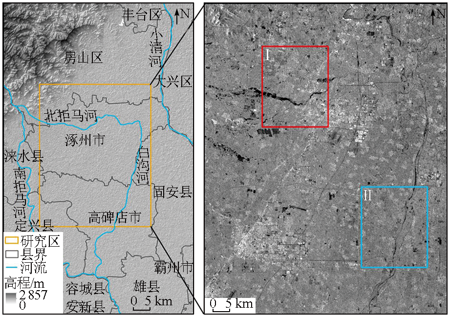
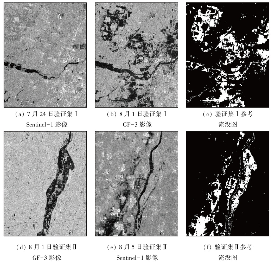
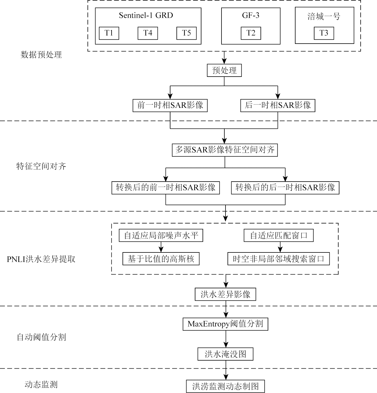
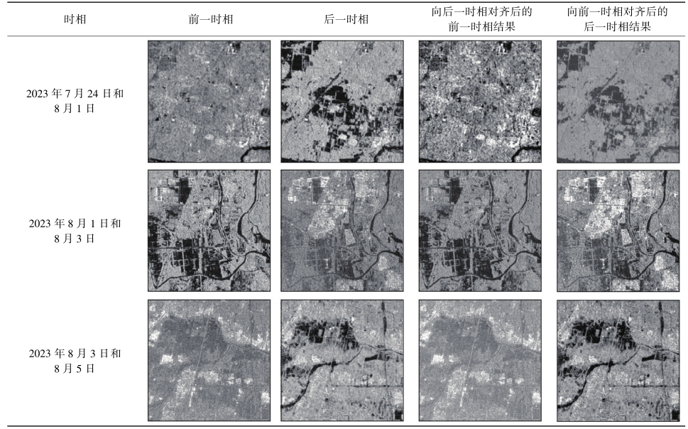
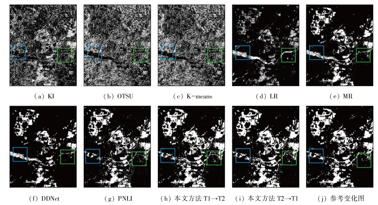
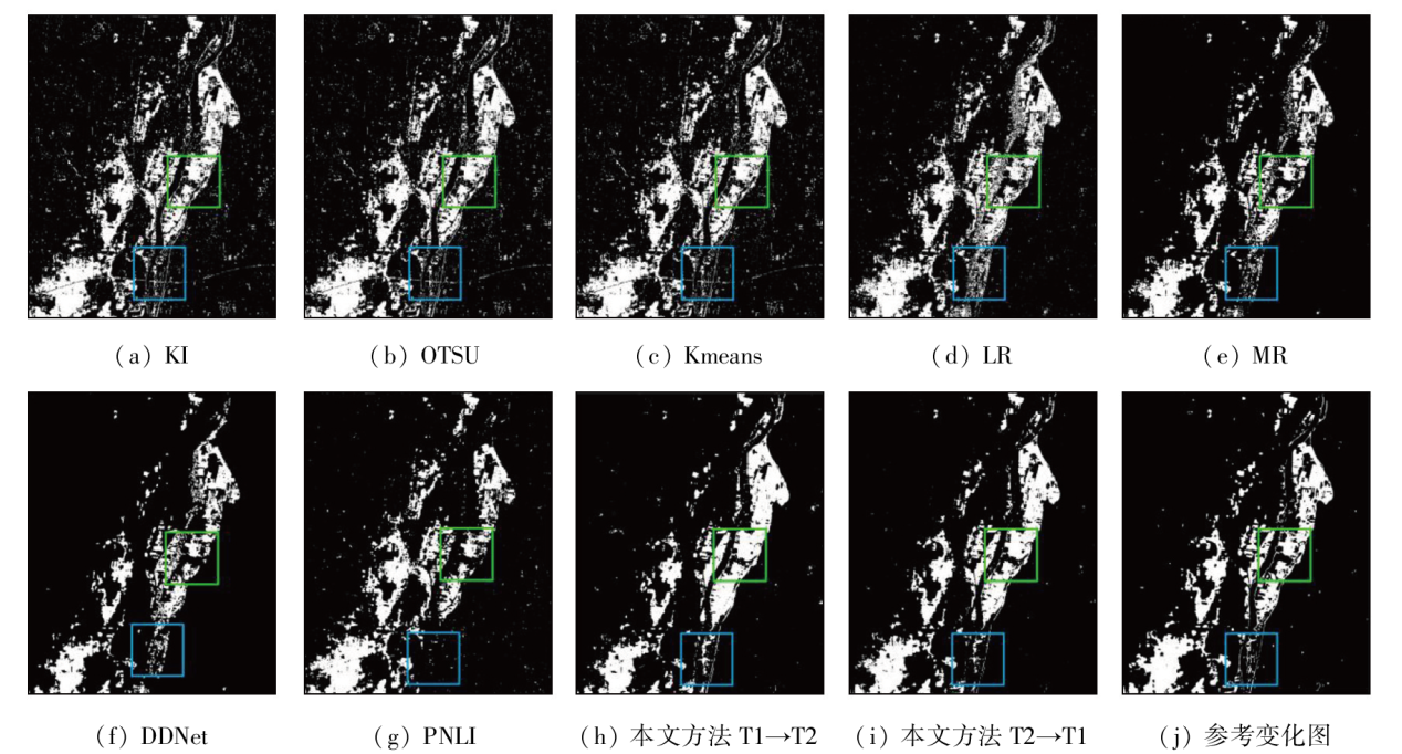
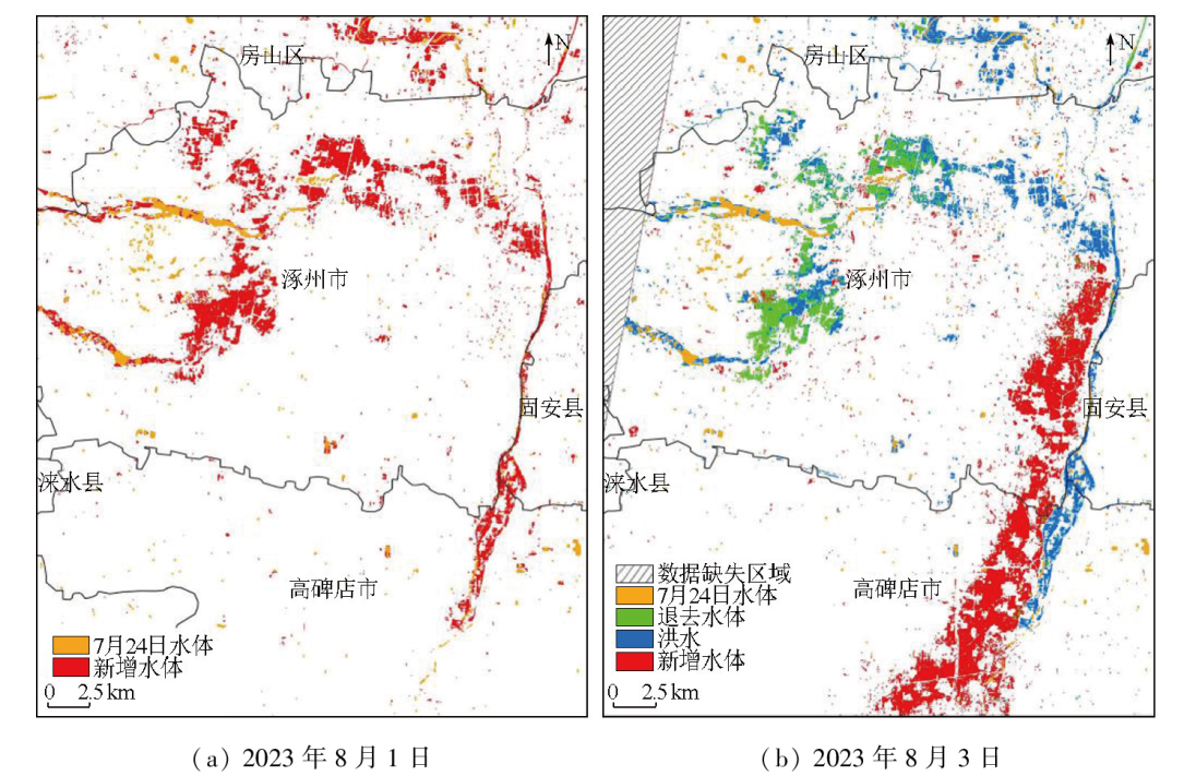
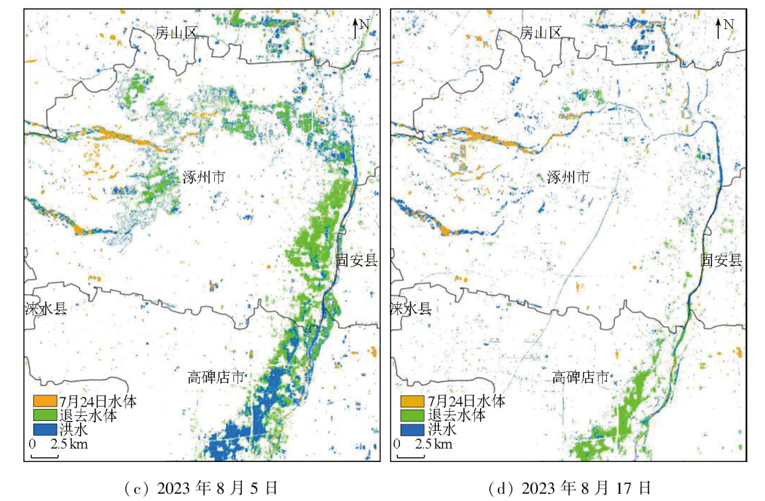
Abstract Synthetic aperture radar (SAR), allowing for all-weather and all-day imaging, can provide essential data for large-scale flood inundation monitoring. However, limitations such as the revisit period of SAR images make it challenging for single-source SAR data to meet the high temporal requirements for dynamic flood inundation monitoring, which is crucial for disaster relief and decision-making support. Combining multi-temporal SAR data for dynamic flood inundation monitoring is of significant practical value. Nevertheless, SAR images from different sensors exhibit significant spatiotemporal heterogeneity, rendering direct comparisons difficult. Additionally, previous studies frequently extracted flood inundation extents using single-pixel or local spatial neighborhood features while neglecting the application of spatiotemporal non-local features pre- and post-flooding. Therefore, this study first proposed a feature space alignment method for multi-source SAR data based on backscatter characteristics. Then, differential information pre- and post-flooding was extracted using the progressive non-local theory, and flood inundation maps were prepared. Finally, dynamic flood inundation monitoring results were obtained through logical operations of the time-series flood inundation maps. This method was validated using the flood disaster in August 2023 in Zhuozhou, during which five multi-source SAR datasets were acquired from Sentinel-1, Gaofen-3 (GF-3), and Fucheng-1. The results indicate that compared to six commonly used flood monitoring methods, the proposed method exhibited the optimal performance, yielding a Kappa coefficient and F1 score of 0.85 and 0.88, respectively. The dynamic monitoring results of the flood inundation in Zhuozhou reveal that the floodwater in the main urban area largely receded by August 3, and the water levels then gradually decreased, with the inundated areas shifting to the Baigou River in the lower reaches.
|
| Keywords
flood monitoring
synthetic aperture radar (SAR)
multi-source remote sensing
time-series monitoring
|
|
|
|
Issue Date: 23 December 2024
|
|
|
| [1] |
Hamidi E, Peter B G, Muñoz D F, et al. Fast flood extent monitoring with SAR change detection using google earth engine[J]. IEEE Transactions on Geoscience and Remote Sensing, 2023, 61:4201419.
|
| [2] |
李振洪, 王建伟, 胡羽丰, 等. 大范围洪涝灾害影响下的交通网受损快速评估[J]. 武汉大学学报(信息科学版), 2023, 48(7):1039-1049.
|
| [2] |
Li Z H, Wang J W, Hu Y F, et al. Rapid assessment of traffic inefficiency under flood scenarios over wide regions[J]. Geomatics and Information Science of Wuhan University, 2023, 48(7):1039-1049.
|
| [3] |
Blöschl G, Kiss A, Viglione A, et al. Current European flood-rich period exceptional compared with past 500 years[J]. Nature, 2020, 583(7817):560-566.
|
| [4] |
眭海刚, 赵博飞, 徐川, 等. 多模态序列遥感影像的洪涝灾害应急信息快速提取[J]. 武汉大学学报(信息科学版), 2021, 46(10):1441-1449.
|
| [4] |
Sui H G, Zhao B F, Xu C, et al. Rapid extraction of flood disaster emergency information with multi-modal sequence remote sensing images[J]. Geomatics and Information Science of Wuhan Univer-sity, 2021, 46(10):1441-1449.
|
| [5] |
李聪妤, 刘家奇, 刘欣鑫, 等. 适应复杂区域的时序SAR影像洪水监测与分析[J]. 遥感学报, 2024, 28(2):346-358.
|
| [5] |
Li C Y, Liu J Q, Liu X X, et al. Flood monitoring and analysis based on time-series SAR image for complex area[J]. National Remote Sensing Bulletin, 2024, 28(2):346-358.
|
| [6] |
阳驰轶, 官海翔, 吴玮, 等. 基于国产GF-3雷达影像的农田洪涝遥感监测方法[J]. 自然资源遥感, 2023, 35(4):71-80.doi:10.6046/zrzyyg.2023141.
|
| [6] |
Yang C Y, Guan H X, Wu W, et al. Remote sensing monitoring method for flooded farmland based on domestic GF-3 radar images[J]. Remote Sensing for Natural Resources, 2023, 35(4):71-80.doi:10.6046/zrzyyg.2023141.
|
| [7] |
何彬方, 姚筠, 冯妍, 等. 基于Sentinel-1A的安徽省2020年梅雨期洪水淹没监测[J]. 自然资源遥感, 2023, 35(1):140-147.doi:10.6046/zrzyyg.2022052.
|
| [7] |
He B F, Yao Y, Feng Y, et al. Sentinel-1A based flood inundation monitoring in Anhui Province during the plum rain period of 2020[J]. Remote Sensing for Natural Resources, 2023, 35(1):140-147.doi:10.6046/zrzyyg.2022052.
|
| [8] |
Shen X, Anagnostou E N, Allen G H, et al. Near-real-time non-obstructed flood inundation mapping using synthetic aperture radar[J]. Remote Sensing of Environment, 2019, 221:302-315.
|
| [9] |
郭山川, 杜培军, 蒙亚平, 等. 时序Sentinel-1A数据支持的长江中下游汛情动态监测[J]. 遥感学报, 2021, 25(10):2127-2141.
|
| [9] |
Guo S C, Du P J, Meng Y P, et al. Dynamic monitoring on flooding situation in the middle and lower reaches of the Yangtze River region using Sentinel-1A time series[J]. National Remote Sensing Bulletin, 2021, 25(10):2127-2141.
|
| [10] |
张文璇, 王卷乐. 基于SAR影像后向散射特性的中俄黑龙江流域洪水监测[J]. 地球信息科学学报, 2022, 24(4):802-813.
doi: 10.12082/dqxxkx.2022.210018
|
| [10] |
Zhang W X, Wang J L. Flood monitoring of Heilongjiang River Basin in China and Russia transboundary region based on SAR backscattering characteristics[J]. Journal of Geo-Information Science, 2022, 24(4):802-813.
|
| [11] |
黄平平, 段盈宏, 谭维贤, 等. 基于融合差异图的变化检测方法及其在洪灾中的应用[J]. 雷达学报, 2021, 10(1):143-158.
|
| [11] |
Huang P P, Duan Y H, Tan W X, et al. Change detection method based on fusion difference map in flood disaster[J]. Journal of Radars, 2021, 10(1):143-158.
|
| [12] |
Twele A, Cao W, Plank S, et al. Sentinel-1-based flood mapping:A fully automated processing chain[J]. International Journal of Remote Sensing, 2016, 37(13):2990-3004.
|
| [13] |
冷英, 李宁. 一种改进的变化检测方法及其在洪水监测中的应用[J]. 雷达学报, 2017, 6(2):204-212.
|
| [13] |
Leng Y, Li N. Improved change detection method for flood monitoring[J]. Journal of Radars, 2017, 6(2):204-212.
|
| [14] |
Dong Z, Liang Z, Wang G, et al. Mapping inundation extents in Poyang Lake area using Sentinel-1 data and transformer-based change detection method[J]. Journal of Hydrology, 2023, 620:129455.
|
| [15] |
Zhao B, Sui H, Liu J. Siam-DWENet:Flood inundation detection for SAR imagery using a cross-task transfer Siamese network[J]. International Journal of Applied Earth Observation and Geoinformation, 2023, 116:103132.
|
| [16] |
张庆君. 高分三号卫星总体设计与关键技术[J]. 测绘学报, 2017, 46(3):269-277.
doi: 10.11947/j.AGCS.2017.20170049
|
| [16] |
Zhang Q J. System design and key technologies of the GF-3 sate-llite[J]. Acta Geodaetica et Cartographica Sinica, 2017, 46(3):269-277.
|
| [17] |
Cao Y, Huang X. A full-level fused cross-task transfer learning method for building change detection using noise-robust pretrained networks on crowdsourced labels[J]. Remote Sensing of Environment, 2023, 284:113371.
|
| [18] |
Zhuang H, Fan H, Deng K, et al. Change detection in SAR images based on progressive nonlocal theory[J]. IEEE Transactions on Geo-science and Remote Sensing, 2022, 60:5229213.
|
| [19] |
Zhuang H, Hao M, Deng K, et al. Change detection in SAR images via ratio-based Gaussian kernel and nonlocal theory[J]. IEEE Transactions on Geoscience and Remote Sensing, 2022, 60:5210215.
|
| [20] |
Buades A, Coll B, Morel J M. A non-local algorithm for image denoising[C]// 2005 IEEE Computer Society Conference on Computer Vision and Pattern Recognition.IEEE, 2005:60-65.
|
| [21] |
Wong A K C, Sahoo P K. A gray-level threshold selection method based on maximum entropy principle[J]. IEEE Transactions on Systems,Man,and Cybernetics, 1989, 19(4):866-871.
|
| [22] |
Singh A. Review article digital change detection techniques using remotely-sensed data[J]. International Journal of Remote Sensing, 1989, 10(6):989-1003.
|
| [23] |
Ma J, Gong M, Zhou Z. Wavelet fusion on ratio images for change detection in SAR images[J]. IEEE Geoscience and Remote Sen-sing Letters, 2012, 9(6):1122-1126.
|
| [24] |
Qu X, Gao F, Dong J, et al. Change detection in synthetic aperture radar images using a dual-domain network[J]. IEEE Geoscience and Remote Sensing Letters, 2022, 19:4013405.
|
| [25] |
Kanungo T, Mount D M, Netanyahu N S, et al. An efficient k-means clustering algorithm:Analysis and implementation[J]. IEEE Transactions on Pattern Analysis and Machine Intelligence, 2002, 24(7):881-892.
|
| [26] |
Otsu N. A threshold selection method from gray-level histograms[J]. IEEE Transactions on Systems,Man,and Cybernetics, 1979, 9(1):62-66.
|
| [27] |
Kittler J, Illingworth J. Minimum error thresholding[J]. Pattern Recognition, 1986, 19(1):41-47.
|
| [28] |
Powers D M W. Evaluation:From precision,recall and F-measure to ROC,informedness,markedness and correlation[J/OL]. arXiv, 2020(2020-10-11). https://arxiv.org/abs/2010.16061.
url: https://arxiv.org/abs/2010.16061
|
|
Viewed |
|
|
|
Full text
|
|
|
|
|
Abstract
|
|
|
|
|
Cited |
|
|
|
|
| |
Shared |
|
|
|
|
| |
Discussed |
|
|
|
|
 2024,
Vol. 36
2024,
Vol. 36