|
|
 |
|

|
|
|
Distribution and rehabilitation status of lands destroyed by mining: A case study of Hebei Province |
YE Lijuan1,2( ), DUAN Xiaolong1,2, LI Ting1,2(), ZHANG Jing1,2, ZHANG Yun1,2, CHEN Donglei1,2 ), DUAN Xiaolong1,2, LI Ting1,2(), ZHANG Jing1,2, ZHANG Yun1,2, CHEN Donglei1,2 |
1. Tianjin Center, China Geological Survey(North China Center for Geoscience Innovation), Tianjin 300170, China
2. Tianjin Key Laboratory of Coast Geological Processes and Environmental Safety, Tianjin 300170, China |
|
|
|
|
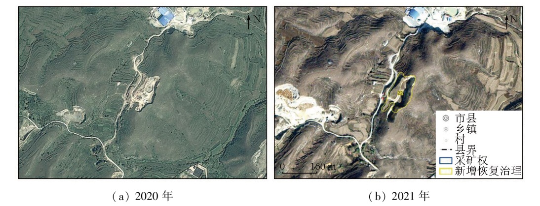
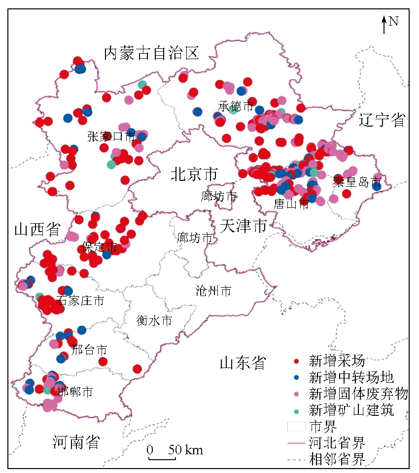
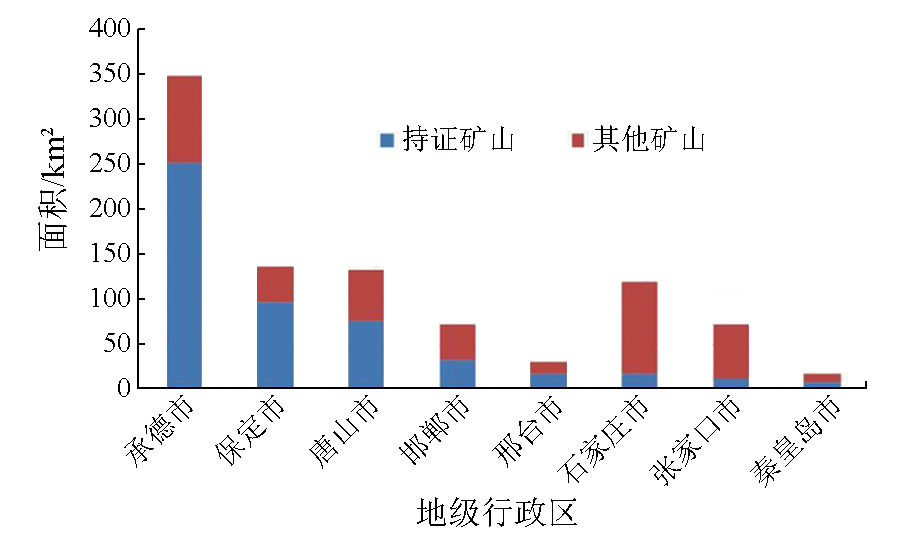
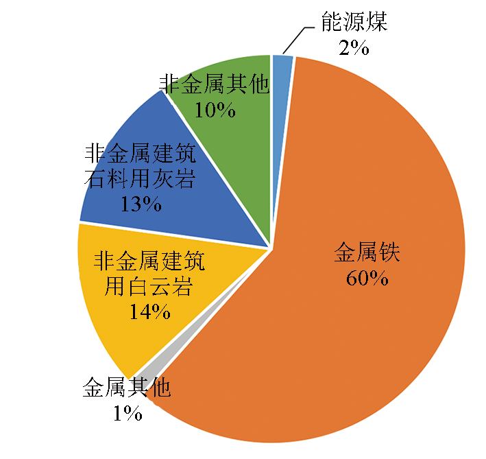
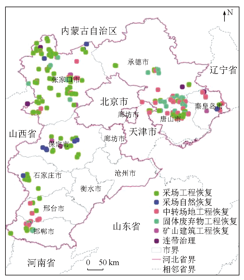
Abstract Remote sensing data with a high spatial resolution can be used to quickly ascertain the current status of the geological environment of mines in China, yielding objective and accurate results. By comparing 2020—2021 remote sensing images of 169 districts, counties, and cities in Hebei Province, 728 patches signaling suspected lands destroyed in mines were identified through interpretation. In 2021, the newly rehabilitated areas of the mining environment in Hebei Province reached 1 305.51 hm2, while the newly increased lands destroyed by mining were 932.13 hm2, resulting in a net increase of 373.38 hm2 in lands attributed to the geological environment rehabilitation. These results indicate the general achievement of mining while rehabilitating. Based on a preliminary analysis of the current status of the geological environment of mines in Hebei Province and existing primary issues, this study proposed countermeasures and recommendations for future rehabilitation efforts. The results of this study will provide foundational data and technical support for managing the geological environment of mines in Hebei Province and evaluating the effectiveness of mine greening initiatives.
|
| Keywords
remote sensing monitoring
land destroyed land
rehabilitation
Hebei Province
|
|
|
|
Issue Date: 23 December 2024
|
|
|
| [1] |
胡婷婷, 王亮, 邓久帅. 基于高质量发展的绿色矿山建设路径研究[J]. 现代矿业, 2022, 2 (2):246-254.
|
| [1] |
Hu T T, Wang L, Deng J S. Research on the path of green mines construction based on high-quality development[J]. Modern Mining, 2022, 2(2):246-254.
|
| [2] |
王庆民, 高翔. 河北省绿色矿山建设存在问题及对策研究[J]. 河北地质大学学报, 2022 (3):108-111.
|
| [2] |
Wang Q M, Gao X. Research on the problems and countermeasures of green mine construction in Hebei Province[J]. Journal of Hebei Geo University, 2022 (3):108-111.
|
| [3] |
高俊华, 邹联学, 龙欢, 等. 基于遥感动态监测的吉林省矿山地质环境及生态修复变化特征分析[J]. 自然资源遥感, 2022, 34(3):240-248.doi:10.6046/zrzyyg.2021278.
|
| [3] |
Gao J H, Zou L X, Long H, et al. Analysis on characteristics of mine geological environment and ecological restoration changes in Jilin Province based on dynamic remote sensing monitoring[J]. Remote Sensing for Natural Resources, 2022, 34(3):240-248.doi:10.6046/zrzyyg.2021278.
|
| [4] |
唐静秋. 浅析遥感信息技术在自然资源监测监管中的应用[J]. 测绘与空间地理信息, 2022, 45 (10):38-40.
|
| [4] |
Tang J Q. Exploration and application of remote sensing information technology in natural resources monitoring and supervision[J]. Geomatics and Spatial Information Technology, 2022, 45 (10):38-40.
|
| [5] |
祁帅, 乔文光, 张勇. 遥感技术在内蒙古绿色矿山地质环境动态监测中的应用[J]. 测绘通报, 2021 (1):79-82.
|
| [5] |
Qi S, Qiao W G, Zhang Y. Application of remote sensing in green mine environment monitoring in the Inner Mongolia Autonomous Region[J]. Bulletin of Surveying and Mapping, 2021 (1):79-82.
|
| [6] |
杨金中, 秦绪文, 聂洪峰, 等. 全国重点矿区矿山遥感监测综合研究[J]. 中国地质调查, 2015, 2(4):24-30.
|
| [6] |
Yang J Z, Qin X W, Nie H F, et al. Comprehensive research in remote sensing monitoring of the national concentration zones of the important mine[J]. Geological Survey of China, 2015, 2(4):24-30.
|
| [7] |
郑雄伟, 彭孛, 尚坤. 基于国产卫星的遥感地质解译能力评估[J]. 自然资源遥感, 2021, 33(3):1-10.doi:10.6046/zrzyyg.2020357.
|
| [7] |
Zheng X W, Peng B, Shang K. Assessment of the interpretation ability of domestic satellites in geological remote sensing[J]. Remote Sensing for Natural Resources, 2021, 33(3):1-10.doi:10.6046/zrzyyg.2020357.
|
| [8] |
杨金中, 许文佳, 姚维岭, 等. 全国采矿损毁土地分布与治理状况及存在问题[J]. 地学前缘, 2021, 28(4):83-89.
doi: 10.13745/j.esf.sf.2020.10.8
|
| [8] |
Yang J Z, Xu J W, Yao W L, et al. Land destroyed by mining in China: Damage distribution,rehabilitation status and existing problems[J]. Earth Science Frontiers, 2021, 28(4):83-89.
|
| [9] |
于博文, 田淑芳, 赵永超, 等. 高分一号卫星在京津矿山遥感监测中的应用[J]. 现代地质, 2017, 31(4):843-850.
|
| [9] |
Yu B W, Tian S F, Zhao Y C, et al. Application of GF-1 satellite in remote sensing monitoring on mine exploitation in Beijing and Tianjin[J]. Geoscience, 2017, 31(4):843-850.
|
| [10] |
孔卓, 杨海涛, 郑逢杰, 等. 高光谱遥感图像大气校正研究进展[J]. 自然资源遥感, 2022, 34(4):1-10.doi:10.6046/zrzyyg.2021371.
|
| [10] |
Kong Z, Yang H T, Zheng F J, et al. Research advances in atmospheric correction of hyperspectral remote sensing images[J]. Remote Sensing for Natural Resources, 2022, 34(4):1-10.doi:10.6046/zrzyyg.2021371.
|
| [11] |
刘欢, 张云, 黄旭红, 等. 遥感技术在内蒙古自治区中西部重点矿区开采监测中的应用[J]. 华北地质, 2021, 44(4):55-60.
|
| [11] |
Liu H, Zhang Y, Huang X H, et al. Application of remote sensing technology in mining monitoring in midwest major mining area of Inner Mongolia[J]. North China Geology, 2021, 44(4):55-60.
|
| [12] |
张仙, 李伟, 陈理, 等. 露天开采矿区要素遥感提取研究进展及展望[J]. 自然资源遥感, 2023, 35(2):25-33.doi:10.6046/zrzyyg.2022141.
|
| [12] |
Zhang X, Li W, Chen L, et al. Research progress and prospect of remote sensing-based feature extraction of opencast mining areas[J]. Remote Sensing for Natural Resources, 2023, 35(2):25-33.doi:10.6046/zrzyyg.2022141.
|
| [13] |
金玉玲, 黄礼霞, 李香莉. 遥感解译在露天矿山生产监测中的应用[J]. 测绘与空间地理信息, 2022, 45(12):91-94.
|
| [13] |
Jin Y L, Huang L X, Li X L. Application of remote sensing interpretation in production monitoring of mines[J]. Geomatics and Spatial Information Technology, 2022, 45(12):91-94.
|
| [14] |
李俊建, 彭翼, 张彤, 等. 华北地区成矿单元划分[J]. 华北地质, 2021, 44(3):4-24.
|
| [14] |
Li J J, Peng Y, Zhang T, et al. Division of metallogenic units in North China[J]. North China Geology, 2021, 44(3):4-24.
|
| [15] |
杨金中, 聂洪峰, 荆青青. 初论全国矿山地质环境现状与存在问题[J]. 国土资源遥感, 2017, 29(2):1-7.doi:10.6046/gtzyyg.2017.02.01.
|
| [15] |
Yang J Z, Nie H F, Jing Q Q. Preliminary analysis of mine geo-environment status and existing problems in China[J]. Remote Sensing for Land and Resources, 2017, 29(2):1-7.doi:10.6046/gtzyyg.2017.02.01.
|
| [16] |
黄登冕, 张聪, 姚晓军, 等. 矿山环境遥感监测研究进展[J]. 遥感技术与应用, 2022, 37(5):1043-1055.
doi: 10.11873/j.issn.1004-0323.2022.5.1043
|
| [16] |
Huang D M, Zhang C, Yao X J, et al. Research Progress of Mine Environment Remote Sensing Monitoring[J]. Remote Sensing Technology and Application, 2022, 37(5):1043-1055.
|
| [17] |
王建华, 李阳, 梁树能, 等. 基于高光谱卫星数据的土地沙化识别及提取研究[J]. 华北地质, 2022, 45(4):61-67
|
| [17] |
Wang J H, Li Y, Liang S N, et al. The study of land desertification recognition and extraction based on hyperspectral satellite data[J]. North China Geology, 2022, 45(4):61-67.
|
| [18] |
王润生, 熊盛青, 聂洪峰, 等. 遥感地质勘查技术与应用研究[J]. 地质学报, 2011, 85(11):1699-1743.
|
| [18] |
Wang R S, Xiong S Q, Nie H F, et al. Remote Sensing Technology and its Application in Geological Exploration[J]. Acta Geologica Sinica, 2011, 85(11):1699-1743.
|
| [19] |
何芳, 刘瑞平, 徐友宁, 等. 基于遥感的木里煤矿区矿山地质环境监测及评价[J]. 地质通报, 2018. 37(12):2251-2259.
|
| [19] |
He F, Liu R P, Xu Y N, et al. Monitoring and evaluation of mine geological environment in the Muli coal mining area based on remote sensing[J]. Geological Bulletin of China, 2018, 37(12):2251-2259.
|
|
Viewed |
|
|
|
Full text
|
|
|
|
|
Abstract
|
|
|
|
|
Cited |
|
|
|
|
| |
Shared |
|
|
|
|
| |
Discussed |
|
|
|
|
 2024,
Vol. 36
2024,
Vol. 36