|
|
 |
|

|
|
|
Exploring the spatial distribution of surface deformations along the China-Laos railway based on SBAS-InSAR technology: Taking the Jinghong section as an example |
JIN Tingting1( ), XI Wenfei1,2(), QIAN Tanghui1, GUO Junqi1, HONG Wenyu1, DING Zitian1, GUI Fuyu1 ), XI Wenfei1,2(), QIAN Tanghui1, GUO Junqi1, HONG Wenyu1, DING Zitian1, GUI Fuyu1 |
1. Department of Geography, Yunnan Normal University,Kunming 650500,China
2. The Key Laboratory of Plateau Geographic Process and Environmental Change in Yunnan Province,Kunming 650500,China |
|
|
|
|
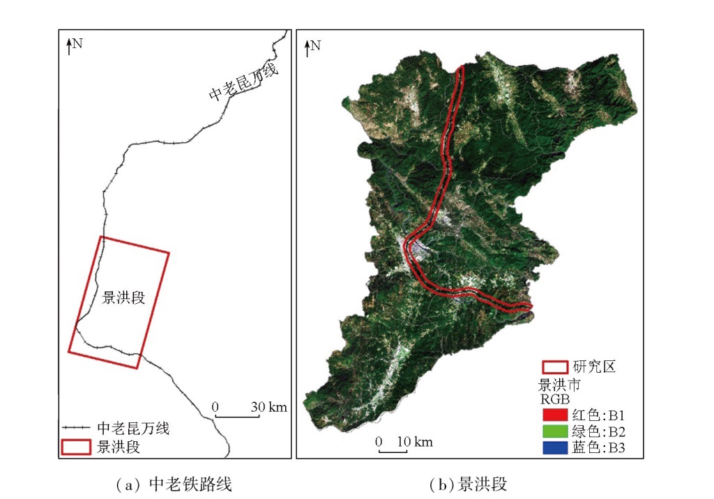
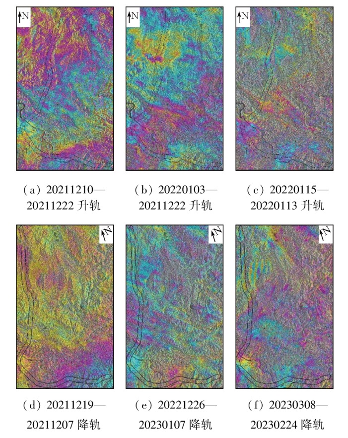
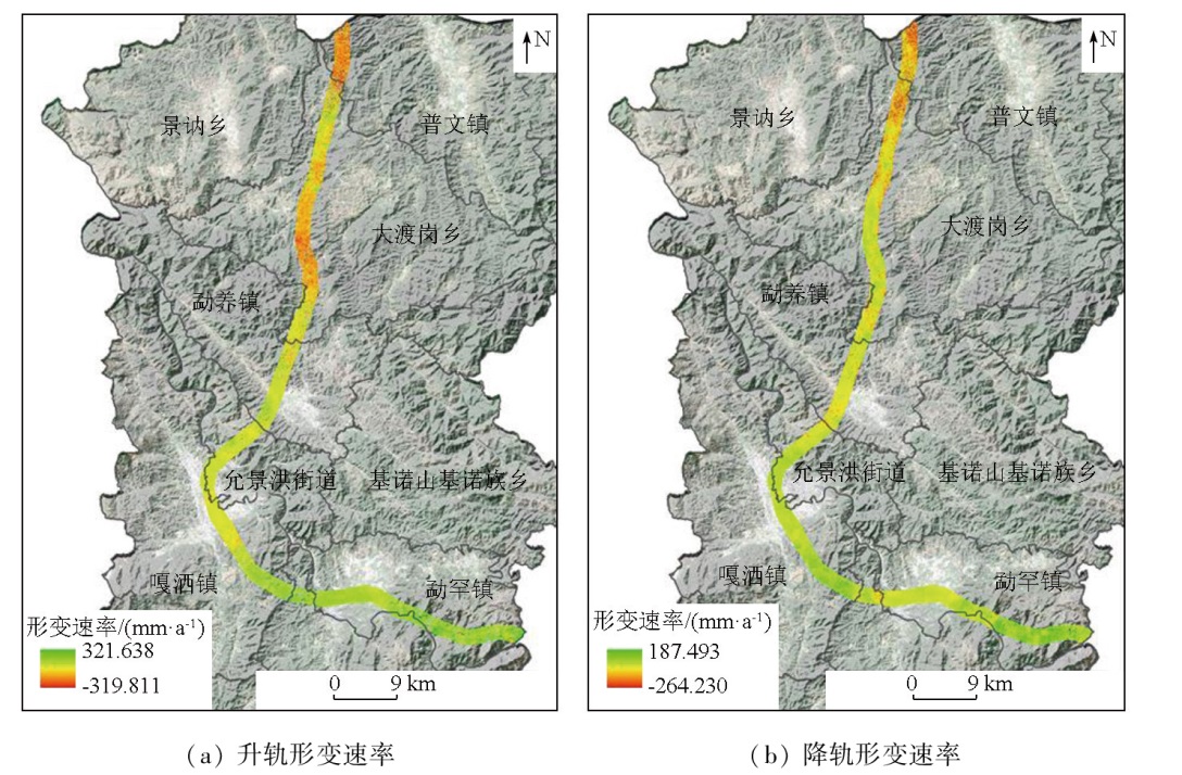
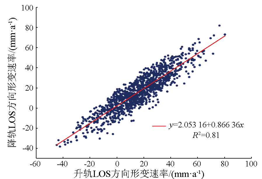
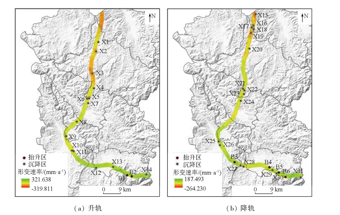
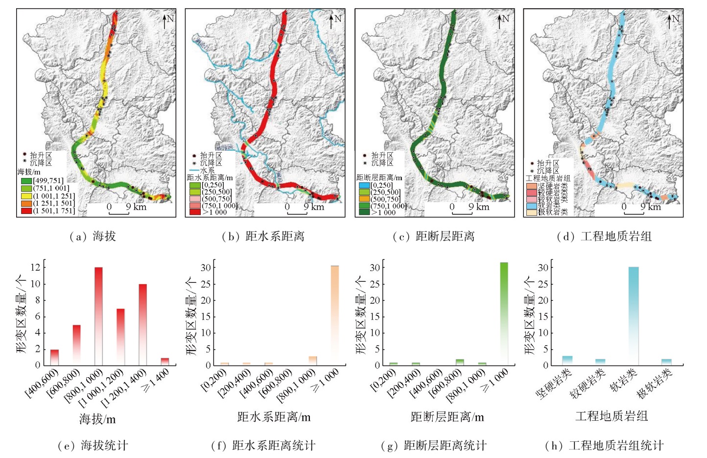
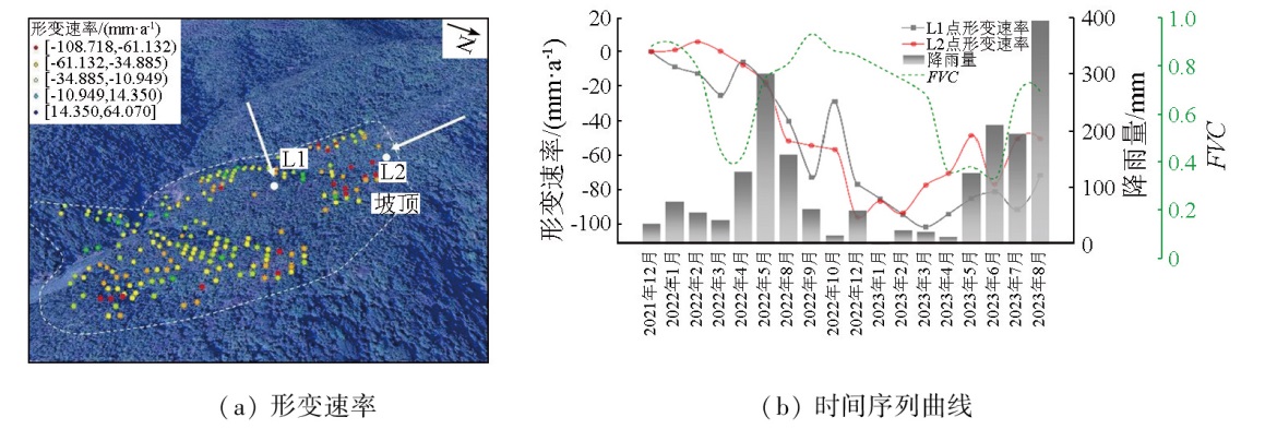
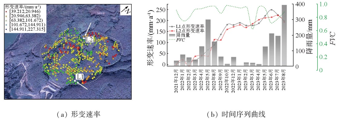
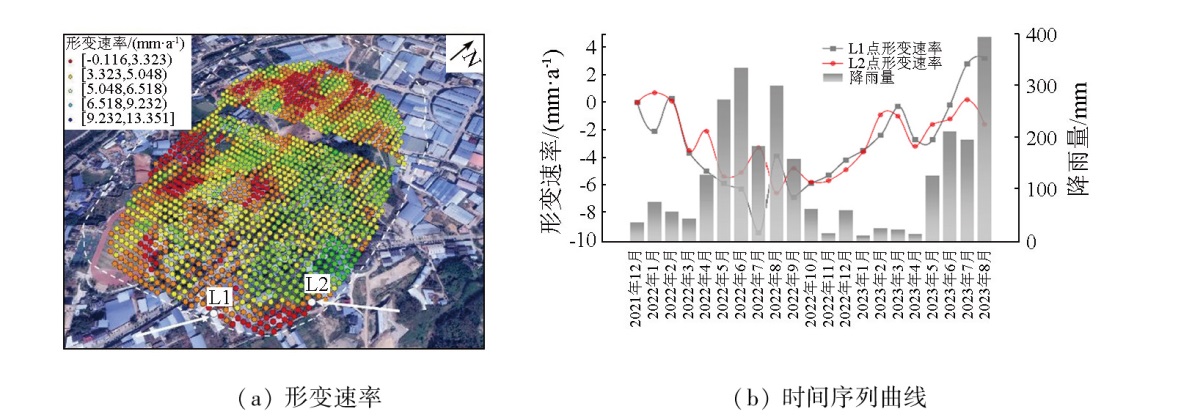
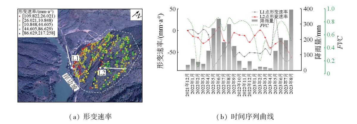
Abstract Surface deformations pose significant threats to the normal operation of railways. Investigating the spatial distribution of surface deformations along the China-Laos railway holds great significance for disaster prevention and mitigation. Based on 36 scenes of ascending orbit and 50 scenes of descending orbit images from Sentinel-1A satellite from December 2021 to August 2023, this study conducted deformation inversion using the small baseline subset interferometric synthetic aperture Radar (SBAS-InSAR) technique. Besides, this study conducted spatial distribution statistics and analysis of surface deformations along the Jinghong section of the China-Laos railway. The results indicate that the overall deformation along the railway exhibits a heterogeneous distribution, with multiple potential hazards in the northern mountainous area. Among the selected typical deformation zones, the maximum subsidence rate in the northern mountainous area reaches -108.718 mm/a, whereas the southern plain area shows significant uplift with a rate of 227.315 mm/a. Along the railway, the surface deformation rates in the line of sight (LOS) direction ranged from -319.811 mm/a to 321.638 mm/a. Obvious subsidence occurred in Puwen Town and Dadugang Township. Conversely, minor subsidence was observed in urban areas like Mengyang town, Yunjinghong subdistrict, and Gasa town, with pronounced uplifts in the southeastern part of Menghan town. Along the railway, deformations in mountainous areas were primarily concentrated at elevations ranging from 800 m to 1400 m, with soft rocks prevailing in these deformed areas. InSAR-based analysis of the spatial distribution of the surface deformations along the railway is of significant value for the safe operation of the railway.
|
| Keywords
small baseline subset interferometric synthetic aperture Radar (SBAS-InSAR)
surface deformation
China-Laos railway
spatial distribution
|
|
|
|
Issue Date: 03 September 2025
|
|
|
| [1] |
刘凯斯, 宫辉力, 陈蓓蓓. 基于InSAR数据的北京地铁6号线地面沉降监测分析[J]. 地球信息科学学报, 2018, 20(1):128-137.
doi: 10.12082/dqxxkx. 2018.170287
|
| [1] |
Liu K S, Gong H L, Chen B B. Monitoring and analysis of land subsidence of Beijing Metro Line 6 based on InSAR data[J]. Journal of Geo-Information Science, 2018, 20(1):128-137.
|
| [2] |
罗三明, 杜凯夫, 万文妮, 等. 利用PSInSAR方法反演大时空尺度地表沉降速率[J]. 武汉大学学报(信息科学版), 2014, 39(9):1128-1134.
|
| [2] |
Luo S M, Du K F, Wan W N, et al. Ground subsidence rate inversion of large temporal and spatial scales based on extended PSInSAR method[J]. Geomatics and Information Science of Wuhan University, 2014, 39(9):1128-1134.
|
| [3] |
赵国堂, 赵如锋, 刘俊飞. 高速铁路路基工后沉降变形源、变形传递与轨道不平顺控制方法[J]. 铁道学报, 2020, 42(12):127-134.
|
| [3] |
Zhao G T, Zhao R F, Liu J F. Deformation source,deformation transmission of post-construction settlement and control methods of track irregularity for high-speed railway subgrade[J]. Journal of the China Railway Society, 2020, 42(12):127-134.
|
| [4] |
刘春雷, 张媛静, 陆晨明, 等. 基于时序InSAR的九龙江河口地区地面沉降时空演变规律及成因分析[J]. 应用海洋学学报, 2024, 43(1):116-125.
|
| [4] |
Liu C L, Zhang Y J, Lu C M, et al. Spatial-temporal variation characteristics and causes analysis of ground deformation in Jiulong River Estuary area by time series InSAR[J]. Journal of Applied Oceanography, 2024, 43(1):116-125.
|
| [5] |
范军, 左小清, 李涛, 等. PS-InSAR和SBAS-InSAR技术对昆明主城区地面沉降监测的对比分析[J]. 测绘工程, 2018, 27(6):50-58.
|
| [5] |
Fan J, Zuo X Q, Li T, et al. Analysis and comparison of PS-InSAR and SBAS-InSAR for ground subsidence monitoring in the main city of Kunming[J]. Engineering of Surveying and Mapping, 2018, 27(6):50-58.
|
| [6] |
朱军桃, 兰荣添, 李海林, 等. 基于时序InSAR的厦门市地面沉降监测与分析[J]. 海洋测绘, 2023, 43(5):56-60,66.
|
| [6] |
Zhu J T, Lan R T, Li H L, et al. Monitoring and analysis of land subsidence in Xiamen City based on time-series InSAR[J]. Hydrographic Surveying and Charting, 2023, 43(5):56-60,66.
|
| [7] |
曹景峰, 刘洪铖. 基于Quickbird影像的水库库岸滑坡遥感解译研究[J]. 吉林水利, 2017(12):4-6,10.
|
| [7] |
Cao J F, Liu H C. Study on interpretation of the reservoir landslide based on QuickBird remote sensing images[J]. Jilin Water Resources, 2017(12):4-6,10.
|
| [8] |
朱怡飞, 姚鑫, 姚磊华, 等. 基于InSAR和光学遥感的贵州鬃岭采煤滑坡识别与危险性评价[J]. 地质力学学报, 2022, 28(2):268-280.
|
| [8] |
Zhu Y F, Yao X, Yao L H, et al. Identification and risk assessment of coal mining-induced landslides in Guizhou Province by InSAR and optical remote sensing[J]. Journal of Geomechanics, 2022, 28(2):268-280.
|
| [9] |
卫达宁, 王世杰. 基于时序InSAR技术的西安地铁沿线沉降监测及预测分析[J]. 地球物理学进展, 2024, 39(2):498-509.
|
| [9] |
Wei D N, Wang S J. Settlement monitoring and analysis along Xi’an metro line based on time series InSAR technology[J]. Progress in Geophysics, 2024, 39(2):498-509.
|
| [10] |
王艳, 廖明生, 李德仁, 等. 利用长时间序列相干目标获取地面沉降场[J]. 地球物理学报, 2007, 50(2):598-604.
|
| [10] |
Wang Y, Liao M S, Li D R, et al. Subsidence velocity retrieval from long-term coherent targets in Radar interferometric stacks[J]. Chinese Journal of Geophysics, 2007, 50(2):598-604.
|
| [11] |
葛鹏飞, 刘辉, 陈蜜, 等. 时序InSAR监测京雄城际铁路河北段地面沉降[J]. 测绘通报, 2022(7):64-70.
doi: 10.13474/j.cnki.11-2246.2022.0205
|
| [11] |
Ge P F, Liu H, Chen M, et al. Monitoring land subsidence of Hebei section of Beijing-Xiongan intercity railway by time-series InSAR[J]. Bulletin of Surveying and Mapping, 2022(7):64-70.
|
| [12] |
陈宝山, 张立峰, 何毅, 等. 兰新高速铁路军马场-民乐段地表形变监测及成因[J]. 兰州大学学报(自然科学版), 2022, 58(2):222-228,238.
|
| [12] |
Chen B S, Zhang L F, He Y, et al. Surface deformation monitoring and cause analysis of the section from the army horse ranch to Minle station of the Lanxin high-speed railway[J]. Journal of Lanzhou University (Natural Sciences), 2022, 58(2):222-228,238.
|
| [13] |
Heleno S I N, Oliveira L G S, Henriques M J, et al. Persistent Scatterers Interferometry detects and measures ground subsidence in Lisbon[J]. Remote Sensing of Environment, 2011, 115(8):2152-2167.
|
| [14] |
张学东, 葛大庆, 肖斌, 等. 多轨道集成PS-InSAR监测高速公路沿线地面沉降研究——以京沪高速公路(北京—河北)为例[J]. 测绘通报, 2014(10):67-69,104.
|
| [14] |
Zhang X D, Ge D Q, Xiao B, et al. Study on multi-track integration PS-InSAR monitoring the land subsidence along the highway—Taking Jinghu highway(Beijing-Hebei) as an example[J]. Bulletin of Surveying and Mapping, 2014(10):67-69,104.
|
| [15] |
He Y, Chen Y, Wang W, et al. TS-InSAR analysis for monitoring ground deformation in Lanzhou New District,the loess Plateau of China,from 2017 to 2019[J]. Advances in Space Research, 2021, 67(4):1267-1283.
|
| [16] |
Wang W, He Y, Zhang L, et al. Analysis of surface deformation and driving forces in Lanzhou[J]. Open Geosciences, 2020, 12(1):1127-1145.
|
| [17] |
陈有东, 何毅, 张立峰, 等. 联合升降轨Sentinel-1A的地表形变监测技术研究[J]. 海洋测绘, 2020, 40(4):59-64.
|
| [17] |
Chen Y D, He Y, Zhang L F, et al. Research on ground deformation monitoring technique of jointing ascending and descending Sentinel-1A[J]. Hydrographic Surveying and Charting, 2020, 40(4):59-64.
|
| [18] |
王文辉, 何毅, 张立峰, 等. 基于PS-InSAR和GeoDetector的兰州主城区地表变形监测与驱动力分析[J]. 兰州大学学报(自然科学版), 2021, 57(3):382-388,394.
|
| [18] |
Wang W H, He Y, Zhang L F, et al. Ground deformation monitoring and driving force analysis of the main city area in Lanzhou based on PS-InSAR and GeoDetector[J]. Journal of Lanzhou University (Natural Sciences), 2021, 57(3):382-388,394.
|
| [19] |
张诗茄, 蒋建军, 缪亚敏, 等. 基于SBAS技术的岷江流域潜在滑坡识别[J]. 山地学报, 2018, 36(1):91-97.
|
| [19] |
Zhang S J, Jiang J J, Miao Y M, et al. Application of the SBAS technique in potential landslide identification in the Minjiang watershed[J]. Mountain Research, 2018, 36(1):91-97.
|
| [20] |
李凌婧, 姚鑫, 张永双, 等. 基于SBAS-InSAR技术的中巴公路(公格尔—墓士塔格段)地质体缓慢变形识别研究[J]. 工程地质学报, 2014, 22(5):921-927.
|
| [20] |
Li L J, Yao X, Zhang Y S, et al. SBAS-InSAR technology based identification of slow deformation of geologic mass along section of China-Pakistan highway[J]. Journal of Engineering Geology, 2014, 22(5):921-927.
|
| [21] |
Berardino P, Fornaro G, Lanari R, et al. A new algorithm for surface deformation monitoring based on small baseline differential SAR interferograms[J]. IEEE Transactions on Geoscience and Remote Sensing, 2002, 40(11):2375-2383.
|
| [22] |
何清, 魏路, 肖永红. 基于SBAS-InSAR技术的安徽亳州市地面沉降时空分布特征与影响因素分析[J]. 中国地质灾害与防治学报, 2023, 34(5):81-90.
|
| [22] |
He Q, Wei L, Xiao Y H. Analysis of spatial-temporal distribution characteristics and influencing factors of land subsidence in Bozhou City,Anhui Province based on SBAS-InSAR technology[J]. The Chinese Journal of Geological Hazard and Control, 2023, 34(5):81-90.
|
| [23] |
Su X J, Zhang Y, Meng X M, et al. Landslide mapping and analysis along the China-Pakistan Karakoram Highway based on SBAS-InSAR detection in 2017[J]. Journal of Mountain Science, 2021, 18(10):2540-2564.
|
|
Viewed |
|
|
|
Full text
|
|
|
|
|
Abstract
|
|
|
|
|
Cited |
|
|
|
|
| |
Shared |
|
|
|
|
| |
Discussed |
|
|
|
|
 2025,
Vol. 37
2025,
Vol. 37