|
|
 |
|

|
|
|
Application of remote sensing technology to hydrogeological environment survey in the Luoji mountain area, western Sichuan Province |
| Fuqiang CHEN1, Guoshi DENG2, Xingyi JI1, Yunfeng ZHANG1, Chaowei JIAO1, Chun FENG1 |
1. Xi’an Northwest Geological Institude of Nonferrous Metals Ltd, Xi’an 710054, China
2. Chengdu Center of China Geological Survey, Chengdu 610081, China |
|
|
|
|
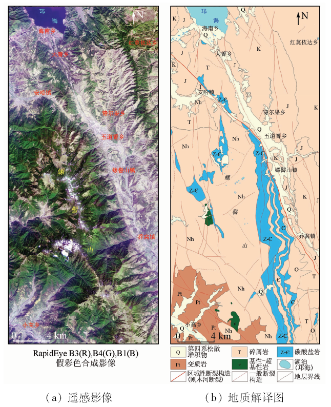
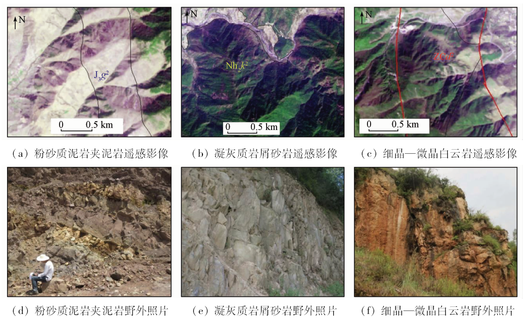
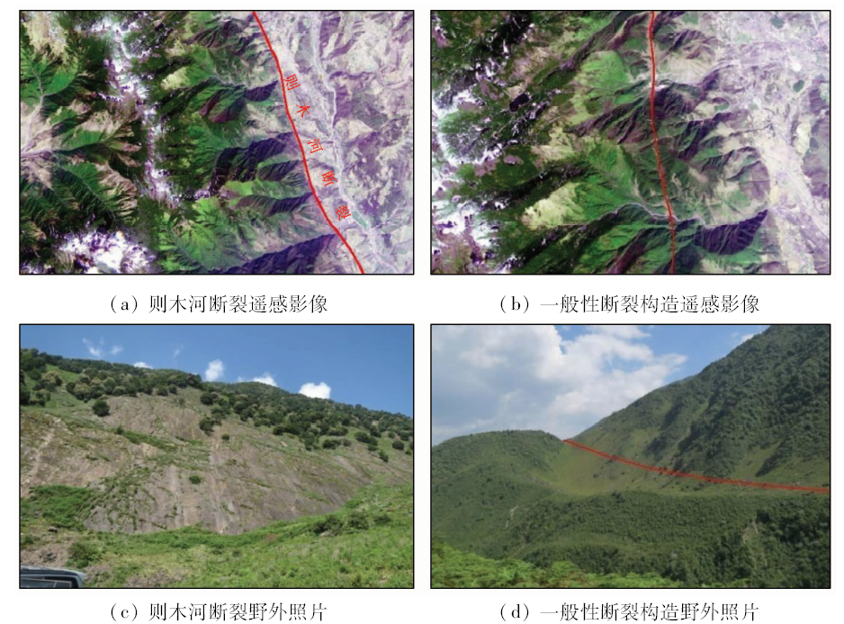
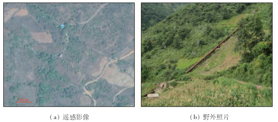
Abstract Based on an analysis of geological structure and environmental geological conditions in the Luojishan area, western Sichuan, the authors comprehensively interpreted and analyzed the basic geological elements such as formation and structure, hydrogeological elements such as surface water and groundwater, geological hazards, vegetation, cultivated land, residential land, surface temperature and other environmental geological factors by using RapidEye data, Landsat8 OLI data and network high-definition data images. Combined with the field survey data, the authors evaluated the hydrogeological environment of the study area and, based on remote sensing information, graded the water richness of water-bearing rocks, and divided them into abundant water resource area, medium water resource area and poor water resource area, which provides basic remote sensing data for carrying out further hydrogeological survey work in this area.
|
| Keywords
remote sensing
Luoji Mountain
geological interpretation
hydrogeology
environmental geology
|
|
|
|
Issue Date: 03 December 2019
|
|
|
| [1] |
熊盛青 . 国土资源遥感技术进展与展望[J]. 国土资源遥感, 2007,19(4):1-6.doi: 10.6046/gtzyyg.2007.04.01.
doi: 10.6046/gtzyyg.2007.04.01
|
| [1] |
Xiong S Q . The progress and development trend of the application of remote sensing to land and resources[J]. Remote Sensing for Land and Resources, 2007,19(4):1-6.doi: 10.6046/gtzyyg.2007.04.01.
|
| [2] |
徐冠华, 柳钦火, 陈良富 , 等. 遥感与中国可持续发展:机遇和挑战[J]. 遥感学报, 2016,20(05):679-688.
|
| [2] |
Xu G H, Liu Q H, Chen L F , et al. Remote sensing for China’s sustainable development:Opportunities and challenges[J]. Journal of Remote Sensing, 2016,20(5):679-688.
|
| [3] |
王润生, 熊盛青, 聂洪峰 , 等. 遥感地质勘查技术与应用研究[J]. 地质学报, 2011,85(11):1699-1743.
|
| [3] |
Wang R S, Xiong S Q, Nie H F , et al. Remote sensing technology and its application in geological exploration[J]. Acta Geologica Sinica. 2011,85(11):1699-1743.
|
| [4] |
顾行发, 余涛, 田国良 , 等. 40年的跨越-中国航天遥感蓬勃发展中的“三大战役”[J]. 遥感学报, 2016,20(5):781-793.
|
| [4] |
Gu X F, Yu T, Tian G L , et al. Up to the higher altitude—the new “three campaigns” for the development of China spaceborne remote sensing application[J]. Journal of Remote Sensing, 2016,20(5):781-793.
|
| [5] |
刘德长, 李志忠, 王俊虎 . 我国遥感地质找矿的科技进步与发展前景[J]. 地球信息科学学报, 2011,13(04):431-438.
|
| [5] |
Liu D C, Li Z Z, Wang J H . The technology progress and developing future of remote sensing geological prospecting in China[J]. Journal of Geo-information Science, 2011,13(04):431-438.
|
| [6] |
陈富强, 薛杉, 冯源 , 等. 莽西地区遥感成矿预测[J]. 遥感信息, 2016,31(1):102-105.
|
| [6] |
Chen F Q, Xue S, Feng Y , et al. Application of remote sensing on metallogenic prognosis in west Mangling Pluton[J]. Remote Sensing Information, 2016,31(1):102-105.
|
| [7] |
汪冰, 张大明, 魏本赞 , 等. 高分辩率遥感在青海卡尔却卡地区铜多金属矿找矿预测中的应用[J]. 地质找矿论丛, 2017,32(1):107-113.
|
| [7] |
Wang B, Zhang D M, Wei B Z , et al. The application of high resolution remote sensing image to ore prediction in Skarn copper polymetallic deposit,Kaerqueka area,Qinhai[J]. Contributions to Geology and Mineral Resources Research, 2017,32(1):107-113.
|
| [8] |
陈富强, 焦超卫, 张云峰 , 等. 青海省芒崖镇大通沟南山地区遥感地质特征及找矿预测[J]. 地质找矿论丛, 2017,32(4):612-618.
|
| [8] |
Chen F Q, Jiao C W, Zhang Y F , et al. Remote sensing geological characteristics and prospecting prediction in Nan mountain of Da Tong ditch,Mangai Area,Qinghai[J]. Contributions to Geology and Mineral Resources Research, 2017,32(4):612-618.
|
| [9] |
范一大, 吴玮, 王薇 , 等. 中国灾害遥感研究进展[J]. 遥感学报, 2016,20(5):1170-1184.
|
| [9] |
Fan Y D, Wu W, Wang W , et al. Research progress of disaster remote sensing in China[J]. Journal of Remote Sensing, 2016,20(5):1170-1184.
|
| [10] |
戴晓爱 . 生态水信息指标参数遥感反演模型研究[D]. 成都:成都理工大学, 2012.
|
| [10] |
Dai X A . Study on Remote Sensing Retriveral Models about Ecological Water Information Index[D]. Chengdu:Chengdu University of Technology, 2012.
|
| [11] |
李晓民, 燕云鹏, 刘刚 , 等. ZY-102C星数据在西藏札达地区水文地质调查中的应用[J]. 国土资源遥感, 2016,28(4):141-148.doi: 10.6046/gtzyyg.2016.04.22.
doi: 10.6046/gtzyyg.2016.04.22
|
| [11] |
Li X M, Yan Y P, Liu G , et al. Application of ZY-102C satellite data to hydrogeological investigation in Zanda area,Tibet[J]. Remote Sensing for Land and Resources, 2016,28(4):141-148.doi: 10.6046/gtzyyg.2016.04.22.
|
| [12] |
邓正栋, 叶欣, 龙凡 , 等. 地下水遥感模糊评估指数的构建与研究[J]. 地球物理学报, 2013,56(11):3908-3916.
doi: 10.6038/cjg20131132
|
| [12] |
Deng Z D, Ye X, Long F , et al. Construction and investigation of groundwater remote sensing fuzzy assessment index[J]. Chinese Journal of Geophysics, 2013,56(11):3908-3916.
|
| [13] |
杨清华, 陈华, 路云阁 , 等. 全国边海防地区基础地质遥感调查[J]. 中国地质调查, 2017,4(3):1-9.
|
| [13] |
Yang Q H, Chen H, Lu Y G , et al. Basic geological remote sensing survey in national terrestrial and marine border region[J]. Geological Survey of China, 2017,4(3):1-9.
|
| [14] |
安国英 . 遥感技术在新生代水文地质调查中的应用:以喀喇昆仑山温泉幅1:25万区域水文地质调查为例[J]. 现代地质, 2013,27(6):1445-1453.
|
| [14] |
An G Y . Application of satellite remote sensing in regional hydrogeological investigation:Taking Cenozoic Strata in Wenquan sheet (1:250,000) of Karakoram range as an example[J]. Geoscience, 2013,27(6):1445-1453.
|
| [15] |
齐蕊, 王旭升, 万力 , 等. 地下水和干旱指数对植被指数空间分布的联合影响:以鄂尔多斯高原为例[J]. 地学前缘, 2017,24(2):265-273.
|
| [15] |
Qi R, Wang X S, Wan L , et al. Joint influences of groundwater and aridity index on the spatial distribution of vegetation index:A case study in the Ordos Plateau,China[J]. Earth Science Frontiers, 2017,24(2):265-273.
|
| [16] |
程洋, 吕勇, 涂杰楠 , 等. 遥感技术在岩溶区1:50000区域地质调查中的应用——以黔西北地区为例[J]. 地质力学学报, 2016,22(4):921-932.
|
| [16] |
Cheng Y, Lv Y, Tu J N , et al. Application of remote sensing technology in the 1:50000 regional geological survey in karst area:A case study of northwest Guizhou[J]. Journal of Geomechanics, 2016,22(4):921-932.
|
| [17] |
袁沫汐, 邹玲, 林爱文 , 等. 湖北省地区植被覆盖变化及其对气候因子的响应[J]. 生态学报, 2016,36(17):5315-5323.
doi: 10.5846/stxb201507101464
|
| [17] |
Yuan M X, Zou L, Lin A W , et al. Analyzing dynamic vegetation change and response to climatic factors in Hubei Province,China[J]. Acta Ecologica Sinica, 2016,36(17):5315-5323.
|
| [18] |
覃志豪 , Zhang M H, Arnon Karnieli, 等. 用陆地卫星TM6数据演算地表温度的单窗算法[J].地理学报,2001(4):456-466.
|
| [18] |
Qin Z H, Zhang M H, Arnon Karnieli , et al. Mono-window algorithm for retrieving land surface temperature from Landsat TM6 data[J].Acta Geographica Sinica,2001(4):456-466.
|
| [19] |
覃志豪, Li W J, Zhang M H, 等. 单窗算法的大气参数估计方法[J]. 国土资源遥感, 2003,15(2):37-43.doi: 10.6046/gtzyyg.2003.02.10.
doi: 10.6046/gtzyyg.2003.02.10
|
| [19] |
Qin Z H, Li W J, Zhang M H , et al. Estimating of the essential atmospheric parameters of mono-window algorithm for land surface temperature retrieval from Landsat TM6[J]. Remote Sensing for Land and Resources, 2003,15(2):37-43.doi: 10.6046/gtzyyg.2003.02.10.
|
| [20] |
胡德勇, 乔琨, 王兴玲 , 等. 单窗算法结合Landsat8热红外数据反演地表温度[J]. 遥感学报, 2015,19(6):964-976.
doi: 10.11834/jrs.20155038
url: http://d.wanfangdata.com.cn/Periodical/ygxb201506009
|
| [20] |
Hu D Y, Qiao K, Wang X L , et al. Land surface temperature retrieval from Landsat 8 thermal infrared data using mono-window algorithm[J]. Journal of Remote Sensing, 2015,19(6):964-976.
|
|
Viewed |
|
|
|
Full text
|
|
|
|
|
Abstract
|
|
|
|
|
Cited |
|
|
|
|
| |
Shared |
|
|
|
|
| |
Discussed |
|
|
|
|
 2019,
Vol. 31
2019,
Vol. 31