Please wait a minute...
 
Remote Sensing for Land & Resources    2020, Vol. 32 Issue (1) : 148-153     DOI: 10.6046/gtzyyg.2020.01.20
|
Study and application of analytic hierarchy process of mine geological environment: A case study in Hainan Island
Yuling ZHAO
China Aero Geophysical Survey and Remote Sensing Center for Natural Resources, Beijing 100083, China
Download: PDF(2649 KB)   HTML
Export: BibTeX | EndNote | Reference Manager | ProCite | RefWorks    
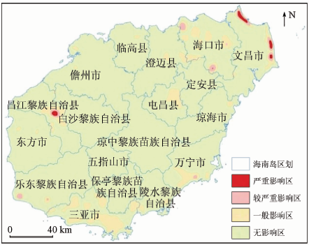
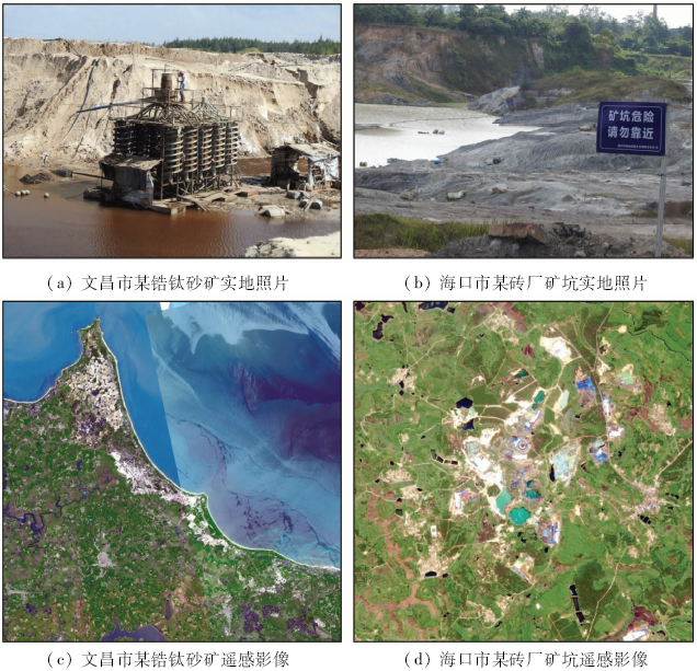
Abstract  

Analytic hierarchy process (AHP), as a comprehensive safety evaluation method combined with qualitative analysis, has been used in many fields of safety and environmental science. Problems of environmental geology in mines are affected by many factors. This study focuses on the ecological environment evaluation of the mine by using data on land occupied and damaged by mines, according to the characteristics of mining combined with relevant information of Hainan Island. Ultimately, mining environmental grade is divided into four levels. Through field examination and verification, it is found that the theoretical value is very compatible with the actual situation. The results show that the weight calculated by this method is scientific and reasonable, and the evaluation is objective. This method is worth popularizing in mine environment evaluation.

Keywords AHP      weights      geology environment      evaluation     
:  TP79  
Issue Date: 14 March 2020
Service
E-mail this article
E-mail Alert
RSS
Articles by authors
Yuling ZHAO
Cite this article:   
Yuling ZHAO. Study and application of analytic hierarchy process of mine geological environment: A case study in Hainan Island[J]. Remote Sensing for Land & Resources, 2020, 32(1): 148-153.
URL:  
https://www.gtzyyg.com/EN/10.6046/gtzyyg.2020.01.20     OR     https://www.gtzyyg.com/EN/Y2020/V32/I1/148
评价系统A 评价因子P 分级
1级 2级 3级
自然地理C1 地形地貌P11 坡度为0°~20°的面积大于80% 其他 坡度为35°~90°的面积大于30%
降雨量P12 按年平均降雨量,划分为3级
植被覆盖度P13 植被覆盖度大于80% 植被覆盖度为30%~80% 植被覆盖度小于30%
区域重要程度P14 按照《矿山地质环境保护与治理恢复方案编制规范》,进行3级划分
基础地质C2 构造P21 断层长度小于50 m,褶皱不发育 其他 断层长度大于500 m,或者断层长度大于50 m且褶皱极其发育
岩性组合P22 硬质岩为主 软质岩为主 松散堆积物
边坡结构P23 顺坡 横向坡 逆坡
资源损毁C3 开采矿山密度P31 无开采矿山 开采矿山数量小于3 开采矿山数量大于等于3
开采强度P32 小于10万t/a 10~50万t/a 大于10万t/a
主要开采方式P33 无矿山 露天开采 地下开采
主要矿种P34 非金属矿或无矿山占地地区 能源矿 金属矿
占用土地比例P35 占地比例小于1% 占地比例1%~15% 占地比例大于15%
地质环境C4 地质灾害P41 0个 数量1~2个 数量大于等于3个
水体污染P42 轻微污染 严重污染
生态环境恢复治理P43 无矿山占地和地质灾害 ①矿山占地面积大于10%; ②有1个小型地质灾害 ①开采面、尾矿库面积大于10%; ②2个以上小型或1个以上大型地质灾害
Tab.1  Factors of mine geological environment
环境评价 自然地理 基础地质 资源损毁 地质环境 ωi
自然地理 1 2 0.125 0.166 7 0.067 7
基础地质 0.5 1 0.111 1 0.25 0.050 3
资源损毁 8 9 1 5 0.654 9
地质环境 6 4 0.2 1 0.227 1
Tab.2  Weight of standard layer matrix
自然地理 区域重
要程度
地形地貌 降雨量 植被覆
盖度
ωi
区域重要程度 1 5 4 4 0.583 4
地形地貌 0.2 1 1 0.5 0.111 2
降雨量 0.25 1 1 1 0.139 0
植被覆盖度 0.25 2 1 1 0.166 4
Tab.3  Weight of natural geography indicator layer matrix(C1-P)
基础地质 岩性组合 边坡结构 构造 ωi
岩性组合 1 0.333 3 0.25 0.122 0
边坡结构 3 1 0.5 0.319 6
构造 4 2 1 0.558 4
Tab.4  Weight of geology indicator layer matrix(C2-P)
资源损毁 开采
方式
开采矿
山密度
开采
强度
开采
矿种
占用土
地比例
ωi
开采方式 1 5 3 2 5 0.407 6
开采矿山密度 0.2 1 0.25 0.25 1 0.065 5
开采强度 0.333 3 4 1 0.25 0.5 0.118 4
开采矿种 0.5 4 4 1 4 0.304 8
占用土地比例 0.2 1 2 0.25 1 0.103 6
Tab.5  Weight of the breakdown of resources indicator layer matrix(C3-P)
地质环境 地质灾害 恢复治理 污染 ωi
地质灾害 1 0.333 3 0.25 0.126
恢复治理 3 1 1 0.416 1
污染 4 1 1 0.457 9
Tab.6  Weight of geological environment indicator layer matrix(C4-P)
评价因子 ωi 评价因子 ωi
开采方式 0.267 0 地质灾害 0.028 6
开采矿种 0.199 7 构造 0.028 1
污染 0.104 0 边坡结构 0.016 1
恢复治理 0.094 5 植被覆盖度 0.011 3
开采强度 0.077 6 降雨量 0.009 4
占用土地比例 0.067 8 地形地貌 0.007 5
开采矿山密度 0.042 9 岩性组合 0.006 1
区域重要程度 0.039 5
Tab.7  Weights table of indicator layer (A-P)
等级 级别名称 对应分值区间
0级 无影响区 [0,40]
1级 一般影响区 (40,50]
2级 较重影响区 (50,60]
3级 严重影响区 (60,100]
Tab.8  Classification table of mining environment
Fig.1  Comprehensive evaluation map of mine geological environment of Hainan Island
Fig.2  Filedwork photos and remote sensing images of typical mine geological environment affected areas
[1] 李东, 周可法, 孙卫东 , 等. BP神经网络和SVM在矿山环境评价中的应用分析[J]. 干旱区地理, 2015,38(1):128-134.
[1] Li D, Zhou K F, Sun W D , et al. Application of BP neural network and SVM in mine environmental assessment[J]. Arid Land Geography. 2015,38(1):128-134.
[2] 刘玥, 牛宏 . 基于模糊综合评判法的矿山地质环境质量评价——以陕南铅锌矿为例[J]. 环境保护科学, 2013,39(5):63-66.
[2] Liu Y, Niu H . Evaluation of geo-environment quality of mining area based on fuzzy comprehensive evaluation method:Taking southern Shanxi lead-zinc mine Area as an example[J]. Environmental Protection Science, 2013,39(5):63-66.
[3] 蒋复量, 周科平, 李向阳 , 等. 基于集对分析的矿山地质环境影响评价研究[J]. 矿冶工程, 2009,29(2):1-4.
[3] Jiang F L, Zhou K P, Li X Y , et al. Study on assessment of geological environment impact in mines based on set pair analysis[J]. Mining and Metallurgical Engineering, 2009,29(2):1-4.
[4] 秦吉, 张翼鹏 . 现代统计信息分析技术在安全工程方面的应用——层次分析法原理[J]. 工业安全与防尘, 1999,25(5):44-48.
[4] Qin J, Zhang Y P . Application of modern statistical information analysis technology in safety engineering:Principle of AHP[J]. Industrial Safety and Dust Control, 1999,25(5):44-48.
[5] 王炳强, 沈智慧, 白喜庆 , 等. 层次分析法(AHP)在矿山环境地质评价中的应用[J]. 中国煤田地质, 2007,19(z2):57-59.
[5] Wang B Q, Shen Z H, Bai X Q , et al. Application of AHP in mine environmental geological evaluation[J]. Coal Geology of China, 2007,19(z2):57-59.
[6] 虞晓芬, 傅玳 . 多指标综合评价方法综述[J]. 统计与决策, 2004(11):119-121.
[6] Yu X F, Fu D . Synjournal of multiple indicator comprehensive evaluation methods[J]. Statistics and Decision, 2004(11):119-121.
[7] 常建娥, 蒋太立 . 层次分析法确定权重的研究[J]. 武汉理工大学学报(信息与管理工程版), 2007,29(1):153-156.
[7] Chang J E, Jiang T L . Research on the weight of coefficient through analytic hierarchy process[J]. Journal of Wuhan University of Technology(Information & Management Engineering), 2007,29(1):153-156.
[8] 骆正清, 杨善林 . 层次分析法中几种标度的比较[J]. 系统工程理论与实践, 2004(9):51-60.
[8] Luo Z Q, Yang S L . Comparative study on several scales in AHP[J]. Systems Engineering Theory and Practice. 2004(9):51-60.
[9] 陈桥, 胡克, 雒昆利 , 等. 基于AHP法的矿山生态环境综合评价模式研究[J]. 中国矿业大学学报. 2006,35(3):377-383.
[9] Chen Q, Hu K, Luo K L , et al. Study on the synthetical assessment model of mine eco-environments based on AHP[J]. Journal of China University of Mining & Technology. 2006,35(3):377-383.
[10] 海南省人民政府. 海南国际旅游岛建设发展规划纲要(2010—2020)[EB/OL]. (2013- 02- 25). http://mof.hainan.gov.cn/czt/zwxx/jhgh/201302/t20130225_911896.html.
url: http://mof.hainan.gov.cn/czt/zwxx/jhgh/201302/t20130225_911896.html
[10] The People’s Government of Hainan Province. Hainan International Tourism Island Construction and Development Plan Outline(2010-2020).[EB/OL]. (2013- 02- 25). http://mof.hainan.gov.cn/czt/zwxx/jhgh/201302/t20130225_911896.html.
url: http://mof.hainan.gov.cn/czt/zwxx/jhgh/201302/t20130225_911896.html
[11] 海南省人民政府.海南省总体规划(2015—2030)纲要内容摘要[EB/OL]( 2015- 09- 29). http://www.hainan.gov.cn/hn/yw/jrhn/201509/t20150928_1673673.html.
url: http://www.hainan.gov.cn/hn/yw/jrhn/201509/t20150928_1673673.html
[11] The People’s Government of Hainan Province. Summary of the Master Plan for Hainan Province[EB/OL] (2015- 09- 29). http://www.hainan.gov.cn/hn/yw/jrhn/201509/t20150928_1673673.html.
url: http://www.hainan.gov.cn/hn/yw/jrhn/201509/t20150928_1673673.html
[12] 刘晓晨, 张宁, 张敬凯 , 等. 层次分析法在矿山水环境质量评价中的应用[J]. 能源环境保护, 2008,22(4):51-53.
[12] Liu X C, Zhang N, Zhang J K , et al. Application of analytic hierarchy process method to quality evaluation of mine water environment[J]. Energy Environmental Protection, 2008,22(4):51-53.
[13] 陈振武, 曾志宏, 兰添才 , 等. 基于AHP的矿山指标自适应评价系统设计[J]. 龙岩学院学报, 2016,34(2):50-58.
[13] Chen Z W, Zeng Z H, Lan T C , et al. Design of adaptive evaluation system of mine ecological index based on AHP[J]. Journal of Longyan University, 2016,34(2):50-58.
[14] 马聪, 武文波 . 矿区生态环境评价系统研究与实现[J]. 测绘科学, 2009,34(s1):103-105.
[14] Ma C, Wu W B . Mining area ecological environment evaluation system design[J]. Science of Surveying and Mapping, 2009,34(s1):103-105.
[15] 国土资源部. DZ/T 0266—2014矿产资源开发遥感监测技术规范[S]. 北京:[s.n.], 2014.
[15] Ministry of Land and Resources. DZ/T 0266—2014 Regulation on Remote Sensing Monitoring of Mining Exploration[S]. Beijing:[s.n.], 2014.
[16] 赵玉灵 . 海南岛矿山地质环境遥感监测报告(2018年度)[R]. 北京,中国国土资源航空物探遥感中心, 2018.
[16] Zhao Y L . Remote Sensing Monitoring Report on Mine Geological Environment in Hainan Island[R]. Beijing,China Aero Geophysical Survey and Remote Sensing Center for Land and Resources, 2018.
[1] ZHANG Jinghua, OUYANG Yuan, LIU Hong, HUANG Hanxiao, ZHANG Tengjiao, LI Fu, LI Tong. Eco-geological vulnerability assessment based on major controlling factors: A case study of Xichang City, Sichuan Province[J]. Remote Sensing for Natural Resources, 2021, 33(4): 181-191.
[2] CHEN Chao, CHEN Huixin, CHEN Dong, ZHANG Zili, ZHANG Xufeng, ZHUANG Yue, CHU Yanli, CHEN Jianyu, ZHENG Hong. Coastline extraction and spatial-temporal variations using remote sensing technology in Zhoushan Islands[J]. Remote Sensing for Land & Resources, 2021, 33(2): 141-152.
[3] MIN Wenbin, PEN Jun, Li Shiying. The evaluation of FY-3C snow products in the Tibetan Plateau[J]. Remote Sensing for Land & Resources, 2021, 33(1): 145-151.
[4] GAO Junhua, LIU Shasha, YANG Jinzhong, ZHAO Mingpeng, LIU Xinyue, ZOU Lianxue. Gray correlation evaluation of geological environment in the open-pit coal mine concentration area based on remote sensing:A case study of the Zhungeer Coalfield[J]. Remote Sensing for Land & Resources, 2021, 33(1): 183-190.
[5] CHEN Zhen, XIA Xueqi, CHEN Jianping. A study of remote sensing evaluation model and main controlling factors of land ecological quality:A case study of Guang’an City[J]. Remote Sensing for Land & Resources, 2021, 33(1): 191-198.
[6] FAN Jiazhi, LUO Yu, TAN Shiqi, MA Wen, ZHANG Honghao, LIU Fulai. Accuracy evaluation of the FY-3C/MWRI land surface temperature product in Hunan Province[J]. Remote Sensing for Land & Resources, 2021, 33(1): 249-255.
[7] YAO Kun, ZHANG Cunjie, HE Lei, LI Yuxia, LI Xiaoju. Dynamic evaluation and prediction of ecological environment vulnerability in the middle-upper reaches of the Yalong River[J]. Remote Sensing for Land & Resources, 2020, 32(4): 199-208.
[8] WEN Yanan, CHE Yahui, GUANG Jie, ZHANG Xiaomei, LI Zhengqiang. Quality evaluation of forest cover products over China[J]. Remote Sensing for Land & Resources, 2020, 32(3): 32-38.
[9] DONG Jiaji, REN Huazhong, ZHENG Yitong, NIE Jing, MENG Jinjie, QIN Qiming. A study of the livability of urban environment based on multi-source remote sensing data: A case study of Beijing City[J]. Remote Sensing for Land & Resources, 2020, 32(3): 165-172.
[10] Liping YANG, Meng MA, Wei XIE, Xueping PAN. Fusion algorithm evaluation of Landsat 8 panchromatic and multispetral images in arid regions[J]. Remote Sensing for Land & Resources, 2019, 31(4): 11-19.
[11] Linlin WU, Yunlan GUAN, Jiawei LI, Chenxin YUAN, Rui LI. Assessment of Karst rocky desertification based on MODIS: Exemplified by Guizhou Province[J]. Remote Sensing for Land & Resources, 2019, 31(4): 235-242.
[12] Yu ZHANG, Xiaoli ZHAO, Lijun ZUO, Zengxiang ZHANG, Jinyong XU. The impact of land use change on ecosystem services value in Loess Plateau[J]. Remote Sensing for Land & Resources, 2019, 31(3): 132-139.
[13] Xiaodong ZHANG, Xiangnan LIU, Zhipeng ZHAO, Dan WU, Wenzhong WU, Xiaodong CHU. Geological disaster hazard assessment in Yanchi County based on AHP[J]. Remote Sensing for Land & Resources, 2019, 31(3): 183-192.
[14] Jiaping WU, Yang ZHANG, Jie ZHANG, Shenglong FAN, Chao YANG, Xiaofang ZHANG. Comparison and analysis of water indexes in muddy coasts based on MODIS data: A case study of the Yellow River Delta coast[J]. Remote Sensing for Land & Resources, 2019, 31(3): 242-249.
[15] Qiao HUANG, Yuling PENG, Wenjie QIN. Research on land use suitability evaluation: A case study of Savan water economic zone in Laos[J]. Remote Sensing for Land & Resources, 2018, 30(4): 156-162.
Viewed
Full text


Abstract

Cited

  Shared   
  Discussed   
京ICP备05055290号-2
Copyright © 2017 Remote Sensing for Natural Resources
Support by Beijing Magtech