|
|
|
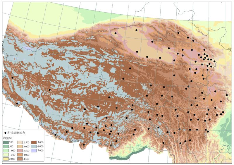
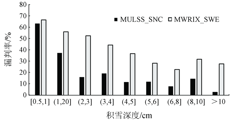
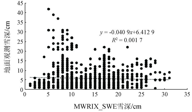
Abstract In order to understand the regional reliability of the Fengyun-3C(FY-3C) satellite snow products, the authors used the snow cover data of 118 meteorological stations in the Tibetan Plateau from October 1, 2018 to April 30, 2019 to evaluate the snow cover (MULSS_SNC) and snow water equivalent (MWRIX_SWE) products. The results show that, for snow cover pixels of MULSS_SNC and MWRIX_SWE, the accuracy rate is 87.18% and 72.32% respectively, the recall rate is 66.67% and 49.63% respectively, the false rate is 12.81% and 27.68% respectively, and the missing rate is 33.33% and 50.37% respectively. In terms of mixed pixels or pixels with snow depth less than 0.5 cm, both MULSS_SNC and MWRIX_SWE tend to identify with no snow, and the missing rate of snow depth less than 1cm is up to 60%. When the snow depth of MULSS_SNC is more than 2cm, the recall rate can reach 89.09%. However, for MWRIX_SWE, only when the snow depth is more than 5cm can the snow recall rate reach 63.37%. The snow depth in the Tibetan Plateau from MWRIX_SWE has a large error with ground observations, and there is no linear positive correlation, so it is not recommended to use it directly.
|
| Keywords
MULSS_SNC
MWRIX_SWE
evaluation
Tibetan Plateau
|
|
|
|
Issue Date: 18 March 2021
|
|
|
| [1] |
李震, 张文煜, 孙文新, 等. NOAA/AVHRR数据的雪盖信息提取与复台[J]. 遥感技术与应用, 1995,10(4):19-24.
|
| [1] |
Li Z, Zhang W Y, Sun W X. Extracting the information of snow-cover from NOAA/AVHRR data and overlaying with vector data[J]. Remote Sensing Technology and Application, 1995,10(4):19-24.
url: http://www.rsta.ac.cn/CN/abstract/abstract1373.shtml
|
| [2] |
延昊, 张国平. 混合像元分解法提取积雪盖度[J]. 应用气象学报, 2004,15(6):665-671.
|
| [2] |
Yan H, Zhang G P. Unmixing method applied to NOAA/AVHRR data for snow cover estimation[J]. Journal of Applied Meteorological Science, 2004,15(6):665-671.
|
| [3] |
梁天刚, 吴彩霞, 陈全功, 等. 北疆牧区积雪图像分类与雪深反演模型的研究[J]. 冰川冻土, 2004,26(2):160-165.
|
| [3] |
Liang T G, Wu C X, Chen Q G, et al. Snow classification and monitoring models in the pastoral areas of the Northern Xinjiang[J]. Journal of Glaciology and Geocryology, 2004,26(2):160-165.
|
| [4] |
张永宏, 任伟, 曹庭, 等. FY-3/VIRR资料积雪多阈值综合判识方法研究[J]. 遥感技术与应用, 2015,30(6):1076-1084.
|
| [4] |
Zhang Y H, Ren W, Cao T, et al. Method of snow multi-threshold comprehensive discrimination with FY-3/VIRR data[J]. Remote Sensing Technology and Application, 2015,30(6):1076-1084.
|
| [5] |
陈文倩, 丁建丽, 孙永猛, 等. 基于NDSI-NDVI特征空间的积雪面积反演研究[J]. 冰川冻土, 2015,37(4):1059-1066.
|
| [5] |
Chen W Q, Ding J L, Sun Y M, et al. Retrieval of snow cover area based on NDSI-NDVI feature space[J]. Journal of Glaciology and Geocryology, 2015,37(4):1059-1066.
|
| [6] |
庞海洋, 孔祥生, 汪丽丽, 等. ENDSI增强型雪指数提取积雪研究[J]. 国土资源遥感, 2018,30(1):63-71.doi: 10.6046/gtzyyg.2018.01.09.
|
| [6] |
Pang H Y, Kong X S, Wang L L, et al. A study of the extraction of snow cover using nonlinear ENDSI model[J]. Remote Sensing for Land and Resources, 2018,30(1):63-71.doi: 10.6046/gtzyyg.2018.01.09.
|
| [7] |
王功雪, 蒋玲梅, 武胜利, 等. FY-3B与FY-3C/MWRI交叉定标及雪深算法应用[J]. 遥感技术与应用, 2017,32(1):49-56.
|
| [7] |
Wang G X, Jiang L M, Wu S L, et al. Intercalibrating FY-3B and FY-3C/MWRI for synergistic implementing to snow depth retrieval algorithm[J]. Remote Sensing Technology and Application, 2017,32(1):49-56.
|
| [8] |
李长春, 徐轩, 包安明, 等. 基于FY3B-MWRI数据新疆区域积雪深度反演[J]. 遥感技术与应用, 2018,33(6):1030-1036.
|
| [8] |
Li C C, Xu X, Bao A M, et al. The study on snow depth retrieval in Xinjiang region based on FY3B-MWRI data[J]. Remote Sensing Technology and Application, 2018,33(6):1030-1036.
|
| [9] |
沙依然, 外力, 毛炜峄. 基于AMSR2被动微波积雪参量高精度反演方法研究[J]. 冰川冻土, 2016,38(1):145-158.
|
| [9] |
Sayran W L, Mao W Y. A research on the method of deriving high-precision snow parameters from AMSR2 passive microwave remote sensing data[J]. Journal of Glaciology and Geocryology, 2016,38(1):145-158.
|
| [10] |
陈鹤, 车涛, 戴礼云. 基于FY-MWRI的中国西部被动微波积雪判识算法[J]. 遥感技术与应用, 2018,33(6):1037-1045.
|
| [10] |
Chen H, Che T, Dai L Y. Snow identification algorithm based on FY-MWRI in Western China[J]. Remote Sensing Technology and Application, 2018,33(6):1037-1045.
|
| [11] |
文军, Dai Mo, Deroin Jean-Paul, 等. 利用MODIS和ASAR资料估算青藏高原念青唐古拉山脉地区冰雪范围及厚度[J]. 冰川冻土, 2006,28(1):54-61.
|
| [11] |
Wen J, Dai M, Deroin J P, et al. Extent and depth of snow cover over the Nyainqêntanglha Range derived from ASAR and MODIS data[J]. Journal of Glaciology and Geocryology, 2006,28(1):54-61.
|
| [12] |
孙燕华, 黄晓东, 王玮, 等. 青藏高原积雪及雪水当量的时空变化[J]. 冰川冻土, 2014,36(6):1337-1344.
|
| [12] |
Sun Y H, Huang X D, Wang W, et al. Spatio-temporal changes of snow cover and snow water equivalent in the Tibetan Plateau during 2003-2010[J]. Journal of Glaciology and Geocryology, 2014,36(6):1337-1344.
|
| [13] |
除多, 达娃, 拉巴卓玛, 等. 基于MODIS数据的青藏高原积雪时空分布特征分析[J]. 国土资源遥感, 2017,29(2):117-124.doi: 10.6046/gtzyyg.2017.02.17.
|
| [13] |
Chu D, Da W, Laba Z M, et al. An analysis of spatial-temporal distribution features of snow cover over the Tibetan Plateau based on MODIS data[J]. Remote Sensing for Land and Resources, 2017,29(2):117-124.doi: 10.6046/gtzyyg.2017.02.17.
|
| [14] |
Wang X W, Xie H J, Liang T G, et al. Comparison and validation of MODIS standard and new combination of Terra and Aqua snow cover products in Northern Xinjiang,China[J]. Hydrological Processes, 2009,23(3):419-429.
|
| [15] |
柏延臣, 冯学智, 李新, 等. 基于被动微波遥感的青藏高原雪深反演及其结果评价[J]. 遥感学报, 2001,5(3):161-165.
|
| [15] |
Bo Y C, Feng X Z, Li X, et al. The retrieval of snow depth in Qinghai-Xizang (Tibet) Plateau from passive microwave remote sensing data and its results assessment[J]. Journal of Remote Sensing, 2001,5(3):161-165.
|
| [16] |
肖雄新, 张廷军. 基于被动微波遥感的积雪深度和雪水当量反演研究进展[J]. 地球科学进展, 2018,33(6):590-605.
|
| [16] |
Xiao X X, Zhang T J. Passive microwave remote sensing of snow depth and snow water equivalent:Overview[J]. Advances in Earth Science, 2018,33(6):590-605.
|
| [17] |
蒋洪波, 秦其明, 张宁, 等. 不同积雪深度与面积对积雪覆盖遥感反演的影响[J]. 光谱学与光谱分析, 2011,31(12):3342-3346.
pmid: 22295791
|
| [17] |
Jiang H B, Qin Q M, Zhang N, et al. Effect of different snow depth and area on the snow cover retrieval using remote sensing data[J]. Spectroscopy and Spectral Analysis, 2011,31(12):3342-3346.
pmid: 22295791
url: https://www.ncbi.nlm.nih.gov/pubmed/22295791
|
| [18] |
晋锐, 李新, 马明国, 等. 陆地定量遥感产品的真实性检验关键技术与试验验证[J]. 地球科学进展, 2017,32(6):630-642.
|
| [18] |
Jin R, Li X, Ma M G, et al. Key methods and experiment verification for the validation of quantitative remote sensing products[J]. Advances in Earth Science, 2017,32(6):630-642.
|
| [19] |
王轩, 郝晓华, 王建, 等. 中国地区AVHRR长时间序列积雪范围产品精度评估[J]. 遥感技术与应用, 2018,33(6):994-1003.
|
| [19] |
Wang X, Hao X H, Wang J, et al. Accuracy evaluation of long time series AVHRR snow cover area products in China[J]. Remote Sensing Technology and Application, 2018,33(6):994-1003.
|
| [20] |
侯小刚, 郑照军, 李帅, 等. 近15年新疆逐日无云积雪覆盖产品生成及精度验证[J]. 国土资源遥感, 2018,30(2):214-222.doi: 10.6046/gtzyyg.2018.02.29.
|
| [20] |
Hou X G, Zheng Z J, Li S, et al. Generation of daily cloudless snow cover product in the past 15 years in Xinjiang and accuracy validation[J]. Remote Sensing for Land and Resources, 2018,30(2):214-222.doi: 10.6046/gtzyyg.2018.02.29.
|
|
Viewed |
|
|
|
Full text
|
|
|
|
|
Abstract
|
|
|
|
|
Cited |
|
|
|
|
| |
Shared |
|
|
|
|
| |
Discussed |
|
|
|
|
 2021,
Vol. 33
2021,
Vol. 33
 ), PEN Jun1, Li Shiying2