|
|
 |
|

|
|
|
Denoising algorithm based on the fusion of lifting wavelet thresholding and multidirectional edge detection of remote sensing image of mining area |
WANG Xiaobing1,2,3( ) ) |
1. Sinosteel Maanshan General Institute of Mining Research Co., Ltd., Maanshan 243000, China
2. State Key Laboratory of Safety and Health for Metal Mines, Maanshan 243000, China
3. Huawei National Engineering Research Center of High Efficient Cyclic and Utilization of Metallic Mineral Resources Co., Ltd., Maanshan 243000, China |
|
|
|
|
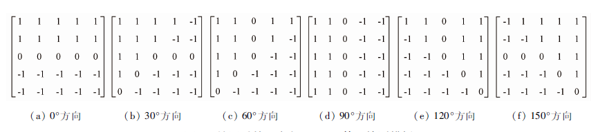
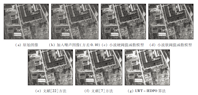
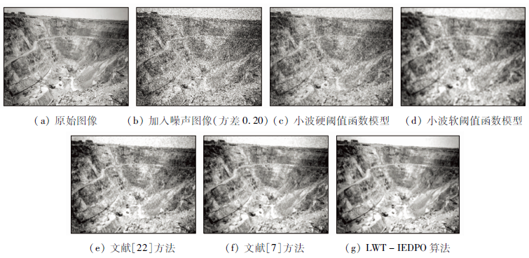
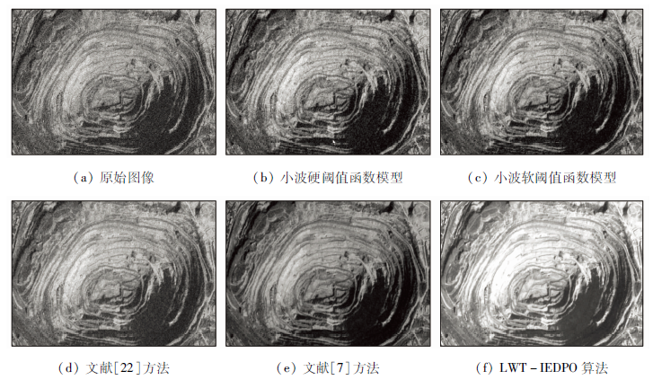
Abstract Remote sensing image plays an important role in ecological restoration, geological disaster monitoring and prevention of mining area; nevertheless, due to the complex environment of mining area, the obtained remote sensing images of the mining area contains different kinds of intensity noise, which affects the subsequent image interpretation and analysis to a great extent. In this paper, the study ideas of image edge detection and noise suppression are effectively fused together, and the improved denoising method (LWT-IEDPO) of remote sensing image in mining area based on the fusion of lifting wavelet thresholding (LWT) and improved edge dectction of Prewitt operator (IEDPO) is proposed. According to the basic principal of the new method proposed in this paper, firstly, lifting wavelet transform is done for the original remote sensing image; under the condition that the low-frequency wavelet sub-band is left untreated, a two-parameters thresholding function model is designed for adaptive noise suppression of high-frequency sub-bands, and the remote sensing image after initial denoising is obtained by the operation of inverse lifting wavelet transform. Secondly, for the purpose of effectively enhancing the details of the filtered remote sensing image, the detection template of the classical Prewitt operator is extended to 6 directions of 0°, 30°, 60°, 90°, 120° and 150°, and the corresponding detection results fusion rules are proposed. The improved Prewitt operator is put forward to extract the image edge information of the filtered image, and the edge and non-edge image are obtained. Then, the visual effect non-edge image is further improved by adopting the improved Pal-King fuzzy algorithm. Finally, the goal of high definition restoration of the original remote sensing image is realized by the superimposition of the enhanced non-edge image and edge image. Based on MATLAB language, the proposed remote sensing image processing method is compared with the classical hard thresholding model, soft thresholding model and two existing improved wavelet thresholding algorithms; in addition, the two indices of peak signal to noise ratio (PSNR) and edge protection index (EPI) are used to conduct quantitative analysis and comparison of the performance of the above algorithms. The study results show that the goal of effectively filtering of noise remote sensing image can be realized effectively, and the overall performance of the proposed algorithm is better than that of the other four algorithms.
|
| Keywords
image processing
remote sensing image
lifting wavelet transform
Prewitt operator
image inhancement
|
|
|
|
Issue Date: 23 December 2020
|
|
|
| [1] |
姚薇, 钱玲玲. 矿山遥感图像自适应加权改进中值滤波算法[J]. 金属矿山, 2016(4):101-105.
|
| [1] |
Yao W, Qian L L. Adaptive weighted improved median filtering algorithm of mine remote sensing image[J]. Metal Mine, 2016(4):101-105.
|
| [2] |
张元军. 基于双边滤波与小波阈值法的矿区遥感图像处理[J]. 金属矿山, 2017(9):170-173.
|
| [2] |
Zhang Y J. Remote sensing image processing method of mining area based on bilateral filtering algorithm and wavelet thresholding method[J]. Metal Mine, 2017(9):170-173.
|
| [3] |
任超, 李现广, 邓开元, 等. 结合BM3D和多级非线性加权平均中值滤波的遥感影像混合噪声去噪方法[J]. 测绘通报, 2020(1):89-93.
|
| [3] |
Ren C, Li X G, Deng K Y, et al. Mixed noise denoising method for remote sensing images combining BM3D and multi-level nonlinear weighted average median filtering[J]. Bulletin of Surveying and Mapping, 2020(1):89-93.
|
| [4] |
高飞, 朱磊, 冯子金, 等. 基于变差系数的SAR图像非局部均值滤波算法[J]. 信息通信, 2019(10):42-44.
|
| [4] |
Gao F, Zhu L, Feng Z J, et al. Non-local mean filtering algorithm for SAR image based on coefficient of variation[J]. Information and Communications, 2019(10):42-44.
|
| [5] |
陈清江, 石小涵, 柴昱洲. 基于小波变换与卷积神经网络的图像去噪算法[J]. 应用光学, 2020,41(2):288-295.
|
| [5] |
Chen Q J, Shi X H, Chai Y Z. Image denoising algorithm based on wavelet transform and convolutional neural network[J]. Journal of Applied Optics, 2020,41(2):288-295.
|
| [6] |
魏江, 刘潇, 梅少辉. 基于卷积神经网络的遥感图像去噪算法[J]. 微电子学与计算机, 2019,36(8):59-62,67.
|
| [6] |
Wei J, Liu X, Mei S H. Remote sensing image denoising based on convolutional neural network[J]. Microelectronics and Computer, 2019,36(8):59-62,67.
|
| [7] |
陈竹安, 胡志峰. 小波阈值改进算法的遥感图像去噪[J]. 测绘通报, 2018(4):28-31.
|
| [7] |
Chen Z A, Hu Z F. Remote sensing image denoising based on improved wavelet threshold algorithm[J]. Bulletin of Surveying and Mapping, 2018(4):28-31.
|
| [8] |
张倩. 基于双重离散小波变换的遥感图像去噪算法[J]. 国土资源遥感, 2015,27(4):14-20.doi: 10.6046/gtzyyg.2015.04.03.
|
| [8] |
Zhang Q. Remote sensing image de-noising algorithm based on double discrete wavelet transform[J]. Remote Sensing for Land and Resources, 2015,27(4):14-20.doi: 10.6046/gtzyyg.2015.04.03.
|
| [9] |
刘尚旺, 郜刘阳, 王博. 联合双边滤波器和小波阈值收缩去噪算法研究[J]. 国土资源遥感, 2018,30(2):114-124.doi: 10.6046/gtzyyg.2018.02.16.
|
| [9] |
Liu S W, Gao L Y, Wang B. Research on image denoising algorithm of joint bilateral filter and wavelet threshold shrinkage[J]. Remote Sensing for Land and Resources, 2018,30(2):114-124.doi: 10.6046/gtzyyg.2018.02.16.
|
| [10] |
徐冬, 孙蕾, 罗建书. 结合NAPCA和复小波变换的高光谱遥感图像去噪[J]. 红外与激光工程, 2015,44(1):327-334.
|
| [10] |
Xu D, Sun L, Luo J S. Denoising of hyperspectral remote sensing imagery using NAPCA and complex wavelet transform[J]. Infrated and Laser Engineering, 2015,44(1):327-334.
|
| [11] |
黄涛, 薛丰昌, 钱洪亮, 等. 基于NSCT和自适应模糊阈值遥感图像去噪算法[J]. 计算机技术与发展, 2016,26(1):65-69.
|
| [11] |
Huang T, Xue F C, Qian H L, et al. Remote sensing image denoising algorithm based on NSCT and adaptive fuzzy threshold[J]. Computer Technology and Development, 2016,26(1):65-69.
|
| [12] |
丁海勇, 郭瑞瑞, 罗海滨. 顾及纹理信息的遥感图像NSCT域自适应阈值去噪[J]. 遥感技术与应用, 2017,32(3):435-442.
|
| [12] |
Ding H Y, Guo R R, Luo H B. Denoising of remote sensing images using adaptive threshold in NSCT domain by concerning texture information[J]. Remote Sensing Technology and Application, 2017,32(3):435-442.
|
| [13] |
袁明月, 魏悦, 孙伟, 等. 一种改进的遥感影像去噪综合模型[J]. 北京测绘, 2019,33(7):776-780.
|
| [13] |
Yuan M Y, Wei Y, Sun W, et al. An improved model of remote sensing image denoising[J]. Beijing Surveying and Mapping, 2019,33(7):776-780.
|
| [14] |
王小兵, 孙久运, 汤海燕. 一种基于数学形态学与小波域增强的滤波算法[J]. 微电子学与计算机, 2012,29(7):64-67.
|
| [14] |
Wang X B, Sun J Y, Tang H Y. A new filter algorithm based on mathematical morphology and wavelet domain enhancement[J]. Microelectronics and Computer, 2012,29(7):64-67.
|
| [15] |
王小兵, 孙久运, 汤海燕. 基于小波变换的图像混合噪声自适应滤波算法[J]. 微电子学与计算机, 2012,29(6):91-95.
|
| [15] |
Wang X B, Sun J Y, Tang H Y. Adaptive filtering algorithm for mixed noise image based on wavelet transform[J]. Microelectronics and Computer, 2012,29(6):91-95.
|
| [16] |
王小兵, 姚雪晴, 邱银国, 等. 一种新型煤矿视频监控图像滤波算法[J]. 工矿自动化, 2014,40(11):76-80.
|
| [16] |
Wang X B, Yao X Q, Qiu Y G, et al. A new filtering algorithm for video monitoring image of coal mine[J]. Industry and Mine Automation, 2014,40(11):76-80.
|
| [17] |
王小兵, 孙久运. 一种新型高斯噪声滤波算法[J]. 北华大学学报(自然科学版), 2011,12(5):606-609.
|
| [17] |
Wang X B, Sun J Y. A new Gaussian noise filtering algorithm[J]. Journal of Beihua University(Natural Science), 2011,12(5):606-609.
|
| [18] |
王小兵, 孙久运, 汤海燕. 一种高斯噪声组合滤波方法[J]. 佳木斯大学学报(自然科学版), 2011,29(5):696-698.
|
| [18] |
Wang X B, Sun J Y, Tang H Y. A mixed filter method on Gaussian noise[J]. Journal of Jiamusi University(Natural Science Edition), 2011,29(5):696-698.
|
| [19] |
王延霞, 曹传龙, 李鹏, 等. 提升小波变换的部分残差相位模拟与去除[J]. 测绘科学, 2019,44(10):165-171.
|
| [19] |
Wang Y X, Cao C L, Li P, et al. Part of residual phase simulation and purify based on the lifting wavelet transform method[J]. Science of Surveying and Mapping, 2019,44(10):165-171.
|
| [20] |
Zhang L B, Chen J, Qiu B C. Region of interest extraction in remote sensing images by saliency analysis with the normal directional lifting wavelet transform[J]. Neurocomputing, 2016,179:186-201.
doi: 10.1016/j.neucom.2015.11.093
url: https://linkinghub.elsevier.com/retrieve/pii/S0925231215019384
|
| [21] |
董雪, 林志贤, 郭太良. 基于LoG算子改进的自适应阈值小波去噪算法[J]. 液晶与显示, 2014,29(2):275-280.
doi: 10.3788/YJYXS20142902.0275
url: http://www.yjyxs.com/CN/abstract/abstract9665.shtml
|
| [21] |
Dong X, Lin Z X, Guo T L. Improved self-adaptive threshold wavelet denoising analysis based on LoG operator[J]. Chinese Journal of Liquid Crystals and Displays, 2014,29(2):275-280.
doi: 10.3788/YJYXS20142902.0275
url: http://www.yjyxs.com/CN/abstract/abstract9665.shtml
|
| [22] |
纪峰, 李翠, 常霞, 等. 基于改进阈值函数的自适应图像去噪方法[J]. 传感技术学报, 2014,27(3):351-354.
|
| [22] |
Ji F, Li C, Chang X, et al. Adaptive image denoising based on the improved threshold function[J]. Chinese Journal of Sensors and Actuators, 2014,27(3):351-354.
|
| [23] |
Zhou R G, Yu H, Cheng Y, et al. Quantum image edge extraction based on improved Prewitt operator[J]. Quantum Information Processing, 2019,18(9):1-24.
|
| [24] |
Tian X S. A novel image edge detection algorithm based on Prewitt operator and wavelet transform[J]. International Journal of Advancements in Computing Technology, 2012,19(4):73-82.
|
| [25] |
许健才. 一种非下采样轮廓波变换域水果图像预处理方法[J]. 江苏农业科学, 2015,43(11):499-501.
|
| [25] |
Xu J C. A pre-processing method for fruit image in non-subsampled contourlet transform domain[J]. Jiangsu Agricultural Sciences, 2015,43(11):499-501.
|
| [26] |
周自顾, 曹杰, 郝群, 等. 保留边界特征的深度图像增强算法研究[J]. 应用光学, 2018,39(2):200-206.
|
| [26] |
Zhou Z G, Cao J, Hao Q, et al. Depth image enhancement algorithm for preserving boundary[J]. Journal of Applied Optics, 2018,39(2):200-206.
|
| [27] |
李贺, 秦志远, 周丽雅. SAR图像斑点噪声整体变分偏微分方程滤波算法研究[J]. 中国图象图形学报, 2010,15(6):910-914.
|
| [27] |
Li H, Qin Z Y, Zhou L Y. Study on SAR image speckle noise smoothing algorithm with TV-PDE[J]. Journal of Image and Grapics, 2010,15(6):910-914.
|
|
Viewed |
|
|
|
Full text
|
|
|
|
|
Abstract
|
|
|
|
|
Cited |
|
|
|
|
| |
Shared |
|
|
|
|
| |
Discussed |
|
|
|
|
 2020,
Vol. 32
2020,
Vol. 32