|
|
 |
|

|
|
|
A random forest-based method integrating indices and principal components for classifying remote sensing images |
LIANG Jintao1( ), CHEN Chao2(), ZHANG Zili3, LIU Zhisong4 ), CHEN Chao2(), ZHANG Zili3, LIU Zhisong4 |
1. Marine Science and Technology College, Zhejiang Ocean University, Zhoushan 316022, China
2. School of Geography Science and Geomatics Engineering, Suzhou University of Science and Technology, Suzhou 215009, China
3. Zhejiang Ecological and Environmental Monitoring Center (Zhejiang Key Laboratory of Ecological and Environmental Monitoring, Forewarning and Quality Control), Hangzhou 310012, China
4. School of Information Engineering, Zhejiang Ocean University, Zhoushan 316022, China |
|
|
|
|
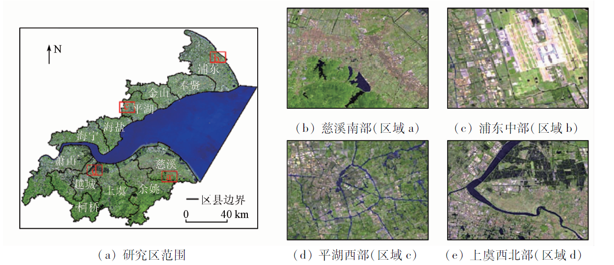
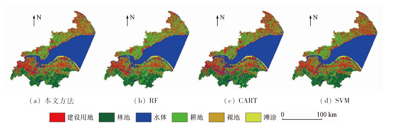
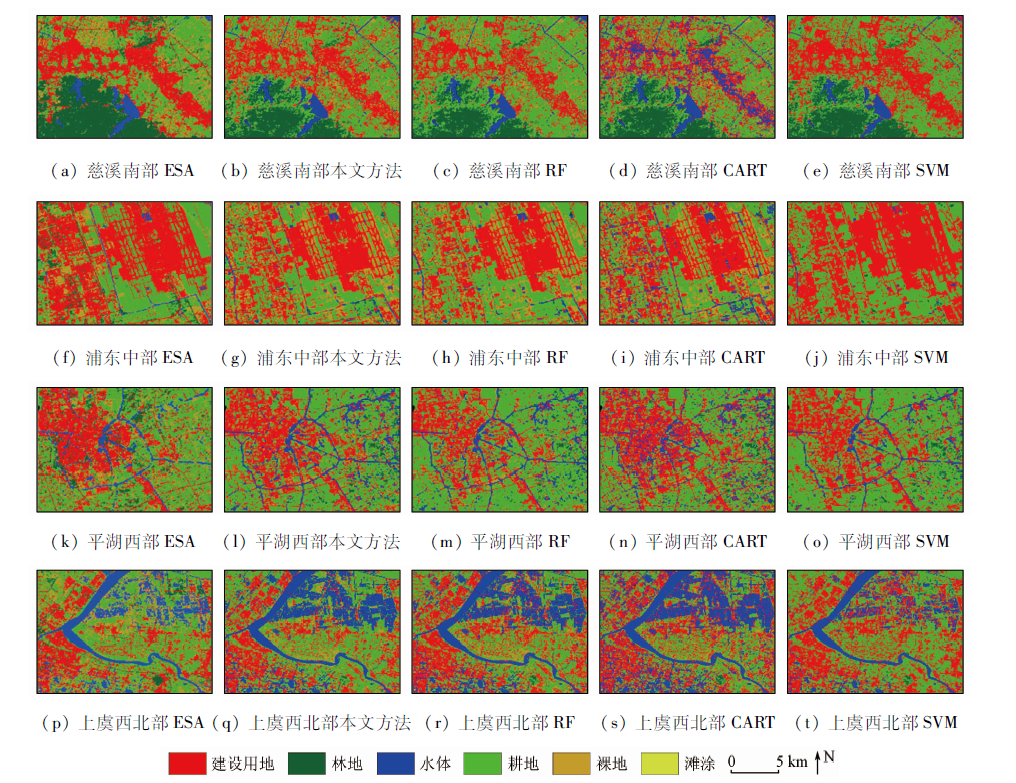
Abstract Accurate information about land use/land cover (LULC) can provide significant guidance for regional spatial planning and sustainable development. However, conventional methods for remote sensing image classification are challenging due to complex surface morphologies, diverse surface feature types, and nonlinear features of remote sensing images. Therefore, they fail to fully utilize the rich information in remote sensing images. This study developed a random forest-based classification method for remote sensing images to extract LULC information by integrating indices and principal components. First, the images covering the study area were selected to determine cloud cover and conduct median synthesis of images, obtaining interannual remote sensing images. Then, various calculated indices and the extracted principal components were integrated into the band stacks of remote sensing images. Furthermore, classifiers were constructed using different machine-learning algorithms. Finally, based on a confusion matrix, the classification results were evaluated using overall accuracy and the Kappa coefficient. The experimental results of the Hangzhouwan area show that the decision support based on vegetation, water, building indices, and principal components can improve the classification accuracy, yielding overall accuracy and Kappa coefficient of 91.42% and 0.894 2, respectively, which were higher than those of conventional methods such as random forest, classification and regression tree, and support vector machine. The method for remote sensing image classification proposed in this study, which integrates indices and principal components, can obtain high-accuracy land use classification results by accurately extracting land cover features in remote sensing images. This study will provide method support for fine-scale surface classification.
|
| Keywords
random forest
land use/land cover
index
principal component analysis
accuracy evaluation
|
|
|
|
Issue Date: 19 September 2023
|
|
|
| [1] |
Rawat J S, Kumar M. Monitoring land use/cover change using remote sensing and GIS techniques:A case study of Hawalbagh Block,District Almora,Uttarakhand,India[J]. The Egyptian Journal of Remote Sensing and Space Science, 2015, 18(1):77-84.
doi: 10.1016/j.ejrs.2015.02.002
url: https://linkinghub.elsevier.com/retrieve/pii/S1110982315000034
|
| [2] |
Yao J, Wu J, Xiao C, et al. The classification method study of crops remote sensing with deep learning,machine learning,and Google Earth Engine[J]. Remote Sensing, 2022, 14(12):2758.
doi: 10.3390/rs14122758
url: https://www.mdpi.com/2072-4292/14/12/2758
|
| [3] |
杨耘, 徐丽, 颜佩丽. 条件随机场框架下基于随机森林的城市土地利用/覆盖遥感分类[J]. 国土资源遥感, 2014, 26(4):51-55.doi:10.6046/gtzyyg.2014.04.09.
doi: 10.6046/gtzyyg.2014.04.09
|
| [3] |
Yang Y, Xu L, Yan P L. Urban land use/cover remote sensing classification based on random forest under conditional random field framework[J]. Remote Sensing for Land and Resources, 2014, 26(4):51-55.doi:10.6046/gtzyyg.2014.04.09.
doi: 10.6046/gtzyyg.2014.04.09
|
| [4] |
熊华, 刘耀林, 车珊珊, 等. 基于支持向量机的土地利用变化模拟模型[J]. 武汉大学学报(信息科学版), 2009, 34(3):366-369.
|
| [4] |
Xiong H, Liu Y L, Che S S, et al. Simulation model of land use change based on support vector machine[J]. Geomatics and Information Science of Wuhan University, 2009, 34(3):366-369.
|
| [5] |
杨曦光, 黄海军, 严立文, 等. 基于决策树方法的海岛土地利用分类研究[J]. 国土资源遥感, 2012, 24(2):116-120.doi:10.6046/gtzyyg.2012.02.21.
doi: 10.6046/gtzyyg.2012.02.21
|
| [5] |
Yang X G, Huang H J, Yan L W, et al. Research on island land use classification based on decision tree method[J]. Remote Sensing for Land and Resources, 2012, 24(2):116-120.doi:10.6046/gtzyyg.2012.02.21.
doi: 10.6046/gtzyyg.2012.02.21
|
| [6] |
Bangira T, Alfieri S M, Menenti M, et al. Comparing thresholding with machine learning classifiers for mapping complex water[J]. Remote Sensing, 2019, 11(11):1351.
doi: 10.3390/rs11111351
url: https://www.mdpi.com/2072-4292/11/11/1351
|
| [7] |
Wu H, Lin A, Xing X, et al. Identifying core driving factors of urban land use change from global land cover products and POI data using the random forest method[J]. International Journal of Applied Earth Observation and Geoinformation, 2021, 103:102475.
doi: 10.1016/j.jag.2021.102475
url: https://linkinghub.elsevier.com/retrieve/pii/S0303243421001823
|
| [8] |
Rodriguez-Galiano V F, Ghimire B, Rogan J, et al. An assessment of the effectiveness of a random forest classifier for land-cover classification[J]. ISPRS Journal of Photogrammetry and Remote Sensing, 2012, 67:93-104.
doi: 10.1016/j.isprsjprs.2011.11.002
url: https://linkinghub.elsevier.com/retrieve/pii/S0924271611001304
|
| [9] |
武复宇, 王雪, 丁建伟, 等. 基于改进的多级联随机森林网络高光谱遥感影像分类[J]. 遥感学报, 2020, 24(4):439-453.
|
| [9] |
Wu F Y, Wang X, Ding J W, et al. Hyperspectral remote sensing image classification based on improved multi-cascade random forest network[J]. Journal of Remote Sensing, 2020, 24(4):439-453.
|
| [10] |
Ge G, Shi Z, Zhu Y, et al. Land use/cover classification in an arid desert-oasis mosaic landscape of China using remote sensed imagery:Performance assessment of four machine learning algorithms[J]. Global Ecology and Conservation, 2020, 22:e00971.
doi: 10.1016/j.gecco.2020.e00971
url: https://linkinghub.elsevier.com/retrieve/pii/S2351989420300202
|
| [11] |
肖湘文, 沈校熠, 柯长青, 等. 基于Sentinel-1A数据的多种机器学习算法识别冰山的比较[J]. 测绘学报, 2020, 49(4):509-521.
doi: 10.11947/j.AGCS.2020.20190174
|
| [11] |
Xiao X W, Shen X Y, Ke C Q, et al. Comparison of multiple machine learning algorithms based on Sentinel-1A data to identify icebergs[J]. Acta Geodaetica et Cartographica Sinica, 2020, 49(4):509-521.
|
| [12] |
董娟, 任广波, 胡亚斌, 等. 基于高分辨率遥感的珊瑚礁地貌单元体系构建和分类方法——以8波段Worldview-2影像为例[J]. 热带海洋学报, 2020, 39(4):116-129.
doi: 10.11978/2019100
|
| [12] |
Dong J, Ren G B, Hu Y B, et al. Construction and classification of coral reef geomorphological unit system based on high-resolution remote sensing: Taking 8-band Worldview-2 image as an example[J]. Journal of Tropical Oceanography, 2020, 39(4):116-129.
|
| [13] |
贾明明, 刘殿伟, 王宗明, 等. 面向对象方法和多源遥感数据的杭州湾海岸线提取分析[J]. 地球信息科学学报, 2013, 15(2):262-269.
doi: 10.3724/SP.J.1047.2013.00262
|
| [13] |
Jia M M, Liu D W, Wang Z M, et al. Coastline extraction and analysis of Hangzhou Bay based on object-oriented method and multi-source remote sensing data[J]. Journal of Geo-Information Science, 2013, 15(2):262-269.
doi: 10.3724/SP.J.1047.2013.001262
url: http://www.dqxxkx.cn/CN/10.3724/SP.J.1047.2013.001262
|
| [14] |
Li D, Lu D, Wu M, et al. Examining land cover and greenness dynamics in Hangzhou Bay in 1985—2016 using Landsat time-series data[J]. Remote Sensing, 2017, 10(1):32.
doi: 10.3390/rs10010032
url: http://www.mdpi.com/2072-4292/10/1/32
|
| [15] |
Liang H, Chen C, Wang K, et al. Long-term spatiotemporal changes in ecosystem services caused by coastal wetland type transformation in China’s Hangzhou Bay[J]. Journal of Marine Science and Engineering, 2022, 10(11):1781.
doi: 10.3390/jmse10111781
url: https://www.mdpi.com/2077-1312/10/11/1781
|
| [16] |
李加林, 王丽佳. 围填海影响下东海区主要海湾形态时空演变[J]. 地理学报, 2020, 75(1):126-142.
doi: 10.11821/dlxb202001010
|
| [16] |
Li J L, Wang L J. Spatial and temporal evolutions of the major bays in the East China Sea under the influence of reclamation[J]. Acta Geographica Sinica, 2020, 75(1):126-142.
doi: 10.11821/dlxb202001010
|
| [17] |
Chen H, Chen C, Zhang Z, et al. Changes of the spatial and temporal characteristics of land-use landscape patterns using multi-temporal Landsat satellite data:A case study of Zhoushan Island,China[J]. Ocean and Coastal Management, 2021, 213:105842.
doi: 10.1016/j.ocecoaman.2021.105842
url: https://linkinghub.elsevier.com/retrieve/pii/S0964569121003252
|
| [18] |
Chen C, Chen H, Liao W, et al. Dynamic monitoring and analysis of land-use and land-cover change using Landsat multitemporal data in the Zhoushan Archipelago,China[J]. IEEE Access, 2020, 8:210360-210369.
doi: 10.1109/Access.6287639
url: https://ieeexplore.ieee.org/xpl/RecentIssue.jsp?punumber=6287639
|
| [19] |
许晓聪, 李冰洁, 刘小平, 等. 全球2000—2015年30 m分辨率逐年土地覆盖制图[J]. 遥感学报, 2021, 25(9):1896-1916.
|
| [19] |
Xu X C, Li B J, Liu X P, et al. Mapping annual global land cover changes at a 30 m resolution from 2000 to 2015[J]. National Remote Sensing Bulletin, 2021, 25(9):1896-1916.
|
| [20] |
邹亚东, 何亮, 张晓萍, 等. 基于GEE数据平台的北洛河流域1970—2019年土地利用结构变化特征[J]. 水土保持通报, 2021, 41(6):209-219.
|
| [20] |
Zou Y D, He L, Zhang X P, et al. Characteristics of land use structure change in Beiluo River basin during 1970—2019 based on Google Earth Engine[J]. Bulletin of Soil and Water Conservation, 2021, 41(6):209-219.
|
| [21] |
陈慧欣, 陈超, 张自力, 等. 一种基于Google Earth Engine云平台的潮间带遥感信息提取方法[J]. 自然资源遥感, 2022, 34(4):60-67.doi:10.6046/zrzyyg.2022308.
doi: 10.6046/zrzyyg.2022308
|
| [21] |
Chen H X, Chen C, Zhang Z L, et al. A method for extracting intertidal remote sensing information based on Google Earth Engine cloud platform[J]. Remote Sensing for Natural Resources, 2022, 34(4):60-67.doi:10.6046/zrzyyg.2022308.
doi: 10.6046/zrzyyg.2022308
|
| [22] |
Wang C, Jia M, Chen N, et al. Long-term surface water dynamics analysis based on Landsat imagery and the Google Earth Engine platform:A case study in the middle Yangtze River basin[J]. Remote Sensing, 2018, 10(10):1635.
doi: 10.3390/rs10101635
url: http://www.mdpi.com/2072-4292/10/10/1635
|
| [23] |
Chachondhia P, Shakya A, Kumar G. Performance evaluation of machine learning algorithms using optical and microwave data for LULC classification[J]. Remote Sensing Applications:Society and Environment, 2021, 23:100599.
doi: 10.1016/j.rsase.2021.100599
url: https://linkinghub.elsevier.com/retrieve/pii/S235293852100135X
|
| [24] |
Li X, Chen D, Duan Y, et al. Understanding land use/land cover dynamics and impacts of human activities in the Mekong Delta over the last 40 years[J]. Global Ecology and Conservation, 2020, 22:e00991.
doi: 10.1016/j.gecco.2020.e00991
url: https://linkinghub.elsevier.com/retrieve/pii/S2351989419308674
|
| [25] |
Pal M. Random forest classifier for remote sensing classification[J]. International Journal of Remote Sensing, 2005, 26(1):217-222.
doi: 10.1080/01431160412331269698
url: https://www.tandfonline.com/doi/full/10.1080/01431160412331269698
|
| [26] |
Cutler D R, Edwards Jr T C, Beard K H, et al. Random forests for classification in ecology[J]. Ecology, 2007, 88(11):2783-2792.
doi: 10.1890/07-0539.1
pmid: 18051647
|
| [27] |
Breiman L. Random forests[J]. Machine Learning, 2001, 45(1):5-32.
doi: 10.1023/A:1010933404324
url: http://link.springer.com/10.1023/A:1010933404324
|
| [28] |
陈超, 傅姣琪, 随欣欣, 等. 面向灾后水体遥感信息提取的知识决策树构建及应用[J]. 遥感学报, 2018, 22(5):792-801.
|
| [28] |
Chen C, Fu J Q, Sui X X, et al. Construction and application of knowledge decision tree after a disaster for water body information extraction from remote sensing images[J]. Journal of Remote Sensing, 2018, 22(5):792-801.
|
| [29] |
张磊, 宫兆宁, 王启为, 等. Sentinel-2影像多特征优选的黄河三角洲湿地信息提取[J]. 遥感学报, 2019, 23(2):313-326.
|
| [29] |
Zhang L, Gong Z N, Wang Q W, et al. Wetland mapping of Yellow River Delta wetlands based on multi-feature optimization of Sentinel-2 images[J]. Journal of Remote Sensing, 2019, 23(2):313-326.
|
| [30] |
Wang M, Wan Y, Ye Z, et al. Remote sensing image classification based on the optimal support vector machine and modified binary coded ant colony optimization algorithm[J]. Information Sciences, 2017, 402:50-68.
doi: 10.1016/j.ins.2017.03.027
url: https://linkinghub.elsevier.com/retrieve/pii/S0020025517306199
|
| [31] |
Abdi H, Williams L J. Principal component analysis[J]. Wiley Interdisciplinary Reviews:Computational Statistics, 2010, 2(4):433-459.
doi: 10.1002/wics.101
url: https://onlinelibrary.wiley.com/doi/10.1002/wics.101
|
| [32] |
Ringnér M. What is principal component analysis?[J]. Nature Bio-technology, 2008, 26(3):303-304.
|
| [33] |
陈超, 陈慧欣, 陈东, 等. 舟山群岛海岸线遥感信息提取及时空演变分析[J]. 国土资源遥感, 2021, 33(2):141-152.doi:10.6046/gtzyyg.2020248.
doi: 10.6046/gtzyyg.2020248
|
| [33] |
Chen C, Chen H X, Chen D, et al. Coastline extraction and spatial-temporal variations using remote sensing technology in Zhoushan Islands[J]. Remote Sensing of Land and Resources, 2021, 33(2):141-152.doi:10.6046/gtzyyg.2020248.
doi: 10.6046/gtzyyg.2020248
|
| [34] |
孙伟伟, 杨刚, 陈超, 等. 中国地球观测遥感卫星发展现状及文献分析[J]. 遥感学报, 2020, 24(5):479-510.
|
| [34] |
Sun W W, Yang G, Chen C, et al. Development status and literature analysis of China’s earth observation remote sensing satellites[J]. Journal of Remote Sensing, 2020, 24(5):479-510.
|
|
Viewed |
|
|
|
Full text
|
|
|
|
|
Abstract
|
|
|
|
|
Cited |
|
|
|
|
| |
Shared |
|
|
|
|
| |
Discussed |
|
|
|
|
 2023,
Vol. 35
2023,
Vol. 35