|
|
 |
|

|
|
|
Remote sensing monitoring of the dynamic changes in geologic hazards in the Huangshui River basin of Qinghai Province |
XIN Rongfang1,2,3,4( ), LI Zongren1,2,3,4(), ZHANG Kun1,2,3,4, ZHANG Xing1,2,3,4, HUANG Li1,2,3,4, LIU Baoshan1,2,3,4 ), LI Zongren1,2,3,4(), ZHANG Kun1,2,3,4, ZHANG Xing1,2,3,4, HUANG Li1,2,3,4, LIU Baoshan1,2,3,4 |
1. Institute of Geological Survey of Qinghai Province, Xining 810012, China
2. Qinghai Remote Sensing Big Data Engineering Technology Research Center, Xining 810012, China
3. Qinghai Satellite Application Technology Center for Natural Resources, Xining 810012, China
4. The Northern Qinghai-Tibet Plateau Geological Processes and Mineral Resources Laboratory, Xining 810012, China |
|
|
|
|
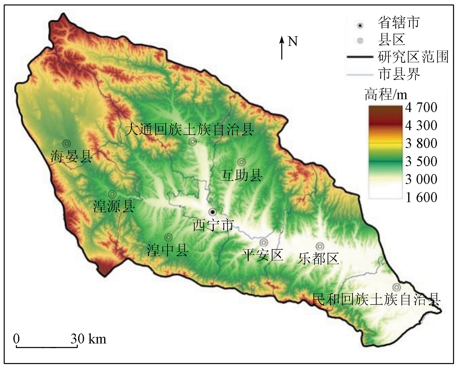
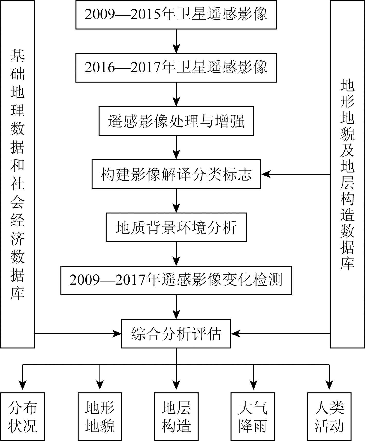
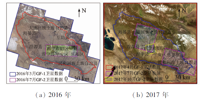
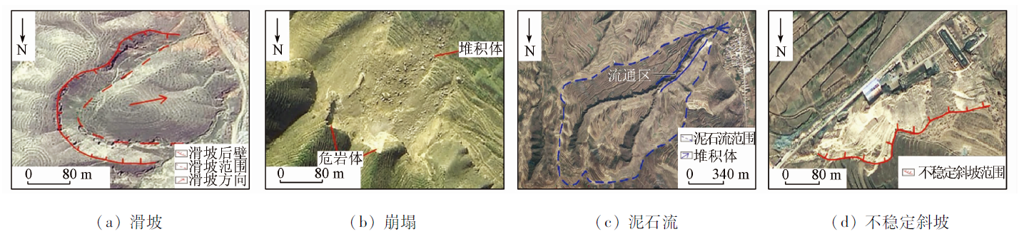
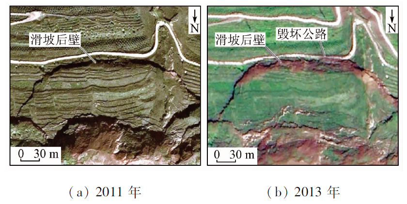
Abstract This study investigated the causes of the frequent occurrence of geologic hazards in the Huangshui River basin of Qinghai Province in recent years mainly using the GF-1 and GF-2 satellite remote sensing data. Based on the comparative monitoring of multi-source, multi-temporal, and multi-period remote sensing images and the support of geoscience knowledge, this study built a detailed and reliable spatial distribution database of geological hazards through the sorting, analysis, and screening of existent geologic hazard data of the study area, the laboratory interpretation of remote sensing images, and field investigation and verification. Then, it conducted a statistical analysis using the spatial analysis module of GIS and the parameters of geologic hazards. Finally, this study explored the relationships between the occurrence of geologic hazards and geological environment, natural factors, and human activities. The results are as follows. In 2017, 3 188 sites of geologic hazards such as collapse and landslide were discovered in the study area. A total of 233 geologic hazard sites have changed since 2009. Among the formation conditions of geologic hazards, the geological environment conditions have changed slowly, while human engineering activities and rainfall have been the most active factors, which jointly induced geologic hazards.
|
| Keywords
geological disasters
Huangshui River basin
dynamic change
remote sensing monitoring
change analysis
|
|
|
|
Issue Date: 27 December 2022
|
|
|
| [1] |
刘峰, 陈惠娟, 王士东, 等. 西宁市主要地质灾害成因及变形破坏模式分析[J]. 地下水, 2015, 37(3):175-177.
|
| [1] |
Liu F, Chen H J, Wang S D, et al. Analysis on main geological disasters formation causes and deformation failure mode in Xining[J]. Ground Water, 2015, 37(3):175-177.
doi: 10.1111/j.1745-6584.1999.tb00972.x
url: https://onlinelibrary.wiley.com/doi/10.1111/j.1745-6584.1999.tb00972.x
|
| [2] |
李宏杰, 戴福初, 许领, 等. 地质灾害调查中 ETM+与SPOT 5 Pan影像融合与评价[J]. 国土资源遥感, 2008, 20(1):43-45,54.doi:10.6046/gtzyyg.2008.01.09.
doi: 10.6046/gtzyyg.2008.01.09
|
| [2] |
Li H J, Dai F C, Xu L, et al. The assessment of fused image of ETM+ and SPOT 5 Pan in the investigation of geological hazards[J]. Remote Sensing for Land and Resources, 2008, 20(1):43-45,54.doi:10.6046/gtzyyg.2008.01.09.
doi: 10.6046/gtzyyg.2008.01.09
|
| [3] |
曾磊, 黄玉华. 黄土高原河谷演变与地质灾害发育规律研究——以陕西省子长县为例[J]. 中国地质灾害与防治学报, 2010, 21(3):67-72.
|
| [3] |
Zeng L, Huang Y H. Valley evolution and geologic hazard occurrences in the Loess Plateau of China:A case study:Zichang County in the northern Loess Plateau of Shaanxi Province[J]. The Chinese Journal of Geological Hazard and Control, 2010, 21(3):67-72.
|
| [4] |
朱静, 唐川. 遥感技术在我国滑坡研究中的应用综述[J]. 遥感技术与应用, 2012, 27(3):458-464.
|
| [4] |
Zhu J, Tang C. An overview of remote sensing applications for landslide research in China[J]. Remote Sensing Technology and Application, 2012, 27(3):458-464.
|
| [5] |
范敏, 孙小飞, 苏凤环, 等. 国产高分卫星数据在西南山区地质灾害动态监测中的应用[J]. 国土资源遥感, 2017, 29(s1):85-89.doi:10.6046/gtzyyg.2017.s1.14.
doi: 10.6046/gtzyyg.2017.s1.14
|
| [5] |
Fan M, Sun X F, Su F H, et al. Application analysis of remote sensing dynamic monitoring for geological hazards in southwest mountainous areas using domestic high resolution satellite data[J]. Remote Sensing for Land and Resources, 2017, 29(s1):85-89.doi:10.6046/gtzyyg.2017.s1.14.
doi: 10.6046/gtzyyg.2017.s1.14
|
| [6] |
刘肖姬, 梁树能, 吴小娟, 等. “高分二号”卫星数据遥感滑坡灾害识别研究——以云南东川为例[J]. 航天返回与遥感, 2015, 36(4):93-100.
|
| [6] |
Liu X J, Liang S N, Wu X J, et al. Interpretation of landslide in Dongchuan District of Yunnan Province using GF-2 satellite data[J]. Spacecraft Recovery and Remote Sensing, 2015, 36(4):93-100.
|
| [7] |
张焜, 李晓民, 马世斌, 等. GF-1图像在中印边境楚鲁松杰村地质灾害调查中的应用[J]. 国土资源遥感, 2016, 28(2):139-148.doi:10.6046/gtzyyg.2016.02.22.
doi: 10.6046/gtzyyg.2016.02.22
|
| [7] |
Zhang K, Li X M, Ma S B, et al. Application of GF-1 image to geo-logical disaster survey in Cosibsumgy village on Sino-India border area[J]. Remote Sensing for Land and Resources, 2016, 28(2):139-148.doi:10.6046/gtzyyg.2016.02.22.
doi: 10.6046/gtzyyg.2016.02.22
|
| [8] |
郑雄伟, 杨金中, 陈玲, 等. 国土资源卫星地质矿产应用成效[J]. 国土资源遥感, 2017, 29(s1):1-7.doi:10.6046/gtzyyg.2017.s1.01.
doi: 10.6046/gtzyyg.2017.s1.01
|
| [8] |
Zheng X W, Yang J Z, Chen L, et al. A review on the effects of applying land and resources satellites to geology and mineral resources[J]. Remote Sensing for Land and Resources, 2017, 29(s1):1-7.doi:10.6046/gtzyyg.2017.s1.01.
doi: 10.6046/gtzyyg.2017.s1.01
|
| [9] |
刘小玉. “基于国产卫星的地质灾害调查系统”在黄土滑坡区的示范应用研究[J]. 西北地质, 2017, 50(2):250-258.
|
| [9] |
Liu X Y. “The geological hazard investigation system based on domestic satellite”:Demonstration and application in the loess landslide area[J]. Northwestern Geology, 2017, 50(2):250-258.
|
| [10] |
张雪峰, 何政伟, 薛东剑, 等. 汶川地震大型单体滑坡遥感调查与危险性评价[J]. 遥感信息, 2011(3):50-54.
|
| [10] |
Zhang X F, He Z W, Xue D J, et al. Remote sensing investigation and risk assessment of large scale individual landslide triggered by the Wenchuan earthquake[J]. Remote Sensing Information, 2011(3):50-54.
|
| [11] |
张路路, 刘召芹, 刘峰, 等. 基于数字高程模型的古滑坡区提取[J]. 遥感信息, 2015, 30(6):37-41.
|
| [11] |
Zhang L L, Liu Z Q, Liu F, et al. Extraction of ancient landslide based on DEM[J]. Remote Sensing Information, 2015, 30(6):37-41.
|
| [12] |
贾伟洁, 王治华. 基于高分辨率遥感影像的滑坡活动特征及稳定性分析——以东苗家滑坡为例[J]. 国土资源遥感, 2019, 30(6):174-181.doi:10.6046/gtzyyg.2019.04.23.
doi: 10.6046/gtzyyg.2019.04.23
|
| [12] |
Jia W J, Wang Z H. Activity characteristics and stability analysis based on high-resolution remote sensing image:A case study of Dongmiaojia landslide[J]. Remote Sensing for Land and Resources, 2019, 30(6):174-181.doi:10.6046/gtzyyg.2019.04.23.
doi: 10.6046/gtzyyg.2019.04.23
|
| [13] |
童立强, 郭兆成. 典型滑坡遥感影像特征研究[J]. 国土资源遥感, 2013, 25(1):86-92.doi:10.6046/gtzyyg.2013.01.16.
doi: 10.6046/gtzyyg.2013.01.16
|
| [13] |
Tong L Q, Guo Z C. Remote sensing image features of typical landslides[J]. Remote Sensing for Land and Resources, 2013, 25(1):86-92.doi:10.6046/gtzyyg.2013.01.16.
doi: 10.6046/gtzyyg.2013.01.16
|
| [14] |
刘志中, 宋英旭, 叶润青. 渝东北2014年“8·31”暴雨诱发滑坡遥感解译与分析[J]. 自然资源遥感, 2021, 33(4):192-199.doi:10.6046/zrzyyg.2020348.
doi: 10.6046/zrzyyg.2020348
|
| [14] |
Liu Z Z, Song Y X, Ye R Q. An analysis of rainstorm-induced landslide in northeast Chongqing on August 31,2014 based on interpretation of remote sensing images[J]. Remote Sensing for Natural Resources, 2021, 33(4):192-199.doi:10.6046/zrzyyg.2020348.
doi: 10.6046/zrzyyg.2020348
|
| [15] |
郭兆成, 聂洪峰, 杨亮, 等. 鹤庆盆地东缘古滑坡遥感识别与特征研究[J]. 现代地质, 2014, 28(5):1068-1076.
|
| [15] |
Guo Z C, Nie H F, Yang L, et al. Ancient landslide identification and characteristics using remote sensing along eastern edge of the Heqing basin[J]. Geoscience, 2014, 28(5):1068-1076.
|
| [16] |
邱海军, 胡胜, 崔鹏, 等. 黄土滑坡灾害空间格局及其空间尺度依赖性研究[J]. 第四纪研究, 2017, 37(2):307-318.
|
| [16] |
Qiu H J, Hu S, Cui P, et al. Pattern analysis of loess landslides and their scale dependency[J]. Quaternary Sciences, 2017, 37(2):307-318.
|
| [17] |
杨玲, 权开兄, 代庆礼, 等. 西宁市重大地质灾害隐患分布规律研究[J]. 青海环境, 2015, 25(3):113-121.
|
| [17] |
Yang L, Quan K X, Dai Q L, et al. Study on the distribution law of major geological hazards in Xining City[J]. Environment of Qinghai, 2015, 25(3):113-121.
|
| [18] |
邓中林, 侯元才, 古凤宝, 等. 青海东北部第三纪西宁—贵德—化隆盆地充填特征、抱粉组合方式与古气候变化[J]. 青海地质, 2000, 9(1):43-53.
|
| [18] |
Deng Z L, Hou Y C, Gu F B, et al. Filling characteristics,sporopolen assemblage and palaeoclimate variation of tertiary basins in the northeastern Qinghai-Tibet Plateau[J]. Qinghai Geological, 2000, 9(1):43-53.
|
| [19] |
魏林森, 丁宏伟, 王婷, 等. 降水对陇西黄土滑坡的诱发作用及时空影响分析[J]. 冰川冻土, 2017, 39(3):609-615.
|
| [19] |
Wei L S, Ding H W, Wang T, et al. Loess landslide in Longxi of Gansu Province:Precipitation inducted function and space-time effect[J]. Journal of Glaciology and Geocryology, 2017, 39(3):609-615.
|
| [20] |
朱立峰, 谷天峰, 胡炜, 等. 灌溉诱发黄土滑坡的发育机制研究[J]. 工程地质学报, 2016, 24(4):485-491.
|
| [20] |
Zhu L F, Gu T F, Hu W, et al. Developmental mechanism of irrigation-induced loess landslides[J]. Journal of Engineering Geology, 2016, 24(4):485-491.
|
| [21] |
彭建兵, 吴迪, 段钊, 等. 典型人类工程活动诱发黄土滑坡灾害特征与致灾机理[J]. 西南交通大学学报, 2016, 51(5):971-980.
|
| [21] |
Peng J B, Wu D, Duan Z, et al. Disaster characteristics and destructive mechanism of typical loess landslide cases triggered by human engineering activities[J]. Journal of Southwest Jiaotong Univercity, 2016, 51(5):971-980.
|
| [22] |
吴玮江, 叶伟林, 姚正学, 等. 甘肃永靖黑方台4·29罗家坡黄土滑坡的特征[J]. 冰川冻土, 2016, 38(3):662- 670.
|
| [22] |
Wu W J, Ye W L, Yao Z X, et al. Characteristics of the Luojiapo loess landslides at Heifangtai,burst on April 29,2015,in Yongjing County,Gansu Province[J]. Journal of Glaciology and Geocryology, 2016, 38(3):662-670.
|
| [23] |
刘传正. 城镇建设中的地质环境科学利用问题[J]. 水文地质工程地质, 2015, 42(4):1-7.
|
| [23] |
Liu C Z. Some problems of land use in urbanization of mountainous area[J]. Hydrogeology and Engineering Geology, 2015, 42(4):1-7.
|
| [24] |
李智敏, 张进, 田勤俭, 等. 西宁湟水河隐伏断裂发育模式探讨[J]. 中国地质, 2009, 36(6):1245-1250.
|
| [24] |
Li Z M, Zhang J, Tian Q J, et al. A discussion on the development model of the concealed fault along the Huangshui River in Xining[J]. Geology in China, 2009, 36(6):1245-1250.
|
|
Viewed |
|
|
|
Full text
|
|
|
|
|
Abstract
|
|
|
|
|
Cited |
|
|
|
|
| |
Shared |
|
|
|
|
| |
Discussed |
|
|
|
|
 2022,
Vol. 34
2022,
Vol. 34