|
|
|
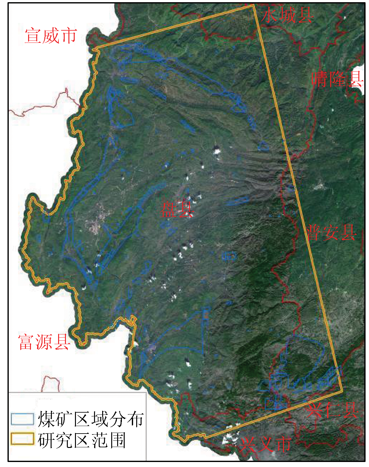
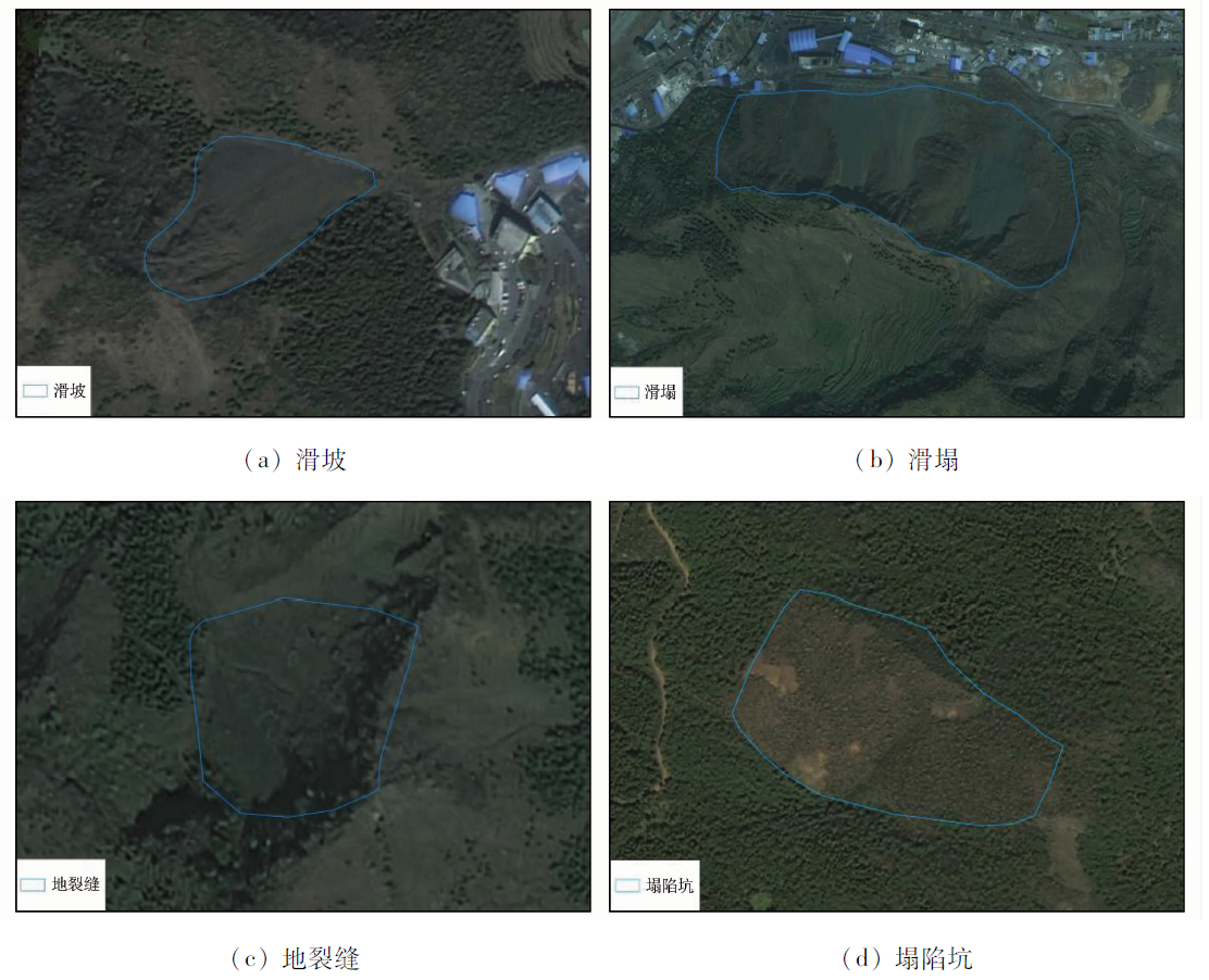
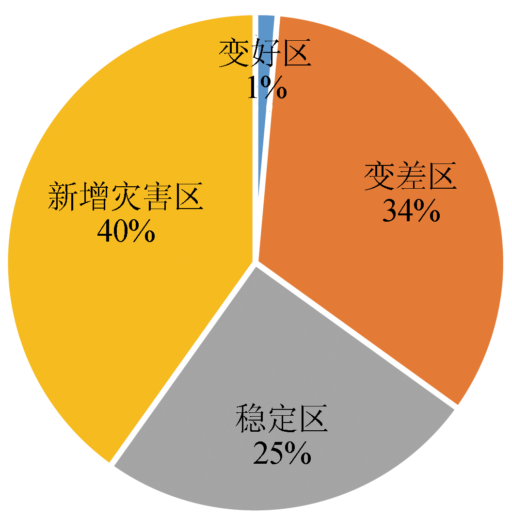
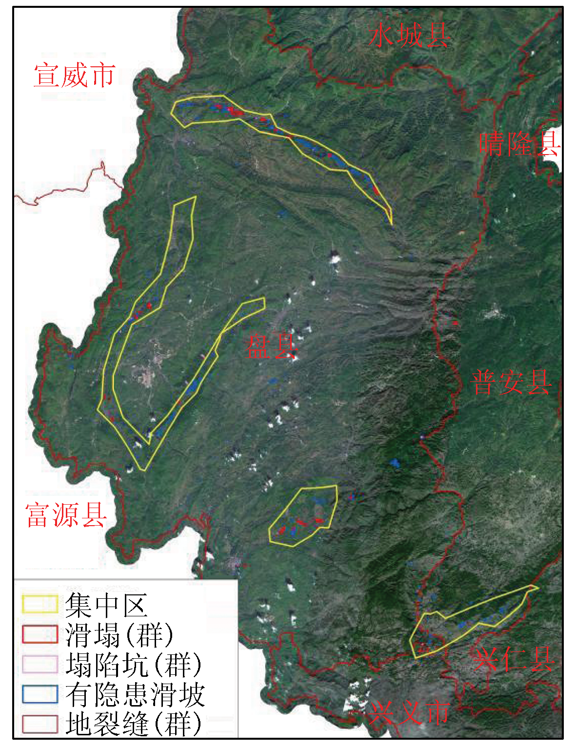
Abstract Southwestern China suffers frequent geological disasters. The exploitation of mineral resources in southwestern China is highly liable to induce geological disasters and related secondary disasters. This study investigated the remote sensing-based dynamic monitoring technology for coal mine collapse areas in the coal mining concentration areas in Liupanshui City, Guizhou Province. Based on the high-resolution remote sensing images, this study established remote sensing geological interpretation symbols of coal mine collapse areas in the mountainous plateau of southwestern Guizhou and then dynamically monitored the geological disasters in Liupanshui from 2009 to 2018. Moreover, this study analyzed the present geological disasters in the study area. The remote sensing interpretation revealed that geological disasters in the study area were significantly aggravated over the years. Compared with 2009, 2018 witnessed an increase of 167% in the geological disasters, including 40% of new geological disaster areas and 34% of areas with deteriorated geological disasters. According to the geological disaster degrees in the study area, this study identified four geological disaster concentration areas, which were highly consistent with the mining concentration areas in the study area. Based on the remote sensing data, this study analyzed the types of land damaged by geological disasters in mines and investigated possible resulting damage to the people and the ecological environment in the study area. The results show that disasters that severely damaged land caused the largest damage area for forest and cultivated lands, which had a total number of 193 and a total area of about 333.55 hm2. There are 360 areas with potential hazards in the study area, covering an area of 506.36 hm2. They are dominated by 126 threats to roads, which cover an area of 110.04 hm2. The results of this study can provide a reliable data reference and a critical research approach for restoring the local ecological environment and controlling geological disasters in mines. Moreover, based on the characteristics of the study area, this study further analyzed the causes of the geological disasters in mines, explored the geological disaster control schemes, and proposed countermeasures and suggestions.
|
| Keywords
Liupanshui City
geological disasters in mines
remote sensing monitoring
coal mine collapse area
|
|
|
|
Issue Date: 19 September 2023
|
|
|
| [1] |
国土资源部. DZ/T0223—2011矿山地质环境保护与恢复治理方案编制规范[S]. 北京: 国土资源部地质环境司, 2011.
|
| [1] |
Ministry of Land and Resources. DZ/T0223—2011 mine geological environmental protection and restoration and control plan preparation specifications[S]. Beijing: Department of Geology and Environment,Ministry of Land and Resources, 2011.
|
| [2] |
高俊华, 刘莎莎, 杨金中, 等. 基于遥感的露天煤矿集中区地质环境灰关联评价——以准格尔煤田为例[J]. 国土资源遥感, 2021, 33(3):183-190.doi:10.6046/gtzyyg.2020006.
doi: 10.6046/gtzyyg.2020006
|
| [2] |
Gao J H, Liu S S, Yang J Z, et al. Gray correlation evaluation of geo-logical environment in the open-pit coal mine concentration area based on remote sensing:A case study of the Zhungeer Coalfield[J]. Remote Sensing for Land and Resources, 2021, 33(3):183-190.doi:10.6046/gtzyyg.2020006.
doi: 10.6046/gtzyyg.2020006
|
| [3] |
王晓红, 荆青青, 周英杰, 等. 山东省采煤沉陷遥感动态监测[J]. 国土资源遥感, 2017, 29(3):203-210.doi:10.6046/gtzyyg.2017.03.30.
doi: 10.6046/gtzyyg.2017.03.30
|
| [3] |
Wang X H, Jing Q Q, Zhou Y J, et al. Remote sensing dynamic monitoring of coal mine subsidence disaster in Shandong Province[J]. Remote Sensing for Land and Resources, 2017, 29(3):203-210.doi:10.6046/gtzyyg.2017.03.30.
doi: 10.6046/gtzyyg.2017.03.30
|
| [4] |
牛威. 煤矿采空塌陷导致土地破坏状况及危害[J]. 华北国土资源, 2007(1):49-50,55.
|
| [4] |
Niu W. Land destruction and damage caused by coal mining collapse[J]. Huabei Land and Resources, 2007(1) :49-50,55.
|
| [5] |
高清武, 牛景才. 煤田采空沉陷及其影响因素分析[J]. 中国地质灾害与防治学报, 1997, 8(3):57-61.
|
| [5] |
Gao Q W, Niu J C. The coalfield exploitation subsidence and analyses on its effective factors[J]. The Chinese Journal of Geological Hazard and Control, 1997, 8(3):57-61.
|
| [6] |
李成尊, 聂洪峰, 汪劲, 等. 矿山地质灾害特征遥感研究[J]. 国土资源遥感, 2005, 17(1):45-48,78.doi:10.6046/gtzyyg.2005.01.11.
doi: 10.6046/gtzyyg.2005.01.11
|
| [6] |
Li C Z, Nie H F, Wang J, et al. Remote sensing study on mine geological disaster characteristics[J]. Remote Sensing for Land and Resources, 2005, 17(1):45-48,78.doi:10.6046/gtzyyg.2005.01.11.
doi: 10.6046/gtzyyg.2005.01.11
|
| [7] |
杜培军, 陈云浩, 曹金亮, 等. 煤矿区地质环境与地质灾害遥感集成监测系统的关键技术[J]. 地理信息世界, 2008, 10(5):14-20.
|
| [7] |
Du P J, Chen Y H, Cao J L, et al. The key technology of remote sensing integrated monitoring system of geological environment and geological disaster in coal mine area[J]. Geomatics World, 2008, 10(5):14-20.
|
| [8] |
徐刚, 郑达兴, 李述靖, 等. 黄土高原西南部陇县一千阳一带崩塌、滑坡地质灾害的遥感影像特征及分布规律[J]. 地质通报, 2008, 27(11):1837-1845.
|
| [8] |
Xu G, Zheng D X, Li S J, et al. Remote sensing images and distribution characteristics of avalanche and landslide geohazards in the western part of the Weibei Plateau,Shaanxi Province,China[J]. Geological Bulletin of China, 2008, 27(11):1837-1845.
|
| [9] |
冯雨林, 陈江, 姜琦刚, 等. 3D遥感影像模型在古乡沟泥石流地质灾害预警中的应用[J]. 地质灾害与环境保护, 2009, 20(3):114-119.
|
| [9] |
Feng Y L, Chen J, Jing Q G, et al. The application of 3D remote sensing image model of debris flow disaster warning in Gu-xiang gully,Tibet[J]. Journal of Geological Hazards and Environment Preservation, 2009, 20(3):114-119.
|
| [10] |
宁树正, 万余庆, 孙顺新. 煤矿区沉降与遥感监测方法探讨[J]. 中国煤炭地质, 2008, 20(1):10-12.
|
| [10] |
Ning S Z, Wang Y Q, Sun S X. A discussion of coal mining area subsidence and remote sensing monitoring[J]. Coal Geology of China, 2008, 20(1):10-12.
|
| [11] |
濮国梁, 杨武年, 刘汉超. 正射遥感影像地图制作技术在岷江上游滑坡研究中的应用[J]. 成都理工学院学报, 2000, 27(3):312-317.
|
| [11] |
Pu G L, Yang W N, Liu H C. Applications of orthophoto map of landsat TM to the study of cracks and landslides on upper reaches of the Minjiang River[J]. Journal of Chengdu University of Technology, 2000, 27(3):312-317.
|
| [12] |
顾广明, 王丽, 蒋德林, 等. 3S技术在煤矿区开发现状及环境监测中的应用[J]. 煤田地质与勘探, 2006, 34(5):51-55.
|
| [12] |
Gu G M, Wang L, Jiang D L, et al. Application of 3S technology to monitoring development and environment conditions in coal mine area[J]. Coal Geology and Exploration, 2006, 34(5):51-55.
|
| [13] |
尚红英, 陈建平, 李成尊, 等. RS在矿山动态监测中的应用——以新疆稀有金属矿集区为例[J]. 遥感技术与应用, 2008, 23(2):189-195.
|
| [13] |
Shang H Y, Chen J P, Li C Z, et al. Application of remote sensing in the dynamic inspection of the mining:An example in the rare metal ore concentration area of Xinjiang[J]. Remote Sensing Technology and Application, 2008, 23(2):189-195.
|
| [14] |
乔彦肖, 李密文, 张维宸. 基于遥感技术支持的地质灾害及孕灾环境综合评价[J]. 中国地质灾害与防治学报, 2002, 13(4):83-87.
|
| [14] |
Qiao Y X, Li M W, Zhang W C. Comprehensive evaluation on geological hazards and the environment of developing geological hazards in the northwest Hebei on the basis of RS[J]. The Chinese Journal of Geological Hazard and Control, 2002, 13(4):83-87.
|
| [15] |
王钦军, 陈玉, 蔺启忠, 等. 矿山地质灾害遥感监测方法及成因分析——以北京房山区史家营煤矿为例[J]. 中国地质灾害与防治学报, 2011, 22(1):75-79.
|
| [15] |
Wang Q J, Chen Y, Lin Q Z, et al. Remote sensing monitoring method and cause analysis of mine geological disaster:Take Shijiaying coal mine in Fangshan District,Beijing as an example[J]. The Chinese Journal of Geological Hazard and Control, 2011, 22(1):75-79.
|
| [16] |
何国清, 杨伦, 凌赓娣, 等. 矿山开采沉陷学[M]. 徐州: 中国矿业大学出版社,1991.
|
| [16] |
He G Q, Yang L, Ling G D, et al. Mining subsidence theory[M]. Xuzhou: China University of Mining and Technology Publisher,1991.
|
| [17] |
沙永莲, 王晓文, 刘国祥, 等. 基于SBAS InSAR的新疆哈密砂墩子煤田开采沉陷监测与反演[J]. 自然资源遥感, 2021, 33(3):194-201.doi:10.6046/zrzyyg.2020026.
doi: 10.6046/zrzyyg.2020026
|
| [17] |
Sha Y L, Wang X W, Liu G X, et al. SBAS-In SAR-based monitoring and inversion of surface subsidence of the Shadunzi coal mine in Hami City,Xinjiang[J]. Remote Sensing for Natural Resources, 2021, 33(3):194-201.doi:10.6046/zrzyyg.2020026.
doi: 10.6046/zrzyyg.2020026
|
| [18] |
桑潇, 张成业, 李军, 等. 煤炭开采背景下的伊金霍洛旗土地利用变化强度分析[J]. 自然资源遥感, 2021, 33(3):148-155.doi:10.6046/zrzyyg.2020358.
doi: 10.6046/zrzyyg.2020358
|
| [18] |
Sang X, Zhang C Y, Li J, et al. Application of intensity analysis theory in the land use change in Yijin Holo Banner under the background of coal mining[J]. Remote Sensing for Natural Resources, 2021, 33(3):148-155.doi:10.6046/zrzyyg.2020358.
doi: 10.6046/zrzyyg.2020358
|
| [19] |
杨显华, 黄洁, 田立, 等. 矿山遥感监测在采空区稳定性分析中的应用[J]. 国土资源遥感, 2018, 30(3):143-150.doi:10.6046/gtzyyg.2018.03.20.
doi: 10.6046/gtzyyg.2018.03.20
|
| [19] |
Yang X H, Huang J, Tian L, et al. Application of mine remote sensing monitoring to analysis of mine goaf stability[J]. Remote Sensing for Land and Resources, 2018, 30(3):143-150.doi:10.6046/gtzyyg.2018.03.20.
doi: 10.6046/gtzyyg.2018.03.20
|
| [20] |
易同生, 高为. 六盘水煤田上二叠统煤系气成藏特征及共探共采方向[J]. 煤炭学报, 2018, 43(6):1553-1564.
|
| [20] |
Yi T S, Gao W. Reservoir formation characteristics as well as co-exploration and co-mining orientation of Upper Permian coal-bearing gas in Liupanshui coalfield[J]. Journal of China Coal Society, 2018, 43(6):1553-1564.
|
| [21] |
吴财芳, 刘小磊, 张莎莎. 滇东黔西多煤层地区煤层气“层次递阶”地质选区指标体系构建[J]. 煤炭学报, 2018, 43(6):1647-1653.
|
| [21] |
Wu C F, Liu X L, Zhang S S. Construction of “hierarchical” geological selection index system for coalbed methane in multi coal seam areas of eastern Yunnan and western Guizhou[J]. Journal of China Coal Society, 2018, 43(6):1647-1653.
|
| [22] |
高为, 田维江, 秦文, 等. 贵州省煤层气与页岩气共探共采的地质优选[J]. 断块油气田, 2014, 21(1):36-38.
|
| [22] |
Gao W, Tian W J, Qin W, et al. Geological optimization of coalbed methane and shale gas co-exploration and concurrent production in Guizhou Province[J]. Fault-Block Oil and Gas Field, 2014, 21(1):36-38.
|
| [23] |
迟焕鹏, 毕彩芹, 单衍胜, 等. 黔西都格井田煤层气储层特征及可采性[J]. 煤炭学报, 2018, 43(12):3447-3452.
|
| [23] |
Chi H P, Bi C Q, Shan Y S, et al. Reservoir characteristics and recoverability of CBM resource in Duge coalfield of western Guizhou[J]. Journal of China Coal Society, 2018, 43(12):3447-3452.
|
| [24] |
高为, 易同生, 金军, 等. 黔西地区煤样孔隙综合分形特征及对孔渗性的影响[J]. 煤炭学报, 2017, 42(5):1258-1265.
|
| [24] |
Gao W, Yi T S, Jin J, et al. Pore integrated fractal characteristics of coal sample in western Guizhou and its impact to porosity and permeability[J]. Journal of China Coal Society, 2017, 42(5):1258-1265.
|
| [25] |
高为, 易同生. 黔西松河井田煤储层孔隙特征及对渗透性的影响[J]. 煤炭科学技术, 2016, 44(2):55-61.
|
| [25] |
Gao W, Yi T S. Pore features of coal reservoir in Song-he mine field of west Guizhou and its impact to permeability[J]. Coal Science and Echnology, 2016, 44(2):55-61.
|
| [26] |
高为, 韩忠勤, 吕放, 等. 六盘水地区煤层含气性地质特征及差异成因[J]. 煤炭科学技术, 2022, 50(11):122-130.
|
| [26] |
Gao W, Han Z Q, Lyu F, et al. Geological characteristics of gas in coal seam and cause of difference in Liupanshui area[J]. Coal Science and Technology, 2022, 50(11):122-130.
|
| [27] |
陈玲, 贾佳, 王海庆. 高分遥感在自然资源调查中的应用综述[J]. 国土资源遥感, 2019, 31(1):1-7.doi:10.6046/gtzyyg.2019.01.01.
doi: 10.6046/gtzyyg.2019.01.01
|
| [27] |
Chen L, Jia J, Wang H Q. An overview of applying high resolution remote sensing to land and resources survey[J]. Remote Sensing for Land and Resources, 2019, 31(1):1-7.doi:10.6046/gtzyyg.2019.01.01.
doi: 10.6046/gtzyyg.2019.01.01
|
| [28] |
郑雄伟, 彭孛, 尚坤. 基于国产卫星的遥感地质解译能力评估[J]. 自然资源遥感, 2021, 33(3):1-10.doi:10.6046/zrzyyg.2020357.
doi: 10.6046/zrzyyg.2020357
|
| [28] |
Zheng X W, Peng B, Shang K. Assessment of the interpretation ability of domestic satellites in geological remote sensing[J]. Remote Sensing for Natural Resources, 2021, 33(3):1-10.doi:10.6046/zrzyyg.2020357.
doi: 10.6046/zrzyyg.2020357
|
| [29] |
中国地质调查局. 滑坡崩塌泥石流灾害调查规范(1∶50 000):DD2008-02[S]. 北京: 中国地质调查局, 2008:9-15.
|
| [29] |
China Geological Survey. Code for investigation of landslide,collapse and debris flow disasters(1∶50 000):DD2008-02[S]. Beijing: China Geological Survey, 2008:9-15.
|
| [30] |
童立强, 郭兆成. 典型滑坡遥感影像特征研究[J]. 国土资源遥感, 2013, 25(1):86-92.doi:10.6046/gtzyyg.2013.01.16.
doi: 10.6046/gtzyyg.2013.01.16
|
| [30] |
Tong L Q, Guo Z C. Study on remote sensing image characteristics of typical landslide[J]. Remote Sensing for Land and Resources, 2013, 25(1):86-92.doi:10.6046/gtzyyg.2013.01.16.
doi: 10.6046/gtzyyg.2013.01.16
|
| [31] |
张志军, 李有三, 祁万强, 等. 基于GF-2数据的G314沿线奥—塔段地质灾害遥感调查[J]. 合肥工业大学学报(自然科学版), 2021, 44(9):1249-1257.
|
| [31] |
Zhang Z J, Li Y S, Qi W Q, et al. Investigation and evaluation of geological hazards using GF-2 remote sensing technology in Aoyitage-Taheman section of highway G314[J]. Journal of Hefei University of Technology(Natural Science), 2021, 44(9):1249-1257.
|
| [32] |
王庆雅, 张锦. 高分辨率遥感影像滑坡纹理特征提取方法[J]. 太原理工大学学报, 2021, 52(4):547-556.
|
| [32] |
Wang Q Y, Zhang J. Landslide texture feature extraction method from high resolution remote sensing images[J]. Journal of Taiyuan University of Technology, 2021, 52(4):547-556.
|
| [33] |
王晓文, 刘巧, 张波, 等. 近40 a昆仑山口37号冰川冰舌滑塌多源遥感监测与分析[J]. 武汉大学学报(信息科学版), 2020, 45(11):1687-1696.
|
| [33] |
Wang X W, Liu Q, Zhang B, et al. Multi-source remote sensing monitoring and analysis of glacier tongue slide in Kunlun Mountain Pass in recent 40 years[J]. Geomatics and Information Science of Wuhan University, 2020, 45(11):1687-1696.
|
| [34] |
侯恩科, 张杰, 谢晓深, 等. 无人机遥感与卫星遥感在采煤地表裂缝识别中的对比[J]. 地质通报, 2019, 38(s1):261-266.
|
| [34] |
Hou E K, Zhang J, Xie X S, et al. Comparison of UAV remote sensing and satellite remote sensing in coal mining surface crack identification[J]. Geological Bulletin of China, 2019, 38(s1):261-266.
|
| [35] |
王娅娟, 孟淑英, 李军, 等. 地裂缝信息遥感提取方法研究[J]. 神华科技, 2011(5):31-33,39.
|
| [35] |
Wang Y J, Meng S Y, Li J, et al. Research on remote sensing extraction method of ground fracture information[J]. Shenhua Technology, 2011(5):31-33,39.
|
| [36] |
魏长婧, 汪云甲, 王坚, 等. 无人机影像提取矿区地裂缝信息技术研究[J]. 金属矿山, 2012, 41(10):90-92.
|
| [36] |
Wei C J, Wang Y J, Wang J, et al. Research on information technology of ground fracture extraction from mining area by UAV image[J]. Metal Mine, 2012, 41(10):90-92.
|
| [37] |
韦博文, 刘国祥, 汪致恒. 基于改进的MF-FDOG算法和无人机影像提取黄土地区地裂缝[J]. 测绘, 2018, 41(2):51-56,61.
|
| [37] |
Wei B W, Liu G X, Wang Z H. Based on improved MF-FDOG algorithm and UAV image extraction of ground fractures in loess region[J]. Surveying and Mapping, 2018, 41(2):51-56,61.
|
| [38] |
张兴航, 朱琳, 王威, 等. 基于对象的地裂缝分步提取方法研究与应用[J]. 国土资源遥感, 2019, 31(1):87-94.doi:10.6046/gtzyyg.2019.01.12.
doi: 10.6046/gtzyyg.2019.01.12
|
| [38] |
Zhang X H, Zhu L, Wang W, et al. Research and application of object-based step extraction method for ground fracture[J]. Remote Sensing for Land and Resources, 2019, 31(1):87-94.doi:10.6046/gtzyyg.2019.01.12.
doi: 10.6046/gtzyyg.2019.01.12
|
| [39] |
杨豪杰, 张锦. 矿区采动地裂缝高分辨率影像特征分析[J]. 地理信息世界, 2020, 27(6):57-63.
|
| [39] |
Yang H J, Zhang J. Analysis of high resolution image characteristics of mining ground fracture[J]. Geomatics World, 2020, 27(6):57-63.
|
| [40] |
张敦虎, 卢中正, 强建华, 等. 地面塌陷特征及其遥感识别方法研究[J]. 地质灾害与环境保护, 2009, 20(3):8-12.
|
| [40] |
Zhang D H, Lu Z Z, Qiang J H, et al. Study on the characteristics of ground collapse and its remote sensing recognition method[J]. Journal of Geological Hazards and Environment Preservation, 2009, 20(3):8-12.
|
| [41] |
杨圣军, 赵燕, 吴泉源, 等. 高分辨率遥感图像中采矿塌陷地的提取——以龙口矿区为例[J]. 地域研究与开发, 2006, 25(4):120-124.
|
| [41] |
Yang S J, Zhao Y, Wu Q Y, et al. Mining subsidence extraction from high resolution remote sensing images:Take Longkou mining area as an example[J]. Areal Research and Development, 2006, 25(4):120-124.
|
| [42] |
孙超. 地下采空区对地表稳定性的影响[D]. 哈尔滨: 中国地震局工程力学研究所, 2005.
|
| [42] |
Sun C. Influence of underground goaf on surface stability[D]. Harbin: Institute of Engineering Mechanics,China Seismological Bureau, 2005.
|
| [43] |
黎来福, 王秀丽. SPOT-5卫星遥感数据在煤矿塌陷区监测中的应用[J]. 矿山测量, 2008(2):45-47.
|
| [43] |
Li L F, Wang X L. Application of SPOT-5 satellite remote sensing data in coal mine subsidence area monitoring[J]. Mine Surveying, 2008(2):45-47.
|
| [44] |
许长辉, 高井祥, 王坚, 等. 多源多时相遥感数据融合在煤矿塌陷地中应用研究[J]. 水土保持研究, 2008, 15(1):92-96.
|
| [44] |
Xu C H, Gao J X, Wang J, et al. Application research of multi-source multi-temporal remote sensing data fusion in coal mine subsidence[J]. Research of Soil and Water Conservation, 2008, 15(1):92-96.
|
| [45] |
杜培军, 郭达志. GIS支持下遥感图像中采矿塌陷地提取方法研究[J]. 中国图象图形学报, 2003, 8(2):231-235.
|
| [45] |
Du P J, Guo D Z. Research on mining subsidence extraction method from remote sensing image supported by GIS[J]. Journal of Image and Graphics, 2003, 8(2):231-235.
|
| [46] |
余学义, 施文刚. 地表剩余沉陷的预计方法[J]. 西安矿业学院学报, 1996(1):1-4,27.
|
| [46] |
Yu X Y, Shi W G. Methods for predicting residual surface subsidence[J]. Journal of Xi’an University of Science and Technology, 1996(1):1-4,27.
|
| [47] |
赵玉灵. 基于层次分析法的矿山环境评价方法研究——以海南岛为例[J]. 国土资源遥感, 2020, 32(1):148-153.doi:10.6046/gtzyyg.2020.01.20.
doi: 10.6046/gtzyyg.2020.01.20
|
| [47] |
Zhao Y L. Study and application of analytic hierarchy process of mine geological environment:A case study in Hainan Island[J]. Remote Sensing for Land and Resources, 2020, 32(1):148-153.doi:10.6046/gtzyyg.2020.01.20.
doi: 10.6046/gtzyyg.2020.01.20
|
|
Viewed |
|
|
|
Full text
|
|
|
|
|
Abstract
|
|
|
|
|
Cited |
|
|
|
|
| |
Shared |
|
|
|
|
| |
Discussed |
|
|
|
|
 2023,
Vol. 35
2023,
Vol. 35
 ), AN Na(