|
|
 |
|

|
|
|
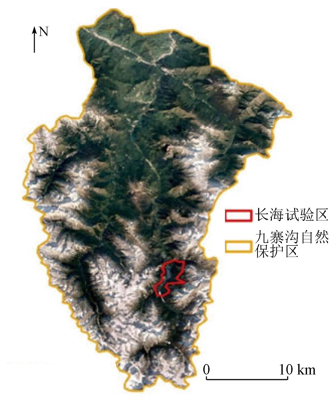
Fine-scale remote sensing monitoring and interpretation of large-scene vegetation health in the Jiuzhai Valley biosphere reserve: A case study of the Changhai pilot zone |
GAO Sheng1,2( ), CHEN Fulong1,3(), SHI Pilong1,3, ZHOU Wei1,3, ZHU Meng1,3, LUO Yansong1,2, YANG Qingxia4, WANG Qin4 ), CHEN Fulong1,3(), SHI Pilong1,3, ZHOU Wei1,3, ZHU Meng1,3, LUO Yansong1,2, YANG Qingxia4, WANG Qin4 |
1. Aerospace Information Research Institute, Chinese Academy of Sciences, Beijing 100094, China
2. University of Chinese Academy of Sciences, Beijing 100049, China
3. International Research Center of Big Data for Sustainable Development Goals, Beijing 100094, China
4. Jiuzhaigou Valley Scenic Area Administration, Jiuzhaigou 623402, China |
|
|
|
|
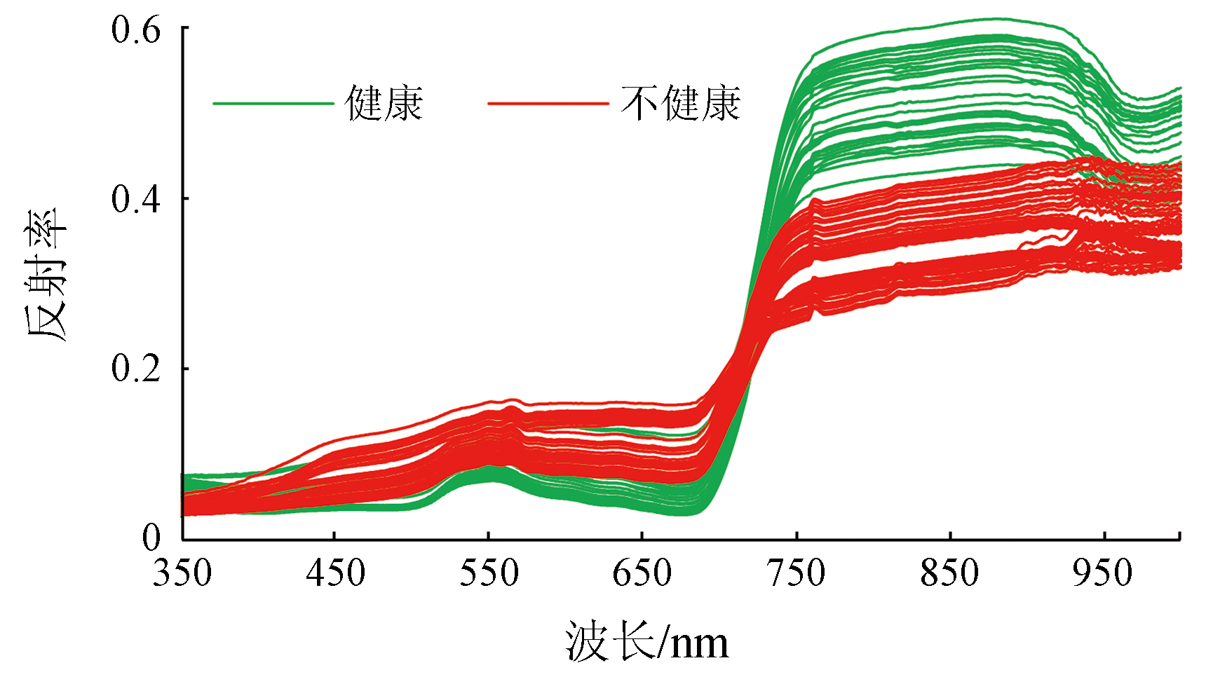
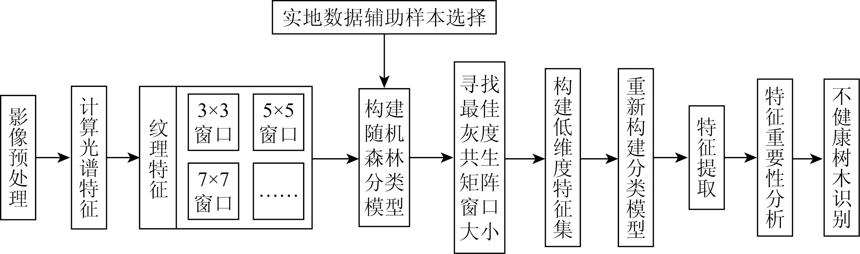
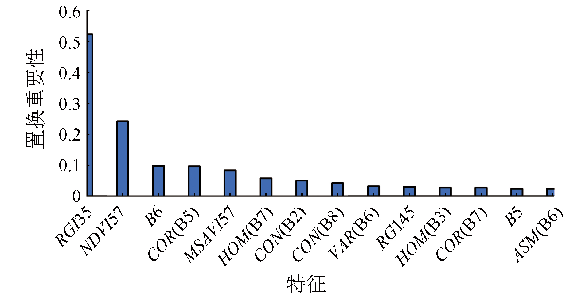
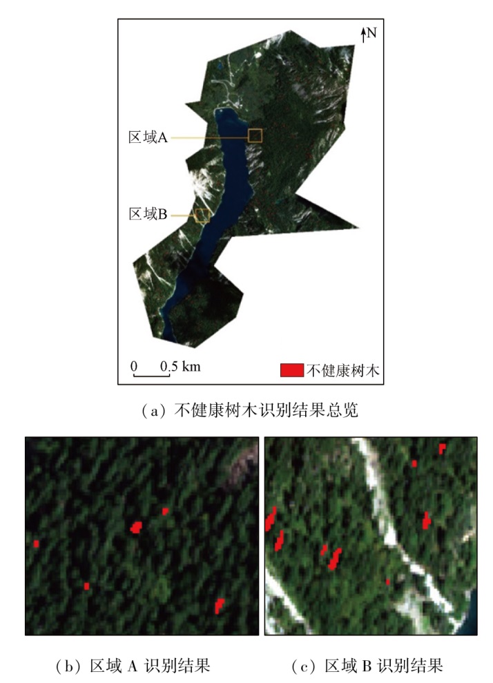
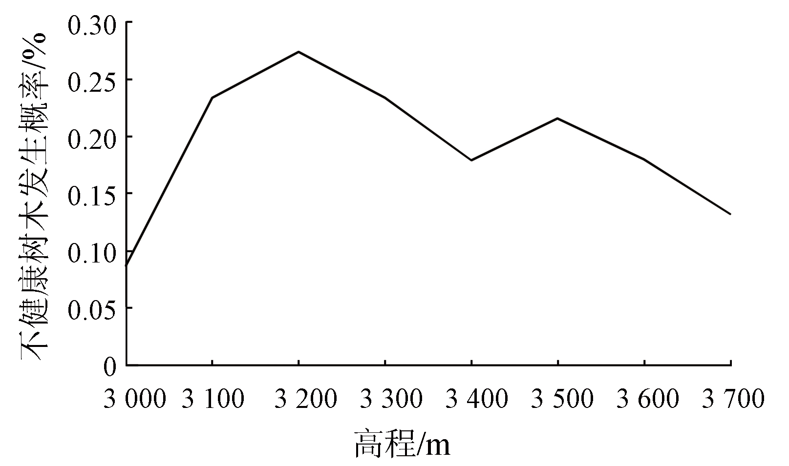
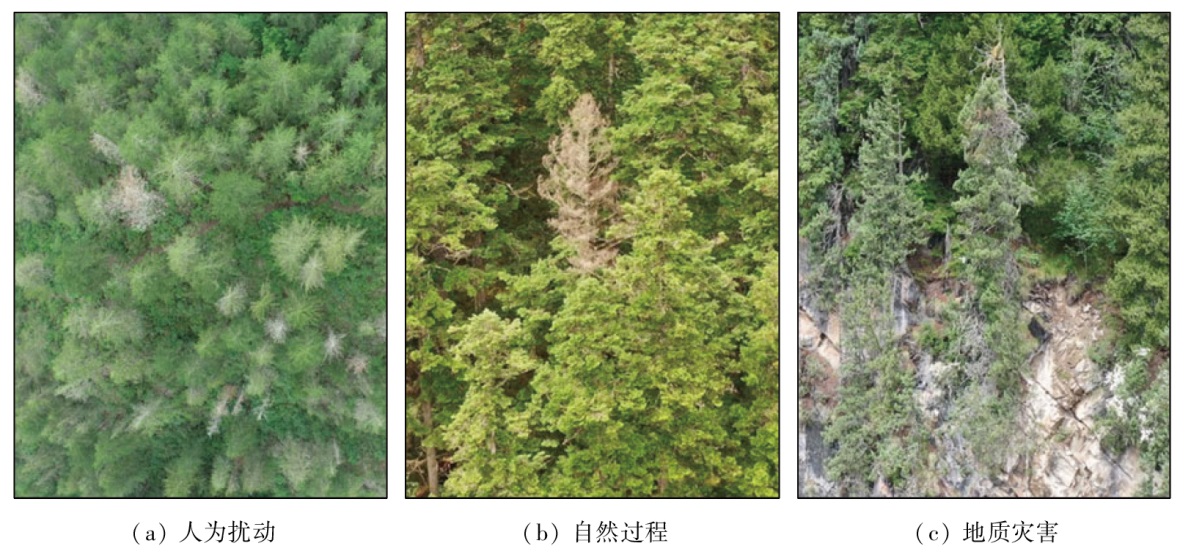
Abstract Under the intertwined effects of natural processes, geological disasters, and human disturbances, the health risks of vegetation in biosphere reserves have increased. Accurately extracting and identifying vegetation health information from complex large scenes faces technical challenges. This study investigated the Changhai pilot zone of the Jiuzhai Valley biosphere reserve by leveraging the macro, objective, and quantitative advantages of remote sensing technology. It proposed a fine-scale remote sensing monitoring method integrated with feature extraction and random forest for large-scene vegetation health, achieving the information extraction and target identification of unhealthy trees in typical biosphere reserves. The results show that: ① The random forest classification method combined with spectral and texture features can accurately extract unhealthy trees scattered in forests from high-resolution remote sensing images; ② The red-green ratio index, normalized difference vegetation index, correlation between red-edge and red bands, and corrected soil-adjusted vegetation index constitute typical features for extracting vegetation health information from remote sensing images; ③ The Changhai pilot zone exhibits a generally fair vegetation health status, with unhealthy trees accounting for 0.23%, and geological disasters exert positive effects on the spatial distribution of unhealthy trees. This study provides primary scientific data for vegetation health diagnosis of the Jiuzhai Valley biosphere reserve while showing generalization value for the remote sensing monitoring of ecological security in other biosphere reserves of China.
|
| Keywords
remote sensing
vegetation health
feature extraction
feature importance
WorldView-2
|
|
|
|
Issue Date: 14 June 2024
|
|
|
| [1] |
Batisse M. Action plan for biosphere reserves[J]. Environmental Conservation, 1985, 12(1):17-27.
|
| [2] |
Ishwaran N, Persic A, Tri N H. Concept and practice:The case of UNESCO biosphere reserves[J]. International Journal of Environment and Sustainable Development, 2008, 7(2):118-131.
|
| [3] |
Wang J, Feng L, Palmer P I, et al. Large Chinese land carbon sink estimated from atmospheric carbon dioxide data[J]. Nature, 2020, 586:720-723.
|
| [4] |
陶欢, 李存军, 程成, 等. 松材线虫病变色松树遥感监测研究进展[J]. 林业科学研究, 2020, 33(3):172-183.
|
| [4] |
Tao H, Li C J, Cheng C, et al. Progress in remote sensing monitoring for pine wilt disease induced tree mortality:A review[J]. Forest Research, 2020, 33(3):172-183.
|
| [5] |
Dash J P, Watt M S, Pearse G D, et al. Assessing very high resolution UAV imagery for monitoring forest health during a simulated disease outbreak[J]. ISPRS Journal of Photogrammetry and Remote Sensing, 2017, 131:1-14.
|
| [6] |
黄文江, 张竞成, 师越, 等. 作物病虫害遥感监测与预测研究进展[J]. 南京信息工程大学学报(自然科学版), 2018, 10(1):30-43.
|
| [6] |
Huang W J, Zhang J C, Shi Y, et al. Progress in monitoring and forecasting of crop pests and diseases by remote sensing[J]. Journal of Nanjing University of Information Science and Technology(Natural Science Edition), 2018, 10(1):30-43.
|
| [7] |
Meddens A J H, Hicke J A, Vierling L A, et al. Evaluating methods to detect bark beetle-caused tree mortality using single-date and multi-date Landsat imagery[J]. Remote Sensing of Environment, 2013, 132:49-58.
|
| [8] |
Wang H, Zhao Y, Pu R, et al. Mapping Robinia pseudoacacia forest health conditions by using combined spectral,spatial,and textural information extracted from IKONOS imagery and random forest classifier[J]. Remote Sensing, 2015, 7(7):9020-9044.
|
| [9] |
Waser L T, Küchler M, Jütte K, et al. Evaluating the potential of WorldView-2 data to classify tree species and different levels of ash mortality[J]. Remote Sensing, 2014, 6(5):4515-4545.
|
| [10] |
Näsi R, Honkavaara E, Lyytikäinen-Saarenmaa P, et al. Using UAV-based photogrammetry and hyperspectral imaging for mapping bark beetle damage at tree-level[J]. Remote Sensing, 2015, 7(11):15467-15493.
|
| [11] |
Yu R, Luo Y, Zhou Q, et al. Early detection of pine wilt disease using deep learning algorithms and UAV-based multispectral imagery[J]. Forest Ecology and Management, 2021, 497:119493.
|
| [12] |
Zhou Q, Yu L, Zhang X, et al. Fusion of UAV hyperspectral imaging and LiDAR for the early detection of EAB stress in ash and a new EAB detection index—NDVI(776,678)[J]. Remote Sensing, 2022, 14(10):2428.
|
| [13] |
薛娟, 俞琳锋, 林起楠, 等. 基于Sentinel-1多时相InSAR影像的云南松切梢小蠹危害程度监测[J]. 国土资源遥感, 2018, 30(4):108-114.doi: 10.6046/gtzyyg.2018.04.17.
|
| [13] |
Xue J, Yu L F, Lin Q N, et al. Using Sentinel-1 multi-temporal InSAR data to monitor the damage degree of shoot beetle in Yunnan pine forest[J]. Remote Sensing for Land and Resources, 2018, 30(4):108-114.doi: 10.6046/gtzyyg.2018.04.17.
|
| [14] |
He Y N, Chen G, Potter C, et al. Integrating multi-sensor remote sensing and species distribution modeling to map the spread of emerging forest disease and tree mortality[J]. Remote Sensing of Environment, 2019, 231:111238.
|
| [15] |
Wulder M A, Dymond C C, White J C, et al. Surveying mountain pine beetle damage of forests:A review of remote sensing opportunities[J]. Forest Ecology and Management, 2006, 221(1-3):27-41.
|
| [16] |
Rouse J W, Haas R H, Schell J A, et al. Monitoring vegetation systems in the Great Plains with ERTS[J]. NASA Special Publication, 1974, 351(1):309.
|
| [17] |
Gitelson A A, Kaufman Y J, Merzlyak M N. Use of a green channel in remote sensing of global vegetation from EOS-MODIS[J]. Remote Sensing of Environment, 1996, 58(3):289-298.
|
| [18] |
Wójtowicz A, Piekarczyk J, Czernecki B, et al. A random forest model for the classification of wheat and rye leaf rust symptoms based on pure spectra at leaf scale[J]. Journal of Photochemistry and Photobiology B:Biology, 2021, 223:112278.
|
| [19] |
Eitel J U, Vierling L A, Litvak M E, et al. Broadband,red-edge information from satellites improves early stress detection in a New Mexico conifer woodland[J]. Remote Sensing of Environment, 2011, 115(12):3640-3646.
|
| [20] |
Chen G, He Y N, Santis A D, et al. Assessing the impact of emerging forest disease on wildfire using Landsat and KOMPSAT-2 data[J]. Remote Sensing of Environment, 2017, 195:218-229.
|
| [21] |
Wang H, Zhong Y, Pu R, et al. Dynamic analysis of Robinia pseudoacacia forest health levels from 1995 to 2013 in the Yellow River Delta,China using multitemporal Landsat imagery[J]. International Journal of Remote Sensing, 2018, 39(12):4232-4253.
|
| [22] |
Ferreira M P, Wagner F H, Aragão L E O C, et al. Tree species classification in tropical forests using visible to shortwave infrared WorldView-3 images and texture analysis[J]. ISPRS Journal of Photogrammetry and Remote Sensing, 2019, 149:119-131.
|
| [23] |
Eugenio F C, Silva S D P, Fantinel R A, et al. Remotely piloted aircraft systems to identify pests and diseases in forest species:The global state of the art and future challenges[J]. IEEE Geoscience and Remote Sensing Magazine, 2021, 10(1):320-333.
|
| [24] |
Dash J P, Pearse G D, Watt M S. UAV multispectral imagery can complement satellite data for monitoring forest health[J]. Remote Sensing, 2018, 10(8):1216.
|
| [25] |
Liakos K G, Busato P, Moshou D, et al. Machine learning in agriculture:A review[J]. Sensors, 2018, 18(8):2674.
|
| [26] |
Park H G, Yun J P, Kim M Y, et al. Multichannel object detection for detecting suspected trees with pine wilt disease using multispectral drone imagery[J]. IEEE Journal of Selected Topics in Applied Earth Observations and Remote Sensing, 2021, 14:8350-8358.
|
| [27] |
Hu G S, Wang T X, Wan M Z, et al. UAV remote sensing monitoring of pine forest diseases based on improved Mask R-CNN[J]. International Journal of Remote Sensing, 2022, 43(4):1274-1305.
|
| [28] |
Han Z M, Hu W J, Peng S L, et al. Detection of standing dead trees after pine wilt disease outbreak with airborne remote sensing imagery by multi-scale spatial attention deep learning and Gaussian kernel approach[J]. Remote Sensing, 2022, 14(13):3075.
|
| [29] |
Mantas V, Fonseca L, Baltazar E, et al. Detection of tree decline (Pinus pinaster Aiton) in European forests using Sentinel-2 data[J]. Remote Sensing, 2022, 14(9):2028.
|
| [30] |
Haralick R M, Shanmugam K, Dinstein I H. Textural features for image classification[J]. IEEE Transactions on Systems,Man,and Cybernetics, 1973, 6:610-621.
|
| [31] |
Janitza S, Strobl C, Boulesteix A L. An AUC-based permutation variable importance measure for random forests[J]. BMC Bioinformatics, 2013, 14:119.
doi: 10.1186/1471-2105-14-119
pmid: 23560875
|
|
Viewed |
|
|
|
Full text
|
|
|
|
|
Abstract
|
|
|
|
|
Cited |
|
|
|
|
| |
Shared |
|
|
|
|
| |
Discussed |
|
|
|
|
 2024,
Vol. 36
2024,
Vol. 36