|
|
 |
|

|
|
|
Remote sensing analysis of impervious surface changes in Zhoushan Islands during 1990—2011 |
Xiaoping ZHANG1,2,3( ), Ying LYU1, Huaguo ZHANG2, Chaokui LI3 ), Ying LYU1, Huaguo ZHANG2, Chaokui LI3 |
1. School of Land and Tourism, Luoyang Normal University, Luoyang 471934, China
2. State Key Laboratory of Satellite Ocean Environment Dynamics, Second Institute of Oceanography, State Oceanic Administration, Hangzhou 310012, China
3. National-Local Joint Engineering Laboratory of Geo-spatial Information Technology, Hunan University of Science and Technology, Xiangtan 411201, China |
|
|
|
|
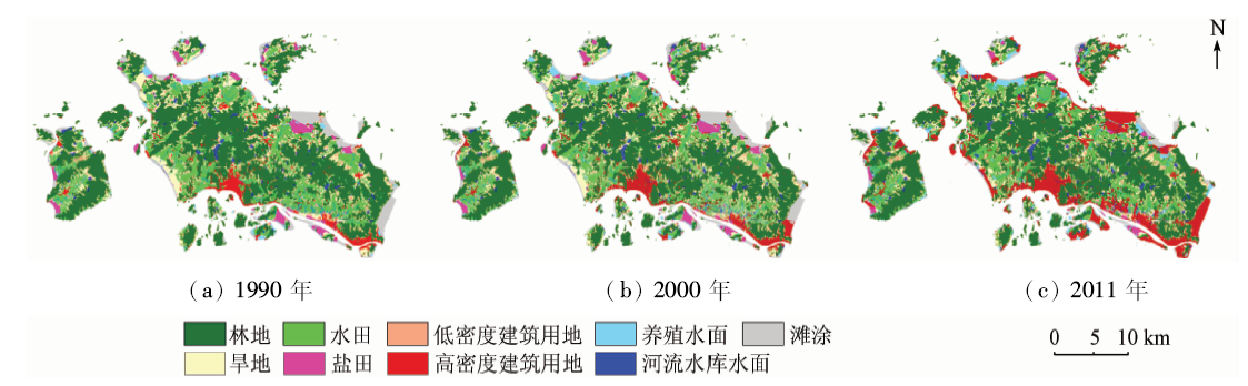
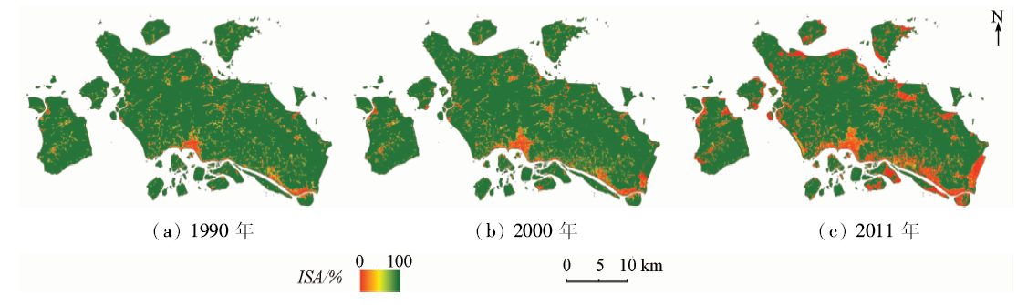
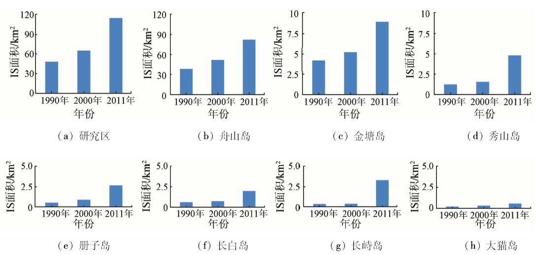
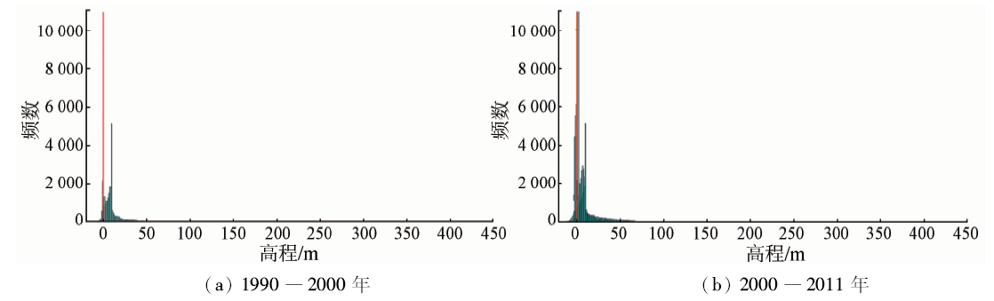
Abstract The expansion of impervious surfaces(IS)exacerbates the pollution of water resources in the island city, which is one of the important human factors affecting the vulnerability of island ecosystem. Landsat images acquired in three days of the same season were applied to monitor the dynamics of IS in Zhoushan Islands during 1990―2011. Firstly, the non-IS region was masked by the land use data set of the study area by supervised classification. Then, the complement of vegetation coverage was used to extract IS in 1990, 2000 and 2011. The results show that the IS expansions have occurred continuously over the past 20 years. The IS area in Zhoushan Islands increased from 47.96 km 2 (accounting for 6.28% of the total study area) in 1990 to 114.40 km 2 in 2011 (16.27%), and the increased IS were mostly located around the old city of Zhoushan Islands and along the periphery of surrounding islands. It is observed that the height of new IS was gradually changing to greater depth with time. The analysis indicates that the topography and the policy as well as the functions and transportation convenience are the dominant factors controlling the spatial patterns of IS and its expansions in Zhoushan Islands.
|
| Keywords
impervious surfaces(IS)
remote sensing
spatial analysis
Zhoushan Islands
|
|
|
|
Issue Date: 30 May 2018
|
|
|
| [1] |
Weng Q H . Remote sensing of impervious surfaces in the urban areas:Requirements,methods,and trends[J]. Remote Sensing of Environment, 2012,117:34-49.
doi: 10.1016/j.rse.2011.02.030
url: http://linkinghub.elsevier.com/retrieve/pii/S0034425711002811
|
| [2] |
刘珍环, 王仰麟, 彭建 . 不透水表面遥感监测及其应用研究进展[J]. 地理科学学报, 2010,29(9):1143-1152.
doi: 10.11820/dlkxjz.2010.09.018
url: http://d.wanfangdata.com.cn/Periodical/dlkxjz201009018
|
| [2] |
Liu Z H, Wang Y L, Peng J . Remote sensing of impervious surface and its applications:A review[J]. Progress in Geography, 2010,29(9):1143-1152.
|
| [3] |
Chen J Y, Pan D L, Mao Z H , et al.Land-cover reconstruction and change analysis using multi-source remotely sensed imageries in Zhoushan Islands since 1970[J]. Journal of Coastal Research, 2014,30(2):272-282.
doi: 10.2112/JCOASTRES-D-13-00027.1
url: http://www.jstor.org/stable/43290053
|
| [4] |
Carlson T N, Arthur S T . The impact of land use-land cover changes due to urbanization on surface microclimate and hydrology:A satellite perspective[J]. Global and Planetary Change, 2000,25(1/2):49-65.
doi: 10.1016/S0921-8181(00)00021-7
url: http://linkinghub.elsevier.com/retrieve/pii/S0921818100000217
|
| [5] |
Xian G, Crane M . Assessments of urban growth in the Tampa Bay watershed using remote sensing data[J]. Remote Sensing of Environment, 2005,97(2):203-215.
doi: 10.1016/j.rse.2005.04.017
url: http://linkinghub.elsevier.com/retrieve/pii/S0034425705001367
|
| [6] |
Powell R L, Roberts D A, Dennison P E , et al. Sub-pixel mapping of urban land cover using multiple endmember spectral mixture analysis:Manaus,Brazil[J]. Remote Sensing of Environment, 2007,106(2):253-267.
doi: 10.1016/j.rse.2006.09.005
url: http://linkinghub.elsevier.com/retrieve/pii/S0034425706003142
|
| [7] |
徐涵秋 . 近30 a来福州盆地中心的城市扩张进程[J]. 地理科学, 2011,31(3):351-357.
url: http://www.cqvip.com/QK/95809X/201103/37015102.html
|
| [7] |
Xu H Q .Urban expansion process in the center of the Fuzhou Basin,Southeast China in 1976―2006[J]. Scientia Geographica Sinica, 2011,31(3):351-357.
|
| [8] |
Zhang L, Weng Q H.Annual dynamics of impervious surface in the Pearl River Delta,China,from 1988 to 2013,using time series Landsat imagery[J]. ISPRS Journal of Photogrammetry and Remote Sensing, 2016,113:86-96.
doi: 10.1016/j.isprsjprs.2016.01.003
url: http://linkinghub.elsevier.com/retrieve/pii/S0924271616000113
|
| [9] |
Im J, Lu Z Y, Rhee J , et al. Impervious surface quantification using a synjournal of artificial immune networks and decision/regression trees from multi-sensor data[J]. Remote Sensing of Environment, 2012,117:102-113.
doi: 10.1016/j.rse.2011.06.024
url: http://linkinghub.elsevier.com/retrieve/pii/S0034425711002847
|
| [10] |
Zhao T, Wang J F . Use of Iidar-derived NDTI and intensity for rule-based object-oriented extraction of building footprints[J]. International Journal of Remote Sensing, 2014,35(2):578-597.
doi: 10.1080/01431161.2013.871394
url: http://www.tandfonline.com/doi/abs/10.1080/01431161.2013.871394
|
| [11] |
Yan W Y, Shaker A, El-Ashmawy N . Urban land cover classification using airborne LiDAR data:A review[J]. Remote Sensing of Environment, 2015,158:295-310.
doi: 10.1016/j.rse.2014.11.001
url: http://linkinghub.elsevier.com/retrieve/pii/S0034425714004374
|
| [12] |
李德仁, 罗晖, 邵振峰 . 遥感技术在不透水层提取中的应用与展望[J]. 武汉大学学报(信息科学版), 2016,41(5):569-577.
|
| [12] |
Li D R, Luo H, Shao Z F . Review of impervious surface mapping using remote sensing technology and its application[J]. Geomatics and Information Science of Wuhan University, 2016,41(5):569-577.
|
| [13] |
Lu D S, Li G Y, Kuang W H , et al. Methods to extract impervious surface areas from satellite images[J]. International Journal of Digital Earth, 2014,7(2):93-112.
doi: 10.1080/17538947.2013.866173
url: http://www.tandfonline.com/doi/abs/10.1080/17538947.2013.866173
|
| [14] |
黄建波.中国海岛.沙洲. 瑚礁遥感监测应用中的典型问题研究[D]. 青岛:中国海洋大学, 2006.
|
| [14] |
Huang J B . Research on Typical Questions of China Islands,Sand Banks and Coral Reefs Remote Sensing Monitoring Application[D]. Qingdao:Ocean University of China, 2006.
|
| [15] |
Zhao B, Kreuter U, Li B , et al. An ecosystem service value assessment of land-use change on Chongming Island,China[J]. Land Use Policy, 2004,21(2):139-148.
doi: 10.1016/j.landusepol.2003.10.003
url: http://linkinghub.elsevier.com/retrieve/pii/S0264837703000814
|
| [16] |
Quan B, Chen J F, Qiu H L , et al. Spatial-temporal pattern and driving forces of land use changes in Xiamen[J]. Pedosphere, 2006,16(4):477-488.
doi: 10.1016/S1002-0160(06)60078-7
url: http://linkinghub.elsevier.com/retrieve/pii/S1002016006600787
|
| [17] |
Zhang X P, Pan D L, Chen J Y , et al. Using long time series of Landsat data to monitor impervious surface dynamics:A case study in the Zhoushan Islands[J]. Journal of Applied Remote Sensing, 2013,7(1):073515.
doi: 10.1117/1.JRS.7.073515
url: http://remotesensing.spiedigitallibrary.org/article.aspx?doi=10.1117/1.JRS.7.073515
|
| [18] |
Gillies R R, Box J B, Symanzik J , et al. Effects of urbanization on the aquatic fauna of the Line Creek watershed, Atlanta-a satellite perspective[J]. Remote Sensing of Environment, 2003,86(3):411-422.
doi: 10.1016/S0034-4257(03)00082-8
url: http://linkinghub.elsevier.com/retrieve/pii/S0034425703000828
|
| [19] |
Carlson T N, Ripley D A . On the relation between NDVI,fractional vegetation cover,and leaf area index[J]. Remote Sensing of Environment, 1997,62(3):241-252.
doi: 10.1016/S0034-4257(97)00104-1
url: http://linkinghub.elsevier.com/retrieve/pii/S0034425797001041
|
| [20] |
王浩, 吴炳方, 李晓松 , 等. 流域尺度的不透水面遥感提取[J]. 遥感学报, 2011,15(2):388-400.
|
| [20] |
Wang H, Wu B F, Li X S , et al. Extraction of impervious surface in Hai Basin using remote sensing[J]. Journal of Remote Sensing, 2011,15(2):388-400.
|
|
Viewed |
|
|
|
Full text
|
|
|
|
|
Abstract
|
|
|
|
|
Cited |
|
|
|
|
| |
Shared |
|
|
|
|
| |
Discussed |
|
|
|
|
 2018,
Vol. 30
2018,
Vol. 30