|
|
 |
|

|
|
|
Extraction of hydrothermal alteration mineral groups of porphyry copper deposits using Landsat8 OLI data |
Ziyi WANG1, Tingbin ZHANG1,2,3( ), Guihua YI1, Kanghui ZHONG1, Xiaojuan BIE1, Jibin WANG1, Jiaojiao SUN1 ), Guihua YI1, Kanghui ZHONG1, Xiaojuan BIE1, Jibin WANG1, Jiaojiao SUN1 |
1. College of Earth Sciences, Chengdu University of Technology, Chengdu 610059, China
2. College of Engineering and Technical, Chengdu University of Technology, Leshan 614000, China
3. Key Laboratory of Geoscience Spatial Information Technology, Ministry of Nature Resources, Chengdu 610059, China |
|
|
|
|
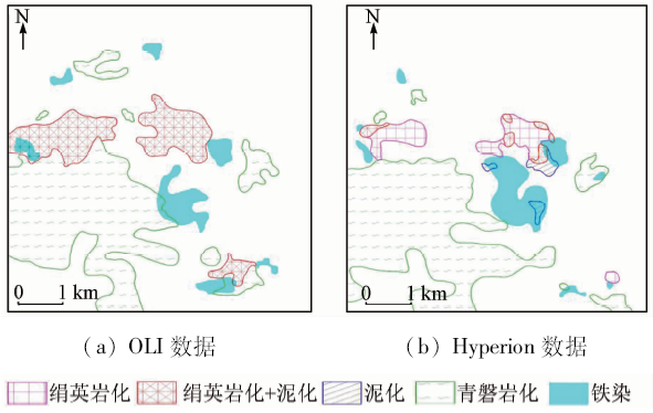
Abstract The enhancing of NIR band and SWIR2 band of OLI data makes the spectra become the diagnostic spectra of ferric iron minerals, Al-OH and Mg-OH alteration minerals. The authors used the mixture tuned matched filtering (MTMF) mapping method to extract ferric iron, Al-OH and Mg-OH alteration minerals in Tiegelong prospective block of the Duolong porphyry Cu-Au ore concentration area. Compared with the results of mineral mapping from Hyperion data, the three mineral mapping types extracted from Landsat8 OLI are reliable. At the same time, the spatial distribution pattern of alteration minerals agrees with the hydrothermal alteration zone of typical porphyry copper deposits. The remote sensing alteration zones from interior to exterior of the Tiegelong porphyry Cu ore block are phyllic+argillic zone (Al-OH minerals) and propylitic zone (Mg-OH minerals), and the ferric iron minerals are between the arephyllic+argillic and propylitic zones.
|
| Keywords
OLI
porphyry copper deposit
hydrothermal alteration mineral zones
MTMF
remote sensing
Tiegelong
|
|
|
|
Corresponding Authors:
Tingbin ZHANG
E-mail: zhangtb@cdut.edu.cn
|
|
Issue Date: 10 September 2018
|
|
|
| [1] |
Sillitoe R H . Porphyry copper systems[J]. Economic Geology, 2010,105(1):3-41.
doi: 10.2113/gsecongeo.105.1.3
url: https://pubs.geoscienceworld.org/economicgeology/article/105/1/3-41/128151
|
| [2] |
芮宗瑶, 陆彦, 李光明 , 等. 西藏斑岩铜矿的前景展望[J]. 中国地质, 2003,30(3):302-308.
|
| [2] |
Rui Z Y, Lu Y, Li G M , et al. Looking forward to the prospects of porphyry copper deposits in Tibet[J]. Geology in China, 2003,30(3):302-308.
|
| [3] |
周平 . 新常态下中国铜资源供需前景分析与预测[D].北京:中国地质大学(北京), 2015.
|
| [3] |
Zhou P . An analysis and forecast of China copper supply and demand prospects under the new normal economy[D].Beijing:China University of Geosciences( Beijing), 2015.
|
| [4] |
Lowell J D, Guilbert J M . Lateral and vertical alteration-mineralization zoning in porphyry ore deposits[J]. Economic Geology, 1970,65(4):373-408.
doi: 10.2113/gsecongeo.65.4.373
url: http://pubs.geoscienceworld.org/economicgeology/article/65/4/373/18036/Lateral-and-vertical-alterationmineralization
|
| [5] |
Rowan L C, Schmidt R G, Mars J C . Distribution of hydrothermally altered rocks in the Reko Diq,Pakistan mineralized area based on spectral analysis of ASTER data[J]. Remote Sensing of Environment, 2006,104(1):74-87.
doi: 10.1016/j.rse.2006.05.014
url: http://linkinghub.elsevier.com/retrieve/pii/S0034425706001969
|
| [6] |
Zhang T B, Yi G H, Li H M , et al. Integrating data of ASTER and landsat-8 OLI(AO) for hydrothermal alteration mineral mapping in Duolong porphyry Cu-Au deposit,Tibetan Plateau,China[J]. Remote Sensing, 2016,8(11):890.
doi: 10.3390/rs8110890
url: http://www.mdpi.com/2072-4292/8/11/890
|
| [7] |
张远飞, 袁继明, 杨自安 , 等. 基于物理意义的二维散点图类型划分与遥感蚀变信息提取[J]. 国土资源遥感, 2013,25(2):57-62.doi: 10.6046/gtzyyg.2013.02.11.
|
| [7] |
Zhang Y F, Yuan J M, Yang Z A , et al. Type classification of 2D scatter plot of remote sensing image based on the physical meaning and extraction of remote sensing alteration information[J]. Remote Sensing for Land and Resources, 2013,25(2):57-62.doi: 10.6046/gtzyyg.2013.02.11.
|
| [8] |
张远飞, 吴德文, 袁继明 , 等. 遥感蚀变信息多层次分离技术模型与应用研究[J]. 国土资源遥感, 2011,23(4):6-13.doi: 10.6046/gtzyyg.2011.04.02.
doi: 10.6046/gtzyyg.2011.04.02
|
| [8] |
Zhang Y F, Wu D W, Yuan J M , et al. The model and application of multi-level detaching technique of remote sensing alteration information[J]. Remote Sensing for Land and Resources, 2011,23(4):6-13.doi: 10.6046/gtzyyg.2011.04.02.
|
| [9] |
Yang Z A, Peng S L, Zhu G C , et al. Spectrum spatial structure characteristic analysis of remote sensing alteration information and interference factors[J]. Journal of Central South University of Technology, 2009,16(4):647-652.
doi: 10.1007/s11771-009-0107-2
url: http://link.springer.com/10.1007/s11771-009-0107-2
|
| [10] |
Sojdehee M, Rasa I, Nezafati N , et al. Application of spectral analysis to discriminate hydrothermal alteration zones at Daralu copper deposit,SE Iran[J]. Arabian Journal of Geosciences, 2015,9(1):41.
|
| [11] |
张廷斌, 唐菊兴, 李志军 , 等. 西藏尕尔穷铜金矿多光谱遥感地质特征与外围找矿预测[J]. 国土资源遥感, 2014,26(4):170-178.doi: 10.6046/gtzyyg.2014.04.27.
doi: 10.6046/gtzyyg.2014.04.27
|
| [11] |
Zhang T B, Tang J X, Li Z J , et al. Remote sensing geological characteristics and ore prediction in the Ga’erqiong Cu-Au deposit,Tibet[J]. Remote Sensing for Land and Resources, 2014,26(4):170-178.doi: 10.6046/gtzyyg.2014.04.27.
|
| [12] |
Ramadan T M, Kontny A . Mineralogical and structural characterization of alteration zones detected by orbital remote sensing at Shalatein District,SE Desert,Egypt[J]. Journal of African Earth Sciences, 2004,40(1/2):89-99.
doi: 10.1016/j.jafrearsci.2004.06.003
url: http://linkinghub.elsevier.com/retrieve/pii/S0899536204000752
|
| [13] |
Pournamdari M, Hashim M, Pour A B . Spectral transformation of ASTER and Landsat TM bands for lithological mapping of Soghan ophiolite complex,south Iran[J]. Advances in Space Research, 2014,54(4):694-709.
doi: 10.1016/j.asr.2014.04.022
url: http://linkinghub.elsevier.com/retrieve/pii/S0273117714002701
|
| [14] |
别小娟, 张廷斌, 孙传敏 , 等. 藏东罗布莎蛇绿岩遥感岩矿信息提取方法研究[J]. 国土资源遥感, 2013,25(3):72-78.doi: 10.6046/gtzyyg.2013.03.13.
doi: 10.6046/gtzyyg.2013.03.13
url: http://d.wanfangdata.com.cn/Periodical/gtzyyg201303013
|
| [14] |
Bie X J, Zhang T B, Sun C M , et al. Study of methods for extraction of remote sensing information of rocks and altered minerals from Luobusha ophiolite in East Tibet[J]. Remote Sensing for Land and Resources, 2013,25(3):72-78.doi: 10.6046/gtzyyg.2013.03.13.
|
| [15] |
Cui J, Yan B K, Wang R S , et al. Regional-scale mineral mapping using ASTER VNIR/SWIR data and validation of reflectance and mineral map products using airborne hyperspectral CASI/SASI data[J]. International Journal of Applied Earth Observation and Geoinformation, 2014,33:127-141.
doi: 10.1016/j.jag.2014.04.014
url: http://linkinghub.elsevier.com/retrieve/pii/S0303243414000981
|
| [16] |
Di Tommaso I, Rubinstein N . Hydrothermal alteration mapping using ASTER data in the Infiernillo porphyry deposit, Argentina[J]. Ore Geology Reviews, 2007,32(1/2):275-290.
doi: 10.1016/j.oregeorev.2006.05.004
url: http://linkinghub.elsevier.com/retrieve/pii/S016913680600076X
|
| [17] |
Rowan L C, Mars J C . Lithologic mapping in the Mountain Pass,California area using Advanced Spaceborne Thermal Emission and Reflection Radiometer(ASTER) data[J]. Remote Sensing of Environment, 2003,84(3):350-366.
doi: 10.1016/S0034-4257(02)00127-X
url: http://linkinghub.elsevier.com/retrieve/pii/S003442570200127X
|
| [18] |
Abbaszadeh M, Hezarkhani A . Enhancement of hydrothermal alteration zones using the spectral feature fitting method in Rabor Area,Kerman,Iran[J]. Arabian Journal of Geosciences, 2013,6(6):1957-1964.
doi: 10.1007/s12517-011-0495-0
url: http://link.springer.com/10.1007/s12517-011-0495-0
|
| [19] |
闫柏琨, 刘圣伟, 王润生 , 等. 热红外遥感定量反演地表岩石的SiO2含量[J]. 地质通报, 2006,25(5):639-643.
|
| [19] |
Yan B K, Liu S W, Wang R S , et al. Quantitative inversion of the SiO2 content in surface rocks using thermal infrared remote sensing[J]. Geological Bulletin of China, 2006,25(5):639-643.
|
| [20] |
张玉君, 曾朝铭, 陈薇 . ETM+(TM)蚀变遥感异常提取方法研究与应用——方法选择和技术流程[J]. 国土资源遥感, 2003,15(2):44-49.doi: 10.6046/gtzyyg.2003.02.11.
doi: 10.3969/j.issn.1001-070X.2003.02.011
url: http://d.wanfangdata.com.cn/Periodical_gtzyyg200302011.aspx
|
| [20] |
Zhang Y J, Zeng Z M, Chen W . The methods for extraction of alteration anomalies from the ETM+(TM) data and their application:Method selection and technological flow chart[J]. Remote Sensing for Land and Resources, 2003,15(2):44-49.doi: 10.6046/gtzyyg.2003.02.11.
|
| [21] |
张廷斌 . 斑岩铜矿遥感蚀变信息重现性与优选研究[D]. 成都:西南交通大学, 2013.
|
| [21] |
Zhang T B . On the repeatability and optimization of remote sensing mineralized alterations about the porphyry copper deposits:A case study of the typical porphyry copper deposits in Tibet[D]. Chengdu:Southwest Jiaotong University, 2013.
|
| [22] |
Pour A B, Hashim M . Hydrothermal alteration mapping from Landsat-8 data,Sar Cheshmeh copper mining district,south-eastern Islamic Republic of Iran[J]. Journal of Taibah University for Science, 2015,9(2):155-166.
doi: 10.1016/j.jtusci.2014.11.008
url: https://www.tandfonline.com/doi/full/10.1016/j.jtusci.2014.11.008
|
| [23] |
唐楠, 王成, 唐菊兴 , 等. 基于主成分分析法的OLI数据蚀变信息提取——以西藏多龙铜金矿集区为例[J]. 矿床地质, 2014,33(s1):745-746.
|
| [23] |
Tang N, Wang C, Tang J X , et al. Alteration information extraction based on principal component analysis using OLI data:A case study of Doloong Cu-Au deposit,Tibet[J] Mineral Deposits, 2014,33(s1):745-746.
|
| [24] |
程洋, 童立强 . 基于背景多层次分离的遥感矿化蚀变信息提取模型及应用实例[J]. 遥感技术与应用, 2015,30(3):586-591.
doi: 10.11873/j.issn.1004-0323.2015.3.0586
url: http://d.wanfangdata.com.cn/Periodical/ygjsyyy201503025
|
| [24] |
Cheng Y, Tong L Q . The research on model of the alteration mineral mapping base on multi-level separate background and an application examples[J]. Remote Sensing Technology and Application, 2015,30(3):586-591.
|
| [25] |
刘峻杉, 胡滨, 何政伟 . 遥感技术在格咱岛弧地区斑岩铜矿勘查中的应用[J]. 物探化探计算技术, 2015,37(6):790-796.
|
| [25] |
Liu J S, Hu B, He Z W . The application of remote sensing technique for porphyry copper exploration in the Gezan arc region[J]. Computing Techniques for Geophysical and Geochemical Exploration, 2015,37(6):790-796.
|
| [26] |
侯增谦, 吕庆田, 王安建 , 等. 初论陆-陆碰撞与成矿作用——以青藏高原造山带为例[J]. 矿床地质, 2003,22(4):319-333.
doi: 10.3969/j.issn.0258-7106.2003.04.001
url: http://d.wanfangdata.com.cn/Periodical/kcdz200304001
|
| [26] |
Hou Z Q, Lyu Q T, Wang A J , et al. Continental collision and related metallogeny:A case study of mineralization in Tibetan Orogen[J]. Mineral Deposits, 2003,22(4):319-333.
|
| [27] |
张金树 . 冈底斯成矿带东段三大斑岩型矿床地质特征及区域控岩控矿模型研究[D]. 成都:成都理工大学, 2012.
|
| [27] |
Zhang J S . Study on three porphyry-type deposits’geological features and regional structural ore-controlling model in Eastern Gandise Metallogenic Belt[D]. Chengdu:Chengdu University of Technology, 2012.
|
| [28] |
胡紫豪 . 西藏多龙斑岩型铜金矿预测工作区多元信息找矿预测[D]. 成都:成都理工大学, 2012.
|
| [28] |
Hu Z H . Multivariate information prospecting prediction of Duo-Long porphyry copper deposit forecasting area in Tibet[D]. Chengdu:Chengdu University of Technology, 2012.
|
| [29] |
孙振明 . 西藏班—怒成矿带西段多龙矿集区铜金成矿作用与成矿规律[D]. 长春:吉林大学, 2015.
|
| [29] |
Sun Z M . Copper-gold mineralization and metallogenic regularity of Duolong mineralization area in western Bangongco-Nujiang[D]. Changchun:Jilin University, 2015.
|
| [30] |
Mars J C, Rowan L C . Regional mapping of phyllic-and argillic-altered rocks in the Zagros magmatic arc,Iran,using advanced spaceborne thermal emission and reflection radiometer(ASTER) data and logical operator algorithms[J]. Geosphere, 2006,2(3):161-186.
doi: 10.1130/GES00044.1
url: https://pubs.geoscienceworld.org/geosphere/article/2/3/161-186/31132
|
| [31] |
Bedini E . Mapping alteration minerals at Malmbjerg molybdenum deposit,central East Greenland,by Kohonen self-organizing maps and matched filter analysis of HyMap data[J]. International Journal of Remote Sensing, 2012,33(4):939-961.
doi: 10.1080/01431161.2010.542202
url: https://www.tandfonline.com/doi/full/10.1080/01431161.2010.542202
|
| [32] |
Clark R N, Swayze G A, Wise R A , et al. USGS Digital Spectral Library Splib06a[R].[s.l.]:U.S. Geological Survey, 2007.
|
| [33] |
Cudahy T J, Ramanaidou E R . Measurement of the hematite:Goethite ratio using field visible and near-infrared reflectance spectrometry in channel iron deposits,Western Australia[J]. Australian Journal of Earth Sciences, 1997,44(4):411-420.
doi: 10.1080/08120099708728322
url: http://www.tandfonline.com/doi/abs/10.1080/08120099708728322
|
| [34] |
Molan Y E, Refahib D, Tarashti A H . Mineral mapping in the Maherabad area,eastern Iran,using the HyMap remote sensing data[J]. International Journal of Applied Earth Observation and Geoinformation, 2014,27:117-127.
doi: 10.1016/j.jag.2013.09.014
url: http://linkinghub.elsevier.com/retrieve/pii/S030324341300113X
|
| [35] |
张玉君 . Landsat8简介[J]. 国土资源遥感, 2013,25(1):176-177.
|
| [35] |
Zhang Y J . Introduction of Landsat8[J] Remote Sensing for Land and Resources[J], 2013,25(1):176-177.
|
| [36] |
Kruse F A, Baugh W M, Perry S L . Validation of DigitalGlobe WorldView-3 Earth imaging satellite shortwave infrared bands for mineral mapping[J]. Journal of Applied Remote Sensing, 2015,9(1):096044.
doi: 10.1117/1.JRS.9.096044
url: http://remotesensing.spiedigitallibrary.org/article.aspx?doi=10.1117/1.JRS.9.096044
|
| [37] |
Asadzadeh S, De Souza Filho C R .A review on spectral processing methods for geological remote sensing[J]. International Journal of Applied Earth Observation and Geoinformation, 2016,47:69-90.
doi: 10.1016/j.jag.2015.12.004
url: http://linkinghub.elsevier.com/retrieve/pii/S0303243415300696
|
| [38] |
Boardman J W, Kruse F A . Analysis of imaging spectrometer data using N-dimensional geometry and a mixture-tuned matched filtering approach[J]. IEEE Transactions on Geoscience and Remote Sensing, 2011,49(11):4138-4152.
doi: 10.1109/TGRS.2011.2161585
url: http://ieeexplore.ieee.org/document/5985518/
|
| [39] |
闫柏琨, 董新丰, 王喆 , 等. 航空高光谱遥感矿物信息提取技术及其应用进展——以中国西部成矿带调查为例[J]. 中国地质调查, 2016,3(4):55-62.
|
| [39] |
Yan B K, Dong X F, Wang Z , et al. Mineral information extraction technology by airborne hyperspectral remote sensing and its application progress:An example of mineralization belts of western China[J]. 2016,3(4):55-62.
|
|
Viewed |
|
|
|
Full text
|
|
|
|
|
Abstract
|
|
|
|
|
Cited |
|
|
|
|
| |
Shared |
|
|
|
|
| |
Discussed |
|
|
|
|
 2018,
Vol. 30
2018,
Vol. 30