|
|
 |
|

|
|
|
Sparse coefficient NMF fusion via PCA united dictionary |
| Xiaofang SUN |
| Department of Geography, Minjiang College, Fuzhou 350121, China |
|
|
|
|
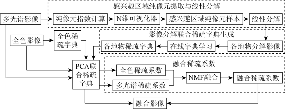
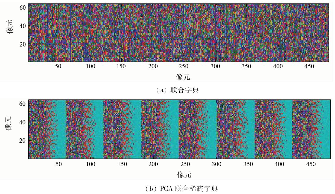
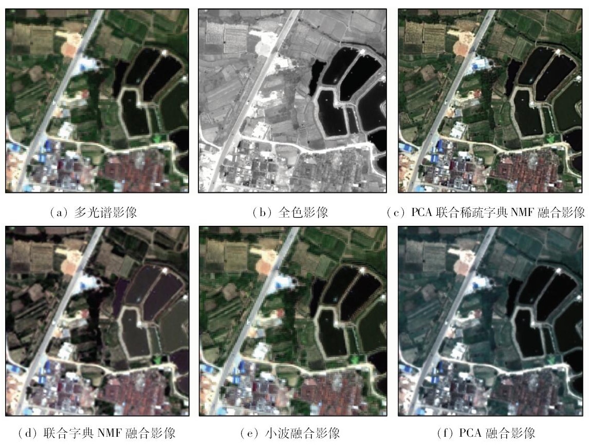
Abstract In order to reduce the influence of mixed pixel on dictionary, the author has constituted principal component analysis (PCA)united sparse dictionary from the first principal component extracted with sparse dictionary of panchromatic image and unmiximg image by the online dictionary learning algorithm and PCA. The sparse dictionary can include multi-spectral image and high-spatial resolution image features, while considering the mixed pixel problem. The sparse coefficients of panchromatic and multi-spectral images are calculated using PCA united sparse dictionary and orthogonal matching pursuit(OMP) algorithm, then the sparse coefficients of fusion image are calculated using nonnegative matrix factor(NMF) fusion algorithm, thus reconstructing fusion image. In consideration of the root mean square error of the reconstructed image and the limitation of computing, research on the dictionary matrix size shows that the final matrix size of sparse dictionary is 64×480. An analysis of five quantitative assessment indexes demonstrates that more texture details and multi-spectral information can be obtained by the proposed fusion than by united sparse dictionary NMF fusion, wavelet fusion and PCA fusion. The proposed method can obtain better fusion result.
|
| Keywords
PCA united sparse dictionary
online dictionary learning algorithm
OMP algorithm
NMF fusion
|
|
|
|
Issue Date: 07 December 2018
|
|
|
| [1] |
向馗, 李炳南 . 主元分析中的稀疏性[J]. 电子学报, 2012,40(12):2525-2532.
|
| [1] |
Xiang K, Li B N . Sparsity in principal component analysis:A survey[J]. Acta Electronica Sinica, 2012,40(12):2525-2532.
|
| [2] |
梁锐华, 成礼智 . 基于小波域字典学习方法的图像双重稀疏表示[J]. 国防科技大学学报, 2012,34(4):126-131.
doi: 10.3969/j.issn.1001-2486.2012.04.025
url: http://d.wanfangdata.com.cn/Periodical/gfkjdxxb201204025
|
| [2] |
Liang R H, Cheng L Z . Double sparse image representation via learning dictionaries in wavelet domain[J]. Journal of National University of Defense Technology, 2012,34(4):126-131.
|
| [3] |
Iqbal M, Chen J . Unification of image fusion and super-resolution using jointly trained dictionaries and local information contents[J]. IET Image Processing, 2012,6(9):1299-1310.
doi: 10.1049/iet-ipr.2012.0122
url: https://digital-library.theiet.org/content/journals/10.1049/iet-ipr.2012.0122
|
| [4] |
孙玉宝, 韦志辉, 肖亮 , 等. 多形态稀疏性正则化的图像超分辨率算法[J]. 电子学报, 2010,38(12):2898-2903.
doi:
url: http://www.cqvip.com/Main/Detail.aspx?id=36597444
|
| [4] |
Sun Y B, Wei Z H, Xiao L , et al. Multimorphology sparsity regularized image super-resolution[J]. Acta Electronica Sinica, 2010,38(12):2898-2903.
|
| [5] |
Liu Y, Wang Z F. Multi-focus image fusion based on sparse representation with adaptive sparse domain selection[C]// 2013 Seventh International Conference on Image and Graphics.Qingdao:IEEE, 2013: 591-596.
|
| [6] |
Huang B, Song H H, Cui H B , et al. Spatial and spectral image fusion using sparse matrix factorization[J]. IEEE Transactions on Geoscience and Remote Sensing, 2013,52(3):1693-1704.
doi: 10.1109/TGRS.2013.2253612
url: http://ieeexplore.ieee.org/document/6516902
|
| [7] |
Song H H, Huang B, Liu Q S , et al. Improving the spatial resolution of Landsat TM/ETM+ through fusion with SPOT5 images via learning-based super-resolution[J]. IEEE Transactions on Geoscience and Remote Sensing, 2014,53(3):1195-1204.
doi: 10.1109/TGRS.2014.2335818
url: http://ieeexplore.ieee.org/document/6866167/
|
| [8] |
Li S T, Yin H T, Fang L Y . Remote sensing image fusion via sparse representations over learned dictionaries[J]. IEEE Transactions on Geoscience and Remote Sensing, 2013,51(9):4779-4789.
doi: 10.1109/TGRS.2012.2230332
url: http://ieeexplore.ieee.org/document/6428669/
|
| [9] |
魏士俨, 李群智, 马友青 , 等. 虹湾影像超分辨率重建[J]. 光电工程, 2012,39(12):86-90.
url: http://www.opticsjournal.net/Articles/Abstract?aid=OJ121214000106B9EbHd
|
| [9] |
Wei S Y, Li Q Z, Ma Y Q , et al. Sinus iridum images super resolution reconstruction[J]. Opto-Electronic Engineering, 2012,39(12):86-90.
|
| [10] |
张垚, 徐斌, 周尚波 , 等. 基于稀疏表示的自适应图像超分辨率重建算法[J]. 计算机应用研究, 2013,30(3):938-941.
doi: 10.3969/j.issn.1001-3695.2013.03.077
url: http://www.cqvip.com/QK/93231X/201303/44961029.html
|
| [10] |
Zhang Y, Xu B, Zhou S B , et al. Image super-resolution with adaptive regularization sparse representation[J]. Application Research of Computers, 2013,30(3):938-941.
|
| [11] |
薛模根, 徐国明 . 聚类字典下集中式稀疏表示的幻觉脸重建方法[J]. 系统工程与电子技术, 2014,36(1):187-193.
doi: 10.3969/j.issn.1001-506X.2014.01.30
url: http://d.wanfangdata.com.cn/Periodical/xtgcydzjs201401030
|
| [11] |
Xue M G, Xu G M . Hallucinating faces reconstruction method via centralized sparse representation based on clustered dictionary[J]. Systems Engineering and Electronics, 2014,36(1):187-193.
|
| [12] |
何同弟, 李见为 . 基于自适应稀疏表示的高光谱遥感图像分类[J]. 系统工程与电子技术, 2013,35(9):1994-1998.
doi: 10.3969/j.issn.1001-506X.2013.09.32
url: http://d.wanfangdata.com.cn/Periodical/xtgcydzjs201309032
|
| [12] |
He T D, Li J W . Hyperspectral remote sensing image classification based on adaptive sparse representation[J]. Systems Engineering and Electronics, 2013,35(9):1994-1998.
|
| [13] |
严春满, 郭宝龙, 易盟 . 自适应字典学习的多聚焦图像融合[J]. 中国图象图形学报, 2012,17(9):1144-1149.
|
| [13] |
Yan C M, Guo B L, Yi M . Multi-focus image fusion using adaptive dictionary learning method[J]. Journal of Image and Graphics, 2012,17(9):1144-1149.
|
| [14] |
刘婷, 程建 . 小波变换和稀疏表示相结合的遥感图像融合[J]. 中国图象图形学报, 2013,18(8):1045-1053.
doi: 10.11834/jig.20130820
url: http://d.wanfangdata.com.cn/Periodical/zgtxtxxb-a201308020
|
| [14] |
Liu T, Cheng J . Remote sensing image fusion with wavelet transform and sparse representation[J]. Journal of Image and Graphics, 2013,18(8):1045-1053.
|
| [15] |
王斐, 梁晓庚, 崔彦凯 , 等. 非负矩阵分解和新轮廓波变换的图像融合[J]. 计算机工程与应用, 2013,49(5):150-153.
doi: 10.3778/j.issn.1002-8331.1111-0555
url: http://www.cqvip.com/QK/91690X/201305/44967541.html
|
| [15] |
Wang F, Liang X G, Cui Y K , et al. Image fusion combined with NMF and new contourlet transform[J]. Computer Engineering and Applications, 2013,49(5):150-153.
|
|
Viewed |
|
|
|
Full text
|
|
|
|
|
Abstract
|
|
|
|
|
Cited |
|
|
|
|
| |
Shared |
|
|
|
|
| |
Discussed |
|
|
|
|
 2018,
Vol. 30
2018,
Vol. 30