|
|
 |
|

|
|
|
Complex scene classification of remote sensing images based on CNN |
| Kang ZHANG1,2,3, Baoqin HEI1,2, Shengyang LI1,2, Yuyang SHAO1,2 |
1. Technology and Engineering Center for Space Utilization, Chinese Academy of Sciences, Beijing 100094, China
2. Key Laboratory of Space Utilization, Chinese Academy of Sciences, Beijing 100094, China
3. University of Chinese Academy of Sciences, Beijing 100049, China |
|
|
|
|
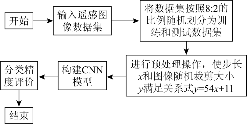
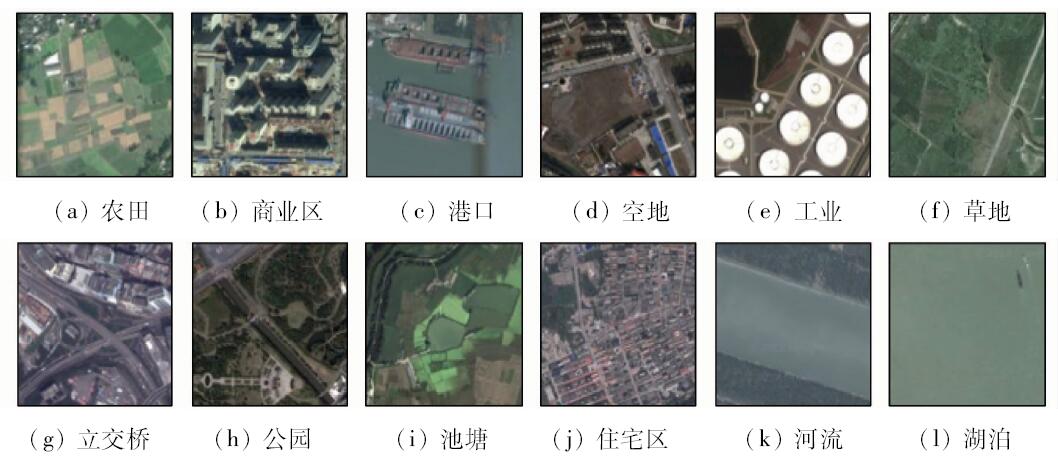
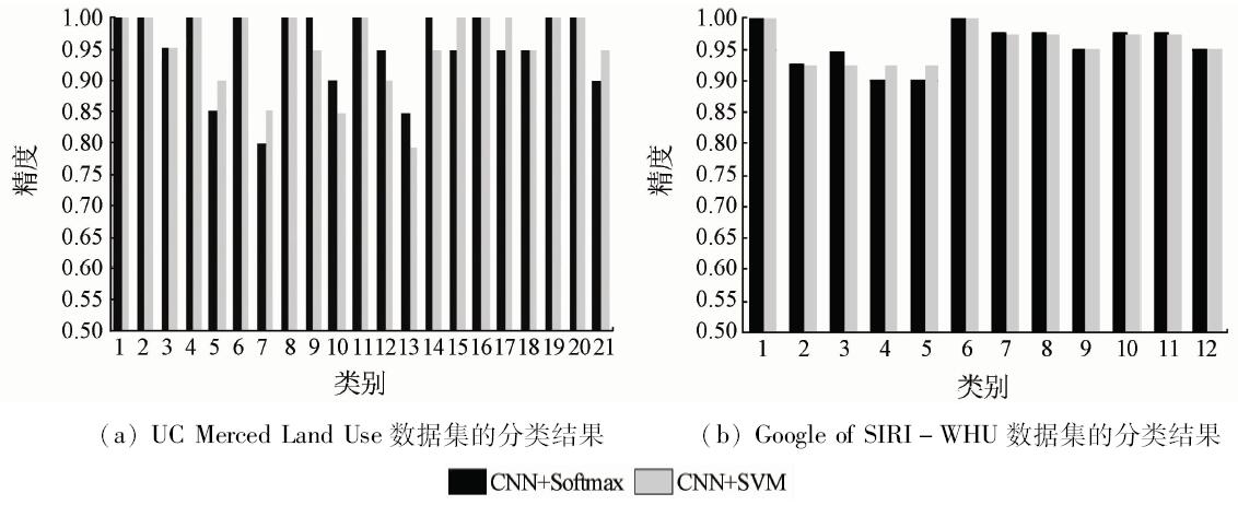
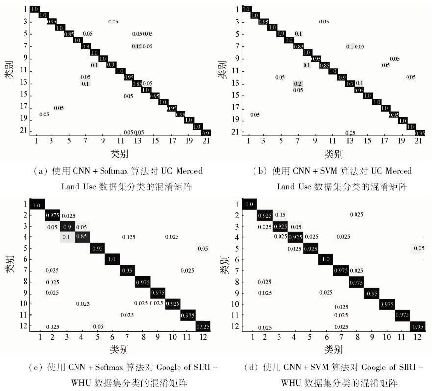
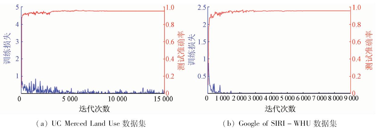
Abstract Complex scene classification has great significance for mining the value information in remote sensing images. The proposed convolutional neural networks (CNN) can improve the complex scene classification of remote sensing images. The CNN method extracts features automatically, avoiding problems in the image pretreatment and the feature extraction by manual labor. An eight-layer CNN model is constructed in this paper, and the pre-treatment module has enhanced the adaptability of this method. Given the problem in choosing classifiers, this paper provides the Softmax and support vector machine (SVM) in the presented CNN. The experiment results in two datasets, the UC Merced Land Use and the Google of SIRI-WHU indicate that the presented CNN method can increase the accuracy of classification by more than 2% compared with the CNN with Overfeat feature method and the SRSCNN method, and the total classification accuracy of the two classifiers is over 95%.
|
| Keywords
convolutional neutral networks
deep learning
remote sensing images
scene classification
support vector machine
|
|
|
|
Issue Date: 07 December 2018
|
|
|
| [1] |
Liu Z Y . Remote sensing land use change monitoring based on special chart restriction[J]. Journal of Anhui Agricultural Sciences, 2011.
url: http://en.cnki.com.cn/Article_en/CJFDTOTAL-AHNY201122165.htm
|
| [2] |
Voogt J A, Oke T R . Thermal remote sensing of urban climates[J]. Remote Sensing of Environment, 2003,86(3):370-384.
doi: 10.1016/S0034-4257(03)00079-8
url: http://linkinghub.elsevier.com/retrieve/pii/S0034425703000798
|
| [3] |
许夙晖, 慕晓冬, 柯冰 , 等. 基于遥感影像的军事阵地动态监测技术研究[J]. 遥感技术与应用, 2014,29(3):511-516.
|
| [3] |
Xu S H, Mu X D, Ke B , et al. Dynamic monitoring of military position based on remote sensing image[J]. Remote Sensing Technology and Application, 2014,29(3):511-516.
|
| [4] |
王治中, 张庆君, 吕科 . 大数据时代航天遥感系统的挑战和机遇[J].工程研究-跨学科视野中的工程, 2014(3):244-258.
|
| [4] |
Wang Z Z, Zhang Q J, Lyu K . A brief analysis of challenges and opportunities of space remote sensing system in the big data age[J].Journal of Engineering Studies, 2014(3):244-258
|
| [5] |
Duda R O, Hart P E, Stork D G . Pattern Classification[M]. New York:Wiley, 1998: 55-88.
|
| [6] |
Li Q, Bao W, Li X, et al. High resolution remote sensing image classification based on SVM and FCM [C]// International Conference on Electrical,Computer Engineering and Electronics. 2015.
|
| [7] |
邓曾, 李丹, 柯樱海 , 等. 基于改进SVM算法的高分辨率遥感影像分类[J]. 国土资源遥感, 2016,28(3):12-18.doi: 10.6046/gtzyyg.2016.03.03.
doi: 10.6046/gtzyyg.2016.03.03
url: http://d.wanfangdata.com.cn/Periodical/gtzyyg201603003
|
| [7] |
Deng Z, Li D, Ke Y H , et al. An improved SVM algorithm for high spatial resolution remote sensing image classification[J]. Remote Sensing for Land and Resources, 2016,28(3):12-18.doi: 10.6046/gtzyyg.2016.03.03.
|
| [8] |
阎继宁, 周可法, 王金林 , 等. 基于SAM与SVM的高光谱遥感蚀变信息提取[J]. 计算机工程与应用, 2013,49(19):141-146.
|
| [8] |
Yan J N, Zhou K F, Wang J L , et al. Extraction of hyper-spectral remote sensing alteration information based on SAM and SVM[J]. Computer Engineering and Applications, 2013,49(19):141-146.
|
| [9] |
Wu M, Chen L. Image recognition based on deep learning [C]// Chinese Automation Congress.IEEE, 2015.
|
| [10] |
曹林林, 李海涛, 韩颜顺 , 等. 卷积神经网络在高分遥感影像分类中的应用[J]. 测绘科学, 2016,41(9):170-175.
doi: 10.16251/j.cnki.1009-2307.2016.09.033
url: http://d.wanfangdata.com.cn/Periodical/chkx201609033
|
| [10] |
Cao L L, Li H T, Han Y S , et al. Application of convolutional neural networks in classification of high resolution remote sensing imagery[J]. Science of Surveying and Mapping, 2016,41(9):170-175.
|
| [11] |
Hinton G E, Salakhutdinov R R . Reducing the dimensionality of data with neural networks[J]. Science, 2006,313(5786):504.
doi: 10.1126/science.1127647
url: http://www.sciencemag.org/cgi/doi/10.1126/science.1127647
|
| [12] |
芮挺, 费建超, 周遊 , 等. 基于深度卷积神经网络的行人检测[J]. 计算机工程与应用, 2016,52(13):162-166.
|
| [12] |
Rui T, Fei J C, Zhou Y , et al. Pedestrian detection based on deep convolutional neural network[J]. Computer Engineering and Applications, 2016,52(13):162-166.
|
| [13] |
Zhang Q, Xu J, Xu L , et al. Deep convolutional neural networks for forest fire detection[C]//2016 International Forum on Management,Education and Information Technology Application.Atlantis Press, 2016.
|
| [14] |
Zhang R, Yao J, Zhang K , et al.S-CNN ship detection from high-resolution remote sensing images[J].ISPRS, 2016, B7:423-430.
|
| [15] |
Krizhevsky A, Sutskever I, Hinton G E . ImageNet classification with deep convolutional neural networks[J]. Advances in Neural Information Processing Systems, 2012,25(2):2012.
doi: 10.1145/3065386
url: http://dl.acm.org/citation.cfm?id=2999257
|
| [16] |
Girshick R, Donahue J, Darrell T , et al. Rich feature hierarchies for accurate object detection and semantic segmentation[J]. Computer Science, 2014: 580-587.
doi: 10.1109/CVPR.2014.81
url: http://www.computer.org/csdl/proceedings/cvpr/2014/5118/00/5118a580-abs.html
|
| [17] |
Yosinski J, Clune J, Bengio Y , et al. How transferable are features in deep neural networks?[J]. Eprint Arxiv, 2014,27:3320-3328.
|
| [18] |
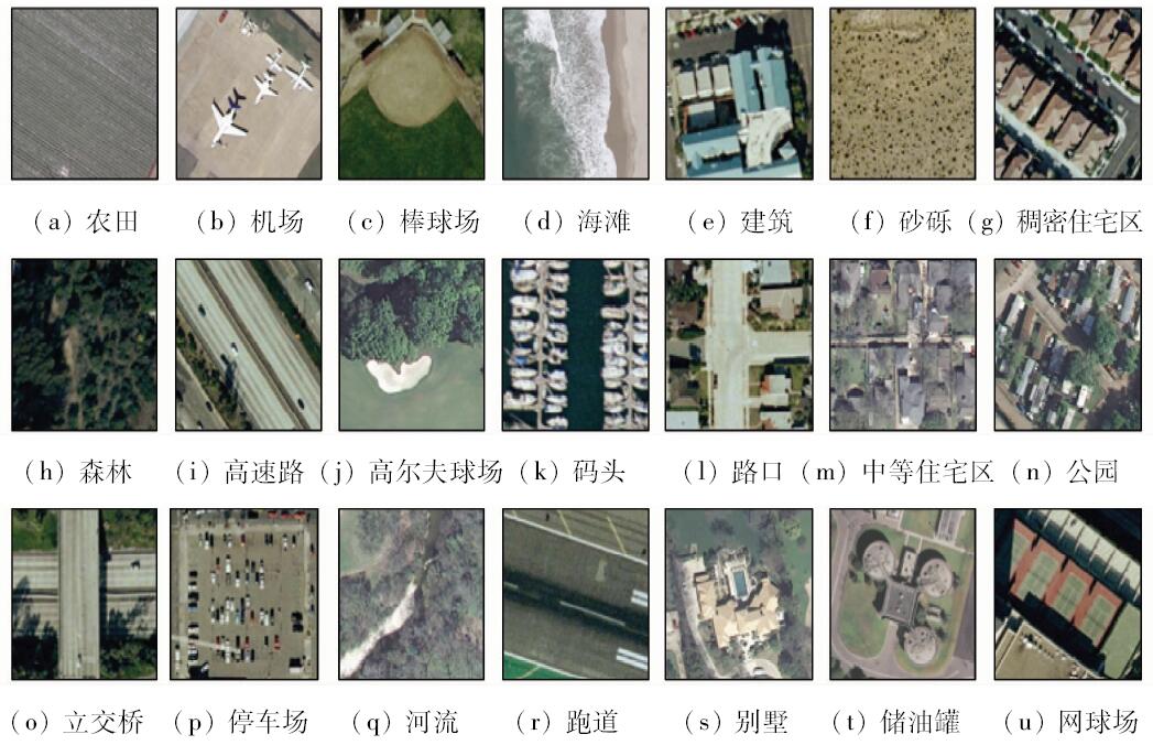
UC Merced Land Use Dataset[DB/OL].( 2010- 10- 28)[2017-16]. .
url: http://vision.ucmerced.edu/datasets/landuse.html
|
| [19] |
Zhao B, Zhong Y, Xia G S , et al. Dirichlet-derived multiple topic scene classification model fusing heterogeneous features for high resolution remote sensing imagery[J]. IEEE Transactions on Geoscience and Remote Sensing, 2015,54(4):2108-2123.
|
| [20] |
Liu Y, Zhong Y, Fei F, et al. Scene semantic classification based on random-scale stretched convolutional neural network for high-spatial resolution remote sensing imagery[C]// IGARSS 2016-2016 IEEE International Geoscience and Remote Sensing Symposium.IEEE, 2016: 763-766.
|
| [21] |
许夙晖, 慕晓冬, 赵鹏 , 等. 利用多尺度特征与深度网络对遥感影像进行场景分类[J]. 测绘学报, 2016,45(7):834-840.
doi: 10.11947/j.AGCS.2016.20150623
url: http://www.cqvip.com/QK/90069X/201607/669676004.html
|
| [21] |
Xu S H, Mu X D, Zhao P , et al. Scene classification of remote sensing image based on multi-scale feature and deep neural network[J]. Acta Geodaetica et Cartographica Sinica, 2016,45(7):834-840.
|
| [22] |
Yang Y, Newsam S. Spatial pyramid co-occurrence for image classification [C]// International Conference on Computer Vision.IEEE, 2011: 1465-1472.
|
| [23] |
Marmanis D, Datcu M, Esch T , et al. Deep learning earth observation classification using imagenet pretrained networks[J]. IEEE Geoscience and Remote Sensing Letters, 2015,13(1):1-5.
doi: 10.1109/LGRS.2015.2499239
url: http://ieeexplore.ieee.org/document/7342907/
|
|
Viewed |
|
|
|
Full text
|
|
|
|
|
Abstract
|
|
|
|
|
Cited |
|
|
|
|
| |
Shared |
|
|
|
|
| |
Discussed |
|
|
|
|
 2018,
Vol. 30
2018,
Vol. 30