|
|
 |
|

|
|
|
Research and production of a lenticular stereoscopic subsidence map |
Jinghui FAN1, Ruyi WANG2( ), Hongli ZHAO1, Yanming LI3, Hao LIN4, Yunpeng YAN1 ), Hongli ZHAO1, Yanming LI3, Hao LIN4, Yunpeng YAN1 |
1. China Aero Geophysical Survey and Remote Sensing Center for Land and Resources, Beijing 100083, China
2. China Zhengyuan Geomatics Co., Ltd., Ji’nan 250101, China;
3. Beijing Graphics and Image Information Technology Co., Ltd., Beijing 100083, China
4. Xinyang Normal University, Xinyang 464000, China |
|
|
|
|
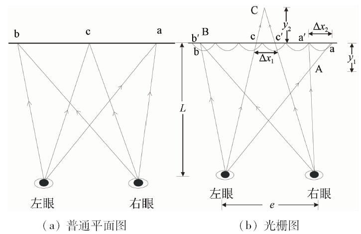
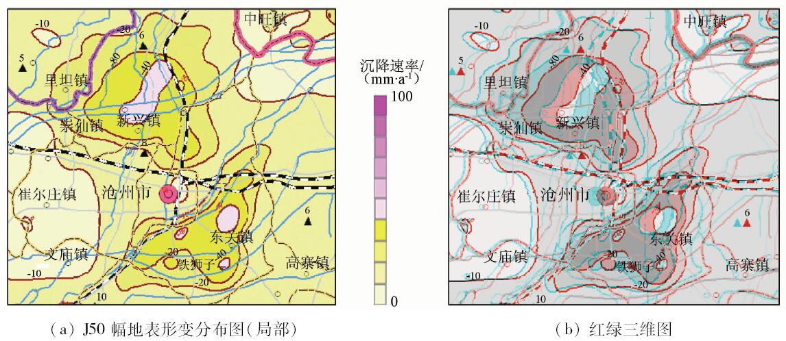
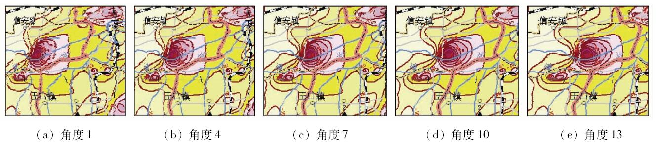
Abstract Lenticular stereoscopic images have been widely used in the three-dimensional expression of characters, landscapes and geomorphic features, but they have not yet been found in the visualization of depression shape of regional subsidence. Based on the research and introduction of the lenticular stereoscopic principle, the authors produced a lenticular stereoscopic subsidence map. The J50 thematic map of land subsidence at the scale of 1:1 000 000 was used as the data source. After the three-dimensional simulation using the subsidence isoline, the images series with different viewing angles were generated based on the simulated scene. Then, the images series were sampled and arranged to compose the base map. Finally, the base map was printed on the lenticular plate and properly processed. The research shows that the subsidence field can be innovatively and intuitively visualized using 3D GIS, digital image processing and lenticular stereoscopic technology.
|
| Keywords
lenticular stereoscopic map
subsidence
three-dimensional visualization
|
|
|
|
Corresponding Authors:
Ruyi WANG
E-mail: ruyi06@163.com
|
|
Issue Date: 07 December 2018
|
|
|
| [1] |
Roberts D E . History of lenticular and related autostereoscopic methods[Z]. Hillsboro:Leap Technologies,LLC, 2003.
|
| [2] |
史瑞芝 . 光栅立体印刷技术综述[J]. 中国印刷与包装研究, 2009,1(5):1-9.
doi: 10.3969/j.issn.1674-5752.2009.05.001
url: http://d.wanfangdata.com.cn/Periodical/zgysybzyj200905001
|
| [2] |
Shi R Z . Summary of grating stereoscopic printing technology[J]. China Printing and Packaging Study, 2009,1(5):1-9.
|
| [3] |
Johnson R B, Jacobsen G A. Advances in lenticular lens arrays for visual display [C]//Mouroulis P Z,Smith W J,Johnson R B.Current Developments in Lens Design and Optical Engineering VI.San Diego:SPIE, 2005.
|
| [4] |
Buchroithner M F, Knust C . True-3D in cartography-current hard- and softcopy developments[M] //Moore A,Drecki I.Geospatial Visualisation.Berlin Heidelberg:Springer, 2013: 41-65.
|
| [5] |
Moellering H . Perspectives on 3D visualization of spatial geodata and future prospects[M] // Buchroithner M.True-3D in Cartography.Berlin Heidelberg:Springer, 2012: 1-19.
|
| [6] |
史瑞芝, 安敬 . 一种基于柱镜光栅成像技术制作立体影像图的方法[J].测绘通报, 2008(11):31-33.
url: http://www.cqvip.com/Main/Detail.aspx?id=28814142
|
| [6] |
Shi R Z, An J . A method of composite stereo photomap based on lenticular screen[J].Bulletin of Surveying and Mapping,2008(11):31-33.
|
| [7] |
彭爱华, 朱化凤 . 应用于立体印刷的矩阵式透镜光栅的原理[J]. 燕山大学学报, 2010,34(3):262-265.
doi: 10.3969/j.issn.1007-791X.2010.03.016
url: http://www.cqvip.com/QK/93237A/201003/34249504.html
|
| [7] |
Peng A H, Zhu H F . Principium of matrix lens grating in three-dimensional printing[J]. Journal of Yanshan University, 2010,34(3):262-265.
|
| [8] |
李鹏 . 立体印刷的成像原理[J].印刷质量与标准化, 2007(3):8-11.
|
| [8] |
Li P . The imaging elements of 3D printing[J].Printing Quality and Standardization,2007(3):8-11.
|
| [9] |
周立权 . 光栅立体印刷图像处理技术研究[J]. 包装工程, 2010,31(3):107-110,136.
|
| [9] |
Zhou L Q . Research on image-processing technology of stereoscopic printing[J]. Packaging Engineering, 2010,31(3):107-110,136.
|
| [10] |
董永贵, 沈立, 冯冠平 , 等. 一种基于柱透镜光栅的计算机辅助彩色立体图片合成方法[J].光学技术, 1999(3):66-68.
doi: 10.3321/j.issn:1002-1582.1999.03.016
url: http://www.cqvip.com/QK/91230X/199903/3588955.html
|
| [10] |
Dong Y G, Shen L, Feng G P , et al. Computer-aided composite method of the lenticular screen covering color stereo-image[J].Optical Technology,1999(3):66-68.
|
| [11] |
康立民 . 立体照片的拍摄及合成[J]. 北京机械工业学院学报, 1996,11(2):30-42.
|
| [11] |
Kang L M . Discusses shoot and composite of the stereogram[J]. Journal of Beijing Institute of Machinery Industry, 1996,11(2):30-42.
|
| [12] |
大越孝敬. 三维成像技术[M]. 董太和译.北京: 机械工业出版社, 1982.
|
| [12] |
Takanori. Three-Dimensional Imaging Techniques[M]. Dong T H, transl.Beijing:China Machine Press, 1982.
|
| [13] |
侯卫兵 . 大幅面彩色喷涂系统及相关技术的研究[D]. 北京:清华大学, 1997.
|
| [14] |
Ignat’ev N K . Two modes of operation of a lens array for obtaining integral photography[J]. Soviet Journal of Optical Technology, 1983,50(1):6-8.
|
| [15] |
Pollard S B, Mayhew J E W, Frisby J P . Implementation details of the PMF stereo algorithm[M] //Mayhew J E W, Frisby J P.3D Model Recognition from Stereoscopic Cues.Cambridge:MIT Press, 1991.
|
| [16] |
黄敏, 刘浩学 . 立体印刷制作工艺光栅板参数的选择[J]. 北京印刷学院学报, 2005,13(1):9-12.
|
| [16] |
Huang M, Liu H X . Selecting of the parameters of cylindrical lens sheet imaging in 3D printing[J]. Journal of Beijing Institute of Graphic Communication, 2005,13(1):9-12.
|
| [17] |
范景辉, 李梅, 郭小方 , 等. 基于PSInSAR方法和ASAR数据监测天津地面沉降的试验研究[J]. 国土资源遥感, 2007,19(4):23-27.doi: 10.6046/gtzyyg.2007.04.05.
doi: 10.3969/j.issn.1001-070X.2007.04.005
url: http://d.wanfangdata.com.cn/Periodical/gtzyyg200704005
|
| [17] |
Fan J H, Li M, Guo X F , et al. A preliminary study of the subsidence in Tianjin area using asar images based on psinsar technique[J]. Remote Sensing for Land and Resources, 2007,19(4):23-27.doi: 10.6046/gtzyyg.2007.04.05.
|
| [18] |
王润生, 熊盛青, 聂洪峰 , 等. 遥感地质勘查技术与应用研究[J]. 地质学报, 2011,85(11):1699-1743.
|
| [18] |
Wang R S, Xiong S Q, Nie H F , et al. Remote sensing technology and its application in geological exploration[J]. Acta Geologica Sinica, 2011,85(11):1699-1743.
|
| [19] |
范景辉, 燕云鹏, 葛大庆 , 等. 全国地表形变遥感地质(InSAR)调查技术指南[M]. 北京: 地质出版社, 2015.
|
| [19] |
Fan J H, Yan Y P, Ge D Q , et al. Technical Guidance on Remote Sensing Geological Survey Based on InSAR for Ground Deformation in China[M]. Beijing: Geological Publishing House, 2015.
|
|
Viewed |
|
|
|
Full text
|
|
|
|
|
Abstract
|
|
|
|
|
Cited |
|
|
|
|
| |
Shared |
|
|
|
|
| |
Discussed |
|
|
|
|
 2018,
Vol. 30
2018,
Vol. 30