Please wait a minute...
 
Remote Sensing for Land & Resources    2019, Vol. 31 Issue (1) : 49-57     DOI: 10.6046/gtzyyg.2019.01.07
|
Aggregating CNN features for remote sensing image retrieval
Yun GE1,2, Shunliang JIANG1, Famao YE1(), Changlong JIANG2, Ying CHEN2, Yiling TANG1
1.Information Engineering School, Nanchang University, Nanchang 330031, China
2.Software School, Nanchang Hangkong University, Nanchang 330063, China
Download: PDF(2170 KB)   HTML
Export: BibTeX | EndNote | Reference Manager | ProCite | RefWorks    
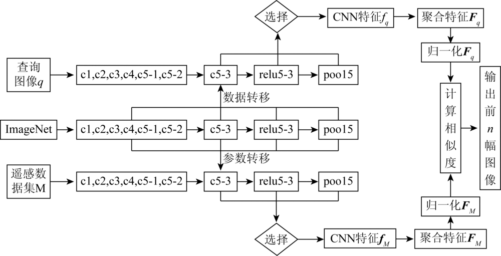
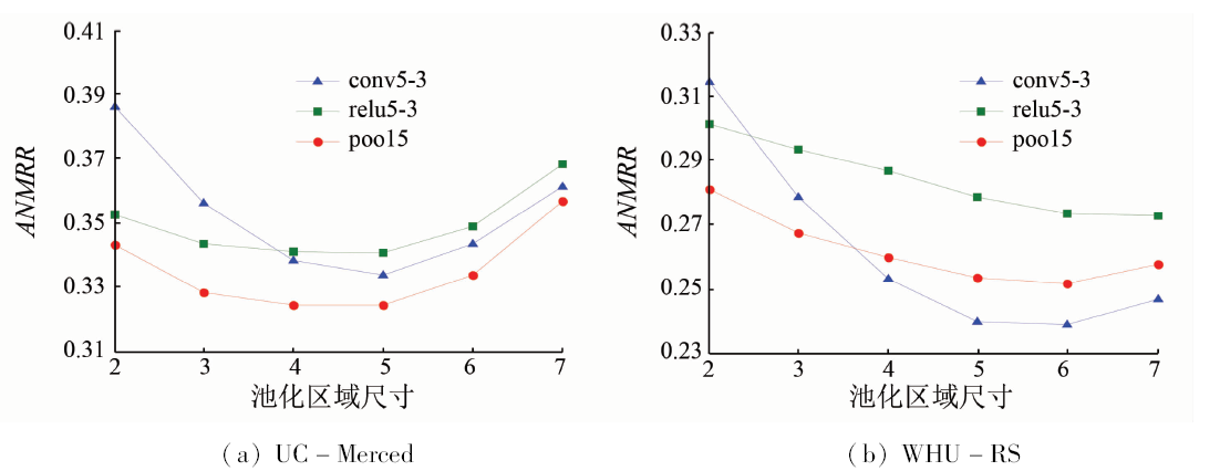
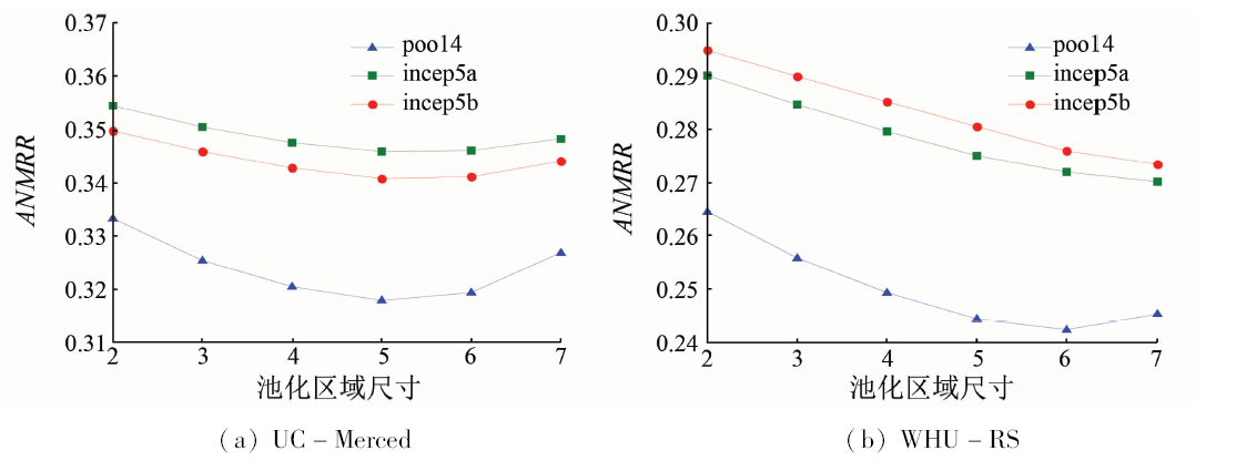
Abstract  

In the high-resolution remote sensing image retrieval, it is difficult for hand-crafted features to describe the images accurately. Thus a method based on aggregating convolutional neural network(CNN) features is proposed to improve the feature representation. First, the parameters from CNN pre-trained on large-scale datasets are transferred for remote sensing images. Given input images with different sizes, the CNN features which represent local information are extracted. Then, average pooling with different pooling region sizes and bag of visual words (BoVW) are adopted to aggregate the CNN features. Pooling features and BoVW features are obtained accordingly. Finally, the above two aggregation features are utilized for remote sensing image retrieval. Experimental results demonstrate that the input image with reasonable size is capable of improving the feature representation. When the pooling region size is between 60% and 80% of the feature map, the vast majority of the results of pooling features are superior to those of the traditional average pooling method. The optimal average normalized modified retrieval rank values of pooling feature and BoVW feature are 27.31% and 21.51% lower than those of hand-crafted feature. Therefore, both the average pooling and BoVW can improve the remote sensing image retrieval performance efficiently.

Keywords remote sensing image      retrieval      convolutional neural network      average pooling      bag of visual words     
:  TP79TP183  
Corresponding Authors: Famao YE     E-mail: yefamao@ncu.edu.cn
Issue Date: 15 March 2019
Service
E-mail this article
E-mail Alert
RSS
Articles by authors
Yun GE
Shunliang JIANG
Famao YE
Changlong JIANG
Ying CHEN
Yiling TANG
Cite this article:   
Yun GE,Shunliang JIANG,Famao YE, et al. Aggregating CNN features for remote sensing image retrieval[J]. Remote Sensing for Land & Resources, 2019, 31(1): 49-57.
URL:  
https://www.gtzyyg.com/EN/10.6046/gtzyyg.2019.01.07     OR     https://www.gtzyyg.com/EN/Y2019/V31/I1/49
输入图像 conv5-3 relu5-3 pool5
224×224×3 14×14×512 14×14×512 7×7×512
256×256×3 16×16×512 16×16×512 8×8×512
600×600×3 38×38×512 38×38×512 19×19×512
Tab.1  Outputs of VGG16 under different input image sizes
输入图像 pool4 incep5a incep5b
224×224×3 7×7×832 7×7×832 7×7×1 024
256×256×3 8×8×832 8×8×832 8×8×1 024
600×600×3 18×18×832 18×18×832 18×18×1 024
Tab.2  Outputs of GoogLeNet under different input image sizes
Fig.1  Retrieval flow chart of VGG16
Tab.3  Sample images of UC-Merced and WHU-RS
Fig.2  ANMRR with different pooling region sizes in VGG16
Fig.3  ANMRR with different pooling region sizes in GoogLeNet
CNN 默认尺寸(224×224) 原始尺寸(256×256)
VGG16 conv5-3 relu5-3 pool5 conv5-3 relu5-3 pool5
尺寸 ANMRR 尺寸 ANMRR 尺寸 ANMRR 尺寸 ANMRR 尺寸 ANMRR 尺寸 ANMRR
9×9 0.334 1 9×9 0.340 4 *4×4 0.324 3 11×11 0.341 8 10×10 0.342 0 4×4 0.327 6
10×10 0.333 7 10×10 0.340 8 5×5 0.324 5 12×12 0.343 0 11×11 0.342 4 5×5 0.326 2
14×14 0.361 4 14×14 0.368 2 7×7 0.356 7 16×16 0.369 3 16×16 0.369 9 8×8 0.358 9
GoogLeNet pool4 incep5a incep5b pool4 incep5a incep5b
尺寸 ANMRR 尺寸 ANMRR 尺寸 ANMRR 尺寸 ANMRR 尺寸 ANMRR 尺寸 ANMRR
*5×5 0.317 9 5×5 0.346 0 5×5 0.340 9 5×5 0.324 4 5×5 0.354 7 6×6 0.343 8
6×6 0.319 5 6×6 0.346 1 6×6 0.341 2 6×6 0.323 5 6×6 0.354 1 7×7 0.345 1
7×7 0.326 9 7×7 0.348 4 7×7 0.344 1 8×8 0.337 5 8×8 0.359 6 8×8 0.349 3
Tab.4  ANMRR with different pooling features on the UC-Merced
CNN 默认尺寸(224×224) 原始尺寸(600×600)
VGG16 conv5-3 relu5-3 pool5 conv5-3 relu5-3 pool5
尺寸 ANMRR 尺寸 ANMRR 尺寸 ANMRR 尺寸 ANMRR 尺寸 ANMRR 尺寸 ANMRR
10×10 0.240 0 12×12 0.273 6 5×5 0.253 5 30×30 0.237 5 28×28 0.243 1 *14×14 0.226 2
11×11 0.237 9 13×13 0.273 1 6×6 0.251 8 31×31 0.237 5 29×29 0.242 9 15×15 0.226 5
14×14 0.246 8 14×14 0.272 8 7×7 0.257 6 38×38 0.251 7 38×38 0.251 6 18×18 0.238 5
GoogLeNet pool4 incep5a incep5b pool4 incep5a incep5b
尺寸 ANMRR 尺寸 ANMRR 尺寸 ANMRR 尺寸 ANMRR 尺寸 ANMRR 尺寸 ANMRR
5×5 0.244 4 5×5 0.275 1 5×5 0.280 5 *14×14 0.232 1 16×16 0.262 5 16×16 0.250 9
6×6 0.242 5 6×6 0.272 0 6×6 0.276 0 15×15 0.232 3 17×17 0.262 8 17×17 0.250 6
7×7 0.245 3 7×7 0.270 1 7×7 0.273 4 18×18 0.241 5 18×18 0.263 4 18×18 0.251 0
Tab.5  ANMRR with different pooling features on the WHU-RS
CNN 默认尺寸 (224×224) 原始尺寸 (256×256)
VGG16 K conv5-3 relu5-3 pool5 conv5-3 relu5-3 pool5
100 0.408 5 0.469 9 0.424 9 0.425 7 0.480 9 0.444 7
150 *0.388 6 0.482 7 0.523 9 0.412 2 0.491 3 0.530 1
1 500 0.410 5 0.474 8 0.482 1 0.414 5 0.477 2 0.475 2
2 000 0.417 5 0.476 0 0.491 8 0.421 5 0.473 8 0.483 7
4 000 0.432 1 0.478 1 0.508 6 0.436 5 0.480 0 0.497 7
GoogLeNet K pool4 incep5a incep5b pool4 incep5a incep5b
100 0.408 6 *0.375 9 0.402 3 0.400 5 0.394 5 0.397 5
150 0.419 6 0.397 3 0.422 0 0.430 8 0.415 6 0.414 0
1 500 0.536 7 0.535 4 0.480 3 0.541 4 0.532 7 0.480 1
2 000 0.581 1 0.551 9 0.492 8 0.559 2 0.550 5 0.491 4
4 000 0.613 8 0.616 9 0.535 3 0.616 1 0.609 8 0.540 6
Tab.6  ANMRR with different BoVW features on the UC-Merced
CNN 默认尺寸 (224×224) 原始尺寸 (600×600)
VGG16 K conv5-3 relu5-3 pool5 conv5-3 relu5-3 pool5
100 0.280 7 0.441 7 0.352 5 0.354 7 0.424 1 0.366 3
150 *0.249 1 0.414 2 0.370 1 0.323 9 0.462 0 0.370 7
1 500 0.275 2 0.411 2 0.391 8 0.268 2 0.356 6 0.355 7
2 000 0.279 6 0.431 6 0.408 6 0.270 5 0.367 6 0.352 2
4 000 0.311 5 0.425 4 0.440 1 0.278 7 0.350 8 0.344 5
GoogLeNet K pool4 incep5a incep5b pool4 incep5a incep5b
100 0.287 7 0.310 5 0.267 4 0.263 1 0.262 1 0.228 2
150 0.298 7 0.311 6 0.286 4 0.226 8 0.259 6 *0.214 9
1 500 0.440 4 0.449 4 0.425 7 0.278 8 0.304 2 0.258 7
2 000 0.469 5 0.488 8 0.423 7 0.289 4 0.309 0 0.262 1
4 000 0.653 8 0.656 0 0.491 4 0.309 5 0.337 0 0.283 6
Tab.7  ANMRR with different BoVW features on the WHU-RS
Fig.4  Precision-recall curves for different features
特征 ANMRR 维度
浅层特征 Aptoula [3] 0.575 0 62
BoVW [5] 0.591 0 15 000
BoVW [5] 0.601 0 150
LSL [6] 0.555 6 2 048
CNN特征 VGGM-fc [12] 0.378 0 4 096
VGGM-fc-RF [12] 0.316 0 4 096
VGG16-fc [13] 0.394 0 4 096
VGGM-conv5-IFK [13] 0.458 0 102
VGG16-conv5-IFK [13] 0.407 0 102
LDCNN [13] 0.439 0 30
GoogLeNet(FT)+MultiPatch[14] 0.314 0 1 024
VGG16-P 0.324 3 8 192
GoogLeNet-P 0.317 9 7 488
VGG16-B 0.388 6 150
GoogLeNet-B 0.375 9 100
Tab.8  ANMRR and dimensions for different features
[1] 朱佳丽, 李士进, 万定生 , 等. 基于特征选择和半监督学习的遥感图像检索[J]. 中国图象图形学报, 2011,16(8):1474-1482.
doi: 10.11834/jig.20110808 url: http://www.cnki.com.cn/Article/CJFDTotal-ZGTB201108019.htm
[1] Zhu J L, Li S J, Wan D S , et al. Content-based remote sensing image retrieval based on feature selection and semi-supervised learning[J]. Journal of Image and Graphics, 2011,16(8):1474-1482.
[2] Demir B, Bruzzone L . A novel active learning method in relevance feedback for content-based remote sensing image retrieval[J]. IEEE Transactions on Geoscience and Remote Sensing, 2015,53(5):2323-2334.
doi: 10.1109/TGRS.2014.2358804 url: http://ieeexplore.ieee.org/document/6920022/
[3] Aptoula E . Remote sensing image retrieval with global morphological texture descriptors[J]. IEEE Transactions on Geoscience and Remote Sensing, 2014,52(5):3023-3034.
doi: 10.1109/TGRS.2013.2268736 url: http://ieeexplore.ieee.org/document/6557520/
[4] 陆丽珍, 刘仁义, 刘南 . 一种融合颜色和纹理特征的遥感图像检索方法[J]. 中国图象图形学报, 2004,9(3):328-333.
doi: 10.3969/j.issn.1006-8961.2004.03.013 url: http://www.cqvip.com/qk/90287X/200403/9525218.html
[4] Lu L Z, Liu R Y, Liu N . Remote sensing image retrieval using color and texture fused features[J]. Journal of Image and Graphics, 2004,9(3):328-333.
[5] Yang Y, Newsam S . Geographic image retrieval using local invariant features[J]. IEEE Transactions on Geoscience and Remote Sensing, 2013,51(2):818-832.
doi: 10.1109/TGRS.2012.2205158 url: http://ieeexplore.ieee.org/document/6257473/
[6] Du Z X, Li X L, Lu X Q . Local structure learning in high resolution remote sensing image retrieval[J].Neurocomputing, 2016(207):813-822.
doi: 10.1016/j.neucom.2016.05.061 url: http://www.sciencedirect.com/science/article/pii/S0925231216305148
[7] Babenko A, Slesarev A, Chigorin A, et al. Neural codes for image retrieval [C]//Proceedings of European Conference on Computer Vision.Springer, 2014: 584-599.
[8] Ng J Y, Yang F, Davis L S. Exploiting local features from deep networks for image [C]//Proceedings of IEEE Conference on Computer Vision and Pattern Recognition workshops.IEEE, 2015: 53-61.
[9] Babenko A, Lempitsky V. Aggregating deep convolutional features for image retrieval [C]//Proceedings of IEEE International Conference on Computer Vision.IEEE, 2015: 1269-1277.
[10] 周飞燕, 金林鹏, 董军 . 卷积神经网络研究综述[J]. 计算机学报, 2017,40(6):1229-1251.
doi: 10.11897/SP.J.1016.2017.01229 url: http://www.cnki.com.cn/Article/CJFDTOTAL-JSJX201706001.htm
[10] Zhou F Y, Jin L P, Dong J . Review of convolutional neural network[J]. Chinese Journal of Computers, 2017,40(6):1229-1251.
[11] 张洪群, 刘雪莹, 杨森 , 等. 深度学习的半监督遥感图像检索[J]. 遥感学报, 2017,21(3):406-414.
doi: 10.11834/jrs.20176105 url: http://d.wanfangdata.com.cn/Periodical/ygxb201703008
[11] Zhang H Q, Liu X Y, Yang S , et al. Retrieval of remote sensing images based on semisupervised deep learning[J].Journal of Remote Sensing, 21(3):406-414.
[12] Napoletano P . Visual descriptors for content-based retrieval of remote sensing images[J]. International Journal of Remote Sensing, 2018,39(5):1343-1376.
doi: 10.1080/01431161.2017.1399472 url: https://www.tandfonline.com/doi/full/10.1080/01431161.2017.1399472
[13] Zhou W X, Newsam S, Li C , et al. Learning low dimensional convolutional neural networks for high-resolution remote sensing image retrieval[J]. Remote Sensing, 2017,9(5):489.
doi: 10.3390/rs9050489 url: http://www.mdpi.com/2072-4292/9/5/489
[14] Hu F, Tong X Y, Xia G S, et al. Delving into deep representations for remote sensing image retrieval [C]//Proceedings of IEEE International Conference on Signal Processing.IEEE, 2016: 198-203.
[15] Simonyan K ,Zisserman A.Very deep convolutional networks for large-scale image recognition[EB/OL]..
url: arXiv.https://arxiv.org/pdf/1409. 1556.pdf
[16] Szegedy C, Liu W, Jia Y Q, et al. Going deeper with convolutions [C]//Proceedings of IEEE Conference on Computer Vision and Pattern Recognition.IEEE, 2015: 1-9.
[17] Hu F, Xia G S, Hu J W , et al. Transferring deep convolutional neural networks for the scene classification of high-resolution remote sensing imagery[J]. Remote Sensing, 2015,7(11):14680-14707.
doi: 10.3390/rs71114680 url: http://www.mdpi.com/2072-4292/7/11/14680
[18] Vedaldi A, Lenc K. MatConvNet:convolutional neural networks for MATLAB [C]//Proceedings of 23rd ACM International Conference on Multimedia.ACM, 2015: 689-692.
[1] ZHANG Daming, ZHANG Xueyong, LI Lu, LIU Huayong. Remote sensing image segmentation based on Parzen window density estimation of super-pixels[J]. Remote Sensing for Natural Resources, 2022, 34(1): 53-60.
[2] XUE Bai, WANG Yizhe, LIU Shuhan, YUE Mingyu, WANG Yiying, ZHAO Shihu. Change detection of high-resolution remote sensing images based on Siamese network[J]. Remote Sensing for Natural Resources, 2022, 34(1): 61-66.
[3] REN Chaofeng, PU Yuchi, ZHANG Fuqiang. A method for extracting match pairs of UAV images considering geospatial information[J]. Remote Sensing for Natural Resources, 2022, 34(1): 85-92.
[4] SONG Renbo, ZHU Yuxin, GUO Renjie, ZHAO Pengfei, ZHAO Kexin, ZHU Jie, CHEN Ying. A method for 3D modeling of urban buildings based on multi-source data integration[J]. Remote Sensing for Natural Resources, 2022, 34(1): 93-105.
[5] LIU Zhizhong, SONG Yingxu, YE Runqing. An analysis of rainstorm-induced landslides in northeast Chongqing on August 31, 2014 based on interpretation of remote sensing images[J]. Remote Sensing for Natural Resources, 2021, 33(4): 192-199.
[6] ZHANG Chengye, XING Jianghe, LI Jun, SANG Xiao. Recognition of the spatial scopes of tailing ponds based on U-Net and GF-6 images[J]. Remote Sensing for Natural Resources, 2021, 33(4): 252-257.
[7] YU Xinli, SONG Yan, YANG Miao, HUANG Lei, ZHANG Yanjie. Multi-model and multi-scale scene recognition of shipbuilding enterprises based on convolutional neural network with spatial constraints[J]. Remote Sensing for Natural Resources, 2021, 33(4): 72-81.
[8] LI Yikun, YANG Yang, YANG Shuwen, WANG Zihao. A change vector analysis in posterior probability space combined with fuzzy C-means clustering and a Bayesian network[J]. Remote Sensing for Natural Resources, 2021, 33(4): 82-88.
[9] SANG Xiao, ZHANG Chengye, LI Jun, ZHU Shoujie, XING Jianghe, WANG Jinyang, WANG Xingjuan, LI Jiayao, YANG Ying. Application of intensity analysis theory in the land use change in Yijin Holo Banner under the background of coal mining[J]. Remote Sensing for Natural Resources, 2021, 33(3): 148-155.
[10] WANG Yiuzhu, HUANG Liang, CHEN Pengdi, LI Wenguo, YU Xiaona. Change detection of remote sensing images based on the fusion of co-saliency difference images[J]. Remote Sensing for Natural Resources, 2021, 33(3): 89-96.
[11] LIU Wanjun, GAO Jiankang, QU Haicheng, JIANG Wentao. Ship detection based on multi-scale feature enhancement of remote sensing images[J]. Remote Sensing for Natural Resources, 2021, 33(3): 97-106.
[12] LU Qi, QIN Jun, YAO Xuedong, WU Yanlan, ZHU Haochen. Buildings extraction of GF-2 remote sensing image based on multi-layer perception network[J]. Remote Sensing for Land & Resources, 2021, 33(2): 75-84.
[13] QIU Yifan, CHAI Dengfeng. A deep learning method for Landsat image cloud detection without manually labeled data[J]. Remote Sensing for Land & Resources, 2021, 33(1): 102-107.
[14] HU Suliyang, LI Hui, GU Yansheng, HUANG Xianyu, ZHANG Zhiqi, WANG Yingchun. An analysis of land use changes and driving forces of Dajiuhu wetland in Shennongjia based on high resolution remote sensing images: Constraints from the multi-source and long-term remote sensing information[J]. Remote Sensing for Land & Resources, 2021, 33(1): 221-230.
[15] FAN Jiazhi, LUO Yu, TAN Shiqi, MA Wen, ZHANG Honghao, LIU Fulai. Accuracy evaluation of the FY-3C/MWRI land surface temperature product in Hunan Province[J]. Remote Sensing for Land & Resources, 2021, 33(1): 249-255.
Viewed
Full text


Abstract

Cited

  Shared   
  Discussed   
京ICP备05055290号-2
Copyright © 2017 Remote Sensing for Natural Resources
Support by Beijing Magtech