|
|
|
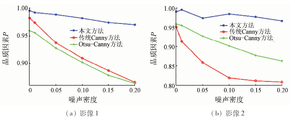
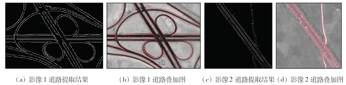
Abstract The extraction method based on the edge features is widely used in the road recognition of remote sensing image. However, the traditional methods are not good at eliminating noise, and tend to cause the misjudgment and leak-judgment of the edge. Therefore, based on the idea of the canny edge detection algorithm, the authors firstly adopt a smoothing and self-adapting Gaussian filter to reduce the noise of remote sensing image, reduce the noise interference and reserve the edge and details. Then, in the edge judgment of the dual threshold, the authors select the high and low thresholds on the basis of local characteristics within the object scale of the pixel point and enhance the exact judgment performance of the edge. The experiment results show that the new method can effectively improve the accuracy and positioning accuracy of the edge detection, obviously reduce the misjudgment of road edge extraction and remarkably increase integrity and consecutiveness, with high automation.
|
| Keywords
remote sensing images
road edge
Canny algorithm
Gauss filter
adaptive
dual threshold
|
|
|
|
Corresponding Authors:
Huixian HUANG
E-mail: huanghx@xtu.edu.cn
|
|
Issue Date: 15 March 2019
|
|
|
| [1] |
胡华龙, 吴冰, 黄邵美 . 结合Gabor纹理与几何特征的高分辨率遥感影像城区道路提取方法[J]. 测绘科学技术学报, 2015,32(4):395-400.
doi: 10.3969/j.issn.1673-6338.2015.04.014
url: http://www.cqvip.com/QK/98086A/201504/666223358.html
|
| [1] |
Hu H L, Wu B, Huang S M . Urban road extraction of high resolution remotely sensed imagery with Gabor texture and geometrical features[J]. Journal of Geomatics Science and Technology, 2015,32(4):395-400.
|
| [2] |
苏腾飞, 李洪玉, 屈忠义 . 高分辨率遥感图像道路分割算法[J]. 国土资源遥感, 2015,27(3):1-6.doi: 10.6046/gtzyyg.2015.03.01.
doi: 10.6046/gtzyyg.2015.03.01
url: http://www.cnki.com.cn/Article/CJFDTotal-GTYG201503001.htm
|
| [2] |
Su T F, Li H Y, Qu Z Y . A study of road segmentation from the high resolution remote sensing image[J]. Remote Sensing for Land and Resources, 2015,27(3):1-6.doi: 10.6046/gtzyyg.2015.03.01.
|
| [3] |
刘晓君, 韩芳, 赵磊 . 一种改进的SAR影像边缘检测方法[J].测绘通报, 2017(9):56-59.
url: http://www.cqvip.com/QK/93318X/201709/673327204.html
|
| [3] |
Liu X J, Han F, Zhao L . An improved edge detection algorithm for SAR images[J].Bulletin of Surveying and Mapping, 2017(9):56-59.
|
| [4] |
陈光, 陈良超, 何兴富 , 等. 一种高分影像城区主干道半自动提取方法[J]. 遥感信息, 2017,32(3):109-114.
doi: 10.3969/j.issn.1000-3177.2017.03.018
url: http://www.cnki.com.cn/Article/CJFDTOTAL-YGXX201703018.htm
|
| [4] |
Chen G, Chen L C, He X F , et al. A semiautomatic extraction method for main-road in high resolution imagery[J]. Remote Sensing Information, 2017,32(3):109-114.
|
| [5] |
谭媛, 黄辉先, 徐建闽 , 等. 基于改进Sobel算子的遥感图像道路边缘检测方法[J]. 国土资源遥感, 2016,28(3):7-11.doi: 10.6046/gtzyyg.2016.03.02.
doi: 10.6046/gtzyyg.2016.03.02
url: http://www.cqvip.com/QK/91397X/201603/669995275.html
|
| [5] |
Tan Y, Huang H X, Xu J M , et al. Road edge detection from remote sensing image based on improved Sobel operator[J]. Remote Sensing for Land and Resources, 2016,28(3):7-11.doi: 10.6046/gtzyyg.2016.03.02.
|
| [6] |
Canny J . A computational approach to edge detection[J]. IEEE Transactions on Pattern Analysis and Machine Intelligence, 1986,8(6):679-698.
doi: 10.1109/TPAMI.1986.4767851
url: http://dl.acm.org/citation.cfm?id=11274.11275
|
| [7] |
Saha P K, Udupa J K, Odhner D . Scale-based fuzzy connected image segmentation:Theory,algorithms, and validation[J]. Computer Vision and Image Understanding, 2000,77(2):145-174.
doi: 10.1006/cviu.1999.0813
url: http://linkinghub.elsevier.com/retrieve/pii/S1077314299908135
|
| [8] |
Chen K . Adaptive smoothing via contextual and local discontinuities.[J]. IEEE Transactions on Pattern Analysis and Machine Intelligence, 2005,27(10):1552-1567.
doi: 10.1109/TPAMI.2005.190
pmid: 16237991
url: http://ieeexplore.ieee.org/document/1498751/
|
| [9] |
钱晓亮, 郭雷, 余博 . 基于目标尺度的自适应高斯滤波[J]. 计算机工程与应用, 2010,46(12):14-16,20.
doi: 10.3778/j.issn.1002-8331.2010.12.004
url: http://www.cnki.com.cn/Article/CJFDTotal-JSGG201012005.htm
|
| [9] |
Qian X L, Guo L, Yu B . Adaptive Gaussian filter based on object scale[J]. Computer Engineering and Applications, 2010,46(12):14-16,20.
|
| [10] |
韦玉春, 汤国安, 汪闽 . 遥感数字图像处理教程[M]. 北京: 科学出版社, 2015.
|
| [10] |
Wei Y C, Tang G A, Wang M. Remote Sensing Digital Image Processing Tutorial[M]. Beijing: China Science Press, 2015.
|
| [11] |
Gonzalez R C, Woods R E, Eddins S L, 等. 数字图像处理(MATLAB版)[M]. 2版.北京: 电子工业出版社, 2013.
|
| [11] |
Gonzalez R C, Woods R E. Digital Image Processing Using MATLAB[M].2nd ed. Beijing: Electronics Industry Press, 2013.
|
| [12] |
Abdou I E, Pratt W K . Quantitative design and evaluation of enhancement/thresholding edge detectors[J]. Proceedings of the IEEE, 1979,67(5):753-763.
doi: 10.1109/PROC.1979.11325
url: http://ieeexplore.ieee.org/document/1455594/
|
| [13] |
秦彦光 . 高分辨率遥感图像道路网及车辆信息提取[D]. 长春:吉林大学, 2014.
|
| [13] |
Qin Y G . Study on Road Network and Automobile Information Extraction Based on High Resolution Remote Sensing Image[D]. Changchun:Jilin University, 2014.
|
|
Viewed |
|
|
|
Full text
|
|
|
|
|
Abstract
|
|
|
|
|
Cited |
|
|
|
|
| |
Shared |
|
|
|
|
| |
Discussed |
|
|
|
|
 2019,
Vol. 31
2019,
Vol. 31
 ), Jianmin XU2, Jiating LIU1