|
|
 |
|

|
|
|
Research on the macro-characteristics of the sedimentation in the middle reach of Chaobai River based on remote sensing |
| Jing ZHANG1, Dongli JI2, Yaonan BAI1, Jinjie MIAO1, Xu GUO1, Dong DU1, Yandong PEI1 |
1.Tianjin Centre, China Geological Survey, Tianjin 300170, China
2.School of Environmental and Municipal Engineering, Tianjin Urban Construction College, Tianjin 300384, China |
|
|
|
|
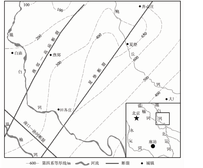
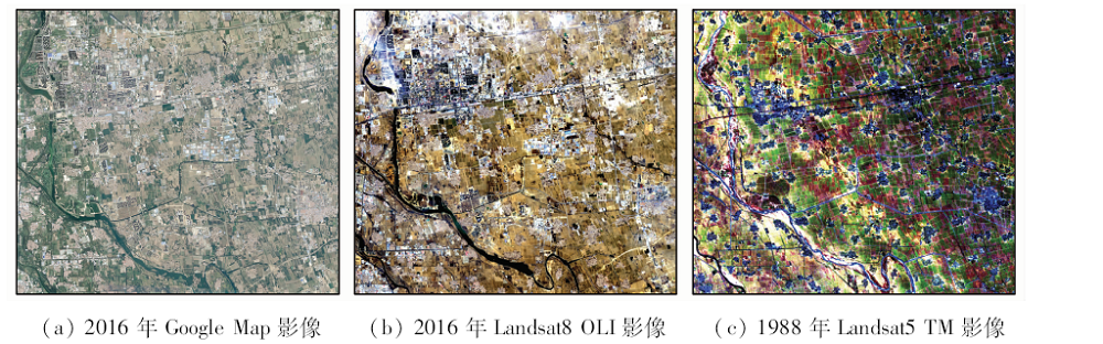
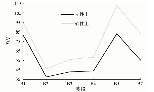
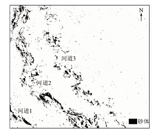
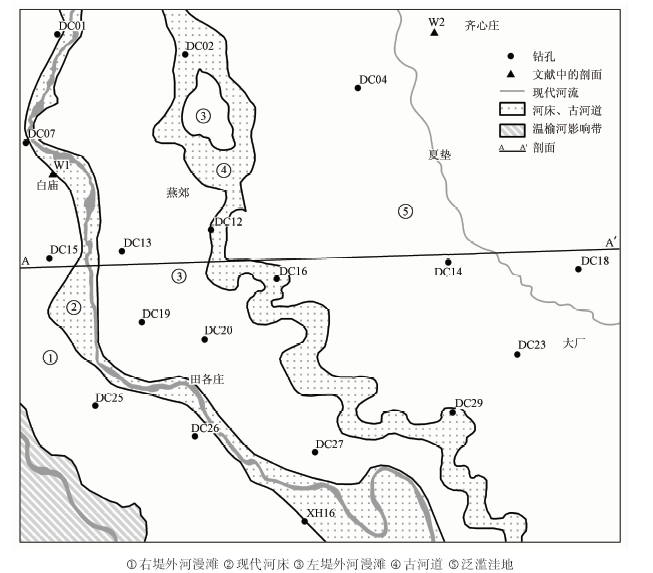
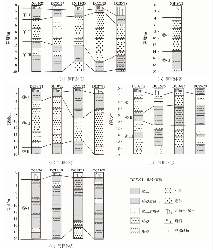
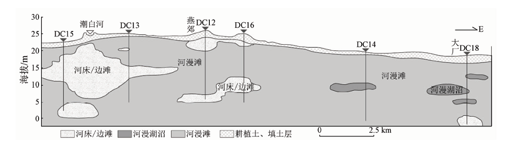
Abstract According to the reflectance spectroscopy of remote sensing (RS) data of field sandy soil and cohesive soil, the shallow sedimentary framework in the middle reach of Chaobai River (MRCR) was interpreted and proved by sediment cores. Considering regional and vertical variation, the authors investigated the macro-characteristics of the sedimentation in the MRCR. The results show that early mid-low spatial resolution Landsat TM data are effective in identifying sandy soil and cohesive soil, and the two kinds of soil have obviously different colors in B7(R), B4(G)and B1(B), and the change of grain size can be reflected by color saturation. The shallow sediment cores are in good agreement with RS interpretation. Finally, the shallow deposits can be divided into five parts: the left floodplain, the recent riverbed, the right floodplain, the paleo-river and the flood lowland. Among them, paleo-rivers are developed in shallow layer as lenses, while the other parts exhibit inherited development at the depth of 20 m and shift with the river swinging.
|
| Keywords
Chaobai River
remote sensing
Landsat TM
sedimentation
borehole
|
|
|
|
Issue Date: 14 March 2019
|
|
|
| [1] |
尤联元 . 潮白河流域古侵蚀环境[J]. 泥沙研究, 1985(4):12-21.
url: http://www.cnki.com.cn/Article/CJFDTotal-NSYJ198504002.htm
|
| [1] |
You L Y . A study on the paleoerosion environment of the Chaobaihe River Basin[J]. Journal of Sediment Research, 1985(4):12-21.
|
| [2] |
刘记来, 庞忠和, 王素芬 , 等. 近30年来降水量变化和人类活动对北京潮白河冲洪积扇地下水动态的影响[J]. 第四纪研究, 2010,30(1):138-144.
doi: 10.3969/j.issn.1001-7410.2010.01.13
url: http://d.wanfangdata.com.cn/Periodical/dsjyj201001013
|
| [2] |
Liu J L, Pang Z H, Wang S F , et al. Impact of precipitation change and human activities on groundwater regime in the Chaobaihe alluvialand diluvial fan in Beijing in the last 30 years[J]. Quaternary Sciences, 2010,30(1):138-144.
|
| [3] |
郭岭, 姜在兴, 徐杰 . 现代潮白河岩相与沉积相特征[J]. 岩性油气藏, 2011,23(1):57-61.
doi: 10.3969/j.issn.1673-8926.2011.01.010
|
| [3] |
Guo L, Jiang Z X, Xu J . Sedimentary facies and lithofacies characteristics of modern Chaobai River[J]. Lithologic Reservoirs, 2011,23(1):57-61.
|
| [4] |
吴忱 . 华北地貌环境及其形成演化[M]. 北京: 科学出版社, 2008: 79-81.
|
| [4] |
Wu C. Landform Environment and Its Formation in North China[M]. Beijing: Science Press, 2008: 79-81.
|
| [5] |
吴忱 . 华北平原古河道研究[M]. 北京: 中国科学技术出版社, 1991: 2-4.
|
| [5] |
Wu C. A Study of Ancient Channels on North China Plain[M]. Beijing: Science and Technology of China Pres, 1991: 2-4.
|
| [6] |
刘智荣, 沈军, 黄静宜 , 等. 河北三河晚更新世地层粒度特征分析[J]. 地质学报, 2016,90(5):997-1005.
|
| [6] |
Liu Z R, Shen J, Huang J Y , et al. Grain size analysis of the Late Pleistocene sediments in Sanhe County,Hebei Province[J]. Acta Geologica Sinica, 2016,90(5):997-1005.
|
| [7] |
郭峰, 郭岭, 姜在兴 , 等. 潮白河现代沉积特征与沉积模式[J]. 大庆石油学院学报, 2010,34(2):7-10.
doi: 10.3969/j.issn.2095-4107.2010.02.002
url: http://www.cqvip.com/Main/Detail.aspx?id=33798923
|
| [7] |
Guo F, Guo L, Jiang Z X , et al. Sedimentary characteristics and depositional model of modern Chaobai River[J]. Journal of Daqing Petroleum Institute, 2010,34(2):7-10.
|
| [8] |
Legleiter C J, Stegman T K, Overstreet B T . Spectrally based mapping of riverbed composition[J]. Geomorphology, 2016,264:61-79.
doi: 10.1016/j.geomorph.2016.04.006
url: https://linkinghub.elsevier.com/retrieve/pii/S0169555X16301660
|
| [9] |
Rainey M P, Tyler A N, Gilvear D J , et al. Mapping intertidal estuarine sediment grain size distributions through airborne remote sensing[J]. Remote Sensing of Environment, 2003,86(4):480-490.
doi: 10.1016/S0034-4257(03)00126-3
url: http://linkinghub.elsevier.com/retrieve/pii/S0034425703001263
|
| [10] |
Thunell R, Pride C, Tappa E, et al. Varve formation in the Gulf of California:Insights from time series sediment trap sampling and remote sensing[J]. Quaternary Science Reviews, 1993,12(6):451-464.
doi: 10.1016/S0277-3791(05)80009-5
url: https://linkinghub.elsevier.com/retrieve/pii/S0277379105800095
|
| [11] |
濮静娟 . 应用遥感图象研究河床演变[J]. 地理科学, 1984,4(3):235-242,293.
url: http://www.cnki.com.cn/Article/CJFDTotal-DLKX198403005.htm
|
| [11] |
Pu J J . An application of remote sensing imagery to the investigation of river channel changes[J]. Scientia Geographica Sinica, 1984,4(3):235-242,293.
|
| [12] |
孙仲明 . 历史时期水系变迁的遥感分析方法[J]. 地域研究与开发, 1984(1):1-12.
url: http://www.cnki.com.cn/Article/CJFDTotal-DYYY198401000.htm
|
| [12] |
Sun Z M . Remote sensing analysis method of river system changes in historical period[J]. Areal Research and Development, 1984(1):1-12.
|
| [13] |
王燕飞 . 最近40年来丁字湾潮滩表层沉积特征演变的遥感定量反演[D]. 烟台:鲁东大学, 2013.
|
| [13] |
Wang Y F . Quantitative Remote Sensing Inversion of Characteristics of Surface Sediment on the Intertidal Flat of Dingzi Bay in the Last 40 Years[D]. Yantai:Ludong University, 2013.
|
| [14] |
马世忠, 张永清 . 应用遥感信息图像研究现代水下分流河道河流类型[J]. 地学前缘, 2012,19(2):24-31.
url: http://d.wanfangdata.com.cn/Periodical/dxqy201202005
|
| [14] |
Ma S Z, Zhang Y Q . Research on the channel pattern of present subaqueous distributary channel by remote sensing image[J]. Earth Science Frontiers, 2012,19(2):24-31.
|
| [15] |
张福堂 . 永定河冲积扇及古河道在卫星图象上的显示特征[J]. 水文地质工程地质, 1986(1):53-54.
url: http://www.cnki.com.cn/Article/CJFDTotal-SWDG198601019.htm
|
| [15] |
Zhang F T . The display features of the alluvial fan and the ancient channel in the Yongding River on remote sensing images[J]. Hydrogeology and Engineering Geology, 1986(1):53-54.
|
| [16] |
濮静娟 . 遥感遥测资料在河床演变研究方面的应用[J]. 泥沙研究, 1982(3):25-32.
url: http://www.cnki.com.cn/Article/CJFDTotal-NSYJ198203002.htm
|
| [16] |
Pu J J . Application of remote sensing in the investigations of river channel changes[J]. Journal of Sediment Research, 1982(3):25-32.
|
| [17] |
安国英 . 遥感技术在新生代水文地质调查中的应用:以喀喇昆仑山温泉幅1:25万区域水文地质调查为例[J]. 现代地质, 2013,27(6):1445-1453.
doi: 10.3969/j.issn.1000-8527.2013.06.024
url: http://d.wanfangdata.com.cn/Periodical_xddz201306024.aspx
|
| [17] |
An G Y . Application of satellite remote sensing in regional hydrogeological investigation:Taking Cenozoic Strata in wenquan sheet (1:250000) of Karakoram range as an example[J]. Geoscience, 2013,27(6):1445-1453.
|
| [18] |
田优平, 余达远, 万永革 , 等. 三河—平谷地震区地球物理特征研究[J]. 地球物理学进展, 2014,29(4):1563-1572.
doi: 10.6038/pg20140410
url: http://www.cqvip.com/QK/98047X/201404/663621642.html
|
| [18] |
Tian Y P, Yu D Y, Wan Y G , et al. Research on the geophysical characteristics of Sanhe-Pinggu earthquake region[J].Progress in Geophysics (in Chinese), 29(4):1563-1572
|
| [19] |
姜在兴 . 沉积学[M]. 北京: 石油工业出版社, 2003: 282-291.
|
| [19] |
Jiang Z X. Sedimentology[M]. Beijing: Petroleum Industry Press, 2003: 282-291.
|
| [20] |
胡镜荣, 石凤英 . 华北平原古河道发育的环境条件及其沉积特征[J]. 地理研究, 1983,2(4):48-59.
doi: 10.11821/yj1983040006
url: http://www.cnki.com.cn/Article/CJFDTotal-DLYJ198304005.htm
|
| [20] |
Hu J R, Shi F Y . The environmental conditions of the development of paleoghannels in the Hua Bei(North China) Plain and their sedimental characteristics[J]. Geographical Research, 1983,2(4):48-59.
|
| [21] |
Sobrino J A , Jiménez-Muñoz J C,Paolini L.Land surface temperature retrieval from LANDSAT TM 5[J]. Remote Sensing of Environment, 2004,90(4):434-440.
doi: 10.1016/j.rse.2004.02.003
url: https://linkinghub.elsevier.com/retrieve/pii/S0034425704000574
|
| [22] |
梅安新, 彭望琭, 秦其明 , 等. 遥感导论[M]. 北京: 高等教育出版社, 2001: 225-228.
|
| [22] |
Mei A X, Peng W L, Qin Q M , et al. An Introduction to Remote Sensing[M]. Beijing: Higher Education Press, 2001: 225-228.
|
| [23] |
成都地质学院陕北队. 沉积岩(物)粒度分析及其应用[M]. 北京: 地质出版社, 1978: 44-53.
|
| [23] |
Northern Shaanxi team of Chengdu College of Geology. Grain Size Analysis of Sediment and Its Application[M]. Beijing: The Geological Publishing House, 1978: 44-53.
|
| [24] |
张凌华, 张振克 . 河漫滩沉积与环境研究进展[J]. 海洋地质与第四纪地质, 2015,35(5):153-163.
url: http://www.cqvip.com/QK/96122X/201505/666617617.html
|
| [24] |
Zhang L H, Zhang Z K . Research progress of river overbank deposits and implications for environment[J]. Marine Geology and Quaternary Geology, 2015,35(5):153-163.
|
| [25] |
黄操明, 周安朝, 王丽清 . 试论含煤盆地构造的继承性及砂体对煤灰分的控制[J]. 沉积学报, 1995,13(1):102-109.
doi: 10.1088/0256-307X/12/7/010
url: http://www.cqvip.com/Main/Detail.aspx?id=1702628
|
| [25] |
Huang C M, Zhou A C, Wang L Q . A discussion on the structural heredity of coal-bearing basin and sandbody’s control on coal ash composition[J]. Acta Sedimentologica Sinica, 1995,13(1):102-109.
|
| [26] |
吴根耀, 梁兴, 陈方鸿 . 鄂尔多斯断块新生构造的继承性发育及对油气勘探的启示[J]. 现代地质, 2009,23(4):595-606.
doi: 10.3969/j.issn.1000-8527.2009.04.003
url: http://d.wanfangdata.com.cn/Periodical/xddz200904003
|
| [26] |
Wu G Y, Liang X, Chen F H . Inheritance developing of neogenic structures in the Ordos Fault-block and its inspirations for oil-gas exploration[J]. Geoscience, 2009,23(4):595-606.
|
|
Viewed |
|
|
|
Full text
|
|
|
|
|
Abstract
|
|
|
|
|
Cited |
|
|
|
|
| |
Shared |
|
|
|
|
| |
Discussed |
|
|
|
|
 2019,
Vol. 31
2019,
Vol. 31