|
|
 |
|

|
|
|
Potential analysis of typical vegetation index for identifying burned area |
Guifen SUN1, Xianlin QIN1( ), Shuchao LIU1, Xiaotong LI1, Xiaozhong CHEN2, Xiangqing ZHONG2 ), Shuchao LIU1, Xiaotong LI1, Xiaozhong CHEN2, Xiangqing ZHONG2 |
1.Key Laboratory of Forestry Remote Sensing and Information Techniques, State Forestry Administration, Research Institute of Forest Resources Information Technique, Chinese Academy of Forestry, Beijing 100091, China
2.Forestry Information Center of Sichuan Province, Chengdu 610081, China |
|
|
|
|
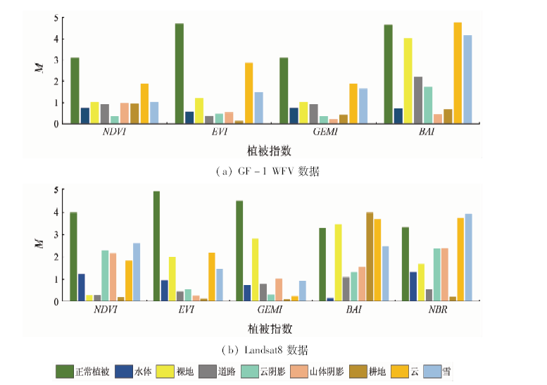
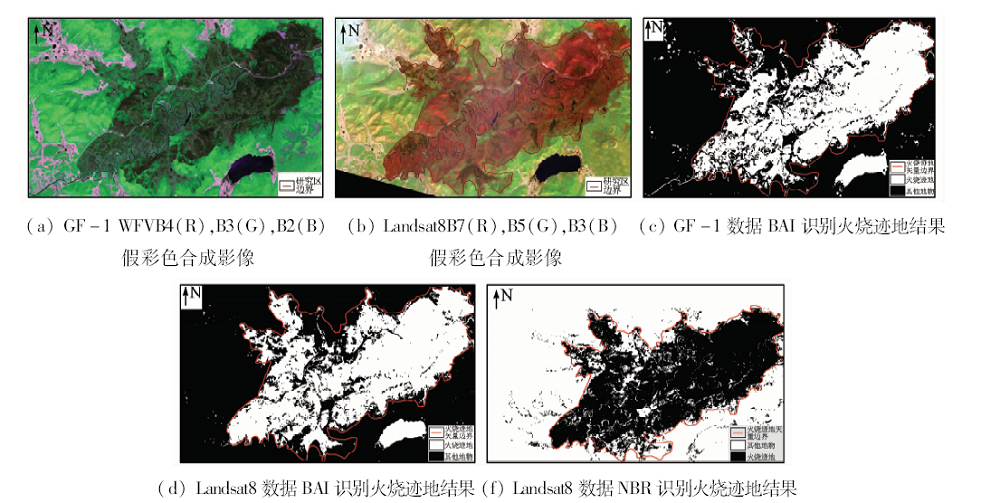
Abstract Vegetation index is one of the commonly used method for adopting satellite remote sensing image to identify burned areas. Due to the disturbance of fire, vegetation becomes burned area, and its spectral characteristics are easily confused with the spectra of bare land, water body, road, shadow and arable land and some other factors. Therefore, the improvement of the accuracy of remote sensing monitoring for burned area using appropriate vegetation index remains an urgent problem. In this paper, four burned areas in Sichuan Province and Inner Mongolia where fire burning occurred in 2014 and 2017 were selected as the study areas. Based on the spectral characteristics of Gaofen-1 satellite 16 m wide width (GF-1 WFV) data and Landsat8 data, the authors chose normalized difference vegetation index (NDVI), enhanced vegetation index (EVI), global environment monitoring index (GEMI), burned area index (BAI) and normalized burn ration (NBR) and constructed separation index M of different spectral indices to quantitatively evaluate the potential of different spectral indices for burned areas identification. The results show that NBR calculated with near-infrared and short-wave infrared band and BAI based on visible light-near infrared band have a better capability for separating burned areas, the separability of NDVI takes the second, whereas EVI and GEMI have a poor separability. For GF-1 WFV data and Landsat8 data, BAI and NBR which have a good separate capability for burned area identification were used for the burned area in Oroqen Autonomous Banner of Inner Mongolia to separate burned areas (for GF-1 WFV data, only BAI was used to identify burned area), and Gaofen-2 satellite (GF-2) data which have higher spatial resolution combined with confusion matrix method were used to verify the accuracy. The overall accuracy of both methods were higher than 87%, and the Kappa coefficients were all higher than 0.7.
|
| Keywords
GF-1 WFV data
Landsat8 data
burned area
vegetation index
separability
|
|
|
|
Corresponding Authors:
Xianlin QIN
E-mail: noaags@ifrit.ac.cn
|
|
Issue Date: 14 March 2019
|
|
|
| [1] |
Dubinin M, Potapov P, Lushchekina A , et al. Reconstructing long time series of burned areas in arid grasslands of southern Russia by satellite remote sensing[J]. Remote Sensing of Environment, 2010,114(8):1638-1648.
doi: 10.1016/j.rse.2010.02.010
url: https://linkinghub.elsevier.com/retrieve/pii/S0034425710000696
|
| [2] |
Key C H . Ecological and sampling constraints on defining landscape fire severity[J]. Fire Ecology, 2006,2(2):34-59.
doi: 10.4996/fireecology.0202034
url: http://www.fireecology.net/JournalMast
|
| [3] |
Roy D P, Jin Y, Lewis P E , et al. Prototyping a global alforithm for systematic fire-affected area mapping using MODIS time series data[J]. Remote Sensing of Environment, 2005,97(2):137-162.
doi: 10.1016/j.rse.2005.04.007
url: https://linkinghub.elsevier.com/retrieve/pii/S0034425705001136
|
| [4] |
Veraverbeke S, Harris S, Hook S . Evaluating spectral indices for burned area discrimination using MODIS/ASTER(MASTER) airborne simulator data[J]. Remote sensing of Environment, 2011,115(10):2702-2709.
doi: 10.1016/j.rse.2011.06.010
url: https://linkinghub.elsevier.com/retrieve/pii/S0034425711002343
|
| [5] |
Carriello F, Anderson L O, Adami M. Multitemporal analysis of the spectral response of scars of burnt area using the Landsat/ETM sensor[C]// IEEE International Geoscience and Remote Sensing Symposium(IGARSS).Barcelona:IEEE, 2007.
|
| [6] |
Chuvieco E, Martín M P, Palacios A . Assessment of different spectral indices in the red-near-infrared spectral domain for burned land discrimination[J]. International Journal of Remote Sensing, 2002,23(23):5103-5110.
doi: 10.1080/01431160210153129
url: https://www.tandfonline.com/doi/full/10.1080/01431160210153129
|
| [7] |
朱曦, 覃先林 . 基于二阶段算法的HJ-CCD数据过火区制图[J]. 遥感技术与应用, 2013,28(1):72-77.
doi: 10.11873/j.issn.1004-0323.2013.1.72
url: http://www.cnki.com.cn/Article/CJFDTotal-YGJS201301011.htm
|
| [7] |
Zhu X, Qin X L . Burned area mapping using HJ-1A/B CCD data based on two-phase algorithm[J]. Remote Sensing Technology and Application, 2013,28(1):72-77.
|
| [8] |
Huete A, Didan K, Miura T , et al. Overview of the radiometric and biophysical performance of the MODIS vegetation indices[J]. Remote Sensing of Environment, 2002,83(1):195-213.
doi: 10.1016/S0034-4257(02)00096-2
url: http://linkinghub.elsevier.com/retrieve/pii/S0034425702000962
|
| [9] |
Pinty B, Verstraete M M . GEMI:A nonlinear index to monitor global vegetation from satellites[J]. Vegetatio, 1992,101(1):15-20.
doi: 10.1007/BF00031911
url: http://link.springer.com/10.1007/BF00031911
|
| [10] |
Loboda T, O’neal K J, Csiszar I . Regionally adaptable dNBR-based algorithm for burned area mapping from MODIS data[J]. Remote Sensing of Environment, 2007,109(4):429-442.
doi: 10.1016/j.rse.2007.01.017
url: https://linkinghub.elsevier.com/retrieve/pii/S0034425707000715
|
| [11] |
López García M J L, Caselles V . Mapping burns and natural reforestation using thematic mapper data[J]. Geocarto International, 1991,6(1):31-37.
doi: 10.1080/10106049109354290
url: http://www.tandfonline.com/doi/abs/10.1080/10106049109354290
|
| [12] |
Bastarrika A, Chuvieco E, Martin M P . Mapping burned areas from Landsat TM/ETM+ data with a two-phase algorithm:Balancing omission and commission errors[J]. Remote Sensing of Environment, 2011,115(4):1003-1012.
doi: 10.1016/j.rse.2010.12.005
url: https://linkinghub.elsevier.com/retrieve/pii/S0034425710003433
|
| [13] |
覃先林 . 林火卫星遥感监测[M]. 北京: 中国林业出版社, 2016: 10-12.
|
| [13] |
Qin X L. Forest Fire Monitoring Using Satellite Remote Sensing[M]. Beijing: China Forestry Publishing House, 2016: 10-12.
|
| [14] |
Wulder M A, White J C, Alvarez F , et al. Characterizing boreal forest wildfire with multi-temporal Landsat and LiDAR data[J]. Remote Sensing of Environment, 2009,113(7):1540-1555.
doi: 10.1016/j.rse.2009.03.004
url: https://linkinghub.elsevier.com/retrieve/pii/S0034425709000844
|
| [15] |
Kennedy R E, Yang Z Q, Cohen W B . Detecting trends in forest disturbance and recovery using yearly Landsat time series:1.LandTrendr-Temporal segmentation algorithms[J]. Remote Sensing of Environment, 2010,114(12):2897-2910.
doi: 10.1016/j.rse.2010.07.008
url: https://linkinghub.elsevier.com/retrieve/pii/S0034425710002245
|
| [16] |
Cohen W B, Yang Z Q, Kennedy R . Detecting trends in forest disturbance and recovery using yearly Landsat time series:2.TimeSync-Tools for calibration and validation[J]. Remote Sensing of Environment, 2010,114(12):2911-2924.
doi: 10.1016/j.rse.2010.07.010
url: https://linkinghub.elsevier.com/retrieve/pii/S0034425710002269
|
| [17] |
Kaufman Y J, Remer L A . Detection of forests using mid-IR reflectance:An application for aerosol studies[J]. IEEE Transactions on Geoscience and Remote Sensing, 1994,32(3):672-683.
doi: 10.1109/36.297984
url: http://ieeexplore.ieee.org/document/297984/
|
| [18] |
Lasaponara R . Estimating spectral separability of satellite derived parameters for burned areas mapping in the Calabria region by using SPOT-Vegetation data[J]. Ecological Modelling, 2006,196(1-2):265-270.
doi: 10.1016/j.ecolmodel.2006.02.025
url: https://linkinghub.elsevier.com/retrieve/pii/S0304380006000676
|
| [19] |
Smith A M S, Drake N A, Wooster M J , et al. Production of Landsat ETM+ reference imagery of burned areas within Southern African savannahs:Comparison of methods and application to MODIS[J]. International Journal of Remote Sensing, 2007,28(12):2753-2775.
doi: 10.1080/01431160600954704
url: https://www.tandfonline.com/doi/full/10.1080/01431160600954704
|
| [20] |
Gitas I Z, Devereux B J . The role of topographic correction in mapping recently burned Mediterranean forest areas from Landsat TM images[J]. International Journal of Remote Sensing, 2006,27(1):41-54.
doi: 10.1080/01431160500182992
url: https://www.tandfonline.com/doi/full/10.1080/01431160500182992
|
|
Viewed |
|
|
|
Full text
|
|
|
|
|
Abstract
|
|
|
|
|
Cited |
|
|
|
|
| |
Shared |
|
|
|
|
| |
Discussed |
|
|
|
|
 2019,
Vol. 31
2019,
Vol. 31