|
|
 |
|

|
|
|
A study of extension of Lianhuashan fault in Guangdong to adjacent marine space based on remote sensing and aeromagnetic data |
| Lingyan XIA1,2, Changsong LIN1, Xiao LI2, Yue HU2 |
1.School of Ocean Sciences, China University of Geosciences, Beijing 100083, China
2.China Aero Geophysical Survey and Remote Sensing Center for Natural Resources, Beijing 100083, China |
|
|
|
|
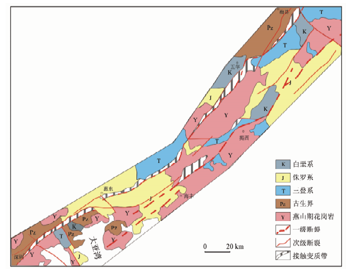
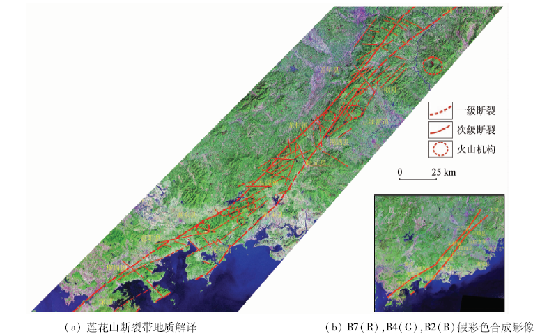
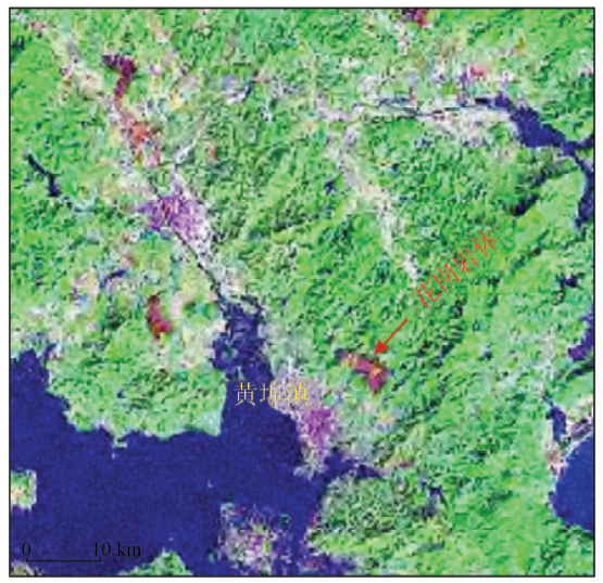
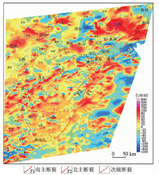
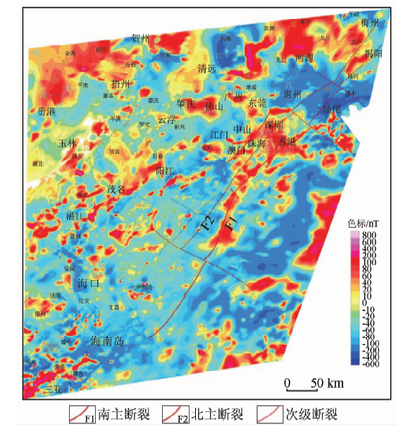
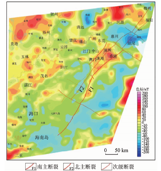
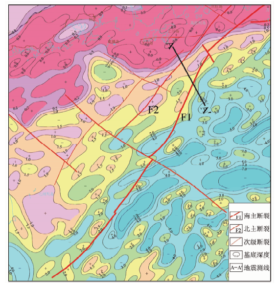
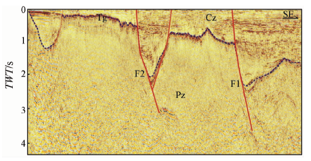
Abstract Studies suggest that Lianhuashan fault has extended to marine space. Based on remote sensing image interpretation using terrestrial ETM+ data and structural characteristics of aeromagnetic deduced faults in marine space, the authors analyzed sedimentary control of the Lianhuashan fault on the Pearl River Mouth Basin. On the one hand, the result of remote sensing interpretation shows that Lianhuashan fault zone presents a NE-trending fascicular linear feature with two branches extending into the sea in SW direction. The main fault belt is a mountain with low hills and plains on both sides characterized by steepness in the east and gentleness in the west. The authors found that the NE-trending straight line river is developed along the fault zone, and the eastern side of mountains develops deep "V" ravines, vertical cliffs or fault triangles. On the other hand, the magnetic field feature reveals that the branch has extended to the north of Pearl River Mouth Basin and the south branch has passed through Pearl River Mouth Basin to the south of Hainan Island. Magmatic activity is developed obviously along the fault belt. The Lianhuashan fault zone is the dividing line of different magnetic fields, which dominate the NEE-trending basement structure of the Pearl River Mouth Basin with deep source magma activity. It is the first stage deep fault in the Pearl River Mouth Basin.
|
| Keywords
remote sensing image
magnetic field
Lianhuashan fault
Pearl River Mouth basin
|
|
|
|
Issue Date: 14 March 2019
|
|
|
| [1] |
刘以宣 . 华南沿海的活动断裂[J]. 海洋地质与第四纪地质, 1985,5(3):11-13.
url: http://www.cnki.com.cn/Article/CJFDTotal-HYDZ198503001.htm
|
| [1] |
Liu Y X . The active fractures in South China Coast[J]. Marine Geology and Quaternary Geology, 1985,5(3):11-13.
|
| [2] |
郭令智, 舒良树, 卢华复 , 等. 中国地体构造研究进展综述[J]. 南京大学学报(自然科学版), 2000,36(1):1-12.
doi: 10.3321/j.issn:0469-5097.2000.01.001
url: http://www.cnki.com.cn/Article/CJFDTotal-NJDZ200001000.htm
|
| [2] |
Guo L Z, Shu L S, Lu F H , et al. A synthetical review on research advances on the terrane tectonics in China[J]. Journal of Nanjing Iniversity(Natrual Sciences), 2000,36(1):1-12.
|
| [3] |
舒良树 . 华南构造演化基本特征[J]. 地质通报, 2012,31(7):1035-1050.
doi: 10.3969/j.issn.1671-2552.2012.07.003
url: http://d.wanfangdata.com.cn/Periodical/zgqydz201207003
|
| [3] |
Shu L S . An analysis of principal features of tectonic evolution in South China Block[J]. Geology Bulletin of China, 2012,31(7):1035-1050.
|
| [4] |
刘以宣, 卓家仑 . 珠江口—红海湾沿海的活动断裂[J]. 热带海洋, 1983,2(3):173-181
url: http://www.cnki.com.cn/Article/CJFDTotal-RDHY198303000.htm
|
| [4] |
Liu Y X, Zhuo J L . The coastal active fracture along Zhujiangkou(Pearl River Mouth)to Honghai (Red Sea)Bay[J]. Tropic Oceanology, 1983,2(3):173-181
|
| [5] |
宋海斌, 郝天珧, 江为为 , 等. 南海地球场特征与基底断裂体系研究[J]. 地球物理学进展, 2002,17(1):24-33.
doi: 10.3969/j.issn.1004-2903.2002.01.003
url: http://www.cnki.com.cn/Article/CJFDTotal-DQWJ200201003.htm
|
| [5] |
Song H B, Hao T Y, Jiang W W , et al. Researches on geophysical field characteristics and basement fault system of South China Sea[J]. Progress in Geophysics, 2002,17(1):24-33.
|
| [6] |
郝天珧, 刘建华, 宋海斌 , 等. 华南及其相邻边缘海域一些重要断裂的地球物理证据[J]. 地球物理学进展, 2002,17(1):13-23.
doi: 10.3969/j.issn.1004-2903.2002.01.002
url: http://d.wanfangdata.com.cn/Periodical/dqwlxjz200201002
|
| [6] |
Hao T Y, Liu J H, Song H B , et al. Geophysical evidences of some important faults in South China and adjacent marginal seas region[J]. Progress in Geophysics. 2002,17(1):13-23.
|
| [7] |
郭令智, 施央申, 马瑞士 . 华南大地构造格架和地壳演化[M]//. 华南板块构造.北京: 地质出版社, 2001: 1-6.
|
| [7] |
Guo L Z, Shi Y S, Ma R S. Tectonic framework and crustal evolution in south China[M]// South China Plate Tectonics. Beijing: Geological Publishing House, 2001: 1-6.
|
| [8] |
张莉, 曾维军, 韦振权 , 等. 南海北部古构造格局对中、新生界发育的影响[J]. 地学前缘, 2014,21(6):254-262.
doi: 10.13745/j.esf.2014.06.025
url: http://www.cnki.com.cn/Article/CJFDTotal-DXQY201406031.htm
|
| [8] |
Zhang L, Zeng W J, Wei Z Q , et al. The impact of northern South China Sea paletectonic framework on development of Mesozoic and Cenzoic[J]. Earth Science Frontiers, 2014,21(6):254-263
|
| [9] |
王霄飞, 余珊, 龚跃华 , 等. 华南北东向断裂在南海北部陆架的延伸[J]. 大地构造与成矿学, 2014,38(3):557-570.
url: http://www.cqvip.com/QK/90781X/201403/662157746.html
|
| [9] |
Wang X F, Yu S, Gong Y H , et al. Extension of NE-trending faults in South China to northern South China Sea continental shelf[J]. Geotectonica et Metallogenia. 2014,38(3):557-570.
|
| [10] |
熊盛青, 李占奎, 丁燕云 , 等. 中国陆域断裂及岩浆岩构造图(1:250万)说明书[M]. 北京: 地质出版社, 2015.
|
| [10] |
Xiong S Q, Li Z K Ding Y Y, , et al. Description of China’s continental fault and magmatic structure (1:250 000) [M]. Beijing: Geological Publishing House, 2015.
|
| [11] |
邱元禧, 邱津松, 李建超 , 等. 广东莲花山断裂带中、新生代多期复合变形变质带的基本特征及其形成机制的探讨[R]. 中国地质科学院地质力学研究所, 1991: 93-105.
|
| [11] |
Qiu Y X, Qiu J S, Li J C , et al. Deformational and Metamorphic Features of Lianhuashan Fault Zone During Meso-Cenozoic Time and Mechanism of Their Formation[R]. Institute of Geomechanics,Chinese Academy of Geological Science, 1991: 93-105.
|
| [12] |
陈定国, 姚梅尹 . 莲花山断裂带南段的地震和构造[J]. 华南地震, 1984,4(1):42-51.
url: http://www.cnki.com.cn/Article/CJFDTotal-HNDI198401003.htm
|
| [12] |
Chen D G, Yao M Y . Earthquakes and structures of the Lianhushan zone in the South[J]. South China Journal of Seismology, 1984,4(1):42-51.
|
| [13] |
齐信, 刘广宁, 黄长生 . 麻城—团风断裂带分段活动特征遥感调查[J]. 国土资源遥感, 2018,30(1):121-127.doi: 10.6046/gtzyyg.2018.01.17.
doi: 10.6046/gtzyyg.2018.01.17
url: http://www.cqvip.com/QK/91397X/201801/674529986.html
|
| [13] |
Qi X, Liu G N, Huang C S . Remote sensing investigation for active characteristics of Macheng-Tuanfeng fault zone segmentation[J]. Remote Sensing for Land and Resources. 2018,30(1):121-127.doi: 10.6046/gtzyyg.2018.01.17.
|
| [14] |
付萍杰, 张景发, 王鑫 . 基于遥感和重力多源数据研究沂沭断裂带南段及周边断裂的交切关系[J]. 地震学报, 2017,39(5):708-724.
doi: 10.11939/jass.2017.05.007
url: http://www.cqvip.com/QK/93548X/201705/68908866504849554853484855.html
|
| [14] |
Fu P J, Zhang J F, Wang X . Intersection relationship between south segment of Yishu fault zone and surrounding faults derived from remote sensing and gravity multisource data[J]. Acta Seismologica Sinica, 2017,39(5):708-724.
|
| [15] |
熊盛青, 李占奎, 丁燕云 , 等. 中国陆域磁场构造及岩浆岩特征[M]. 北京: 地质出版社, 2015: 156-187.
|
| [15] |
Xiong S Q, Li Z K, Ding Y Y , et al. Characteristics of China’s Terrestrial Magnetic Field Structure and Magmatic Rocks[M]. Beijing: Geological Publishing House, 2015: 156-187.
|
| [16] |
邢光福, 任建业, 高金耀 , 等. 中国火山岩分布图(1:250万)说明书[M]. 北京: 地质出版社, 2015: 29-33.
|
| [16] |
Xing G F, Ren J Y, Gao J Y , et al. Chinese Volcanic Rock Distribution Mapmanual (1:250 000)[M]. Beijing: Geological Publishing House, 2015: 29-33.
|
| [17] |
王德滋, 沈渭洲 . 中国东南部花岗岩成因与地壳演化[J]. 地学前缘, 2003,10(3):209-217.
doi: 10.3321/j.issn:1005-2321.2003.03.020
url: http://www.cqvip.com/Main/Detail.aspx?id=9028742
|
| [17] |
Wang D Z, Shen W Z . Genesis of granitoids and crustal evolution in Southeast China[J]. Earth Science Frontiers, 2003,10(3):209-217.
|
| [18] |
李三忠, 臧艺博, 王鹏程 , 等. 华南中生代构造转换和古太平洋俯冲启动[J]. 地学前缘, 2017,24(4):213-223.
doi: 10.13745/j.esf.yx.2017-4-13
url: http://d.wanfangdata.com.cn/Periodical/dxqy201704020
|
| [18] |
Li S Z, Zang Y B, Wang P C , et al. Mesozoic tectonic transition in South China and initiation of Palaeo-Pacific subduction[J]. Earth Science Frontiers, 2017,24(4):213-225
|
| [19] |
程世秀, 李三忠, 索艳慧 , 等. 南海北部新生代盆地群构造特征及其成因[J]. 海洋地质与第四纪地质, 2012,32(6):79-90.
url: http://www.cnki.com.cn/Article/CJFDTotal-HYDZ201206011.htm
|
| [19] |
Cheng S X, Li S Z, Suo Y H , et al. Cenozoic tectonics and dynamics of basin groups of the northern South China Sea[J]. Marine Geology and Quaternary Geology, 2012,32(6):79-90.
|
|
Viewed |
|
|
|
Full text
|
|
|
|
|
Abstract
|
|
|
|
|
Cited |
|
|
|
|
| |
Shared |
|
|
|
|
| |
Discussed |
|
|
|
|
 2019,
Vol. 31
2019,
Vol. 31