|
|
|
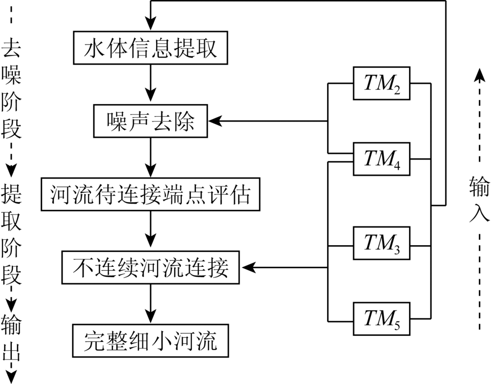
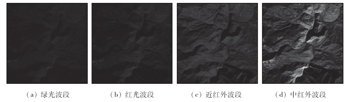
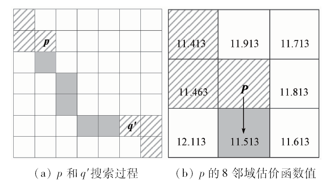
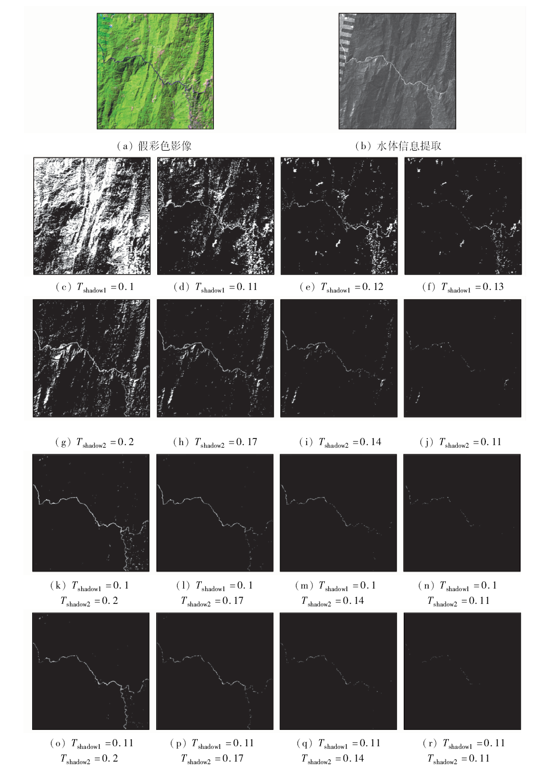
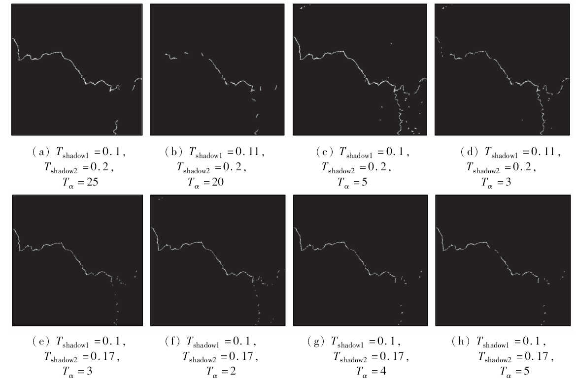
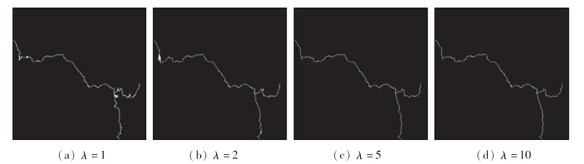
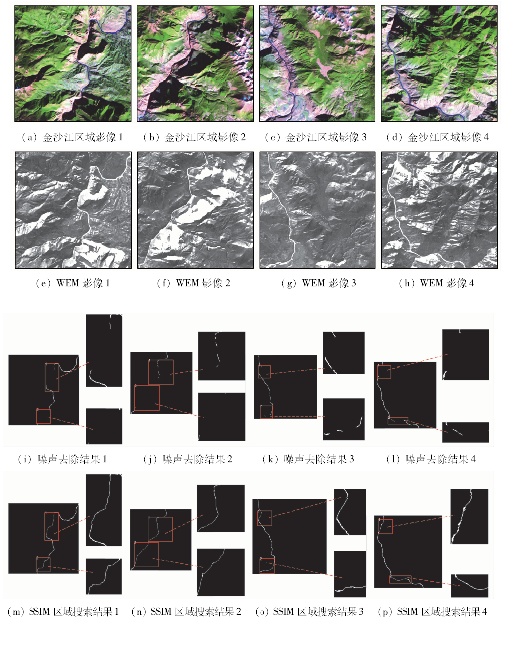
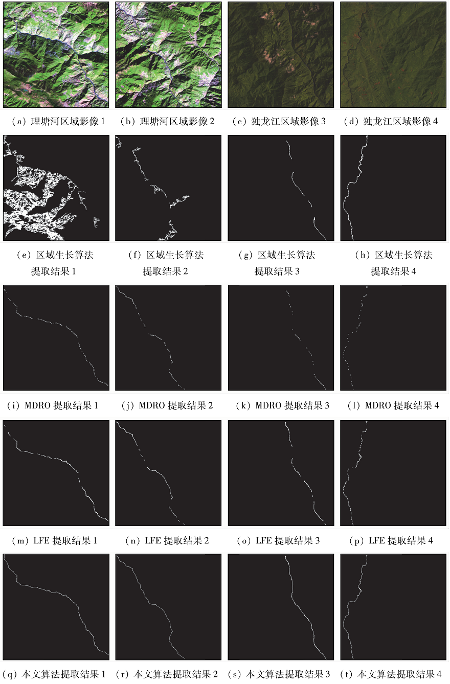
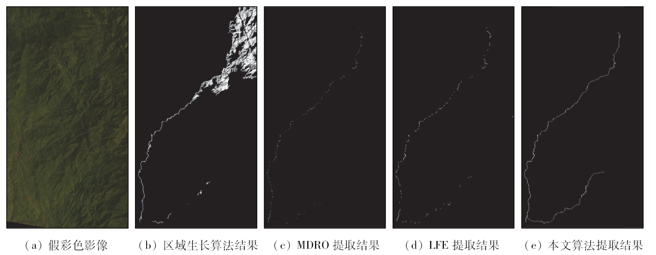
Abstract The structural similarity region search algorithm is used to realize the automatic extraction of TM image narrow rivers, which is of great value for disaster assessment and soil and water resources management. The discontinuity of narrow river extraction is the main problem which causes the difficulty in accurate obtaining of information about rivers. Many experts have studied various characteristic properties of water bodies to avoid the phenomenon of river information leakage during extraction. However, due to the complex flow of narrow rivers and the vulnerability to environmental disturbances, it is difficult to achieve complete extraction of river information. Combining structural similarity and heuristic search algorithm, this paper proposes a new method for accurately connecting faulted rivers. The specific process of the method is as follows: Firstly, according to the reflection characteristics of the ground objects, the water body extraction model is used to distinguish the narrow rivers from the irrelevant information. Then, the difference between the gray values of the water bodies on different bands is used to set different thresholds for unrelated noise removal. Third, the discontinuous rivers are evaluated by searching. The area is used to determine the breakpoints to be connected to the river. Finally, the heuristic automatic search connection is realized by using the structural similarity between the 5, 4, and 3 bands of river pixels in the TM image. A comparison with several algorithms shows that the proposed method can solve the problem of river extraction fracture of traditional algorithms and realize the precise connection of discontinuous narrow rivers.
|
| Keywords
remote sensing image
narrow rivers
heuristic search
structural similarity
|
|
|
|
Corresponding Authors:
Baoyun WANG
E-mail: wspbmly@163.com
|
|
Issue Date: 18 June 2020
|
|
|
| [1] |
Zhuang Y, Chen C. A method for water body extraction based on the tasselled cap transformation from remote sensing images [C]//2018 Fifth International Workshop on Earth Observation and Remote Sensing Applications(EORSA),Xi’an, 2018: 1-5.
|
| [2] |
Li N, Wang R, Liu Y, et al. Robust river boundaries extraction of dammed lakes in mountain areas after Wenchuan Earthquake from high resolution SAR images combining local connectivity and ACM[J]. ISPRS Journal of Photogrammetry and Remote Sensing, 2014,94:91-101.
|
| [3] |
Rundquist D C, Lawson M P, Queen L P, et al. The relationship between summer-season rainfall events and lake-surface area[J]. JAWRA Journal of the American Water Resources Association, 2007,23(3):493-508.
|
| [4] |
姜腾龙, 赵书河, 肖鹏峰, 等. 基于光谱夹角的水体信息提取方法研究[J] 国土资源遥感, 2009,21(2):102-105.doi: 10.6046/gtzyyg.2009.02.21.
|
| [4] |
Jiang T L, Zhao S H, Xiao P F, et al. Research on water body information extraction method based on spectral angle[J]. Remote Sensing for Land and Resources, 2009,(2):102-105.doi: 10.6046/gtzyyg.2009.02.21.
|
| [5] |
Mcffeters S K. The use of the normalized difference water index(NDWI) in the delineation of open water features[J]. International Journal of Remote Sensing, 1996,17(7):1425-1432.
doi: 10.1080/01431169608948714
url: https://www.tandfonline.com/doi/full/10.1080/01431169608948714
|
| [6] |
徐涵秋. 利用改进的归一化差异水体指数(MNDWI)提取水体信息的研究[J]. 遥感学报, 2005,9(5):589-595.
|
| [6] |
Xu H Q. A study on information extracting of water body with the modified normalized difference water index(MNDWI)[J]. Journal of Remote Sensing, 2005,9(5):589-595.
|
| [7] |
Bo S, Jing Y. One-class classification based river detection in remote sensing image [C]// International Congress on Image & Signal Processing.IEEE, 2018.
|
| [8] |
Xin Z, Ping W, Chao C, et al. Waterbody information extraction from remote-sensing images after disasters based on spectral information and characteristic knowledge[J]. International Journal of Remote Sensing, 2017,38(5):1404-1422.
doi: 10.1080/01431161.2016.1278284
url: https://www.tandfonline.com/doi/full/10.1080/01431161.2016.1278284
|
| [9] |
张庆春, 佟国峰, 李勇, 等. 基于多特征融合和软投票的遥感图像河流检测[J]. 光学学报, 2018,38(6):320-326.
|
| [9] |
Zhang Q C, Yan G F, Li Y, et al. Remote sensing image river detection based on multi-feature fusion and soft voting[J]. Acta Optica Sinica, 2018,38(6):320-326.
|
| [10] |
朱长明, 骆剑承, 沈占锋, 等. DEM辅助下的河道细小线性水体自适应迭代提取[J]. 测绘学报, 2013,42(2):277-283.
|
| [10] |
Zhu C M, Luo J C, Shen Z F, et al. Adaptive iterative extraction of small linear water bodies in rivers assisted by DEM[J]. Acta Geoda Sinica, 2013,42(2):277-283.
|
| [11] |
Geling G, Ionescu D. An edge detection operator for SAR images [C]// Conference on Electrical & Computer Engineering.IEEE, 1993.
|
| [12] |
姜浩, 冯敏, 肖桐, 等. 基于线状特征增强的TM遥感影像细小河流提取方法[J]. 测绘学报, 2014,43(7):705-710.
|
| [12] |
Jiang H, Feng M, Xiao T, et al. A narrow river extraction method based on linear feature enhancement in TM image[J]. Acta Geodaetica et Cartographica Sinica, 2014,43(7):705-710.
|
| [13] |
杨树文, 薛重生, 刘涛, 等. 一种利用TM影像自动提取细小水体的方法[J]. 测绘学报, 2010,39(6):611-617.
|
| [13] |
Yang S W, Xue C S, Liu T, et al. A method for automatically extracting fine waters using TM images[J]. Journal of Surveying and Mapping, 2010,39(6):611-617.
|
| [14] |
周艺, 谢光磊, 王世新, 等. 利用伪归一化差异水体指数提取城镇周边细小河流信息[J]. 地球信息科学学报, 2014,16(1):102-107.
|
| [14] |
Zhou Y, Xie G L, Wang S X, et al. Extracting the information of small rivers around towns by pseudo-normalized difference water body index[J]. Journal of Geo-Information Science, 2014,16(1):102-107.
|
| [15] |
李艳华, 丁建丽, 闫人华. 基于国产GF-1遥感影像的山区细小水体提取方法研究[J]. 资源科学, 2015,37(2):408-416.
|
| [15] |
Li Y H, Ding J L, Yan R H. Research on extraction method of small water body in mountain area based on domestic GF-1 remote sensing image[J]. Resources Science, 2015,37(2):408-416.
|
| [16] |
Jensen J R. Introductory digital image processing:A remote sensing perspective[M]. NJ:Prentice Hall Logicon Geodynamics,Inc, 1996.
|
| [17] |
数据来源于中国科学院计算机网络信息中心地理空间数据云平台.Landsat4-5 TM(DB/OL).[2008-12-13].http://www.gscloud.cn.
url: http://www.gscloud.cn
|
| [17] |
The data set is provided by Geospatial Data Cloud site,Computer Network Information Center,Chinese Academy of Sciences.Landsat 4-5 TM(DB/OL).[2008-12-13].http://www.gscloud.cn.
url: http://www.gscloud.cn
|
| [18] |
杜云艳, 周成虎. 水体的遥感信息自动提取方法[J]. 遥感学报, 1998,2(4):264-269.
|
| [18] |
Du Y Y, Zhou C H. Automatically extracting remote sensing information for water bodies[J]. Journal of Remote Sensing, 1998,2(4):264-269.
|
| [19] |
Feyisa G L, Meilby H, Fensholt R, et al. Automated water extraction index:A new technique for surface water mapping using Landsat imagery[J]. Remote Sensing of Environment, 2014,140(1):23-35.
|
| [20] |
Wang Z, Bovik A C, Sheikh H R, et al. Image quality assessment:From error visibility to structural similarity[J]. IEEE Transactions on Image Processing, 2004,13(4):600-612.
doi: 10.1109/TIP.2003.819861
url: http://ieeexplore.ieee.org/document/1284395/
|
|
Viewed |
|
|
|
Full text
|
|
|
|
|
Abstract
|
|
|
|
|
Cited |
|
|
|
|
| |
Shared |
|
|
|
|
| |
Discussed |
|
|
|
|
 2020,
Vol. 32
2020,
Vol. 32
 ), Zhuhong ZHANG, Wenke HAN, Xianchen SUN, Lingli ZHANG