|
|
 |
|

|
|
|
Remote sensing survey of land occupied and damaged by abandoned mines along the Yangtze River Economic Belt and research on ecological remediation countermeasures |
| Yaqiu YIN, Jinzhong YANG, Jie WANG, Na AN, Yun JIANG |
| China Aero Geophysical Survey and Remote Sensing Center for Natural Resources, Beijing 100083, China |
|
|
|
|
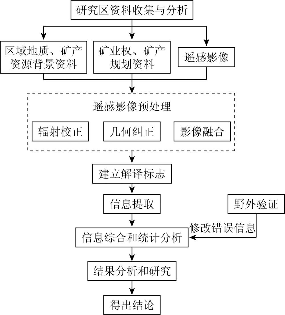
Abstract The Yangtze River Economic Belt is an important mineral resource base in China. Ecological and environmental problems caused by mineral resources exploitation are outstanding. In order to survey the situation of the land occupied and damaged by abandoned open-pit mines in this area and study the ecological remediation countermeasures, based on the domestic high spatial resolution remote sensing images acquired in 2016—2018 as the main data source, the authors used the techniques of remote sensing interpretation and information extraction to obtain the distribution information of the land occupied and damaged by abandoned open-pit mines in the range 50 km on the both sides of the main channel of the Yangtze River, which included Jinsha River in Sichuan and Yunnan Province and Yangtze River from Yibin to the estuary and the main tributaries which included Minjiang River, Tuojiang River, Chishui River, Jialing River, Wujiang River, Qingjiang River, Xiangjiang River, Hanjing River and Ganjiang River in the Yangtze River Economic Belt, and the geological hazard and environmental pollution information related to mining in the range of 10 km on the both sides of the river. The results show that in the range of 5 km, 10 km, 30 km, and 50 km from the main stream, the areas of the land occupied and damaged by abandoned open-air mines are 4 655.14 hm2, 8 787.57 hm2, 12 207.59 hm2, 21 040.85 hm2 and 30 034.47 hm2 respectively, and that for tributaries are 5 080.04 hm2, 8 644.25 hm2, 12 345.53 hm2, 21 290.29 hm2 and 33 491.49 hm2 respectively. Based on the results of remote sensing survey, the authors analyzed the environment of the abandoned open-air mines in the range of 10 km on the both sides of the Yangtze River main channel and main tributaries. The results show that the main problem in the upper reaches of the Yangtze River is that geological disasters caused by open mining and environmental pollution caused by metal and chemical raw material mines in the middle and lower reaches of the Yangtze River are quite serious. Combined with the advanced technology of mine environmental restoration, the authors put forward the countermeasures of mine ecological environmental restoration. Methods of slope reduction, slope cutting and slope reinforcement can be adopted to eliminate the hidden danger of collapse. Different green technologies can be used to prevent soil erosion according to the slope size. Artificial barrier layer, artificial fertilizer and microbial methods can be used for soil improvement. Toxic heavy metals in soil can be degraded by tolerant plants and microorganisms. Constructed wetlands can be built for water ecological restoration. The survey results and suggestions presented in this paper would provide the scientific bases and important references for the local mining administration on the ecological environmental remediation of the abandoned open-pit mines.
|
| Keywords
Yangtze River Economic Belt
abandoned open-air mine
remote sensing
ecological remediation
|
|
|
|
Issue Date: 18 June 2020
|
|
|
| [1] |
朱道才, 任以胜, 徐慧敏, 等. 长江经济带空间溢出效应时空分异[J]. 经济地理, 2016,36(6):26-33.
|
| [1] |
Zhu D C, Ren Y S, Xu H M, et al. The spatial-temporal differentiation of spatial spillover effect in Yangtze River Economic Belt[J]. Economic Geography, 2016,36(6):26-33.
|
| [2] |
肖庆文. 长江经济带生态补偿机制深化研究[J].科学发展, 2019(5):74-85.
|
| [2] |
Xiao Q W. Deep research on ecological compensation mechanism of the Yangtze River Economic Belt[J].Scientific Development, 2019(5):74-85.
|
| [3] |
樊莉, 文学虎, 张璇. 服务长江经济带绿色协调发展——四川局创新开展地理国情监测工作纪实[J].中国测绘, 2018(6):37-40.
|
| [3] |
Fan L, Wen X H, Zhang X. Serving the green coordinated development of the Yangtze River Economic Belt:The documentary of Sichuan Bureau’s innovation and implementation of geographical situation monitoring[J].China Surveying and Mapping, 2018(6):37-40.
|
| [4] |
殷缶, 梅深. 长江经济带发展上升为国家战略[J]. 水道港口, 2016,37(2):134.
|
| [4] |
Yin F, Mei S. The development of the Yangtze River Economic Belt has risen to the national strategy[J]. Journal of Waterway and Harbor, 2016,37(2):134.
|
| [5] |
陈建波. 区域经济视角下三峡工程系统服务长江经济带科学发展研究[D]. 武汉:武汉大学, 2017.
|
| [5] |
Chen J B. Research on the scientific development of the Yangtze River Economic Belt serving the three gorges project from the perspective of regional economy[D]. Wuhan:Wuhan University, 2017.
|
| [6] |
吴传清, 黄磊. 长江经济带绿色发展的难点与推进路径研究[J].南开学报(哲学社会科学版), 2017(3):50-61.
|
| [6] |
Wu C Q, Huang L. The difficulties and approaches of green development in the Yangtze River Economic Belt[J].Nankai Journal(Philosophy,Literature and Social Science Edition), 2017(3):50-61.
|
| [7] |
李想, 乌日娜, 郭志起, 等. 长江经济带建设与林业发展关系分析[J]. 林业经济, 2016,38(11):30-35.
|
| [7] |
Li X, Wu R N, Guo Z Q, et al. Analysis on the relationship between Yangtze River Economic Belt and forestry development[J].Forestry Economics, 2016(11):30-35.
|
| [8] |
李干杰. 坚持走生态优先、绿色发展之路扎实推进长江经济带生态环境保护工作[J]. 环境保护, 2016,44(11):7-13.
|
| [8] |
Li G J. Adhere to the ecological priority,green development and advance the Yangtze River Economic Belt of the ecological environment protection work[J]. Environmental Protection, 2016,44(11):7-13.
|
| [9] |
周飞. 湖北长江经济带小城市发展研究[D]. 武汉:华中师范大学, 2014.
|
| [9] |
Zhou F. Research on the development of small cities in the Yangtze River Economic Zone of Hubei Province[D]. Wuhan:Central China Normal University, 2014.
|
| [10] |
王钰, 张一诺, 张兴国. 2017 年两会政府工作报告中的林业生态看点[J]. 宁夏林业, 2017(2):8-10.
|
| [10] |
Wang Y, Zhang Y N, Zhang X G.Forestry ecology in the report on the work of the goverment of the two Sessions in 2017[J]. Ningxia Forestry Communication, 2017(2):8-10.
|
| [11] |
张玉韩, 王步清, 侯华丽. 长江经济带矿业产业协调发展研究[J]. 中国矿业, 2018,25(8):58-63.
|
| [11] |
Zhang Y H, Wang B Q, Hou H L. Research on the mining industry coordinated development of the Yangtze River Economic Belt[J]. China Mining Magazine, 2018,25(8):58-63.
|
| [12] |
刘立, 高俊华, 余德清. 基于遥感的湖南省矿山占地监测与分析[J]. 地理空间信息, 2019,17(1):41-46,11.
|
| [12] |
Liu L, Gao J H, Yu D Q. Monitoring and analysis of mine land occupation in Hunan Province based on remote sensing[J]. Geospatial Information, 2019,17(1):41-46,11.
|
| [13] |
管青春, 郝晋珉, 王宏亮, 等. 经济转型视角下矿产资源城市生态敏感性评价[J]. 农业工程学报, 2018,34(21):253-262,311.
|
| [13] |
Guan Q C, Hao J M, Wang H L, et al. Evaluation of ecological sensitivity of mineral resources city under economic transformation[J]. Transactions of the Chinese Society of Agricultural Engineering, 2018,34(21):253-262,311.
url: http://www.tcsae.org/nygcxb/ch/reader/view_abstract.aspx?file_no=20182132&flag=1
|
| [14] |
唐荣彬, 付梅臣, 陈勇. 控制采矿干扰扩散的生态关键地段识别研究——以大冶市为例[J].金属矿山, 2018(3):161-167.
|
| [14] |
Tang R B, Fu M C, Chen Y. Identification of ecological critical portion by controlling the diffusion of mining disturbance:A case of Daye City[J].Metal Mine, 2018(3):161-167.
|
| [15] |
李国政. 绿色发展视阈下矿山地质修复模式的升级与重塑[J]. 中国矿业大学学报(社会科学版), 2019,21(3):92-104.
|
| [15] |
Li G Z. Upgrading and reshaping of mine geological remediation mode from the perspective of green development[J]. Journal of China University of Mining and Technology(Social Sciences), 2019,21(3):92-104.
|
| [16] |
张超, 吕雅慧, 郧文聚, 等. 土地整治遥感监测研究进展分析[J]. 农业机械学报, 2019,50(1):1-22.
|
| [16] |
Zhang C, Lyu Y H, Yun W J, et al. Analysis on research progress of remote sensing monitoring of land consolidation[J]. Transactions of the Chinese Society of Agricultural Machinery, 2019,50(1):1-22.
|
| [17] |
查东平, 申展, 刘足根, 等. 基于TM影像的德兴铜矿区生态环境变化[J]. 国土资源遥感, 2015,27(4):109-114.doi: 10.6046/gtzyyg.2015.04.17.
|
| [17] |
Zha D P, Shen Z, Liu Z G, et al. Changes of ecological environment in the Dexing copper mine based on TM images[J]. Remote Sensing for Land and Resources, 2015,27(4):109-114.doi: 10.6046/gtzyyg.2015.04.17.
|
| [18] |
杨金中, 聂洪峰, 荆青青. 初论全国矿山地质环境现状与存在问题[J]. 国土资源遥感, 2017,29(2):1-7.doi: 10.6046/gtzyyg.2017.02.01.
|
| [18] |
Yang J Z, Nie H F, Jing Q Q. Preliminary analysis of mine geo-environment status and existing problems in China[J]. Remote Sensing for Land and Resources, 2017,29(2):1-7.doi: 10.6046/gtzyyg.2017.02.01.
|
| [19] |
陈书琳, 毕银丽. 遥感技术在微生物复垦中的应用研究[J]. 国土资源遥感, 2014,26(3):16-23.doi: 10.6046/gtzyyg.2014.03.03.
|
| [19] |
Chen S L, Bi Y L. Application of remote sensing technology to microbial reclamation[J]. Remote Sensing for Land and Resources, 2014,26(3):16-23.doi: 10.6046/gtzyyg.2014.03.03.
|
| [20] |
刘海波. 地质灾害治理工程施工中边坡稳定问题及滑坡治理方法[J].西部探矿工程, 2015(8):5-7,9.
|
| [20] |
Liu H B. Slope stability problem and landslide control method in construction of geological hazard control project[J].West-China Exploration Engineering, 2015(8):5-7,9.
|
| [21] |
罗祥明, 王路. 库区高陡边坡破坏模式机理与模拟研究[J]. 山西建筑, 2018,44(3):78-80.
|
| [21] |
Luo X M, Wang L. Along the high and steep slope rock mass mechanism analysis and control measures of the collapse[J]. Shanxi Architecture, 2018,44(3):78-80.
|
| [22] |
付江涛, 李光莹, 虎啸天, 等. 植物固土护坡效应的研究现状及发展趋势[J]. 工程地质学报, 2014,22(6):1135-1146.
doi: 10.13544/j.cnki.jeg.2014.06.018
url: http://www.gcdz.org/CN/abstract/abstract11620.shtml
|
| [22] |
Fu J T, Li G Y, Hu X T, et al. Research status and development tendency of vegetation effects to soil reinforcement and slope stabilization[J]. Journal of Engineering Geology, 2014,22(6):1135-1146.
doi: 10.13544/j.cnki.jeg.2014.06.018
url: http://www.gcdz.org/CN/abstract/abstract11620.shtml
|
|
Viewed |
|
|
|
Full text
|
|
|
|
|
Abstract
|
|
|
|
|
Cited |
|
|
|
|
| |
Shared |
|
|
|
|
| |
Discussed |
|
|
|
|
 2020,
Vol. 32
2020,
Vol. 32