|
|
|
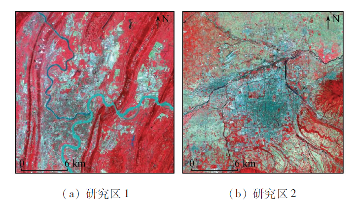
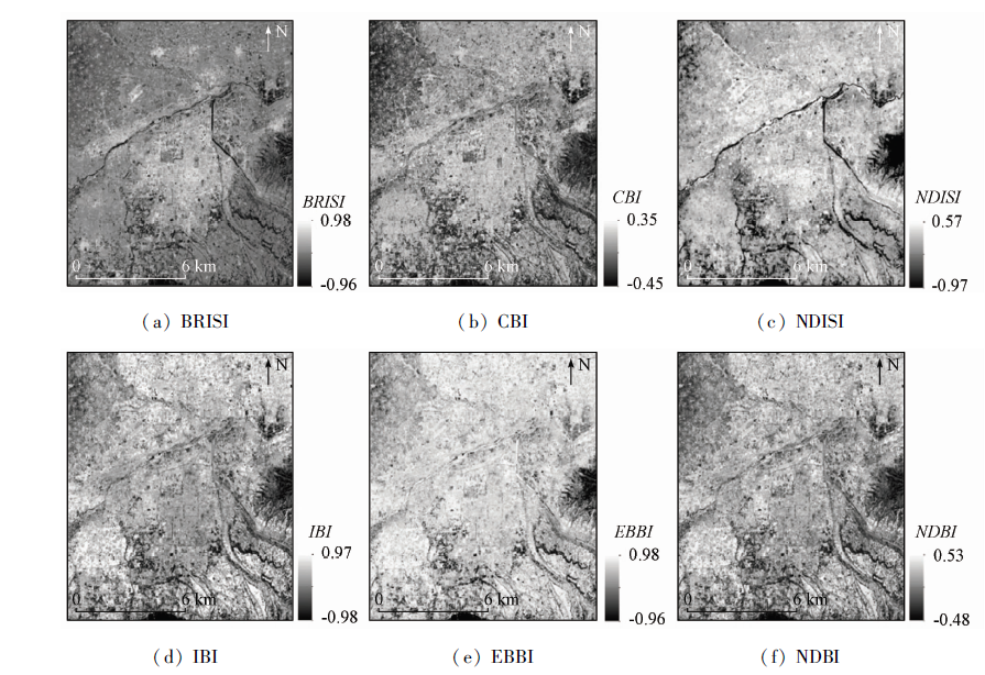
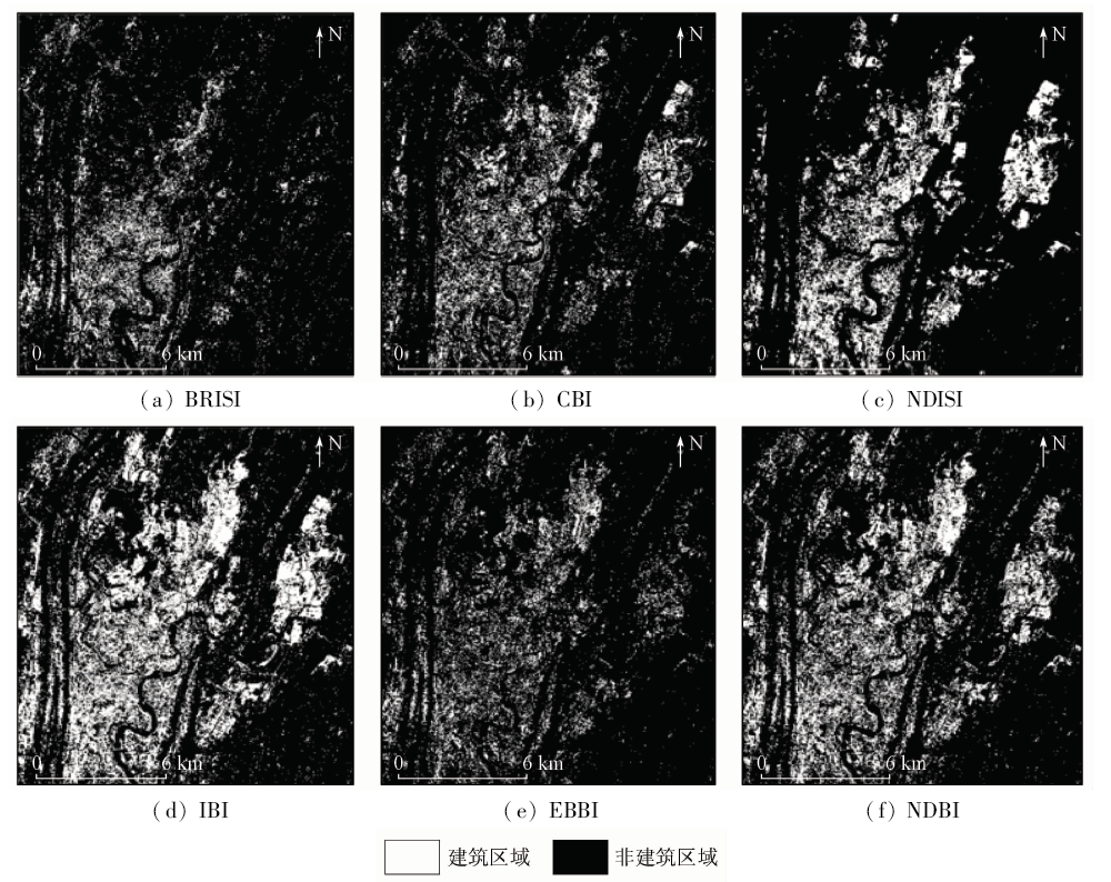
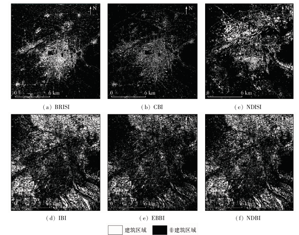
Abstract At present, the method of extracting the impervious surface area based on the impervious surface area according to the impervious surface spectral index has been widely used because of its concision and speed. However, the method of extracting impervious surface by spectral index has the disadvantage that bare land and impervious surface are easily confused. To tackle this problem, the authors created impervious surface and bareness area index (ISBAI) according to the spectral feature difference of impervious surface, bare land and water body as well as vegetation in the 4, 5 and 6 bands of Landsat8 OLI images. Based on ISBAI and bareness area index (BAI), the authors built a new type of impervious surface index, called the bareness - restrained impervious surface index (BRISI). Improved double-window flexible pace search (IDFPS) method was used to determine the optimal threshold, and impervious surface extraction was performed. Chongqing (a mountain city) and Xi’an (a plain city) were selected as the research area to evaluate the accuracy of BRISI extraction in comparison with other commonly used impervious surface indices. The experimental results show that the extraction accuracy of BRISI in the experimental area of Chongqing and Xi’an experimental area reach 86.8% and 86.8% respectively, in comparison with the accuracy of all other indices that took part in the contrast, BRISI extraction accuracy is the highest. Meanwhile, BRISI also eliminates the influence of bare land in the construction area extraction, and overcomes the problem that it is difficult for other impervious surface indices to distinguish bare land from impervious surface.
|
| Keywords
impervious surface
bare land
BRISI(bareness-restrained impervious surface index)
IDFPS(improved double-flexible pace search)
|
|
|
|
Corresponding Authors:
TAO Yuxiang
E-mail: 2289909272@qq.com;taoyx@cqupt.edu.cn
|
|
Issue Date: 09 October 2020
|
|
|
| [1] |
Slonecker E T, Jennings D B, Garofalo D. Remote sensing of impervious surfaces:A review[J]. Remote Sensing Reviews, 2001,20(3):227-255.
doi: 10.1080/02757250109532436
url: http://www.tandfonline.com/doi/abs/10.1080/02757250109532436
|
| [2] |
Zha Y, Gao J, Ni S. Use of normalized difference built-up index in automatically mapping urban areas from TM imagery[J]. International Journal of Remote Sensing, 2003,24(3):583-594.
doi: 10.1080/01431160304987
url: https://www.tandfonline.com/doi/full/10.1080/01431160304987
|
| [3] |
Assyakur A R, Adnyana I W S, Arthana I W, et al.Enhanced built-up and bareness index (EBBI) for mapping built-up and bare land in an urban area[J]. Remote Sensing, 2012,4(10):2957-2970.
doi: 10.3390/rs4102957
url: http://www.mdpi.com/2072-4292/4/10/2957
|
| [4] |
刘畅, 杨康, 程亮, 等. Landsat8不透水面遥感信息提取方法对比[J]. 国土资源遥感, 2019,31(3):148-158.doi: 10.6046/gtzyyg.2019.03.19.
|
| [4] |
Liu C, Yang K, Cheng L, et al. Comparison of remote sensing information extraction methods for Landsat8 impervious surface[J]. Remote Sensing for Land and Resources, 2019,31(3):148-158.doi: 10.6046/gtzyyg.2019.03.19.
|
| [5] |
Xu H. A new index for delineating built-up land features in satellite imagery[J]. International Journal of Remote Sensing, 2008,29(14):4269-4276.
doi: 10.1080/01431160802039957
url: https://www.tandfonline.com/doi/full/10.1080/01431160802039957
|
| [6] |
Sun G, Chen X, Jia X, et al. Combinational build-up index (CBI) for effective impervious surface mapping in urban areas[J]. IEEE Journal of Selected Topics in Applied Earth Observations & Remote Sensing, 2017,9(5):2081-2092.
|
| [7] |
Xu H Q. Analysis of impervious surface and its impact on urban heat environment using the normalized difference impervious surface index (NDISI)[J]. Photogrammetric Engineering & Remote Sensing, 2010,76(5):557-565.
|
| [8] |
Ridd M K. Exploring a V-I-S(vegetation-impervious surfacesoil)model for urban ecosystem analysis through remote sensing:Comparative anatomy for cities[J]. International Journal of Remote Sensing, 1995,16(12):2165-2185.
doi: 10.1080/01431169508954549
url: https://www.tandfonline.com/doi/full/10.1080/01431169508954549
|
| [9] |
Deng C, Wu C. BCI:A biophysical composition index for remote sensing of urban environments[J]. Remote Sensing of Environment, 2012,127(5):247-259.
doi: 10.1016/j.rse.2012.09.009
url: https://linkinghub.elsevier.com/retrieve/pii/S003442571200363X
|
| [10] |
Chen W, Liu L, Zhang C, et al. Monitoring the seasonal bare soil areas in Beijing using multitemporal TM images [C]//IEEE International Geoscience and Remote Sensing Symposium.IEEE, 2004,8292837.
|
| [11] |
Rogers A S, Kearney M S. Reducing signature variability in unmixing coastal marsh thematic mapper scenes using spectral indices[J]. International Journal of Remote Sensing, 2004,25(12):2317-2335.
doi: 10.1080/01431160310001618103
url: https://www.tandfonline.com/doi/full/10.1080/01431160310001618103
|
| [12] |
Zhao H, Chen X. Use of normalized difference bareness index in quickly mapping bare areas from TM/ETM+ [C]//Proceedings of Geoscience and Remote Sensing Symposium.IEEE, 2005: 1666-1668.
|
| [13] |
Li S, Chen X. A new bare-soil index for rapid mapping developing areas using Landsat8 data[J].ISPRS-International Archives of the Photogrammetry,Remote Sensing and Spatial Information Sciences, 2014,XL-4:139-144.
doi: 10.5194/isprsarchives-XL-4-139-2014
url: http://www.int-arch-photogramm-remote-sens-spatial-inf-sci.net/XL-4/139/2014/
|
| [14] |
李霞, 徐涵秋, 李晶, 等. 基于NDSI和NDISI指数的SPOT-5影像裸土信息提取[J]. 地球信息科学学报, 2016,18(1), 117-123.
doi: 10.3724/SP.J.1047.2016.00117
url: http://www.dqxxkx.cn/CN/abstract/abstract37172.shtml
|
| [14] |
Li X, Xu H Q, Li J, et al. Extraction of bare soil information from SPOT-5 image based on NDSI and NDISI index[J]. Journal of Geo-Information Science, 2016,18(1):117-123.
|
| [15] |
窦鹏, 陈洋波, 张涛, 等. 基于Landsat ETM+影像的增强型裸地指数研究[J]. 地理与地理信息科学, 2017,33(2):25-31.
|
| [15] |
Dou P, Chen Y B, Zhang T, et al. Study of enhanced bared land index using Landsat ETM+ imagery[J]. Geography and Geo-Information Science, 2017,33(2):25-31.
|
| [16] |
Chu Q W, Zhang H Q, Wu Y W, et al. Application research of Landsat-8[J]. Remote Sensing Information, 2013,28(4):110-114.
|
| [17] |
Tran D B, Puissant A, Badariotti D, et al. Optimizing spatial resolution of imagery for urban form detection:The cases of France and Vietnam[J]. Remote Sensing, 2011,3(10):2128-2147.
doi: 10.3390/rs3102128
url: http://www.mdpi.com/2072-4292/3/10/2128
|
| [18] |
Luo X B, Peng Y D, Gao Y H. An improved optimal segmentation threshold algorithm and its application in the built-up quick mapping[J]. Journal of the Indian Society of Remote Sensing, 2017,45(6):1-12.
doi: 10.1007/s12524-016-0569-2
url: http://link.springer.com/10.1007/s12524-016-0569-2
|
| [19] |
李志婷, 王昌昆, 潘贤章, 等. 基于模拟Landsat-8 OLI数据的小麦秸秆覆盖度估算[J]. 农业工程学报, 2016,32(s1):145-152.
|
| [19] |
Li Z T, Wang C K, Pan X Z, et al. Estimation of wheat straw mulching based on simulated Landsat-8 OLI data[J]. Transactions of the Chinese Society of Agricultural Engineering, 2016,32(s1):145-152.
|
|
Viewed |
|
|
|
Full text
|
|
|
|
|
Abstract
|
|
|
|
|
Cited |
|
|
|
|
| |
Shared |
|
|
|
|
| |
Discussed |
|
|
|
|
 2020,
Vol. 32
2020,
Vol. 32
 ), TAO Yuxiang1(