|
|
 |
|

|
|
|
Building change detection method combining Unet and IR-MAD |
XU Rui1( ), YU Xiaoyu1, ZHANG Chi1, YANG Jin1, HUANG Yu2, PAN Jun1() ), YU Xiaoyu1, ZHANG Chi1, YANG Jin1, HUANG Yu2, PAN Jun1() |
1. State Key Laboratory of Information Engineering in Surveying, Mapping and Remote Sensing, Wuhan University, Wuhan 430079, China
2. Wuda Geoinformatics Company Limited, Wuhan 430223, China |
|
|
|
|
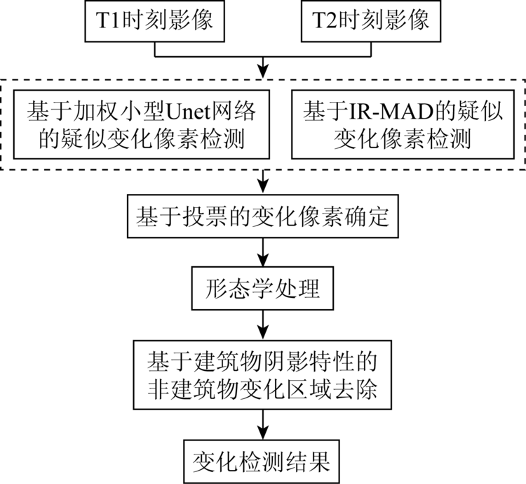
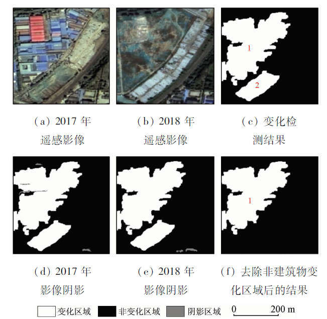
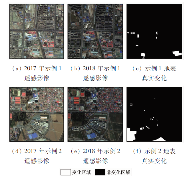
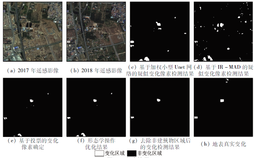
Abstract The change detection of urban buildings through remote sensing images can help researchers grasp the planning and implementation of urban buildings comprehensively, and assist urban managers to find and investigate illegal buildings. This paper proposes a method for urban building change detection that combines Unet with IR-MAD. This method first uses weighted small Unet and IR-MAD to detect suspected change pixels in remote sensing images, and then fuses the suspected change pixels detection results based on voting to find out change pixels. For optimizing the change pixel areas, morphological operations are performed to remove speckle noise and fill holes in the changed pixel area. Finally, non-building change areas are removed based on the shadow characteristics of the building to obtain building change detection results. Experiments show that this method can detect building changes in remote sensing images more accurately than using only Unet or IR-MAD.
|
| Keywords
convolutional neural segmentation network
iteratively weighted multivariate change detection
change detection
|
|
|
|
Corresponding Authors:
PAN Jun
E-mail: sherryxu@whu.edu.cn;panjun1215@whu.edu.cn
|
|
Issue Date: 23 December 2020
|
|
|
| [1] |
Singh A. Digital change detection techniques using remotely sensed data[J]. International Journal of Remote Sensing, 1988,10(6):989-1003.
|
| [2] |
Bruzzone L P. Automatic analysis of the difference image for unsupervised change detection[J]. IEEE Transactions on Geoscience and Remote Sensing, 2000,38:1171-1182.
|
| [3] |
Gupta A P R P. Land-use mapping and change detection in a coal mining area:A case study in the Jharia coalfield,India[J]. International Journal of Remote Sensing, 1998,19(3):391-410.
|
| [4] |
Jha C S, Unni N V M. Digital change detection of forest conversion of a dry tropical Indian forest region[J]. International Journal of Remote Sensing, 1994,15(13):2543-2552.
|
| [5] |
Moran M S. A window-based technique for combining Landsat Thematic Mapper thermal data with higher-resolution multispectral data over agricultural lands[J]. Photogrammetric Engineering and Remote Sensing, 1990,56(3):337-342.
|
| [6] |
杨存建, 欧晓昆, 党承林, 等. 森林植被动态变化信息的遥感检测[J]. 地球信息科学, 2000,2(4):71-74.
|
| [6] |
Yang C J, Ou X K, Dang C L, et al. Detecting the change information of forest vegetation in Lushui County of Yunnan Province[J]. Journal of Geo-Information Science, 2000,2(4):71-74.
|
| [7] |
Malila W A. Change vector analysis:An approach for detecting forest changes with Landsat[C]// Burroff P G.Machine processing of remotely sensed data,and soil information systems,and remote sensing and soil survey:Sixth annual symposium.Indiana:Institute of Electrical and Electronics Engineers, 1980: 385.
|
| [8] |
Xian G, Homer C, Fry J. Updating the 2001 National Land Cover Database land cover classification to 2006 by using Landsat imagery change detection methods[J]. Remote Sensing of Environment, 2009,113(6):1133-1147.
|
| [9] |
申祎, 王超, 胡佳乐. 一种结合空间与光谱信息的改进CVA变化检测方法[J]. 遥感技术与应用, 2019,34(4):799-806.
|
| [9] |
Shen Y, Wang C, Hu J L. An improved CVA change detection method combining spatial and spectral information[J]. Remote Sensing Technology and Application, 2019,34(4):799-806.
|
| [10] |
Celik T. Unsupervised change detection in satellite images using principal component analysis and K-means clustering[J]. IEEE Geoscience and Remote Sensing Letters, 2009,6(4):772-776.
|
| [11] |
赵秋菊. 改进主成分分析的遥感影像变化检测算法[J]. 测绘与空间地理信息, 2019,42(6):111-113.
|
| [11] |
Zhao Q J. Remote sensing image change detection algorithm based on improved principal component analysis[J]. Geomatics and Spatial Information Technology, 2019,42(6):111-113.
|
| [12] |
Zhong J, Wang R. Multi-temporal remote sensing change detection based on independent component analysis[J]. International Journal of Remote Sensing, 2006,27(10):2055-2061.
|
| [13] |
钟家强, 王润生. 基于独立成分分析的多时相遥感图像变化检测[J]. 电子与信息学报, 2006,28(6):994-998.
|
| [13] |
Zhong J Q, Wang R S. Multitemporal remote sensing images change detection based on ICA[J]. Journal of Elections and Information Technology, 2006,28(6):994-998.
|
| [14] |
Nielsen A A, Conradsen K, Simpson J J. Multivariate alteration detection (MAD) and MAF postprocessing in multispectral,bitemporal image data:New approaches to change detection studies[J]. Remote Sensing of Environment, 1998,64(1):1-19.
|
| [15] |
Wu C, Du B, Zhang L. Slow feature analysis for change detection in multispectral imagery[J]. IEEE Transactions on Geoscience and Remote Sensing, 2014,52(5):2858-2874.
|
| [16] |
Wu C, Zhang L, Du B. Kernel slow feature analysis for scene change detection[J]. IEEE Transactions on Geoscience and Remote Sensing, 2017,55(4):2367-2384.
|
| [17] |
Nielsen A A. The regularized iteratively reweighted MAD method for change detection in multi-and hyperspectral data[J]. IEEE Transactions on Image Processing, 2007,16(2):463-478.
pmid: 17269639
url: https://www.ncbi.nlm.nih.gov/pubmed/17269639
|
| [18] |
张续, 江涛, 胡世明, 等. 迭代加权多元变化检测算法在高分辨率遥感影像变化检测中应用[J]. 计算机应用, 2019,39(s1):177-181.
|
| [18] |
Zhang X, Jiang T, Hu S M, et al. Application of iteratively re-weighted multivariate alteration detection in high-resolution remote sensing images change detection[J]. Journal of Computer Applications, 2019,39(s1):177-181.
|
| [19] |
Xian G, Homer C, Fry J. Updating the 2001 national land cover database land cover classification to 2006 by using Landsat imagery change detection methods[J]. Remote Sensing of Environment, 2009,113(6):1133-1147.
|
| [20] |
季顺平, 田思琦, 张驰. 利用全空洞卷积神经元网络进行城市土地覆盖分类与变化检测[J]. 武汉大学学报(信息科学版), 2020,45(2):233-241.
|
| [20] |
Ji S P, Tian S Q, Zhang C. Urban land cover classification and change detection using fully atrous convolutional neural network[J]. Geomatics and Information Science of Wuhan University, 2020,45(2):233-241.
|
| [21] |
Gil-Yepes J L, Ruiz L A, Recio J A, et al. Description and validation of a new set of object-based temporal geostatistical features for land-use/land-cover change detection[J]. ISPRS Journal of Photogrammetry and Remote Sensing, 2016,121:77-91.
|
| [22] |
眭海刚, 冯文卿, 李文卓, 等. 多时相遥感影像变化检测方法综述[J]. 武汉大学学报(信息科学版), 2018,43(12):132-145.
|
| [22] |
Sui H G, Feng W Q, Li W Z, et al. Review of change detection methods for multi-temporal remote sensing imagery[J]. Geomatics and Information Science of Wuhan University, 2018,43(12):132-145.
|
| [23] |
Ronneberger O, Fischer P, Brox T. U-net:Convolutional networks for biomedical image segmentation[C]// Navab N,Hornegger J,Wells W,et al.Medical image computing and computer-assisted intervention-MICCAI 2015.Munich:Springer Cham, 2015:234-241.
|
| [24] |
Chen L C, Papandreou G, Kokkinos I, et al. DeepLab:Semantic image segmentation with deep convolutional nets,atrous convolution,and fully connected CRFs[J]. IEEE Transactions on Pattern Analysis and Machine Intelligence, 2016,40(4):834-848.
doi: 10.1109/TPAMI.2017.2699184
pmid: 28463186
url: https://www.ncbi.nlm.nih.gov/pubmed/28463186
|
| [25] |
Wu H, Zhang J, Huang K, et al. FastFCN:Rethinking dilated convolution in the backbone for semantic segmentation[EB/OL]. (2019-03-28)[2020-01-15]. http://arxiv.org.abs/1903.11816.
url: http://arxiv.org.abs/1903.11816
|
| [26] |
Ma L, Liu Y, Zhang X, et al. Deep learning in remote sensing applications:A meta-analysis and review[J]. ISPRS Journal of Photogrammetry and Remote Sensing, 2019,152:166-177.
|
| [27] |
Chu Y, Cao G, Hayat H. Change detection of remote sensing image based on deep neural networks[C]//Sehiemy R E,Reaz M B I,Lee C J.2016 2nd International Conference on Artificial Intelligence and Industrial Engineering (AIIE 2016). Paris:Atlantis Press, 2016:262-267.
|
| [28] |
Lebedev M A, Vizilter Y V, Vygolov O V, et al. Change detection in remote sensing images using conditional adversarial networks[J]. International Archives of the Photogrammetry,Remote Sensing and Spatial Information Sciences, 2018,42(2):565-571.
|
| [29] |
张鑫龙, 陈秀万, 李飞, 等. 高分辨率遥感影像的深度学习变化检测方法[J]. 测绘学报, 2017,46(8):999-1008.
|
| [29] |
Zhang X L, Chen X W, Li F, et al. Change detection method for high resolution remote sensing images using deep learning[J]. Acta Geodaetica et Cartographica Sinica, 2017,46(8):999-1008.
|
| [30] |
Vignesh T, Thyagharajan K K, Ramya K. Change detection using deep learning and machine learning techniques for multispectral satellite images[J]. International Journal of Innovative Technology and Exploring Engineering, 2019(9):90-93.
|
| [31] |
Srivastava N, Hinton G, Krizhevsky A, et al. Dropout:A simple way to prevent neural networks from overfitting[J]. The Journal of Machine Learning Research, 2014,15(1):1929-1958.
|
| [32] |
刘辉, 谢天文. 基于PCA与HIS模型的高分辨率遥感影像阴影检测研究[J]. 遥感技术与应用, 2013,28(1):81-87.
|
| [32] |
Liu H, Xie T W. Study on shadow detection in high resolution remote sensing image of PCA and HIS model[J]. Remote Sensing of Technology and Application, 2013,28(1):81-87.
|
|
Viewed |
|
|
|
Full text
|
|
|
|
|
Abstract
|
|
|
|
|
Cited |
|
|
|
|
| |
Shared |
|
|
|
|
| |
Discussed |
|
|
|
|
 2020,
Vol. 32
2020,
Vol. 32