|
|
 |
|

|
|
|
Construction of new vegetation water index based on PROSPECT-VISIR model |
WANG Jie1( ), WANG Guanghui1,2(), LIU Yu1, QI Jianwei1, ZHANG Tao1 ), WANG Guanghui1,2(), LIU Yu1, QI Jianwei1, ZHANG Tao1 |
1. Land Satellite Remote Sensing Application Center, MNR, Beijing 100048, China
2. School of Environment and Spatial Informatics, China University of Mining and Technology, Xuzhou 221116, China |
|
|
|
|
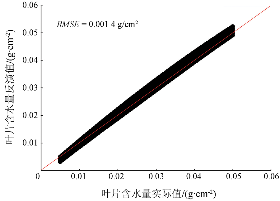
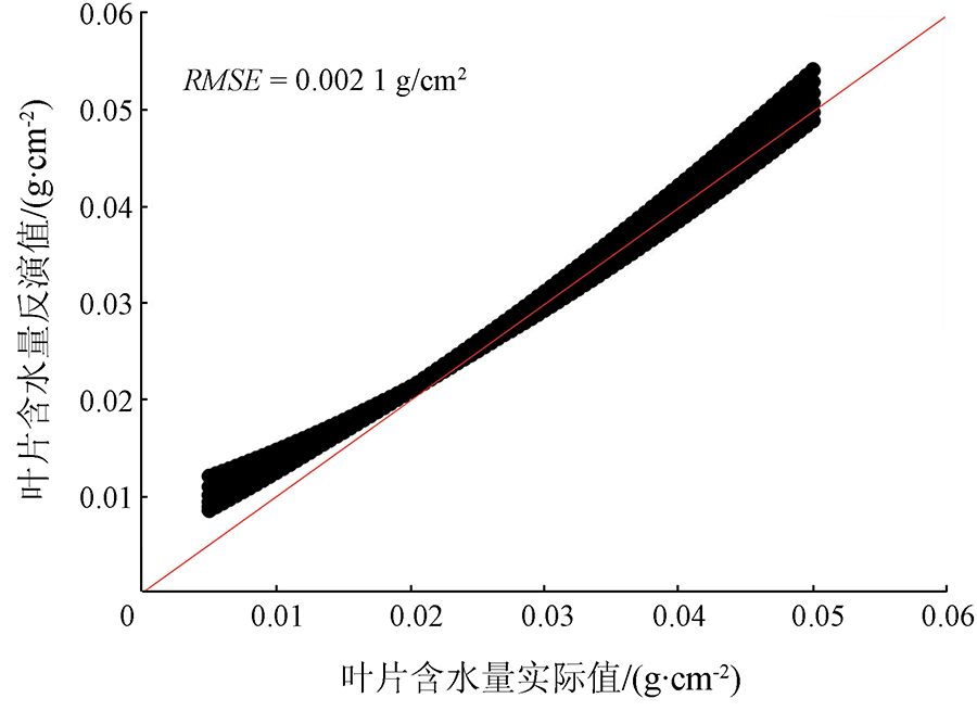
Abstract In this paper, the leaf reflectance simulation data of visible to mid-infrared spectral range under the condition of different leaf parameters were obtained using the PROSPECT-VISIR leaf model. The spectral characteristic bands of vegetation leaves were analyzed to find the range of bands within which leaf reflectance is sensitive to changes in water content. On the basis of several common vegetation water indexes derived from visible and near-infrared bands, four new vegetation water index models were proposed by addition of the reflectance of the mid-infrared band, namely mid-infrared normalized difference infrared index (NDIIM), mid-infrared normalized difference water index (NDWIM), mid-infrared normalized multi-band drought index (NMDIM) and mid-infrared normalized difference vegetation index (NDVIM). Based on the leaf reflectance simulation data, the sensitivity of four new vegetation water indexes and that of common water index to leaf water content were compared, and the quantitative relationship model between, on one hand, new vegetation water index and, on the other hand, leaf water content and dry matter content, was established. The fitting degree of NMDIM was 0.972, showing the best performance. Finally, a leaf water content estimation model was developed based on two new vegetation water indexes NMDIM and NDIIM so that accurate estimation of leaf water content can be achieved even when the dry matter content is unknown (the root mean square error of the model was 0.002 1g/cm2).
|
| Keywords
leaf radiative transfer model
vegetation water index
mid-infrared reflectance
leaf water content
|
|
|
|
Corresponding Authors:
WANG Guanghui
E-mail: wangjie0039@163.com;wanggh@lasac.cn
|
|
Issue Date: 20 June 2022
|
|
|
| [1] |
Datt B. Remote sensing of water content in Eucalyptus leaves[J]. Australian Journal of Botany, 1999, 47(6):909-923.
doi: 10.1071/BT98042
url: http://www.publish.csiro.au/?paper=BT98042
|
| [2] |
Penuelas J, Gamon J A, Griffin K L, et al. Assessing community type,plant biomass,pigment composition,and photosynthetic efficiency of aquatic vegetation from spectral reflectance[J]. Remote Sensing of Environment, 1993, 46(2):110-118.
doi: 10.1016/0034-4257(93)90088-F
url: https://linkinghub.elsevier.com/retrieve/pii/003442579390088F
|
| [3] |
Bauer M E, Daughtry C S T, Biehl L L, et al. Field spectroscopy of agricultural crops[J]. IEEE Transactions on Geoscience and Remote Sensing, 1986(1):65-75.
|
| [4] |
Chuvieco E, Riaño D, Aguado I, et al. Estimation of fuel moisture content from multitemporal analysis of Landsat Thematic Mapper reflectance data:Applications in fire danger assessment[J]. International Journal of Remote Sensing, 2002, 23(11):2145-2162.
doi: 10.1080/01431160110069818
url: https://www.tandfonline.com/doi/full/10.1080/01431160110069818
|
| [5] |
Hunt E R, Rock B N, Nobel P S. Measurement of leaf relative water content by infrared reflectance[J]. Remote Sensing of Environment, 1987, 22(3):429-435.
doi: 10.1016/0034-4257(87)90094-0
url: https://linkinghub.elsevier.com/retrieve/pii/0034425787900940
|
| [6] |
Bannari A, Morin D, Bonn F, et al. A review of vegetation indices[J]. Remote Sensing Reviews, 1995, 13(1-2):95-120.
doi: 10.1080/02757259509532298
url: http://www.tandfonline.com/doi/abs/10.1080/02757259509532298
|
| [7] |
Peñuelas J, Pinol J, Ogaya R, et al. Estimation of plant water concentration by the reflectance water index WI (R900/R970)[J]. International Journal of Remote Sensing, 1997, 18(13):2869-2875.
doi: 10.1080/014311697217396
url: https://www.tandfonline.com/doi/full/10.1080/014311697217396
|
| [8] |
Ceccato P, Gobron N, Flasse S, et al. Designing a spectral index to estimate vegetation water content from remote sensing data:Part 1:Theoretical approach[J]. Remote Sensing of Environment, 2002, 82(2):188-197.
doi: 10.1016/S0034-4257(02)00037-8
url: https://linkinghub.elsevier.com/retrieve/pii/S0034425702000378
|
| [9] |
Hardisky M, Klemas V, Smart M. The influence of soil salinity,growth form,and leaf moisture on the spectral radiance[J]. Spartina Alterniflora, 1983, 49:77-83.
|
| [10] |
Gao B C. NDWI:A normalized difference water index for remote sensing of vegetation liquid water from space[J]. Remote Sensing of Environment, 1996, 58(3):257-266.
doi: 10.1016/S0034-4257(96)00067-3
url: https://linkinghub.elsevier.com/retrieve/pii/S0034425796000673
|
| [11] |
Wang L L,and John J Q. NMDI:A normalized multi-band drought index for monitoring soil and vegetation moisture with satellite remote sensing[J]. Geophysical Research Letters, 2007, 34:20.
|
| [12] |
Rouse J W, et al. Monitoring vegetation systems in the Great Plains with ERTS[J]. NASA Special Publication, 1974, 351:309.
|
| [13] |
Boyd D S. The relationship between the biomass of Cameroonian tropical forests and radiation reflected in middle infrared wavelengths (3.0-5.0 mu m)[J]. International Journal of Remote Sensing, 1999, 20(5):1017-1023.
doi: 10.1080/014311699213055
url: https://www.tandfonline.com/doi/full/10.1080/014311699213055
|
| [14] |
Kaufman Y J, Remer L A. Detection of forests using mid-IR reflectance:An application for aerosol studies[J]. IEEE Transactions on Geoscience and Remote Sensing, 1994, 32(3):672-683.
doi: 10.1109/36.297984
url: http://ieeexplore.ieee.org/document/297984/
|
| [15] |
Carter G A. Primary and secondary effects of water content on the spectral reflectance of leaves[J]. American Journal of Botany, 1991, 78(7): 916-924.
doi: 10.1002/j.1537-2197.1991.tb14495.x
url: https://onlinelibrary.wiley.com/doi/10.1002/j.1537-2197.1991.tb14495.x
|
| [16] |
Libonati R, DaCamara C C, Pereira J M C, et al. A new optimal index for burnt area discrimination in satellite imagery[C]// 2007 EUMETSAT Meteorological Satellite Conference and the 15th American Meteorological Society (AMS) Satellite Meteorological & Oceanography Conference.Germany:Darmstadt, 2007:24-28.
|
| [17] |
Vescovo L, Gianelle D. Using the MIR bands in vegetation indices for the estimation of grassland biophysical parameters from satellite remote sensing in the Alps region of Trentino (Italy)[J]. Advances in Space Research, 2008, 41(11):1764-1772.
doi: 10.1016/j.asr.2007.07.043
url: https://linkinghub.elsevier.com/retrieve/pii/S0273117707008472
|
| [18] |
Tang B H, Jia Y Y, Zhang X, et al. Vegetation monitoring with surface bi-directional reflectivities in MODIS near-IR and mid-IR channels[C]// International Geoscience and Remote Sensing Symposium.IEEE, 2007:3333-3336.
|
| [19] |
Ullah S, Skidmore A K, Naeem M, et al. An accurate retrieval of leaf water content from mid to thermal infrared spectra using continuous wavelet analysis[J]. Science of the Total Environment, 2012, 437:145-152.
doi: 10.1016/j.scitotenv.2012.08.025
url: https://linkinghub.elsevier.com/retrieve/pii/S0048969712010960
|
| [20] |
Ullah S, Skidmore A K, Ramoelo A, et al. Retrieval of leaf water content spanning the visible to thermal infrared spectra[J]. ISPRS Journal of Photogrammetry and Remote Sensing, 2014, 93:56-64.
doi: 10.1016/j.isprsjprs.2014.04.005
url: https://linkinghub.elsevier.com/retrieve/pii/S0924271614000926
|
| [21] |
Arshad M, Ullah S, Khurshid K, et al. Estimation of leaf water content from mid-and thermal-infrared spectra by coupling genetic algorithm and partial least squares regression[J]. Journal of Applied Remote Sensing, 2018, 12(2):022203.
|
| [22] |
Jacquemoud S, Baret F. PROSPECT:A model of leaf optical properties spectra[J]. Remote Sensing of Environment, 1990, 34(2):75-91.
doi: 10.1016/0034-4257(90)90100-Z
url: https://linkinghub.elsevier.com/retrieve/pii/003442579090100Z
|
| [23] |
Gerber F, Marion R, Olioso A., et al. Modeling directional-hemispherical reflectance and transmittance of fresh and dry leaves from 0.4 μm to 5.7 μm with the PROSPECT-VISIR model[J]. Remote Sensing of Environment, 2011, 115(2):404-414.
doi: 10.1016/j.rse.2010.09.011
url: https://linkinghub.elsevier.com/retrieve/pii/S0034425710002841
|
|
Viewed |
|
|
|
Full text
|
|
|
|
|
Abstract
|
|
|
|
|
Cited |
|
|
|
|
| |
Shared |
|
|
|
|
| |
Discussed |
|
|
|
|
 2022,
Vol. 34
2022,
Vol. 34