|
|
 |
|

|
|
|
Detection of changes in SAR images based on an improved fully-connected conditional random field |
DONG Ting1,2( ), FU Weiqi1,2, SHAO Pan1,2(), GAO Lipeng3, WU Changdong1,2 ), FU Weiqi1,2, SHAO Pan1,2(), GAO Lipeng3, WU Changdong1,2 |
1. Hubei Key Laboratory of Intelligent Vision Monitoring for Hydropower Engineering, China Three Gorges University, Yichang 443002, China
2. College of Computer and Information Technology, China Three Gorges University, Yichang 443002, China
3. School of Software, Northwestern Polytechnical University, Xi’an 710129, China |
|
|
|
|
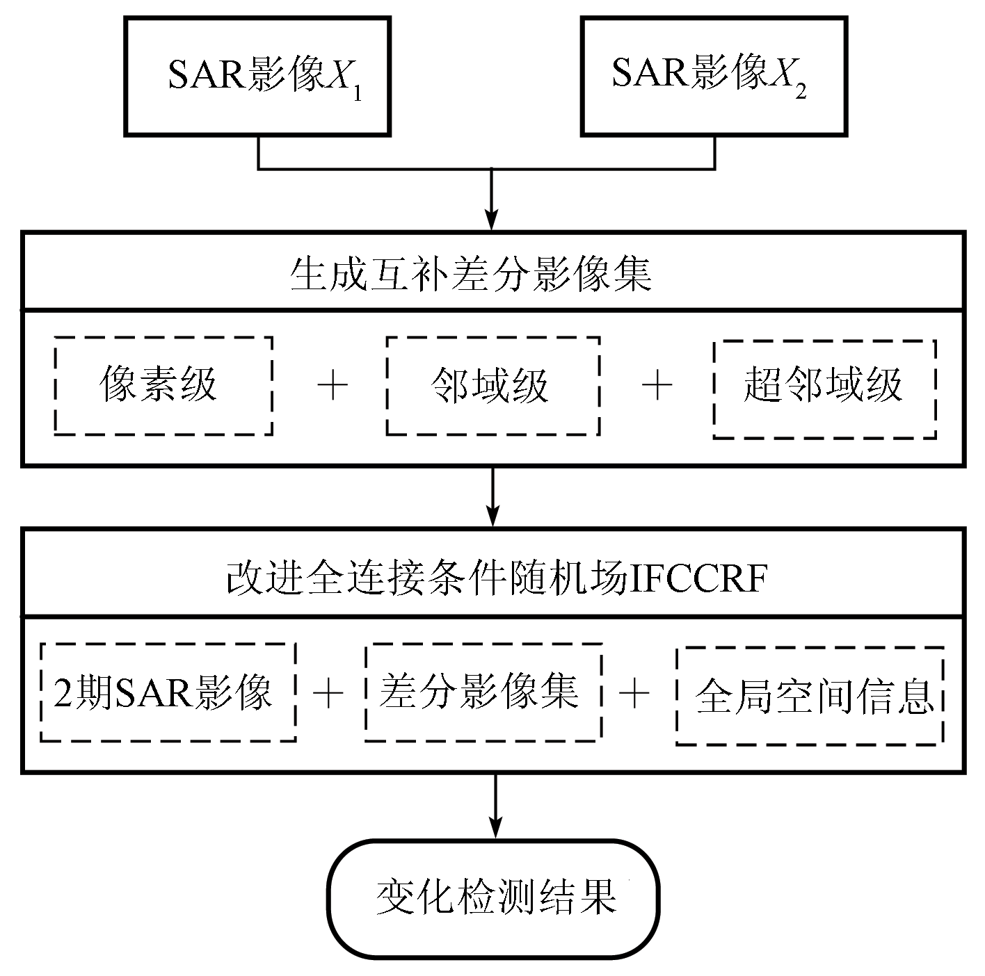
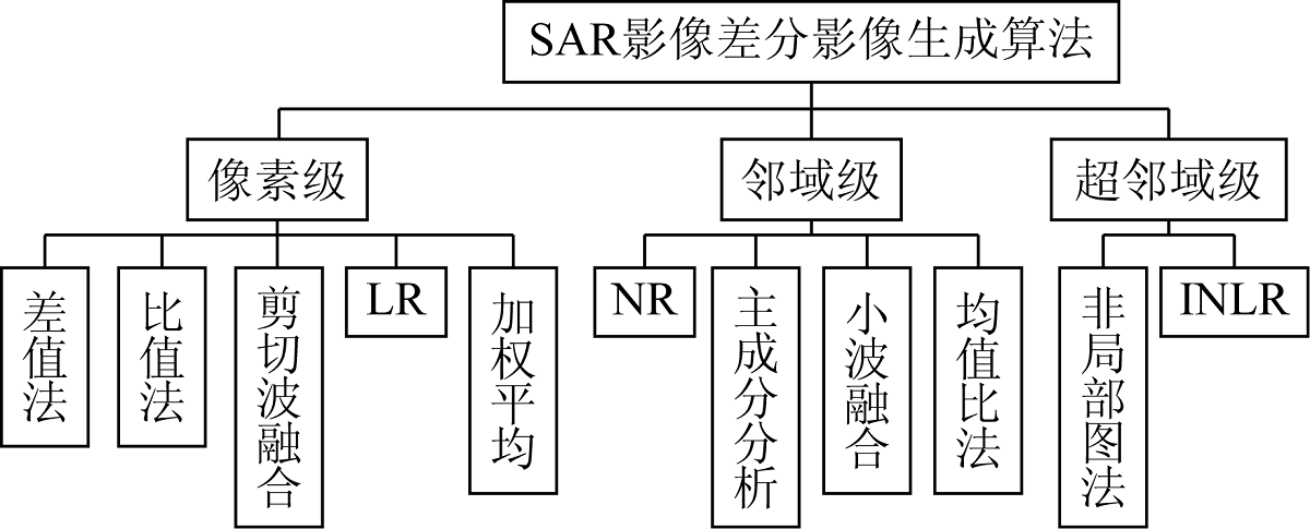
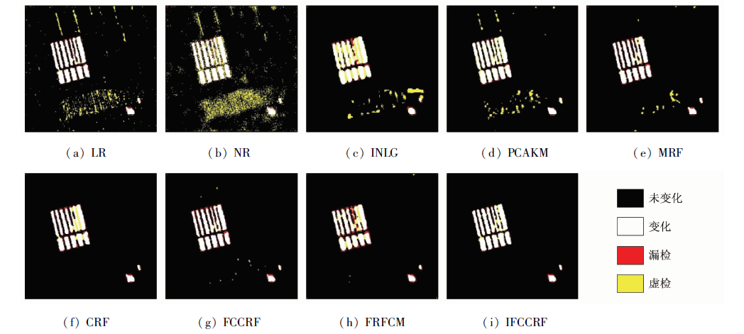
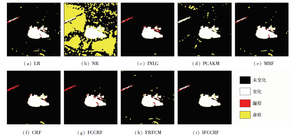
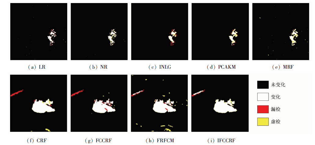
Abstract Change detection is the research focus of remote sensing. To overcome the shortcomings of the existing conditional random field (CRF)-based change detection, this study proposed a novel change detection method for synthetic aperture Radar (SAR) images based on an improved fully connected CRF (FCCRF). Firstly, this study summarized the comparative algorithms for generating differential images from SAR images, which were divided into three levels, namely pixel, neighborhood, and super-neighborhood. Then, this study selected three typical comparative algorithms-log ratio (LR), neighborhood ratio (NR), and improved non-local graph (INLG)-to produce three sets of complementary differential images. Finally, this study improved the FCCRF by extending the number of Gaussian kernels of the pairwise potential function of FCCRF and generated the change detection maps using the improved FCCRF model. The change detection method proposed in this study integrated the two-phase original SAR images, three sets of complementary differential images, and the global spatial information of images. In addition, this study presented a simple and effective parameter determination strategy, which allows the FCCRF to perform the change detection automatically. Experimental results on four sets of real SAR image data confirmed the effectiveness of the change detection method proposed in this study.
|
| Keywords
remote sensing
unsupervised change detection
SAR image
differential image
conditional random field
|
|
|
|
Issue Date: 19 September 2023
|
|
|
| [1] |
公茂果, 苏临之, 李豪, 等. 合成孔径雷达影像变化检测研究进展[J]. 计算机研究与发展, 2016, 53(1):123-147.
|
| [1] |
Gong M G, Su L Z, Li H, et al. A survey on change detection in synthetic aperture Radar imagery[J]. Journal of Computer Research and Development, 2016, 53(1):123-147.
|
| [2] |
王译著, 黄亮, 陈朋弟, 等. 联合显著性和多方法差异影像融合的遥感影像变化检测[J]. 自然资源遥感, 2021, 33(3):89-96.doi:10.6046/zrzyyg.2020312.
doi: 10.6046/zrzyyg.2020312
|
| [2] |
Wang Y Z, Huang L, Chen P D, et al. Change detection of remote sensing images based on the fusion of co-saliency difference images[J]. Remote Sensing for Natural Resources, 2021, 33(3):89-96.doi:10.6046/zrzyyg.2020312.
doi: 10.6046/zrzyyg.2020312
|
| [3] |
吴柳青, 胡翔云. 基于多尺度多特征的高空间分辨率遥感影像建筑物自动化检测[J]. 国土资源遥感, 2019, 31(1):71-78.doi:10.6046/gtzyyg.2019.01.10.
doi: 10.6046/gtzyyg.2019.01.10
|
| [3] |
Wu L Q, Hu X Y. Automatic building detection of high-resolution remote sensing images based on multi-scale and multi-feature[J]. Remote Sensing for Land and Resources, 2019, 31(1):71-78.doi:10.6046/gtzyyg.2019.01.10.
doi: 10.6046/gtzyyg.2019.01.10
|
| [4] |
何陈临秋, 程博, 陈金奋, 等. 基于GF-3全极化SAR数据的滨海湿地信息提取方法[J]. 自然资源遥感, 2021, 33(4):105-110.doi:10.6046/zrzyyg.2020353.
doi: 10.6046/zrzyyg.2020353
|
| [4] |
He C L Q, Cheng B, Chen J F, et al. Information extraction methods of coastal wetland based on GF-3 fully polarimetric SAR data[J]. Remote Sensing for Natural Resources, 2021, 33(4):105-110.doi:10.6046/zrzyyg.2020353.
doi: 10.6046/zrzyyg.2020353
|
| [5] |
Gong M G, Li Y, Jiao L C, et al. SAR change detection based on intensity and texture changes[J]. ISPRS Journal of Photogrammetry and Remote Sensing, 2014, 93(7):123-135.
doi: 10.1016/j.isprsjprs.2014.04.010
url: https://linkinghub.elsevier.com/retrieve/pii/S0924271614001051
|
| [6] |
王建明, 史文中, 邵攀. 自适应距离和模糊拓扑优化的模糊聚类SAR影像变化检测[J]. 测绘学报, 2018, 47(5):611-619.
doi: 10.11947/j.AGCS.2018.20160607
|
| [6] |
Wang J M, Shi W Z, Shao P. Change detection method for SAR image using adaptive distance and fuzzy topology optimization-based fuzzy clustering[J]. Acta Geodaetica et Cartographica Sinica, 2018, 47(5):611-619.
|
| [7] |
庄会富, 邓喀中, 余美, 等. 结合KI准则和逆高斯模型的SAR影像非监督变化检测[J]. 武汉大学学报(信息科学版), 2018, 43(2):282-288.
|
| [7] |
Zhuang H F, Deng K Z, Yu M, et al. A novel approach combining KI criterion and inverse Gaussian model to unsupervised change detection in SAR images[J]. Geomatics and Information Science of Wuhan University, 2018, 43(2):282-288.
|
| [8] |
Sun Y L, Lei L, Guan D D, et al. SAR image change detection based on nonlocal low-rank model and two-level clustering[J]. IEEE Journal of Selected Topics in Applied Earth Observations and Remote Sensing, 2020, 1(99):1-14.
doi: 10.1109/JSTARS.4609443
url: https://ieeexplore.ieee.org/xpl/RecentIssue.jsp?punumber=4609443
|
| [9] |
Bazi Y, Bruzzone L, Melgani F. An unsupervised approach based on the generalized Gaussian model to automatic change detection in multitemporal SAR images[J]. IEEE Transactions on Geoscience and Remote Sensing, 2005, 43(4):874-887.
doi: 10.1109/TGRS.2004.842441
url: http://ieeexplore.ieee.org/document/1411993/
|
| [10] |
Moser G, Serpico S B. Generalized minimum-error thresholding for unsupervised change detection from SAR amplitude imagery[J]. IEEE Transactions on Geoscience and Remote Sensing, 2006, 44(10):2972-2982.
doi: 10.1109/TGRS.2006.876288
url: http://ieeexplore.ieee.org/document/1704990/
|
| [11] |
Celik T. Change detection in satellite images using a genetic algorithm approach[J]. IEEE Geoscience and Remote Sensing Letters, 2010, 7(2):386-390.
doi: 10.1109/LGRS.2009.2037024
url: http://ieeexplore.ieee.org/document/5395684/
|
| [12] |
Inglada J, Mercier G. A new statistical similarity measure for change detection in multitemporal SAR images and its extension to multiscale change analysis[J]. IEEE Transactions on Geoscience and Remote Sensing, 2007, 45(5):1432-1445.
doi: 10.1109/TGRS.2007.893568
url: http://ieeexplore.ieee.org/document/4156318/
|
| [13] |
Gong M G, Cao Y, Wu Q D. A neighborhood-based ratio approach for change detection in SAR images[J]. IEEE Geoscience and Remote Sensing Letters, 2011, 9(2):307-311.
doi: 10.1109/LGRS.2011.2167211
url: http://ieeexplore.ieee.org/document/6035757/
|
| [14] |
Celik T. Unsupervised change detection in satellite images using principal component analysis and K-means clustering[J]. IEEE Geoscience and Remote Sensing Letters, 2009, 6(4):772-776.
doi: 10.1109/LGRS.2009.2025059
url: http://ieeexplore.ieee.org/document/5196726/
|
| [15] |
Sun Y L, Lei L, Li X, et al. Nonlocal patch similarity based heterogeneous remote sensing change detection[J]. Pattern Recognition, 2020, 109:107598.
doi: 10.1016/j.patcog.2020.107598
url: https://linkinghub.elsevier.com/retrieve/pii/S0031320320304015
|
| [16] |
Sun Y L, Lei L, Li X, et al. Structure consistency-based graph for unsupervised change detection with homogeneous and heterogeneous remote sensing images[J]. IEEE Transactions on Geoscience and Remote Sensing, 2022, 60:1-21.
|
| [17] |
Ma J J, Gong M G, Zhou Z Q. Wavelet fusion on ratio images for change detection in SAR images[J]. IEEE Geoscience and Remote Sensing Letters, 2012, 9(6):1122-1126.
doi: 10.1109/LGRS.2012.2191387
url: http://ieeexplore.ieee.org/document/6193123/
|
| [18] |
Zheng Y, Zhang X, Hou B, et al. Using combined difference image and K-means clustering for SAR image change detection[J]. IEEE Geoscience and Remote Sensing Letters, 2014, 11(3):691-695.
doi: 10.1109/LGRS.2013.2275738
url: http://ieeexplore.ieee.org/document/6587802/
|
| [19] |
Zhang Y, Wang S G, Wang C, et al. SAR image change detection using saliency extraction and Shearlet transform[J]. IEEE Journal of Selected Topics in Applied Earth Observations and Remote Sensing, 2018, 11(12):4701-4710.
doi: 10.1109/JSTARS.4609443
url: https://ieeexplore.ieee.org/xpl/RecentIssue.jsp?punumber=4609443
|
| [20] |
Bruzzone L, Prieto D F. Automatic analysis of the difference image for unsupervised change detection[J]. IEEE Transactions on Geoscience and Remote Sensing, 2000, 38(3):1171-1182.
doi: 10.1109/36.843009
url: http://ieeexplore.ieee.org/document/843009/
|
| [21] |
Hao M, Shi W, Zhang H, et al. Unsupervised change detection with expectation-maximization-based level set[J]. IEEE Geoscience and Remote Sensing Letters, 2014, 11(1):210-214.
doi: 10.1109/LGRS.2013.2252879
url: http://ieeexplore.ieee.org/document/6519319/
|
| [22] |
Bazi Y, Melgani F, Al-Sharari H D. Unsupervised change detection in multispectral remotely sensed imagery with level set methods[J]. IEEE Transactions on Geoscience and Remote Sensing, 2010, 48(8):3178-3187.
doi: 10.1109/TGRS.2010.2045506
url: http://ieeexplore.ieee.org/document/5454347/
|
| [23] |
Shao P, Shi W, Liu Z, et al. Unsupervised change detection using fuzzy topology-based majority voting[J]. Remote Sensing, 2021, 13:3171.
doi: 10.3390/rs13163171
url: https://www.mdpi.com/2072-4292/13/16/3171
|
| [24] |
Lyu P Y, Zhong Y F, Zhao J, et al. Unsupervised change detection based on hybrid conditional random field model for high spatial resolution remote sensing imagery[J]. IEEE Transactions on Geoscience and Remote Sensing, 2018, 56(7):4002-4015.
doi: 10.1109/TGRS.2018.2819367
url: https://ieeexplore.ieee.org/document/8360128/
|
| [25] |
Hedjam R, Kalacska M, Mignotte M, et al. Iterative classifiers combination model for change detection in remote sensing imagery[J]. IEEE Transactions on Geoscience and Remote Sensing, 2016, 54(12):6997-7008.
doi: 10.1109/TGRS.2016.2593982
url: http://ieeexplore.ieee.org/document/7548313/
|
| [26] |
Gong M G, Su L Z, Jia M, et al. Fuzzy clustering with a modified MRF energy function for change detection in synthetic aperture Radar images[J]. IEEE Transactions on Fuzzy Systems, 2013, 22(1):98-109.
doi: 10.1109/TFUZZ.2013.2249072
url: http://ieeexplore.ieee.org/document/6471198/
|
| [27] |
Hao M, Zhang H, Shi W Z, et al. Unsupervised change detection using fuzzy C-means and MRF from remotely sensed images[J]. Remote Sensing Letters, 2014, 4(12):1185-1194.
doi: 10.1080/2150704X.2013.858841
url: http://www.tandfonline.com/doi/abs/10.1080/2150704X.2013.858841
|
| [28] |
Subudhi B N, Bovolo F, Ghosh A, et al. Spatio-contextual fuzzy clustering with Markov random field model for change detection in remotely sensed images[J]. Optics and Laser Technology, 2014, 57:284-292.
doi: 10.1016/j.optlastec.2013.10.003
url: https://linkinghub.elsevier.com/retrieve/pii/S003039921300368X
|
| [29] |
范奎奎, 王中元, 欧阳斯达, 等. DT-CWT结合MRF的遥感图像变化检测[J]. 遥感学报, 2017, 21(3):375-385.
|
| [29] |
Fan K K, Wang Z Y, Ouyang S D, et al. Change detection of remote sensing images through DT-CWT and MRF[J]. Journal of Remote Sensing, 2017, 21(3):375-385.
|
| [30] |
Hoberg T, Rottensteiner F, Feitosa R Q, et al. Conditional random fields for multitemporal and multiscale classification of optical satellite imagery[J]. IEEE Transactions on Geoscience and Remote Sensing, 2014, 53(2):659-673.
doi: 10.1109/TGRS.2014.2326886
url: http://ieeexplore.ieee.org/document/6841049/
|
| [31] |
Cao G, Zhou L C, Li Y P. A new change-detection method in high-resolution remote sensing images based on a conditional random field model[J]. International Journal of Remote Sensing, 2016, 37(5):1173-1189.
doi: 10.1080/01431161.2016.1148284
url: https://www.tandfonline.com/doi/full/10.1080/01431161.2016.1148284
|
| [32] |
Zhou L C, Cao G, Li Y P, et al. Change detection based on conditional random field with region connection constraints in high-reso-lution remote sensing images[J]. IEEE Journal of Selected Topics in Applied Earth Observations and Remote Sensing, 2016, 9(8):3478-3488.
doi: 10.1109/JSTARS.4609443
url: https://ieeexplore.ieee.org/xpl/RecentIssue.jsp?punumber=4609443
|
| [33] |
Lafferty J, McCallum A, Pereira F C. Conditional random fields:Probabilistic models for segmenting and labeling sequence data[C]// International Conference on Machine Learning(ICML), 2001:282-289.
|
| [34] |
Kumar S, Hebert M. Discriminative random fields:A discriminative framework for contextual interaction in classification[C]// Ninth IEEE International Conference on Computer Vision.IEEE, 2003:1150-1157.
|
| [35] |
Krähenbühl P, Koltun V. Efficient inference in fully connected CRFs with Gaussian edge potentials[J]. Advances in Neural Information Processing Systems, 2011, 24(1):109-117.
|
| [36] |
Bezdek J C. Pattern recognition with fuzzy objective function algorithms[M]. New York: Plenum Press, 1981:43-93.
|
| [37] |
Shao P, Yi Y Q, Dong T, et al. Novel multiscale decision fusion approach to unsupervised change detection for high-resolution images[J]. IEEE Geoscience and Remote Sensing Letters, 2022, 19(1):1-5.
|
| [38] |
Lei T, Jia X H, Zhang Y N, et al. Significantly fast and robust fuzzy C-means clustering algorithm based on morphological reconstruction and membership filtering[J]. IEEE Transactions on Fuzzy Systems, 2018, 26(5):3027-3041.
doi: 10.1109/TFUZZ.91
url: https://ieeexplore.ieee.org/xpl/RecentIssue.jsp?punumber=91
|
|
Viewed |
|
|
|
Full text
|
|
|
|
|
Abstract
|
|
|
|
|
Cited |
|
|
|
|
| |
Shared |
|
|
|
|
| |
Discussed |
|
|
|
|
 2023,
Vol. 35
2023,
Vol. 35