Please wait a minute...
 
Remote Sensing for Natural Resources    2022, Vol. 34 Issue (2) : 30-36     DOI: 10.6046/zrzyyg.2021140
|
A remote sensing method for judging the cross-border mining of oil and gas mines
ZHAO Yuling(), YANG Jinzhong, SUN Yaqin, CHEN Dong
China Aero Geophysical Survey and Remote Sensing Center for Natural Resources, Beijing 100083, China
Download: PDF(4710 KB)   HTML
Export: BibTeX | EndNote | Reference Manager | ProCite | RefWorks    
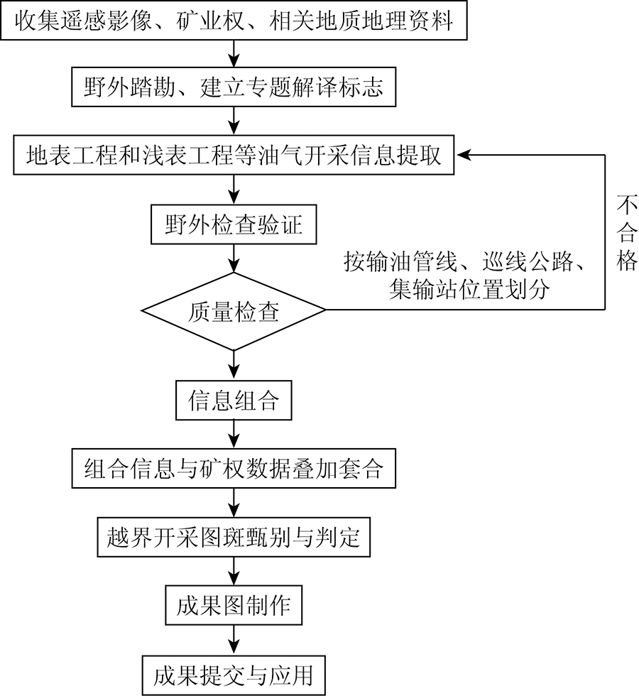
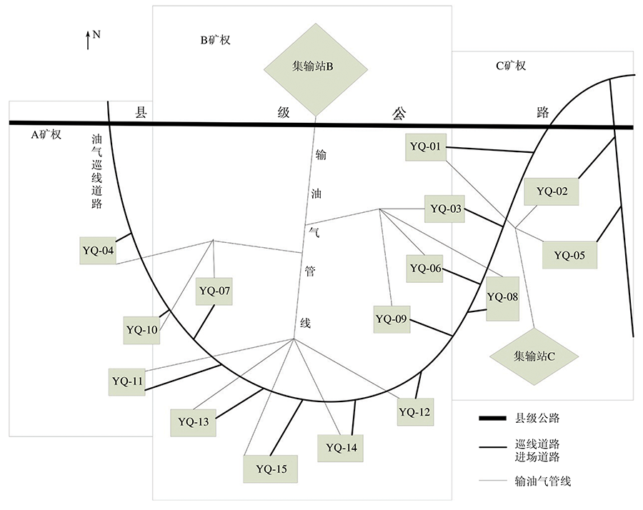
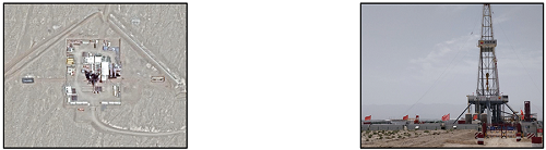
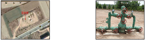
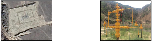
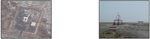
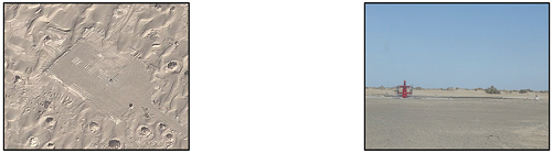
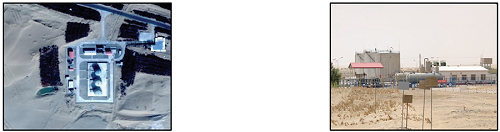
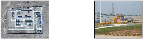
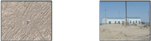
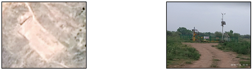
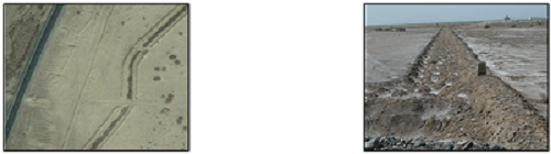
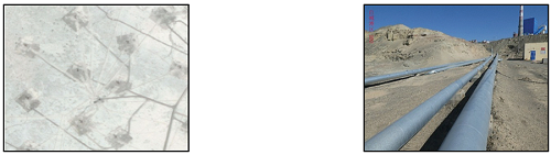
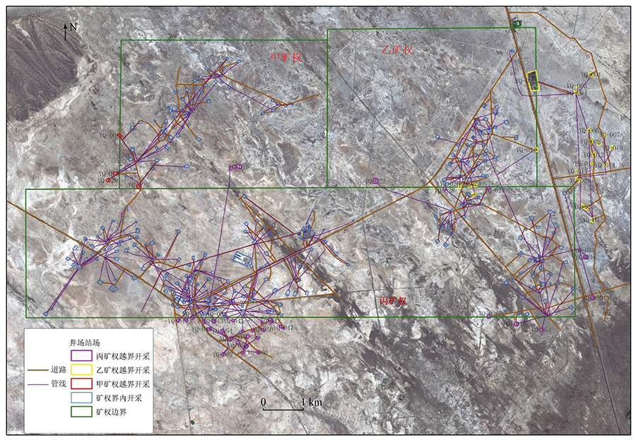
Abstract  

Cross-border mining is a difficult and hot topic in the current supervision of oil and gas mines. Based on the judgement and interpretation of superficial and surface engineering, such as well sites, station sites, oil wells, gas wells, metering plants, gas gathering stations, gathering and transportation stations, patrol roads, and oil and gas pipelines within a single mining right, this study proposed for the first time that the combined information of superficial and surface engineering allow for quickly clarifying the accumulation and flow direction of oil and gas and accurately identifying and determining the production sites belonging to the same mining right and the cross-border sites. This method has been applied to a certain oil field as the test area and has been proved effective.

Keywords oil and gas mines      cross-border mining      GIS      RS     
ZTFLH:  TP79  
Issue Date: 20 June 2022
Service
E-mail this article
E-mail Alert
RSS
Articles by authors
Yuling ZHAO
Jinzhong YANG
Yaqin SUN
Dong CHEN
Cite this article:   
Yuling ZHAO,Jinzhong YANG,Yaqin SUN, et al. A remote sensing method for judging the cross-border mining of oil and gas mines[J]. Remote Sensing for Natural Resources, 2022, 34(2): 30-36.
URL:  
https://www.gtzyyg.com/EN/10.6046/zrzyyg.2021140     OR     https://www.gtzyyg.com/EN/Y2022/V34/I2/30
Fig.1  Flow chart of cross border mining monitoring
Fig.2  Sketch map of oil and gas mine development status on remote sensing interpretation
要素名称 描述 遥感图像 野外照片
游梁式抽油机” “游梁式抽油机”以其“磕头机”的特殊阴影形状在高分影像上容易识别。另外抽油机井场内一般有储油罐和水套炉等配套设备,储油罐在高分影像也容易识别
要素名称 描述 遥感图像 野外照片
非游梁式抽油机 抽油机分布在井场中,影像上为柱状特征,如果太阳角较低时,可以看到较长的拖影。有些井场中还会有其他采油气配套设备
钻井 钻井在遥感影像上分布在方形井场中,表现为高大的塔状物,在高分影像上,钻井的阴影形状清晰可见,非常容易识别。周边有临时简易房、泥浆池和其他钻井附属设备
注水井 注水井在影像上一般与抽油机同时分布在井场,但注水井不太容易识别,表现为一短小的灰黑色图斑,与采油井相比注水井容易被忽略。相较于采油树单侧连接输油管线,注水井两侧均可见输水管线,一侧管线为进水管,一侧管线为出水管。大多数情况下,需要到实地验证才能确认
采天然气井(树) 采气树较“螺杆泵式抽油机”和注水井,目标稍大,在高分影像上一般能显示短小的阴影,其井场通常色调较亮,井场内通常伴有储油气罐等设备,而注水井井场通常没有。一般需要实地验证,来甄别采气井与注水井
影像上,采油井的井场特征较为明显,即井场为水泥硬化,中心有一个方向的台阶,且可见在水泥场地外围有多条间隔的水泥竖条。与废弃的井场的主要区别是在中心点可见凸起及阴影
…… ……
井场 井场一般为规则的矩形或多边形,多为裸土硬化地或砾石硬化地,色调较亮,浅褐黄色,边缘清晰较易识别。井场中有抽油机(采气树)、泥浆池等设施。在该影像中,井场基本上呈矩形,场地内纹理均匀平滑,中间褐色圆点为采油树,与一条较短的线状输油管线相连
集油间(集气站) 在遥感影像上为浅褐黄色,处于平坦的人工场地中,可见较多的矿山建筑,往往多数集输站内置有储油罐(呈圆形凸起),可见到运输车辆
联合站 联合站规模较大,高分影像上,联合站通常呈规则的矩形,色调呈灰黑色,显示水泥硬化面的色调。联合站内设施较复杂,有颜色不同、大小不一的罐体,通常罐体以灰色和绿色为主,灰色为储油罐、绿色为储水罐,不同颜色的罐体是识别联合站的主要标志。另外有分离器等设备
计量间 从影像上看,计量间为呈矩形的小房屋,显著的影像特征为房屋四周可见多条输油管线向房屋处汇聚。在其房屋东侧有一条比较宽的硬化道路
油气区道路 高分影像上采油区道路多为线性特征,长条带形,颜色呈灰黑色或土黄色,显示砾石硬化路面或裸土硬化路面的特征。连接正在开采井场的采油区道路纹理较均匀,色调单一,而连接废弃井场的采油区道路纹理较粗糙,色调杂,显示杂草和砾石、裸土相间的色调
输油气管线 遥感影像上,输油气管线影像特征为平直的线状特征,颜色为浅灰褐色,宽度明显比油气区道路窄。输油气管线从井场开始输出,一般呈鸡爪状或放射状汇聚于计量间或集油间。戈壁地区的埋管一般都会呈明显凸出地表的拱形,影像上可见明显的长条形条带
Tab.1  Interpretation marks of oil and gas mines
Fig.3  Remote sensing interpretation map of cross boundary exploitation of oil and gas mines in the experimental area
[1] 王彧嫣, 樊大磊, 李文博. 2020年国内外油气资源形势分析及展望[J]. 中国矿业, 2021, 30(1):18-23.
[1] Wang Y Y, Fan D L, Li W B. Analysis and outlook of domestic and international oil gas resources situation in 2020[J]. China Mining Magazine, 2021, 30(1):18-23.
[2] 何海清, 范土芝, 郭绪杰, 等. 中国石油“十三五”油气勘探重大成果与“十四五”发展战略[J]. 中国石油勘探, 2021, 26(1):17-30.
[2] He H Q, Fan T Z, Guo X J, et al. Major achivements in oil and gas exploration of PetroChina during the 13th Five-Year Plan period and its development strategy for the 14th Five-Year Plan[J]. China Petroleum Exploration, 2021, 26(1):17-30.
[3] 侯明扬. 世界经济恢复预期拉动全球油气市场回暖[J]. 中国石化, 2021(2):20-23.
[3] Hou M Y. Global oil and gas market rebounds due to world economic recovery expectation[J]. Sinopec Monthly, 2021(2):20-23.
[4] 刘立, 高俊华, 余德清, 等. 矿山越界开采与采矿权面积关系遥感研究[J]. 地理空间信息, 2019, 17(6):47-50,55.
[4] Liu L, Gao J H, Yu D Q, et al. Study on the relationship between mining beyond boundary and mining right area based on remote sensing[J]. Geospatial Information, 2019, 17(6):47-50,55.
[5] 王耿明, 朱俊凤, 王忠忠, 等. 广东省矿山越界开采遥感调查与监测研究[J]. 物探化探计算技术, 2014, 36(4):508-512.
[5] Wang G M, Zhu J F, Wang Z Z, et al. The remote sensing survey and surveillance research of mine exploitation which surpass confines in Guangdong Province[J]. Computing Techniques for Geophysical and Geochemical Exploration, 2014, 36(4):508-512.
[6] 康纪田. 反思与重构越界开采的法律责任[J]. 国土资源科技管理, 2013, 30(1):128-136.
[6] Kang J T. Reflection and reconstruction of legal responsibility of cross-border exploitation[J]. Scientific and Technological Management of Land and Resources, 2013, 30(1):128-136.
[7] 钱新. 越界开采:导致事故的祸根[J]. 安全与健康:上半月, 2008,(10):16-17.
[7] Qian X. Cross border mining:The root cause of accidents[J]. Safety & Health:First half month, 2008,(10):16-17.
[8] 黄鑫, 陈双兰. 矿山越界开采原因分析及对策探讨——以钟山乡为例[J]. 浙江国土资源, 2009(9):39-41.
[8] Huang X, Chen S L. Cause analysis and countermeasures of mine cross boundary mining:Taking Zhongshan Township as an example[J]. Zhejiang Land & Resources, 2009(9):39-41.
[9] 李寿武. 我国油气资源矿权制度中存在的问题及完善对策[J]. 技术经济与管理研究, 2009(2):88-91.
[9] Li S W. Oil-gas property system in China:Problems and solutions[J]. Journal of Technical Economics & Management, 2009(2):88-91.
[10] 罗雪峰. 浙江省矿山越界开采的原因和对策措施[J]. 浙江国土资源, 2014(4):47-49.
[10] Luo X F. Causes and countermeasures of mine cross boundary mining in Zhejiang Province[J]. Zhejiang Land & Resources, 2014(4):47-49.
[11] 赵玉灵, 杨金中, 张志. 油气矿山遥感监测方法初探——以鄂尔多斯盆地为例[J]. 矿产勘查, 2019, 10(12):2980-2989.
[11] Zhao Y L, Yang J Z, Zhang Z. Preliminary study on the remote sensing monitoring of the oil and gas resources:A case study on the Ordos Basin[J]. Mineral Exploration, 2019, 10(12):2980-2989.
[12] 李青, 李任时, 张泽南. 浅谈油气矿山监测[J]. 吉林地质, 2020(4):95-99.
[12] Li Q, Li R S, Zhang Z N. Introduction to the remote sensing monitoring of the oil and gas mines[J]. Jilin Geology, 2020(4):95-99.
[13] 马梓程, 陈思, 帅爽, 等. 遥感技术在油气开发状况调查中的应用[J]. 中国资源综合利用, 2020(10):43-44.
[13] Ma Z C, Chen S, Shuai S, et al. Application of remote sensing technology in investigation of oil and gas developments status[J]. China Resources Comprehensive Utilization, 2020(10):43-44.
[14] 范荣华, 余少华, 李军, 等. 向隐藏大地深处的“毒瘤”开刀——矿山超深越界开采成因及预防对策调研报告[J]. 国土资源导刊, 2012(3):52-54.
[14] Fan R H, Yu S H, Li J, et al. To the “cancer” hidden deep in the earth investigation report on causes and preventive measures of ultra deep and cross boundary mining[J]. Land Resources Herald, 2012(3):52-54.
[15] 王建民, 单玉香. 应用信息化网络技术监测越层越界开采初探[J]. 煤矿安全, 2009(11):105-108.
[15] Wang J M, Shan Y X. Preliminary study on application of information network technology in monitoring cross layer and cross boundary mining[J]. Safety in Coal Mines, 2009(11):105-108.
[16] 董秀成, 董聪, 吴映江. 中国油气矿权:开放与机遇[J]. 能源评论, 2019(12):58-62.
[16] Dong X C, Dong C, Wu Y J. China’s oil and gas mining rights:Opening up and opportunities[J]. Energy Review, 2019(12):58-62.
[1] PARIHA Helili, ZAN Mei. Spatio-temporal changes and influencing factors of ecological environments in oasis cities of arid regions[J]. Remote Sensing for Natural Resources, 2023, 35(3): 201-211.
[2] WANG Jiapeng, XU Jianguo, SHEN Jiaxiao, ZHANG Dengrong. Evaluating the remediation effect of heavy metal pollution in the Dexing copper mine based on hyperspectral remote sensing[J]. Remote Sensing for Natural Resources, 2023, 35(3): 284-291.
[3] YU Hang, AN Na, WANG Jie, XING Yu, XU Wenjia, BU Fan, WANG Xiaohong, YANG Jinzhong. High-resolution remote sensing-based dynamic monitoring of coal mine collapse areas in southwestern Guizhou: A case study of coal mine collapse areas in Liupanshui City[J]. Remote Sensing for Natural Resources, 2023, 35(3): 310-318.
[4] LI Zhixin, WANG Mengfei, JIA Weijie, JI Song, WANG Yufei. A method for identifying the number of building floors based on shadow information[J]. Remote Sensing for Natural Resources, 2023, 35(3): 97-106.
[5] WANG Zhenhua, TAN Zhilian, LI Jing, CHANG Yingli. Re-YOLOX: A YOLOX model for identifying nearshore monitoring targets improved based on the Resizer model[J]. Remote Sensing for Natural Resources, 2023, 35(3): 10-16.
[6] ZHONG Le, ZENG Yan, QIU Xinfa, SHI Guoping. Suitability regionalization of Myrica rubra planting in Zhejiang Province[J]. Remote Sensing for Natural Resources, 2023, 35(2): 236-244.
[7] ZHU Boqin, YAN Zhaojin, XIE Jing, LIU Hong, SONG Xiaoqing, XIANG Xiqiong. Key technology for selecting depressions as sites of FAST-type radio telescopes[J]. Remote Sensing for Natural Resources, 2023, 35(2): 80-88.
[8] DIAO Mingguang, LIU Yong, GUO Ningbo, LI Wenji, JIANG Jikang, WANG Yunxiao. Mask R-CNN-based intelligent identification of sparse woods from remote sensing images[J]. Remote Sensing for Natural Resources, 2023, 35(2): 97-104.
[9] ZHENG Zongsheng, LIU Haixia, WANG Zhenhua, LU Peng, SHEN Xukun, TANG Pengfei. Improved 3D-CNN-based method for surface feature classification using hyperspectral images[J]. Remote Sensing for Natural Resources, 2023, 35(2): 105-111.
[10] LYU Yongqiang, YU Xinwei, YANG Shuo, ZHENG Xinqi. Identification of the polycentric urban structure based on multi-source geographic big data[J]. Remote Sensing for Natural Resources, 2023, 35(2): 132-139.
[11] ZHANG Guojian, LIU Shengzhen, SUN Yingjun, YU Kaijie, LIU Lina. Hyperspectral anomaly detection based on the weakly supervised robust autoencoder[J]. Remote Sensing for Natural Resources, 2023, 35(2): 167-175.
[12] HUANG Xiaoyu, WANG Xuemei, KAWUQIATI Baishan. Inversion of soil salinity of an oasis in an arid area based on Landsat8 OLI images[J]. Remote Sensing for Natural Resources, 2023, 35(1): 189-197.
[13] ZHANG Zhenqi, CAI Huiwen, ZHANG Pingping, WANG Zelin, LI Tingting. A GEE-based study on the temporal and spatial variations in the carbon source/sink function of vegetation in the Three-River Headwaters region[J]. Remote Sensing for Natural Resources, 2023, 35(1): 231-242.
[14] KONG Zhuo, YANG Haitao, ZHENG Fengjie, LI Yang, QI Ji, ZHU Qinyu, YANG Zhonglin. Research advances in atmospheric correction of hyperspectral remote sensing images[J]. Remote Sensing for Natural Resources, 2022, 34(4): 1-10.
[15] WANG Yu, ZHOU Zhongfa, WANG Lingyu, LUO Jiancheng, HUANG Denghong, ZHANG Wenhui. Sentinel-1-based spatial differentiation study of the planting structures in Karst plateau mountainous areas[J]. Remote Sensing for Natural Resources, 2022, 34(4): 155-165.
Viewed
Full text


Abstract

Cited

  Shared   
  Discussed   
京ICP备05055290号-2
Copyright © 2017 Remote Sensing for Natural Resources
Support by Beijing Magtech