|
|
|
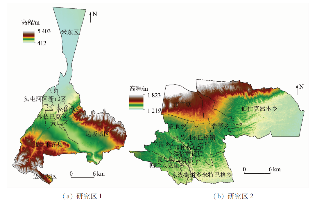
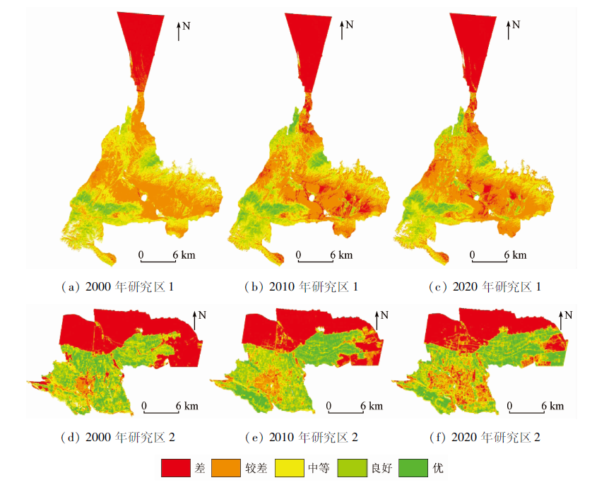
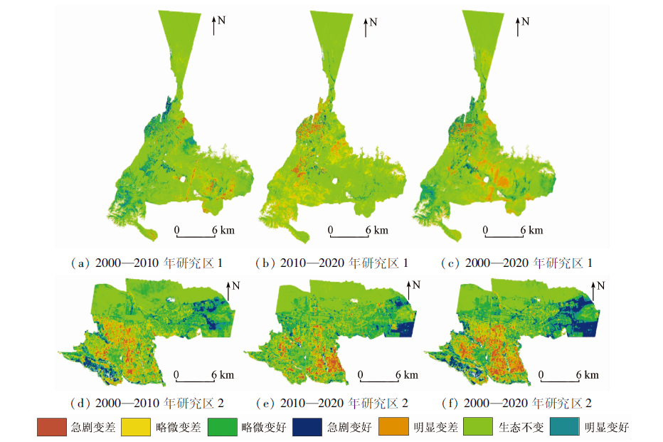
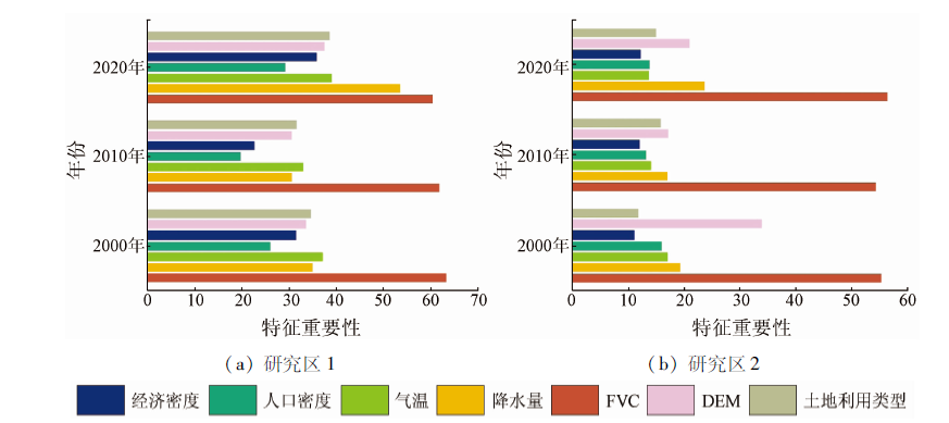
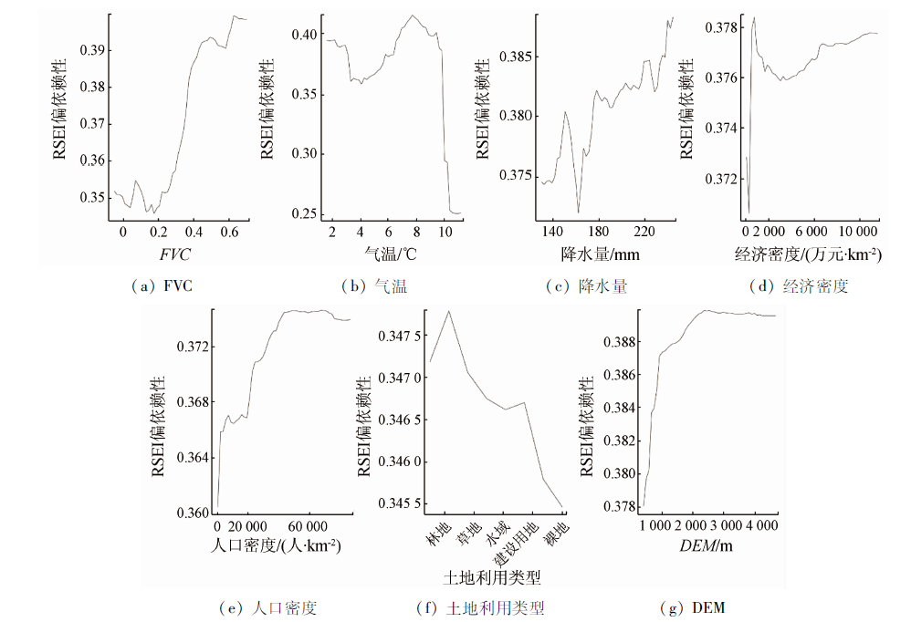
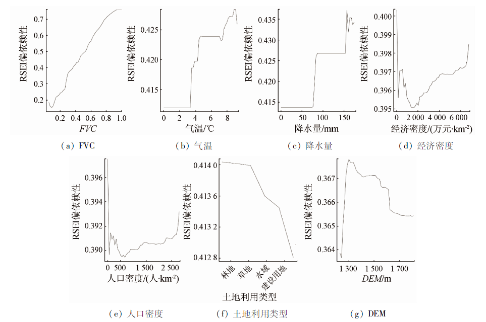
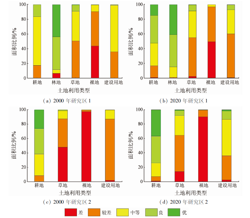
Abstract Cities are core areas for human life and production. The ecological environment quality is a growing concern in cities, especially cities with fragile ecological environments in arid regions. This study selected 2 study areas from two typical oasis cities, namely Urumqi City in northern Xinjiang and Kashgar City in southern Xinjiang. It compared the spatio-temporal changes in the ecological environment quality of the two study areas in 2000, 2010, and 2020 using two urban remote sensing-based ecological indices (RSEIs) constructed based on the Google Earth Engine (GEE). Furthermore, it quantitatively analyzed the factors influencing the RESIs of the two cities using the random forest model. The results are as follows: ① Over the past 20 years, the ecological environment quality in study area 1 worsened but that in study area 2 improved overall. In study area 1, the ecological environment improved mainly in the old urban area and deteriorated in the newly built area at the periphery of the urban area. In study area 2, the ecological environment significantly improved in the northeastern part and deteriorated in the newly built area around the city center. ② The fractional vegetation cover is the most critical factor influencing RESIs of both study areas, followed by temperature and precipitation. These influencing factors had different influences on the RSEIs of the two study areas. ③ The primary reasons for the deterioration of the ecological environment in study area 1 included the expanded urban scale, the increased impervious surfaces, and the decreased fractional vegetation cover in the past 20 years are. In contrast, urbanization and green and healthy urban development pattern jointly played a significant role in improving the ecological environment quality in study area 2. The results of this study can provide a scientific basis for healthy urban development in both study areas.
|
| Keywords
Urumqi City
Kashgar City
RSEI
GEE
random forest
|
|
|
|
Issue Date: 19 September 2023
|
|
|
| [1] |
王东升, 王小磊, 雷泽勇. 基于遥感生态指数的阜新市生态质量评估[J]. 生态科学, 2020, 39(3):88-94.
|
| [1] |
Wang D S, Wang X L, Lei Z Y. Ecological change assessment of Fuxin based on remote sensing ecological index[J]. Ecological Science, 2020, 39(3):88-94.
|
| [2] |
Ochoa-Gaona S, Kampichler C, De Jong B H J, et al. Amulti-criteri on index for the evaluation of local tropical forest conditions in Mexico[J]. Forest Ecology Management, 2010, 260:618-627.
doi: 10.1016/j.foreco.2010.05.018
url: https://linkinghub.elsevier.com/retrieve/pii/S0378112710002756
|
| [3] |
张瑞钢, 莫兴国, 林忠辉. 滹沱河上游山区近50年蒸散变化及主要影响因子分析[J]. 地理科学, 2012, 32(5):628-634.
doi: 10.13249/j.cnki.sgs.2012.05.628
|
| [3] |
Zhang R G, Mo X G, Lin Z H. The trend and the principal influence factors of evapotranspiration in Hutuo River basin during last 50 years[J]. Journal of Geophysical Research, 2012, 32(5):628-634.
|
| [4] |
徐涵秋. 城市遥感生态指数的创建及其应用[J]. 生态学报, 2013, 33(24):7853-7862.
|
| [4] |
Xu H Q. A remote sensing urban ecological index and its application[J]. Acta Ecologica Sinica, 2013, 33(24):7853-7862.
|
| [5] |
朱泓, 王金亮, 程峰, 等. 滇中湖泊流域生态环境质量监测与评价[J]. 应用生态学报, 2020, 31(4):1289-1297.
doi: 10.13287/j.1001-9332.202004.011
|
| [5] |
Zhu H, Wang J L, Cheng F, et al. Monitoring and evaluation of eco-environmental quality of lake basin regions in central Yunnan Province,China[J]. Chinese Journal of Applied Ecology, 2020, 31(4):1289-1297.
|
| [6] |
蒋超亮, 吴玲, 刘丹, 等. 干旱荒漠区生态环境质量遥感动态监测——以古尔班通古特沙漠为例[J]. 应用生态学报, 2019, 30(3):877-883.
doi: 10.13287/j.1001-9332.201903.008
|
| [6] |
Jiang C L, Wu L, Liu D, et al. Dynamic monitoring of eco-environmental quality in arid desert area by remote sensing:Taking the Gurbantunggut Desert China as an example[J]. Chinese Journal of Applied Ecology, 2019, 30(3):877-883.
|
| [7] |
Karbalaei S S, Amoushahi S, Gholipour M. Spatiotemporal ecological quality assessment of metropolitan cities:A case study of central Iran[J]. Environmental Monitoring and Assessment, 2021, 193(5):305-305.
doi: 10.1007/s10661-021-09082-2
pmid: 33900465
|
| [8] |
张亚球, 姜放, 纪梦达, 等. 基于遥感指数的区县级生态环境评价[J]. 干旱区研究, 2020, 37(6):1598-1605.
|
| [8] |
Zhang Y Q, Jiang F, Ji M D, et al. Assessment of the ecological environment at district and county level based on remote sensing index[J]. Arid Zone Research, 2020, 37(6):1598-1605.
|
| [9] |
刘立冰, 熊康宁, 任晓冬. 基于遥感生态指数的龙溪—虹口国家级自然保护区生态环境状况评估[J]. 生态与农村环境学报, 2020, 36(2):202-210.
|
| [9] |
Liu L B, Xiong K N, Ren X D. Assessment of ecological environment status in the Longxi-Hongkou National Nature Reserve based on remote sensing ecological index[J]. Journal of Ecology and Rural Environment, 2020, 36(2):202-210.
|
| [10] |
万虹麟, 霍飞, 牛玉芬, 等. 顾及PM2.5浓度遥感生态指数模型的沧州市区生态环境质量动态监测分析[J]. 地球物理学进展, 2021, 36(3):953-960.
|
| [10] |
Wan H L, Huo F, Niu Y F, et al. Dynamic monitoring and analysis of ecological environment change in Cangzhou City based on RSEI model considering PM2.5 concentration[J]. Progress in Geophysics, 2021, 36(3):953-960.
|
| [11] |
郑子豪, 吴志峰, 陈颖彪, 等. 基于Google Earth Engine的长三角城市群生态环境变化与城市化特征分析[J]. 生态学报, 2021, 41(2):717-729.
|
| [11] |
Zheng Z H, Wu Z F, Chen Y B, et al. Analyzing the ecological environment and urbanization characteristics of the Yangtze River Delta Urban Agglomeration based on Google Earth Engine[J]. Acta Ecologica Sinica, 2021, 41(2):717-729.
|
| [12] |
杭鑫, 罗晓春, 曹云, 等. 基于RSEI模型的生态质量评估及城镇化影响——以南京市为例[J]. 应用生态学报, 2020, 31(1):219-229.
doi: 10.13287/j.1001-9332.202001.030
|
| [12] |
Hang X, Luo X C, Cao Y, et al. Ecological quality assessment and the impact of urbanization based on RSEI model for Nanjing,Jiangsu Province,China[J]. Chinese Journal of Applied Ecology, 2020, 31(1):219-229.
|
| [13] |
李婷婷, 马超, 郭增长. 基于RSEI模型的贺兰山长时序生态质量评价及影响因素分析[J]. 生态学杂志, 2021, 40(4):1154-1165.
|
| [13] |
Li T T, Ma C, Guo Z C. Ecological quality evaluation and influencing factors analysis of Helan Mountain based on RSEI[J]. Chinese Journal of Ecology, 2021, 40(4):1154-1165.
|
| [14] |
张华, 宋金岳, 李明, 等. 基于GEE的祁连山国家公园生态环境质量评价及成因分析[J]. 生态学杂志, 2021, 40(6):1883-1894.
|
| [14] |
Zhang H, Song J Y, Li M, et al. Eco-environmental quality assessment of Qilian Mountain National Park based on GEE[J]. Chinese Journal of Ecology, 2021, 40(6):1883-1894.
|
| [15] |
约日古丽·卡斯木, 孜比布拉·司马义, 王蕾, 等. 新疆博乐市生态环境变化对城市建设用地扩张的响应[J]. 农业工程学报, 2019, 35(1):252-259.
|
| [15] |
Yueriguli K, Zibibula S, Wang L, et al. Response of ecological environment change to urban construction land expansion in Bole City of Xinjiang[J]. Transactions of the Chinese Society of Agricultural Engineering, 2019, 35(1):252-259.
|
| [16] |
Xiong Y, Xu W, Lu N, et al. Assessment of spatial-temporal changes of ecological environment quality based on RSEI and GEE:A case study in Erhai Lake basin,Yunnan Province,China[J]. Ecological Indicators, 2021, 125:107518.
doi: 10.1016/j.ecolind.2021.107518
url: https://linkinghub.elsevier.com/retrieve/pii/S1470160X21001837
|
| [17] |
韩芹芹, 张克潭. 乌鲁木齐市环境应急监测体系存在的问题及对策[J]. 中国环境监测, 2013, 29(2):86-90.
|
| [17] |
Han Q Q, Zhang K T. The Study on problems and countermeasures of environmental emergency monitoring system in Urumqi[J]. Environmental Monitoring in China, 2013, 29(2):86-90.
|
| [18] |
阿力木江·塔依尔, 木合塔尔·艾买提. 城市化与干旱区环境耦合度分析——以喀什市为例[J]. 环境影响评价, 2016, 38(4):92-96.
|
| [18] |
Alimjan T, Muhetaer A. Analysis on coupling degree between urbanization and arid area:Taking Kashi City as an example[J]. Environmental Impact Assessment, 2016, 38(4):92- 96.
|
| [19] |
哈孜亚·包浪提将, 毋兆鹏, 陈学刚, 等. 乌鲁木齐市景观格局变化及驱动力分析[J]. 生态科学, 2018, 37(1):62-70.
|
| [19] |
Haziya B, Wu Z P, Chen X G, et al. Analysis of landscape pattern change and driving force in Urumqi City[J]. Ecological Science, 2018, 37(1):62-70.
|
| [20] |
王志杰, 苏嫄. 南水北调中线汉中市水源地生态脆弱性评价与特征分析[J]. 生态学报, 2018, 38(2):432-442.
|
| [20] |
Wang Z J, Su Y. Analysis of eco-environmental vulnerability characteristics of Hanzhong City,near the water source midway along the route of the South-to-North Water Transfer Project,China[J]. Acta Ecological Sinica, 2018, 38(2):432-442.
|
| [21] |
Xu H. A new index for delineating built-up land features in satellite imagery[J]. International Journal of Remote Sensing, 2008, 29(14):4269-4276.
doi: 10.1080/01431160802039957
url: https://www.tandfonline.com/doi/full/10.1080/01431160802039957
|
| [22] |
徐涵秋. 水土流失区生态变化的遥感评估[J]. 农业工程学报, 2013, 29(7):91-97,294.
|
| [22] |
Xu H Q. Remote sensing assessment of ecological changes in soil and water loss areas[J]. Transactions of the Chinese Society of Agricultural Engineering, 2013, 29(7):91- 97,294.
|
| [23] |
Jiménez-Muoz J C, Sobrino J A. A generalized single-channel method for retrieving land surface temperature from remote sensing data[J]. Journal of Geophysical Research Atmospheres, 2003, 108(22):4688.
|
| [24] |
Breiman L. Random forests[J]. Machine Learning, 2001, 45 (1):5-32.
doi: 10.1023/A:1010933404324
url: http://link.springer.com/10.1023/A:1010933404324
|
| [25] |
陈兵红, 靳全锋, 柴红玲, 等. 浙江省大气PM2.5时空分布及相关因子分析[J]. 环境科学学报, 2021, 41(3):817-829.
|
| [25] |
Chen B H, Jin Q F, Chai H L, et al. Spatiotemporal distribution and correlation factors of PM2.5 concentrations in Zhejiang Province[J]. Acta Scientiae Circumstantiae, 2021, 41(3):817-829.
|
| [26] |
张文强, 罗格平, 郑宏伟, 等. 基于随机森林模型的内陆干旱区植被指数变化与驱动力分析:以北天山北坡中段为例[J]. 植物生态学报, 2020, 44(11):1113-1126.
|
| [26] |
Zhang W Q, Luo G P, Zheng H W, et al. Analysis of vegetation index changes and driving forces in inland arid areas based on random forest model:A case study of the middle part of northern slope of the north Tianshan Mountains[J]. Chinese Journal of Plant Ecology, 2020, 44(11):1113-1126.
doi: 10.17521/cjpe.2020.0111
url: https://www.plant-ecology.com/EN/10.17521/cjpe.2020.0111
|
| [27] |
赖自力, 向杰, 陈建平, 等. 基于随机森林模型的云南元阳梯田地形因子分析[J]. 地质学刊, 2016, 40(3):518-525.
|
| [27] |
Lai Z L, Xiang J, Chen J P, et al. Analysis on topographic factors of the Yuanyang terrace in Yunnan Province based on random forest model[J]. Journal of Geology, 2016, 40(3):518-525.
|
| [28] |
杨保华, 杨清华, 陈剑虹. 关于《生态环境状况评价技术规范(试行)》中土地退化指数的权重及计算方法的探讨[J]. 生态与农村环境学报, 2011, 27(3):103-107.
|
| [28] |
Yang B H, Yang Q H, Chen J H. Weight of land (soil) degradation indeces and optimization of their calculation in “echnical criteria or evaluation of ecological environment (Trial)”[J]. Journal of Ecology and Rural Environment, 2011, 27(3):103-107.
|
| [29] |
刘盼, 任春颖, 王宗明, 等. 南瓮河自然保护区生态环境质量遥感评价[J]. 应用生态学报, 2018, 29(10):3347-3356.
|
| [29] |
Liu P, Ren C Y, Wang Z M, et al. Assessment of the eco-environmental quality in the Nanweng River Nature Reserve,Northeast China by remote sensing[J]. Chinese Journal of Applied Ecology, 2018, 29(10):3347-3356.
|
| [30] |
Guidotti R, Monreale A, Ruggieri S, et al. A survey of methods for explaining black box models[J]. ACM Computing Surveys, 2018, 51(5):1-42.
|
| [31] |
哈尚辰, 阿里木江·卡斯木. 近20年来喀什市乡村转型发展评价[J]. 水土保持通报, 2016, 36(6):282-287.
|
| [31] |
Ha S C, Alimujiang K. Evaluation of rural transformation development in Kashgar City during last 20 years[J]. Bulletin of Soil and Water Conservation, 2016, 36(6):282-287.
|
| [32] |
Liu C, Yang M H, Hou Y T, et al. Spatiotemporal evolution of island ecological quality under different urban densities:A comparative analysis of Xiamen and Kinmen Islands,Southeast China[J]. Ecological Indicators, 2021, 124:107438.
doi: 10.1016/j.ecolind.2021.107438
url: https://linkinghub.elsevier.com/retrieve/pii/S1470160X21001035
|
|
Viewed |
|
|
|
Full text
|
|
|
|
|
Abstract
|
|
|
|
|
Cited |
|
|
|
|
| |
Shared |
|
|
|
|
| |
Discussed |
|
|
|
|
 2023,
Vol. 35
2023,
Vol. 35
 ), ZAN Mei1,2(