|
|
 |
|

|
|
|
Methods for the application of topography and NDVI in re-identification of remote sensing-based monitoring of forest fires |
CHEN Yanying1( ), MA Xincheng2(), XU Yanping3, WANG Ying4, WANG Yanbo5 ), MA Xincheng2(), XU Yanping3, WANG Ying4, WANG Yanbo5 |
1. Chongqing Institute of Meteorological Sciences, Chongqing 401147, China
2. CCCC Highway Consultants Co., Ltd., Beijing 100010, China
3. Kaizhou District Release Center of Emergency and Early Warning Information in Chongqing, Chongqing 405400, China
4. Jiangjin Modern Agricultural Meteorological Trial Station in Chongqing City, Chongqing 402260, China
5. Chaoyang Teachers College, Chaoyang 122000, China |
|
|
|
|
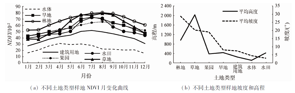
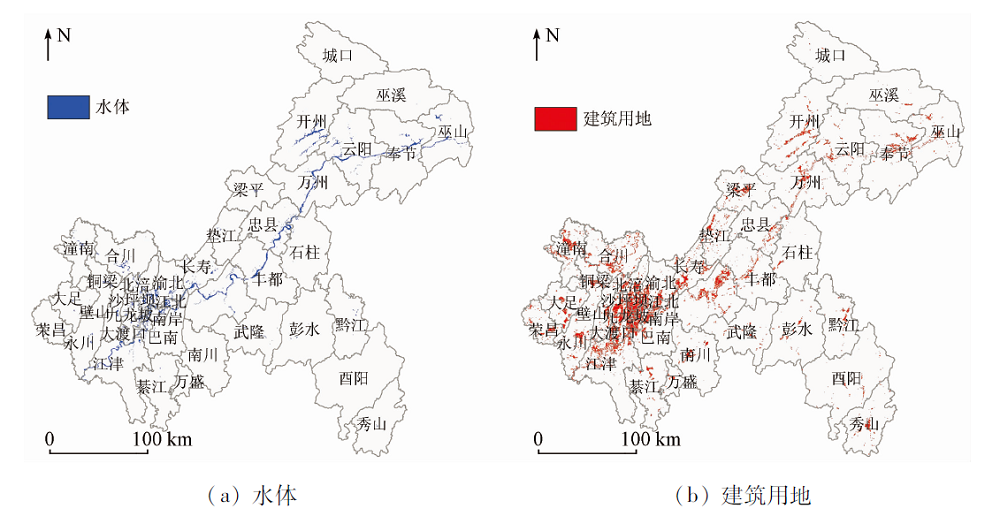
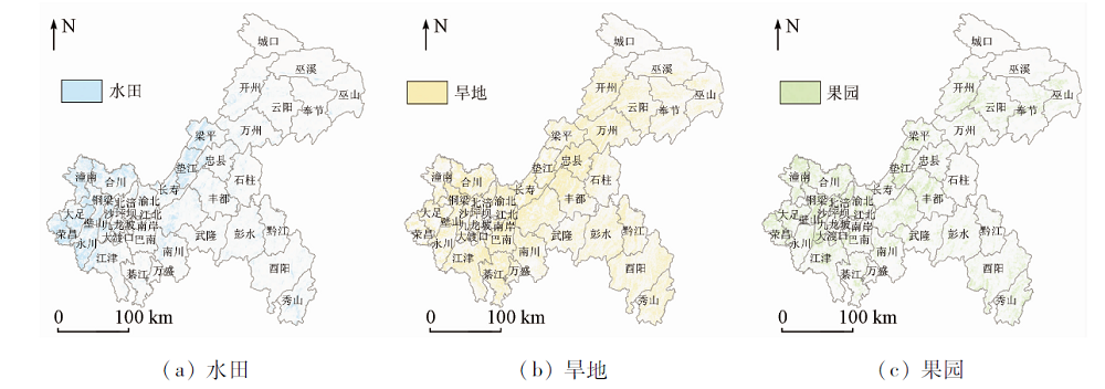
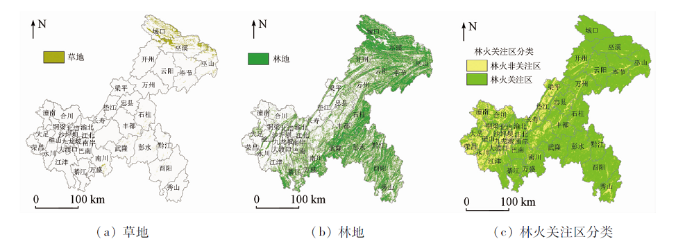
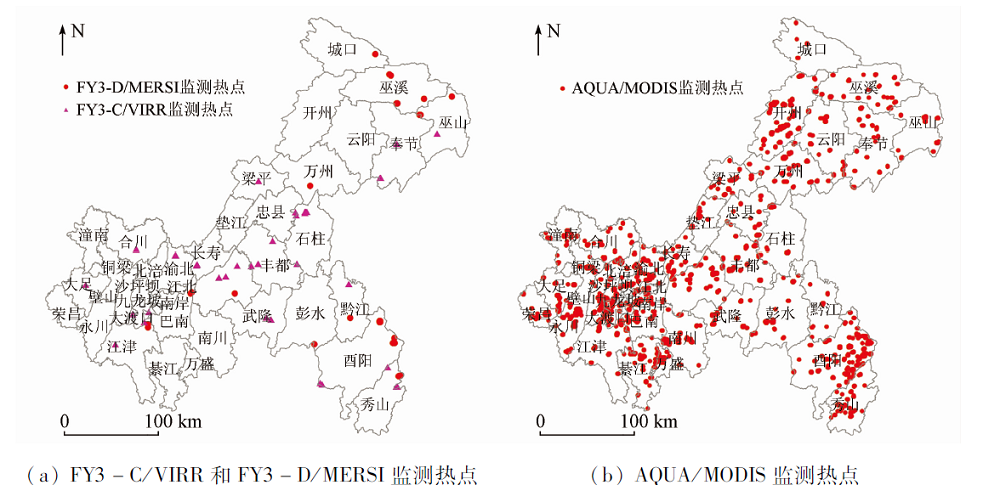
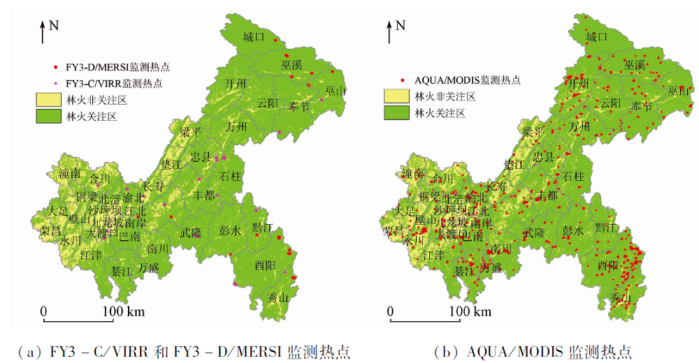
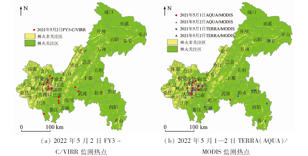
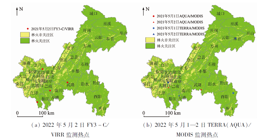
Abstract The indicative significance of normalized vegetation index (NDVI) and terrain factors in land classification can be applied to specific scenarios. This study extracted the land classification information of Chongqing using the AQUA/MODIS NDVI and terrain indices (height and slope) of 2002—2020 and accordingly divided the land in Chongqing into seven types, i.e., forest land, grassland, orchard, dry fields, paddy fields, waters, and residential and building land, with the former three types being economic forest land. Based on the characteristics of broken terrain caused by the staggered distribution of agricultural, forest, and grassland, as well as the need for fire prevention in Chongqing, this study categorized the economic forest land and dry fields as concern areas of forest fires and categorized paddy fields, waters, and residential and building land as unconcerned areas of forest fires. The hotspots monitored using AQUA/MODIS in 2002—2020, FY3-C/VIRR in 2014—2020, and FY3-D/MERSI in 2019—2020 individually were re-identified based on the classification results of the concern areas of forest fires. The results are as follows. The extraction accuracy of individual land types (except for orchard and dry fields) was over 64%, and that of the concern areas of forest fires was over 86%. Based on the classification results of concern areas of forest fires, the forest fire points monitored using the remote sensing techniques were re-identified. The re-identification results showed that the 46.27%, 26.47%, and 11.76% of forest fire points monitored using AQUA/MODIS, FY3-C/VIRR, and FY3-D/MERSI, respectively were in unconcerned areas of forest fires. The forest fires monitored using remote sensing techniques on May 1-2, 2021 were re-identified, and 71.4%and 81.08% of forest fire points monitored using FY3-C/VIRR and both AQUA/MODIS and TERRA/MODIS, respectively were in unconcerned areas of forest fires. Therefore, extracting land classification information in complex terrain areas using NDVI and terrain indices and applying the extraction results to the re-identification of forest fires monitored using remote sensing techniques can effectively reduce the interference to forest fire monitoring in complex terrain areas, thereby minimizing the input of manpower and properties for the verification of hotspots.
|
| Keywords
NDVI
terrain index
forest fire
remote sensing and monitoring
re-identification
|
|
|
|
Corresponding Authors:
MA Xincheng
E-mail: chenyanying1618@163.com;maxincheng@hpdi.com.cn
|
|
Issue Date: 21 September 2022
|
|
|
| [1] |
张剑. 林火监测与预警在森林防灭火中的运用[J]. 林业科技, 2021(2):165-166.
|
| [1] |
Zhang J. Application of forest fire monitoring and early warning in forest fire prevention[J]. Forestry Technology, 2021(2):165-166.
|
| [2] |
覃先林, 李晓彤, 刘树超, 等. 中国林火卫星遥感预警监测技术研究进展[J]. 遥感学报, 2020, 24(5):511-520.
|
| [2] |
Qin X L, Li X T, Liu S C, et al. Forest fire early warning and monitoring techniques using satellite remote sensing in China[J]. Journal of Remote Sensing, 2020, 24(5):511-520.
|
| [3] |
周利霞, 高光明, 邱冬生. 基于MODIS数据的火点监测指数方法研究[J]. 火灾科学, 2008, 17(2):77-82.
|
| [3] |
Zhou L X, Gao G M, Qiu D S. Fire-monitoring method of FPI-NDVI based on MODIS data[J]. Fire Safety Science, 2008, 17(2):77-82.
|
| [4] |
马芮, 孙林, 袁广辉, 等. 可见光红外成像辐射仪数据林火识别算法研究[J]. 遥感信息, 2015, 30(4):37-42.
|
| [4] |
Ma R, Sun L, Yuan G H, et al. Technology and method of forest fire monitoring using NPP VIIRS data[J]. Remote Sensing Information, 2015, 30(4):37-42.
|
| [5] |
覃先林, 易浩若. 基于MODIS数据的林火识别方法研究[J]. 火灾科学, 2004, 13(2):83-89.
|
| [5] |
Qin X L, Yi H R. A method to identify forest fire based on MODIS data[J]. Fire Safety Science, 2004, 13(2):83-89.
|
| [6] |
张婕, 张文煜, 冯建东, 等. 基于亮温-植被指数-气溶胶光学厚度的MODIS火点监测算法研究[J]. 遥感技术与应用, 2016, 31(5):886-892.
|
| [6] |
Zhang J, Zhang W Y, Feng J D, et al. An improved algorithm for forest fire detection:A study based on brightness temperature, vegetation index and AOD[J]. Remote Sensing Technology and Application, 2016, 31(5):886-892.
|
| [7] |
饶月明, 王川, 黄华国. 联合多源遥感数据监测四川木里县森林火灾[J]. 遥感学报, 2020, 24(5):559-570.
|
| [7] |
Rao Y M, Wang H, Huang H G. Forest fire monitoring based on multisensor remote sensing techniques in Muli County,Sichuan Province[J]. Journal of Remote Sensing, 2020, 24(5):559-570.
|
| [8] |
Kaufman Y J, Tucker Q, Fung L. Remote sensing of biomass burning in the tropics[J]. Journal of Geophysical Research, 1990, 95:9927-9939.
doi: 10.1029/JD095iD07p09927
url: http://doi.wiley.com/10.1029/JD095iD07p09927
|
| [9] |
Giglio L, Descloites J, Justice C, et al. An enhanced contextual fire detection algorithm for MODIS[J]. Remote Sensing of Environment, 2003, 87(2/3):273-282.
doi: 10.1016/S0034-4257(03)00184-6
url: https://linkinghub.elsevier.com/retrieve/pii/S0034425703001846
|
| [10] |
陈兴峰, 刘李, 李家国, 等. 卫星遥感火点监测应用和研究进展[J]. 遥感学报, 2020, 24(5):531-542.
|
| [10] |
Chen X F, Liu L, Li J G, et al. Application and research progress of fire monitoring using satellite remote sensing[J]. Journal of Remote Sensing, 2020, 24(5):531-542.
|
| [11] |
胡梅, 齐述华, 舒晓波, 等. 华北平原秸秆焚烧火点的MODIS影像识别监测[J]. 地球信息科学, 2008, 10(6):802-807.
|
| [11] |
Hu M, Qi S H, Shu X B, et al. Monitoring fire from crop residues burning with MODIS data in north China plain[J]. Geo-Information Science, 2008, 10(6):802-807.
|
| [12] |
陈艳英, 游扬声, 何正明, 等. 重庆市森林火灾时空分布特征分析[J]. 中国农学通报, 2014, 30(13):51-58.
|
| [12] |
Chen Y Y, You Y S, He Z M, et al. Analysis on temporal-spatial feature of forest fires in Chongqing[J]. Chinese Agricultural Science Bulletin, 2014, 30(13):51-58.
|
| [13] |
陈艳英, 游扬声, 唐云辉. 局域地形和林火数量对区划方法的影响规律研究[J]. 自然灾害学报, 2015, 24(2):228-234.
|
| [13] |
Chen Y Y, You Y S, Tang Y H. Research of forest fire zoning based on local topography and fire numbers[J]. Journal of Natural Disaters, 2015, 24(2):228-234.
|
| [14] |
李伶俐, 李江文, 钟守琴, 等. 基于地形复杂度的重庆市耕地“宜机化”改造适宜性评价[J]. 中国生态农业学报(中英文), 2022, 30(2):302-313.
|
| [14] |
Li L L, Li J W, Zhong S Q, et al. Suitability evaluation of suitable-for-mechanization transformation of cultivated land based on topographic complexity in Chongqing,China[J]. Chinese Journal of Eco-Agriculture, 2022, 30(2):302-313.
|
| [15] |
毛玉龙. 第三次国土调查对耕地的调查和认定[J]. 西部资源, 2021(6):166-168.
|
| [15] |
Mao Y L. Investigation and identification of cultivated land in the third national land survey[J]. Western Resources, 2021(6):166-168.
|
|
Viewed |
|
|
|
Full text
|
|
|
|
|
Abstract
|
|
|
|
|
Cited |
|
|
|
|
| |
Shared |
|
|
|
|
| |
Discussed |
|
|
|
|
 2022,
Vol. 34
2022,
Vol. 34