|
|
 |
|

|
|
|
Application of multi-scale and lightweight CNN in SAR image-based surface feature classification |
SUN Sheng1( ), MENG Zhimin1, HU Zhongwen2, YU Xu3 ), MENG Zhimin1, HU Zhongwen2, YU Xu3 |
1. School of Computer Science and Technology, Guangdong University of Technology, Guangzhou 510006, China
2. Key Laboratory for Geo-Environmental Monitoring of Great Bay Area, Ministry of Natural Rresources, Shenzhen University, Shenzhen 518000, China
3. School of Civil and Transportation Engineering,Guangdong University of Technology, Guangzhou 510006, China |
|
|
|
|
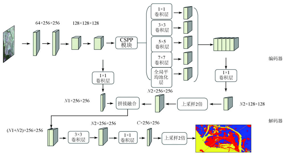
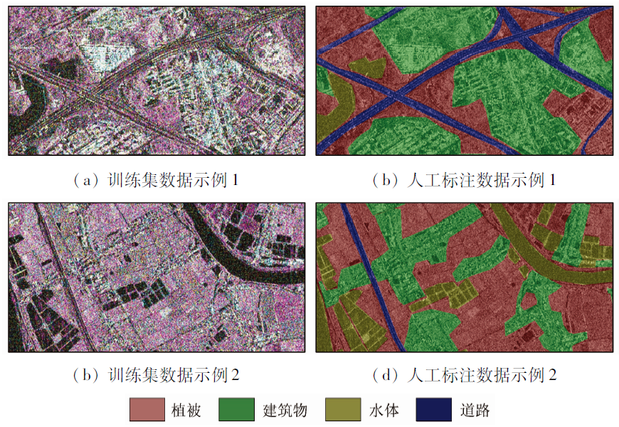
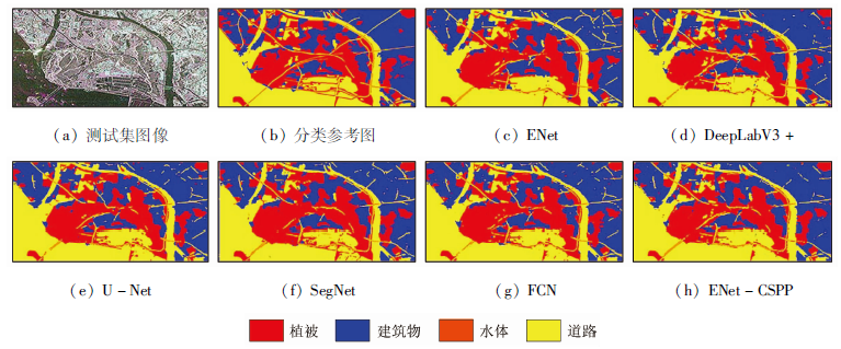
Abstract Targeting the subtropical climate characteristics of the Guangdong-Hong Kong-Macao Greater Bay Area, this study acquired the images of the experimental area from the TerraSAR-X Radar remote sensing satellite. Given the varying scale of the surface feature targets in the Radar satellite observation scenes, this study proposed an ENet convolution spatial pyramid pooling module (ENet-CSPP) model for surface feature classification. Since ordinary convolution can more effectively maintain domain information than atrous convolution, this study proposed a multi-scale feature fusion module based on convolution spatial pyramid pooling. Since there were a few training samples in the SAR remote sensing image dataset, this study combined the multi-scale feature fusion module with the lightweight convolutional neural network. The encoder of the ENet-CSPP network consisted of an improved ENet network and the convolution spatial pyramid pooling module. The decoder output surface feature classification images after the fusion of deep and shallow features. The quantitative comparison experiments were conducted on the GDUT-Nansha dataset. The ENet-CSPP model outperformed other models in three performance indices, namely pixel accuracy, average pixel accuracy, and mean intersection over union. This result indicates that the multi-scale lightweight model effectively improved the accuracy of surface feature classification.
|
| Keywords
synthetic aperture Radar(SAR)
surface feature classification
convolutional neural network
lightweight network
|
|
|
|
Issue Date: 20 March 2023
|
|
|
| [1] |
吕启, 窦勇, 牛新, 等. 基于DBN模型的遥感图像分类[J]. 计算机研究与发展, 2014, 51(9):1911-1918.
|
| [1] |
Lyu Q, Dou Y, Niu X, et al. Remote sensing image classification based on DBN model[J]. Journal of Computer Research and Development, 2014, 51(9):1911-1918.
|
| [2] |
高照忠, 魏海霞, 黄铁兰. 粤港澳大湾区土地覆盖及景观格局时空变化分析[J]. 测绘通报, 2021(5):25-29.
|
| [2] |
Gao Z Z, Wei H X, Huang T L. Analysis of spatio-temporal changes of land cover and landscape pattern in Guangdong-Hong Kong-Macao Greater Bay Area[J]. Bulletin of Surveying and Mapping, 2021(5):25-29.
|
| [3] |
van Zyl J J, Kim Y. Synthetic aperture Radar polarimetry[M]. Hoboken:Wiley, 2011:3.
|
| [4] |
Yao W, Marmanis D, Datcu M. Semantic segmentation using deep neural networks for SAR and optical image pairs[C]// Big Data From Space, 2017:1-4.
|
| [5] |
Long J, Shelhamer E, Darrell T. Fully convolutional networks for semantic segmentation[J]. IEEE Transactions on Pattern Analysis and Machine Intelligence, 2017, 39(4):640-650.
doi: 10.1109/TPAMI.2016.2572683
pmid: 27244717
|
| [6] |
Henry C, Azimi S M, Merkle N. Road segmentation in SAR satellite images with deep fully convolutional neural networks[J]. IEEE Geoscience and Remote Sensing Letters, 2018, 15(12):1867-1871.
doi: 10.1109/LGRS.2018.2864342
url: https://ieeexplore.ieee.org/document/8447237/
|
| [7] |
Wu W J, Li H L, Xin W, et al. PolSAR image semantic segmentation based on deep transfer learning-realizing smooth classification with small training sets[J]. IEEE Geoscience and Remote Sensing Letters, 2019, 16(6):977-981.
doi: 10.1109/LGRS.8859
url: https://ieeexplore.ieee.org/xpl/RecentIssue.jsp?punumber=8859
|
| [8] |
Zhao H S, Shi J P, Qi X J, et al. Pyramid scene parsing network[C]// IEEE Conference on Computer Vision and Pattern Recognition. Piscataway:IEEE, 2017:6230-6239.
|
| [9] |
Chen L C, Papandreou G, Kokkinos I, et al. Semantic image segmentation with deep convolutional nets and fully connected CRFs[J]. Computer Science, 2014(4):357-361.
|
| [10] |
Chen L C, Papandreou G, Kokkinos I, et al. DeepLab:Semantic image segmentation with deep convolutional nets,atrous convolution,and fully connected CRFs[J]. IEEE Transactions on Pattern Analysis and Machine Intelligence, 2018, 40(4):834-848.
doi: 10.1109/TPAMI.2017.2699184
url: http://ieeexplore.ieee.org/document/7913730/
|
| [11] |
张静, 靳淇兆, 王洪振, 等. 多尺度信息融合的遥感图像语义分割模型[J]. 计算机辅助设计与图形学学报, 2019, 31(9):1510-1517.
|
| [11] |
Zhang J, Jin Q Z, Wang H Z, et al. Semantic segmentation on remote sensing images with multi-scale feature fusion[J]. Journal of Computer-Aided Design and Computer Graphics, 2019, 31(9):1510-1517.
|
| [12] |
Chen L C, Papandreou G, Schroff F. Rethinking atrous convolution for semantic image segmentation[EB/OL].(2017-06-17)(2021-11-17). https://arxiv.org/abs/1706.05587.
url: https://arxiv.org/abs/1706.05587
|
| [13] |
Simonyan K, Zisserman A. Very deep convolutional networks for large-scale image recognition[C]// International Conference on Learning Representations, 2015:1-14.
|
| [14] |
He K M, Zhang X Y, Ren S Q, et al. Deep residual learning for image recognition[C]// IEEE Conference on Computer Vision and Pattern Recognition. Piscataway:IEEE, 2016:770-778.
|
| [15] |
刘钊, 赵桐, 廖斐凡, 等. 基于语义分割网络的高分遥感影像城市建成区提取方法研究与对比分析[J]. 国土资源遥感, 2021, 33(1):45-53.doi:10.6046/gtzyyg.2020162.
doi: 10.6046/gtzyyg.2020162
|
| [15] |
Liu Z, Zhao T, Liao F F, et al. Research and comparative analysis of urban built-up area extraction methods from high-resolution remote sensing images based on semantic segmentation network[J]. Remote Sensing for Land and Resources, 2021, 33(1):45-53.doi:10.6046/gtzyyg.2020162.
doi: 10.6046/gtzyyg.2020162
|
| [16] |
Paszke A, Chaurasia A, Kim S, et al. ENet:A deep neural network ar- chitecture for real-time semantic segmentation[EB/OL].(2016-06-07)[2021-11-17]. https://arxiv.org/abs/1606.02147.
url: https://arxiv.org/abs/1606.02147
|
| [17] |
Badrinarayanan V, Kendall A, Cipolla R. SegNet:A deep convolutional encoder-decoder architecture for image segmentation[J]. IEEE Transactions on Pattern Analysis and Machine Intelligence, 2017, 39(12):2481-2495.
doi: 10.1109/TPAMI.2016.2644615
pmid: 28060704
|
| [18] |
Ronneberger O, Fischer P, Brox T. U-Net:Convolutional networks for biomedical image segmentation[C]// International Conference on Medical Image Computing and Computer-Assisted Intervention. Berlin:Springer, 2015:234-241.
|
| [19] |
Chen L C, Zhu Y, Papandreou G, et al. Encoder-decoder with atrous separable convolution for semantic image segmentation[C]// Computer Vision-European Conference on Computer Vision. Berlin:Springer, 2018:833-851.
|
| [20] |
水文泽, 孙盛, 余旭, 等. 轻量化卷积神经网络在SAR图像语义分割中的应用[J]. 计算机应用研究, 2021, 38(5):1573-1580.
|
| [20] |
Shui W Z, Sun S, Yu X, et al. Application of lightweight convolutional neural network in SAR image semantic segmentation[J]. Application Research of Computers, 2021, 38(5):1573-1580.
|
| [21] |
Werninghaus R, Buckreuss S. The TerraSAR-X mission and system design[J]. IEEE Trans on Geoscience and Remote Sensing, 2009, 48(2):606-614.
doi: 10.1109/TGRS.2009.2031062
url: http://ieeexplore.ieee.org/document/5339240/
|
|
Viewed |
|
|
|
Full text
|
|
|
|
|
Abstract
|
|
|
|
|
Cited |
|
|
|
|
| |
Shared |
|
|
|
|
| |
Discussed |
|
|
|
|
 2023,
Vol. 35
2023,
Vol. 35