|
|
 |
|

|
|
|
A 3S-based study on the current status and countermeasures for the collapse of mined-out areas in Anhui Province |
LIU Xiaoyang1( ), WANG Jie1, DONG Qilang2,3, ZHOU Yingjie1, LI Li1, YU Hang1 ), WANG Jie1, DONG Qilang2,3, ZHOU Yingjie1, LI Li1, YU Hang1 |
1. China Aero Geophysical Survey and Remote Sensing Center for Natural Resources, Beijing 100083,China
2. Hebei Hydrological Engineering Geological Survey Institute, Shijiazhuang 050021,China
3. Hebei Remote Sensing Center, Shijiazhuang 050021, China |
|
|
|
|
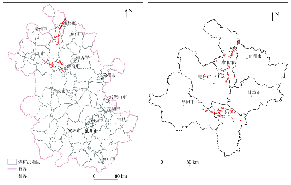
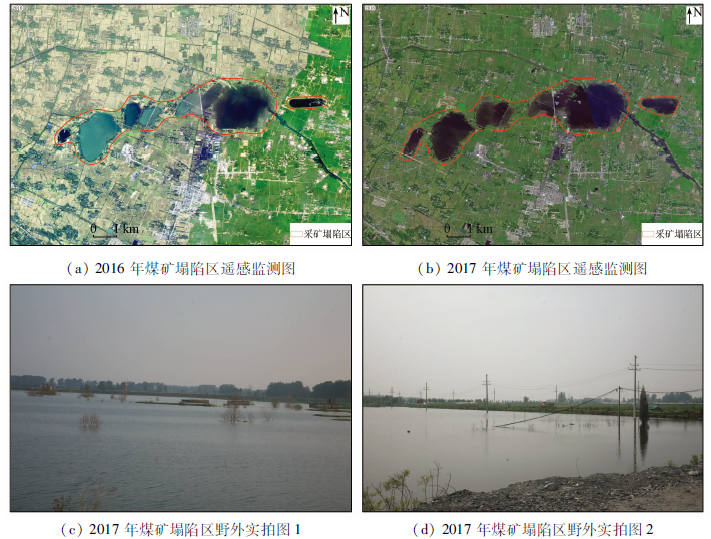
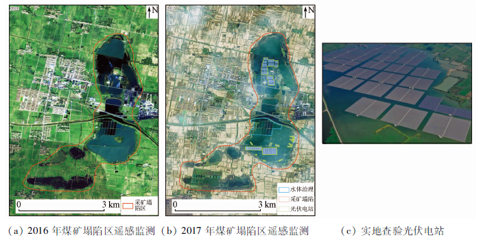
Abstract With the large-scale exploitation and utilization of coal resources, the geological environmental problems of coal mines have been increasingly severe, thus restricting social and economic development. This study aims to ascertain the disaster status of the collapse of the mined-out areas in Anhui Province, analyze the changing trend of the collapse areas, and summarize the countermeasures and methods for the collapse areas. With 2016—2017 remote sensing images of Anhui Province obtained from domestic GF satellites as an information source, this study conducted the processing, interpretation, and analysis of the remote sensing images and field surveys using the 3S technology (the collective term of remote sensing, global position system, and geographical information system). The results are as follows: ① The total area of the collapse areas in 2017 was 396.62 km2, accounting for 0.28% of the land area of the province; ② The growth rate of the area and quantity of collapse areas decreased compared with those in previous years; ③ A set of countermeasures and four treatment methods were proposed. As revealed by the results, the 3S technology-based remote sensing monitoring of the mine environment in Anhui Province can be used to produce high-quality data and extract relevant data information macroscopically, efficiently, and accurately, thus greatly improving the treatment efficiency of mine geological disasters. This study will provide technical support for the restoration, treatment, and sustainable development of the collapse areas of coal mines in the future.
|
| Keywords
remote sensing
coal mine
mined-out subsidence area
|
|
Issue Date: 20 March 2023
|
|
|
| [1] |
类磊. 煤矿采空区沉陷引发的地质灾害综合治理——以孝义采煤沉陷区为例[J]. 华北自然资源, 2020(4):80-81.
|
| [1] |
Lei L. Comprehensive treatment of geological disasters caused by subsidence of goaf in coal mine:Taking Xiaoyi coal mining subsidence area as an example[J]. Huabei Natural Resources, 2020(4):80-81.
|
| [2] |
马艳有. 煤矿采空区塌陷地系统分类与开发利用模式匹配[D]. 保定: 河北农业大学, 2020.
|
| [2] |
Ma Y Y. Systematic classification and development and utilization pattern matching of subsidence land in coal mine goaf[D]. Baoding: Hebei Agricultural University, 2020.
|
| [3] |
毕卫华, 钱倬珺, 王辉, 等. 基于RSEI的采煤塌陷积水对生态环境的影响研究[J]. 中国矿业, 2021(12):38-44.
|
| [3] |
Bi W H, Qian Z J, Wang H, et al. Study on the impact of coal mining subsidence ponding on ecological environment based on RSEI[J]. China Mining Magazine, 2021, 30(12):38-44.
|
| [4] |
朱兴沛, 张亮, 朱乾坤, 等. 采煤塌陷新生湿地生态保护与修复措施研究——以沛县安国湖国家湿地公园为例[J]. 通化师范学院学报, 2022(4):6-14.
|
| [4] |
Zhu X P, Zhang L, Zhu Q K, et al. Study on ecological protection and restoration measures of coal mining subsidence nascent wetland-Taking Anguo Lake national wetland park in Peixian County as an example[J]. Journal of Tonghua Normal University, 2020(4):6-14.
|
| [5] |
海如拉·热合曼. 煤矿采空区地表塌陷的预测分析[J]. 华北自然资源, 2021(4):112-113.
|
| [5] |
Hairula R H M. Prediction and analysis of surface collapse in goaf[J]. Huabei Natural Resources, 2021(4):112-113.
|
| [6] |
田雅璠. 煤矿塌陷区对生态环境的影响及综合治理措施[J]. 建设标准化, 2021(10):20-22.
|
| [6] |
Tian Y F. Influence of coal mine subsidence area on ecological environment and comprehensive control measures[J]. Construction Standardization, 2021(10):20-22.
|
| [7] |
刘朝华. 治理煤矿塌陷区,发展生态农业[J]. 农业开发与装备, 2021(9):32-33.
|
| [7] |
Liu C H. Harnessing coal mine subsidence areas and developing ecological agriculture[J]. Agricultural Development and Equipment, 2021(9):32-33.
|
| [8] |
Nishant K, Lal C,R.E. Reclamation of overburden and lowland in coal mining area with fly ash and selective plantation:A sustainable ecological approach[J]. Ecological Engineering, 2014(71): 479-489.
|
| [9] |
Jay S, Gregory S A. Optimal hardwood tree planting and forest reclamation policy on reclaimed surface mine lands in the appalachian coal region[J]. Resources Policy, 2013(38): 1-7.
|
| [10] |
诸葛雷, 王其雷, 宋宗超. 山东省采煤塌陷地综合治理模式研究[J]. 山东煤炭科技, 2015(4):166-167,169.
|
| [10] |
Zhu G L, Wang Q L, Song Z C. Study on comprehensive control mode of coal mining subsidence in Shandong Province[J]. Shandong Coal Technology, 2015(4):166-167,169.
|
| [11] |
张磊. 安徽:煤炭资源优势转化为经济优势.[EB/OL](2013-10-08) https://www.china5e.com/news/news-847945-1.html.
url: https://www.china5e.com/news/news-847945-1.html
|
| [11] |
Zhang L. AnHui:Transformation of coal resource advantages into economic advantages. [EB/OL](2013-10-08) https://www.china5e.com/news/news-847945-1.html.
url: https://www.china5e.com/news/news-847945-1.html
|
| [12] |
朱省峰. 安徽省淮北市煤矿采空塌陷现状与治理对策分析[J]. 安徽地质, 2009, 3(1):74-77.
|
| [12] |
ZHU X F. Current situation and treatment measure analysis of mining collapses in coal mines in Huaibei City,Anhui Province[J]. Anhui Geology, 2009, 3(1):74-77.
|
| [13] |
边海清. 煤矿区地质灾害风险评价及防治对策研究——以榆神矿区为例[D]. 西安: 西安科技大学, 2017.
|
| [13] |
Bian H Q. Study on risk assessment and control measures of geological hazards-A case study taking Yushen mining area[D]. Xi’an: Xi’an University of Science and Technology, 2017.
|
| [14] |
杨显华, 黄洁, 田里, 等. 矿山遥感监测在采空区稳定性分析中的应用[J]. 国土资源遥感, 2018, 30(3):143-150.doi:10.6046/gtzyyg.2018.03.20.
doi: 10.6046/gtzyyg.2018.03.20
|
| [14] |
Yang X H, Huang J, Tian L, et al. Application of mine remote sensing monitoring to analysis of mine goaf stability[J]. Remote Sensing for Land and Resources, 2018, 30(3) : 143-150.doi:10.6046/gtzyyg.2018.03.20.
doi: 10.6046/gtzyyg.2018.03.20
|
| [15] |
尹伶俐, 张芹芹. 煤矿塌陷区的治理对策分析[J]. 绿色科技, 2011(1):93-94.
|
| [15] |
Yin L L, Zhang Q Q. Analysis of countermeasures of coal mine collapse areas[J]. Journal of Green Science and Technology, 2011(1):93-94.
|
| [16] |
张复明. 矿产开发负效应与资源生态环境补偿机制研究[J]. 中国工业经济, 2009(12):5-15.
|
| [16] |
Zhang F M. Study on the negative effects of mineral exploitation and the compensation mechanism of resources and ecological environment[J]. China’s Industrial Economy, 2009(12):5-15.
|
| [17] |
宋晓慧. 采煤塌陷区综合治理模式研究—以菏泽市为例[D]. 济南: 山东财经大学, 2017.
|
| [17] |
Song X H. The research on comprehensive management mode of coal mining subsidence area:A case study of Heze City[D]. Jinan: Shandong University of Finance and Economics, 2017.
|
| [18] |
祝国军. 淮北平原煤矿塌陷区的综合开发[J]. 国土与自然资源研究, 1993, 2(2):10-13.
|
| [18] |
Zhu G J. Comprehensive development of coal mine subsidence area in Huaibei plain[J]. Land and Natural Resources Research, 1993, 2(2):10-13.
|
| [19] |
王志强. 煤矿采空塌陷易发性分析及其防范——以广德县长广煤矿为例[J]. 西部探矿工程, 2020(9),4-6.
|
| [19] |
Wang Z Q. Analysis and prevention of coal mine goaf collapse——Take the Changguang coal mine in Guangde County[J]. Western Prospecting Project, 2020(9),4-6.
|
| [20] |
王海庆, 杨金中, 陈玲, 等. 采煤沉陷区恢复治理状况遥感调查[J]. 国土资源遥感, 2017, 29(3):156-162.doi:10.6046/gtzyyg.2017.03.23.
doi: 10.6046/gtzyyg.2017.03.23
|
| [20] |
Wang H Q, Yang J Z, Chen L, et al. Remote sensing investigation of restoration and management situation in coal mine subsidence areas[J]. Remote Sensing for Land and Resources, 2017, 29(3):156-162.doi:10.6046/gtzyyg.2017.03.23.
doi: 10.6046/gtzyyg.2017.03.23
|
|
Viewed |
|
|
|
Full text
|
|
|
|
|
Abstract
|
|
|
|
|
Cited |
|
|
|
|
| |
Shared |
|
|
|
|
| |
Discussed |
|
|
|
|
 2023,
Vol. 35
2023,
Vol. 35