|
|
 |
|

|
|
|
Assessing intensive urban land use based on remote sensing images and industry survey data |
WANG Haiwen1,2,3( ), JIA Junqing2, LI Beichen2, DONG Yongping4, HA Sier4 ), JIA Junqing2, LI Beichen2, DONG Yongping4, HA Sier4 |
1. School of Geography Science, Inner Mongolia Normal University, Hohhot 010010, China
2. Inner Mongolia Land and Space Planning Institute, Hohhot 010010, China
3. Inner Mongolia Autonomous Region Land Use and Renovation Engineering Technology Research Center, Hohhot 010010, China
4. Xi’an Changlin Fengcao Ecological Technology Co., Ltd., Xi’an 710000, China |
|
|
|
|
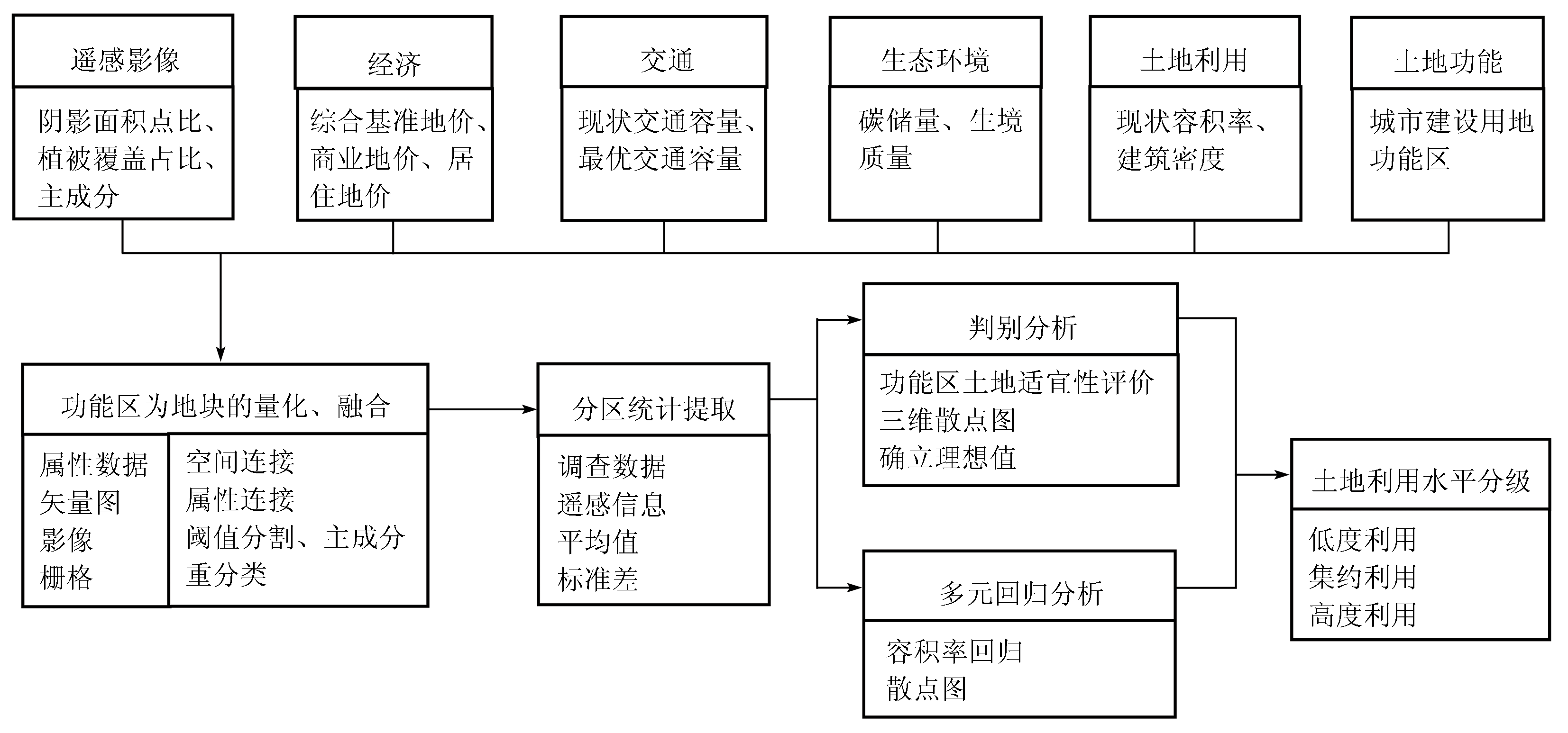
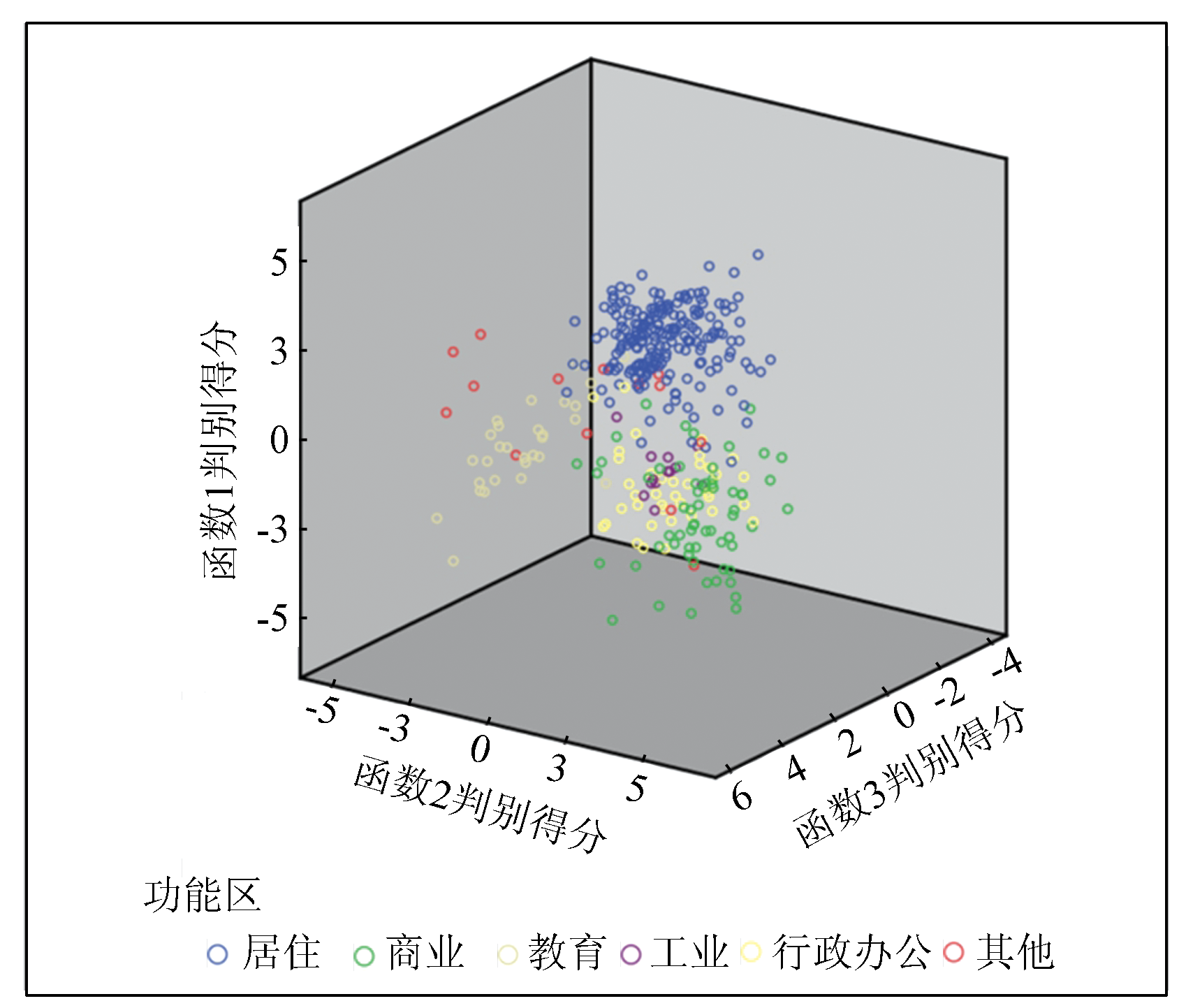
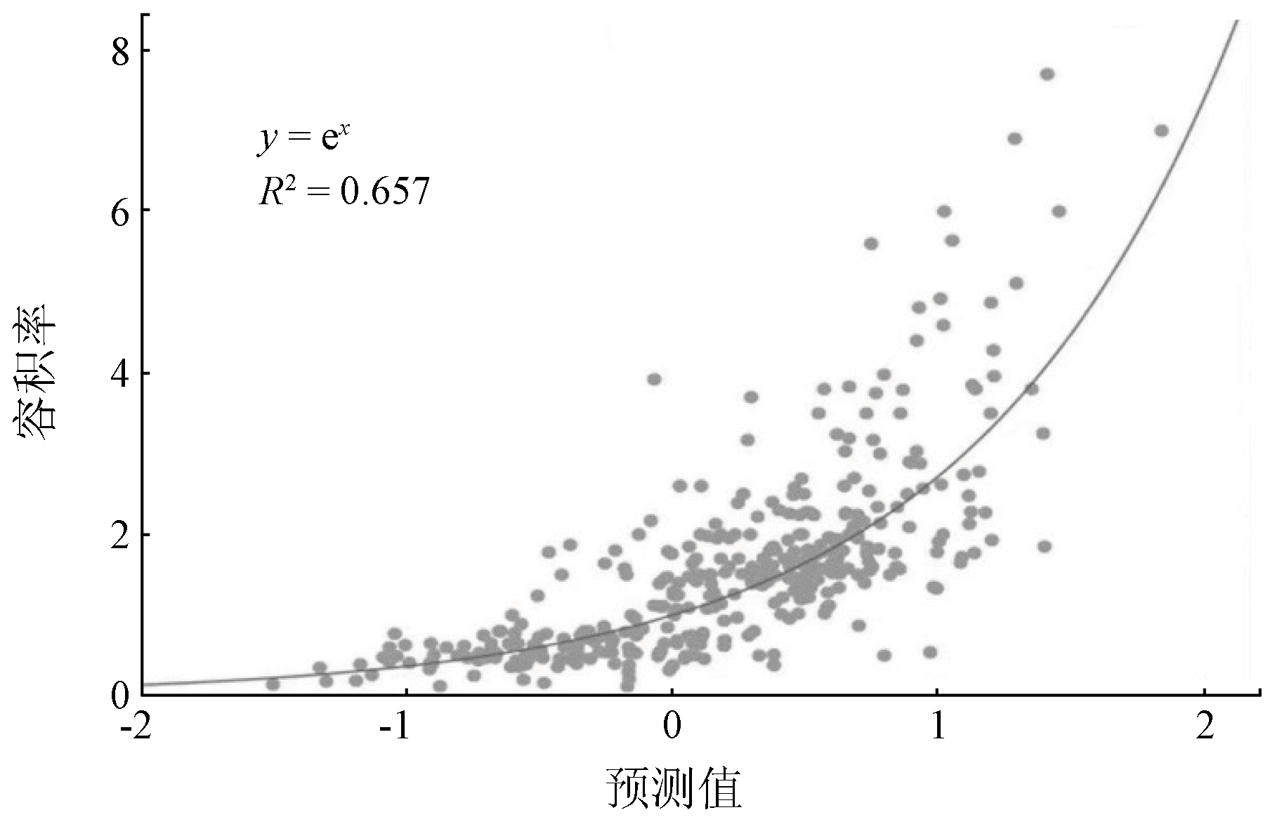
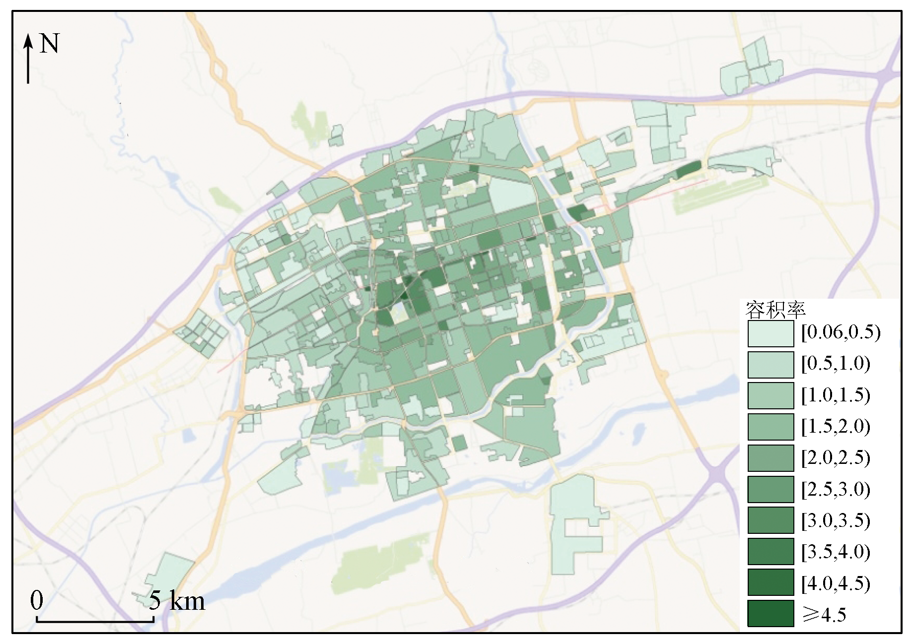
Abstract To scientifically evaluate the land suitability of urban functional areas and to accurately assess the intensive urban land use (IULU) in Hohhot City, this study built an indicator system by integrating the industry survey data and the features extracted from remote sensing images. Then, it assessed the urban function zoning and the IULU in Hohhot through quantification and integration based on land. The results show that 93.0% of the functional areas share common multivariate quantitative characteristics, indicating suitable functional orientation and land use. Moreover, this study built a high-precision multivariate regression model using remote sensing factors (i.e., the principal components of images and the proportions of the shadow and vegetation areas) and survey data (i.e., carbon stock, building density, and the land prices of residential and commercial functional areas). Then, the floor area ratio was calculated based on the model, thus achieving the quantitative assessment of the IULU. The results of this study show that the assessment of IULU based on remote sensing images and industry survey data is feasible and has value in popularization and applications.
|
| Keywords
land resources
intensive urban land use
remote sensing
floor area ratio
|
|
|
|
Issue Date: 07 July 2023
|
|
|
| [1] |
黄凌翔. 土地供给经济系统运行时空变化特征及政策绩效评价研究——基于宏观调控视角[J]. 当代经济管理, 2015, 37(4):74-78.
|
| [1] |
Huang L X. A study from the macroeconomic regulation perspective on the spatial-temporal change character of land supply economic system and the land policy performance evaluation[J]. Contemporary Economic Management, 2015, 37(4):74-78.
|
| [2] |
楚立. 基于两种方法下的城市土地集约利用评价研究[D]. 北京: 中国地质大学(北京), 2021.
|
| [2] |
Chu L. The evaluation of urban land intensive utilization based on two methods:Take Zhengzhou City as an example[D]. Beijing: China University of Geosciences (Beijing), 2021.
|
| [3] |
梁流涛, 樊鹏飞. 基于生态健康与低碳发展的城市土地集约利用评价及障碍因子诊断研究[C]// 中国土地学会.2015海峡两岸土地学术交流会, 2015,79-88.
|
| [3] |
Liang L T, Fan P F. Evaluation of urban land intensive use and diagnosis of obstacle factors based on ecological health and low-carbon development[C]// Chima Land Society.2015 Cross-Strait Land Academic Exchange Conference, 2015,79-88.
|
| [4] |
孙峰, 郑振兴. 兼顾总量平衡与刚柔适度的容积率控制方法[J]. 规划师, 2013, 29(6):47-51.
|
| [4] |
Sun F, Zheng Z X. Balanced FAR control in general amount and rigidity-flexibility[J]. Planner, 2013, 29(6):47-51.
|
| [5] |
路昊, 罗霞. TOD模式下轨道交通站点周边土地利用优化模型[J]. 综合运输, 2020, 42(1):38-43.
|
| [5] |
Lu H, Luo X. Optimization model of land use surrounding rail transit stations based on TOD[J]. China Transportation Review, 2020, 42(1):38-43.
|
| [6] |
闫晓丹, 乌兰高娃, 陈飞. “容积率”对城市土地利用的影响[J]. 内蒙古科技与经济, 2012(21):8-9.
|
| [6] |
Yan X D, Wu L G W, Chen F. The impact of “FAR” on urban land use[J]. Inner Mongolia Science Technology & Economy, 2012(21):8-9.
|
| [7] |
邓凌云, 尹长林. 科学发展观下容积率的合理制定[J]. 山西建筑, 2006, 32(20):53-55.
|
| [7] |
Deng L Y, Yin C L. Rational setting down floor area ratio under the guidance of scientific development view[J]. Shanxi Architecture, 2006, 32(20):53-55.
|
| [8] |
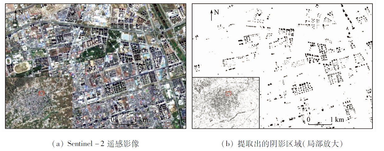
刘小洲, 周石琳, 李智勇. 高分辨率遥感图像中建筑物阴影的提取[J]. 计算机仿真, 2008, 25(8):197-200.
|
| [8] |
Liu X Z, Zhou S L, Li Z Y. Extraction of building shadows from urban high resolution remote sensing image[J]. Computer Simulation, 2008, 25(8):197-200.
|
| [9] |
刘恒慧, 曾忠平. 武汉东湖风景区对周边住宅价格影响的研究[J]. 资源开发与市场, 2013, 29(6):585-589.
|
| [9] |
Liiu H H, Zeng Z P. Impacts of east lake scenic area in Wuhan on values of adjoining residential property[J]. Resource Development & Market, 2013, 29(6):585-589.
|
| [10] |
秦涛. 基于空间句法的徐州市道路结构与地价关系分析[J]. 首都师范大学学报(自然科学版), 2010, 31(1):55 -59.
|
| [10] |
Qin T. The relation of the city traffic network and the land prices based on the space syntax:For Xuzhou[J]. Journal of Capital Normal University (Natural Science Edition), 2010, 31(1):55 -59.
|
| [11] |
刘恒慧. 基于HPM和GIS的武汉市湖泊景观对周边住宅价格影响的研究[D]. 武汉: 华中科技大学, 2013.
|
| [11] |
Liu H H. Research on the influence of lake landscape in Wuhan to the values of adjoining residential property based on HPM and GIS[D]. Wuhan: Huazhong University of Science & Technology, 2013.
|
| [12] |
尹君, 谢俊奇, 王力, 等. 基于RS的城市土地集约利用评价方法研究[J]. 自然资源学报, 2007, 22(5):775-782.
|
| [12] |
Yin J, Xie J Q, Wang L, et al. The evaluation of urban land intensive use based on RS[J]. Journal of Natural Resources, 2007, 22(5):775-782.
doi: 10.11849/zrzyxb.2007.05.012
|
| [13] |
王力, 牛铮, 尹君, 等. 基于RS和ANN的城市土地集约利用潜力评价[J]. 重庆建筑大学学报, 2007, 29(3):32-35.
|
| [13] |
Wang L, Niu Z, Yin J, et al. Potential evaluation of land intensive use in metropolis based on RS and ANN[J]. Journal of Chongqing Jianzhu University, 2007, 29(3):32-35.
|
| [14] |
李向朋. 缓解城市交通拥堵对策——封闭型小区交通开放研究[D]. 长沙: 长沙理工大学, 2014.
|
| [14] |
Li X P. Urban traffic congestion countermeasures:Opening research of enclosed type district traffic[D]. Changsha: Changsha University of Science & Technology, 2014.
|
| [15] |
吴瑞艳. 内蒙古中西部能源开发典型区——东胜区土地生态安全评价[D]. 内蒙古师范大学, 2018.
|
| [15] |
Wu R Y. Study on land ecological security evaluation in DongSheng district:The typical area of energy development in central and western region of Inner Mongolia[D]. Hohhot: Inner Mongolia Normal University, 2018.
|
| [16] |
庄大方, 刘纪远. 中国土地利用程度的区域分异模型研究[J]. 自然资源学报, 1997, 12(2):105-111.
|
| [16] |
Zhuang D F, Liu J Y. Study on the model of regional differentiation of land use degree in China[J]. Journal of Natural Resources, 1997, 12(2):105-111.
|
| [17] |
Robyn L, Kelli O’Neill. Nature’s services:Societal dependence on natural ecosystems[J]. Pacific Conservation Biology, 2000, 6(3):274-274.
doi: 10.1071/PC000274
url: http://www.publish.csiro.au/?paper=PC000274
|
| [18] |
Robert C, Ralph d’Arge, Rudolf de Groot, et al. The value of the world’s ecosystem services and natural capital[M]. Nature, 1997, 387(6630):253-260.
|
| [19] |
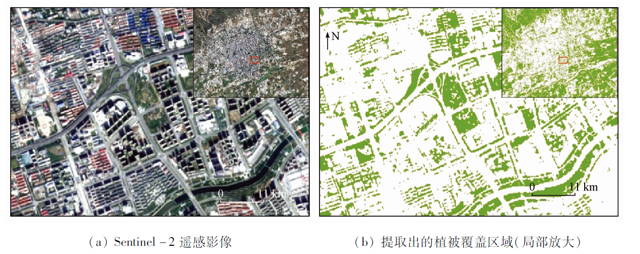
严红萍, 俞兵. 主成分分析在遥感图像处理中的应用[J]. 资源环境与工程, 2006, 20(2):168-170.
|
| [19] |
Yan H P, Yu B. The principal component analysis for RS image processing[J]. Resources Environment & Engineering, 2006, 20(2):168-170.
|
| [20] |
吴嵩, 姜琦刚. 基于RS和GIS的小城市建设用地集约利用状况评价[J]. 中国人口资源与环境, 2015, 25(s1):53-57.
|
| [20] |
Wu S, Jiang Q G. Evaluation of intensive land use in the small city based on RS and GIS[J]. China Population,Resources and Environment, 2015, 25(s1):53-57.
|
| [21] |
苑伟. 基于GIS的天津城镇土地级别调整与基准地价更新[J]. 山西建筑, 2013, 39(29):205-207.
|
| [21] |
Yuan W. On land level filtering and update of datum land price of towns in Tianjin based on GIS[J]. Shanxi Architecture, 2013, 39(29):205-207.
|
| [22] |
强真, 朱道林, 毕继业. 城市基准地价合理性判别方法研究[J]. 中国土地科学, 2005, 19(1):56-61.
|
| [22] |
Qiang Z, Zhu D L, Bi J Y. Study on methods of judging the rationality of base land price[J]. China Land Science, 2005, 19(1):56-61.
|
| [23] |
安艺明, 赵文武, 姜广辉, 等. 基于MapGIS地价系统的城镇土地定级研究——以德州市城区商服用地定级为例[J]. 中国农学通报, 2013,(23):51-58.
|
| [23] |
An Y M, Zhao W W, Jiang G H, et al. Study on urban land grading based on the MAPGIS land price system:Taking the commercial land in Dezhou City for example[J]. Chinese Agricultural Science Bulletin, 2013(23):51-58.
|
| [24] |
聂艳, 周勇, 于婧, 等. 基于GIS和模糊物元分析法的农用地定级评价研究[J]. 农业工程学报, 2004, 20(5):297-300.
|
| [24] |
Nin Y, Zhou Y, Yu J, et al. Gradation of agricultural land based on GIS and the fuzzy-material analysis method[J]. Transactions of the Chinese Society of Agricultural Engineering, 2004, 20(5):297-300.
|
| [25] |
李龙华. 基于GIS的石泉县城镇土地基准地价评估研究[D]. 西安: 长安大学, 2015.
|
| [25] |
Li L H. Study on the assessment of Shiquan County town benchmark land price based on GIS[D]. Xi’an: Chang’an University, 2015.
|
| [26] |
盛艳蕊. 基于GIS的城镇土地定级和标定地价的研究[D]. 合肥: 合肥工业大学, 2007.
|
| [26] |
Sheng Y R. Study of urban land grading and demarcated land price based on GIS[D]. Hefei: Hefei University of Technology, 2007.
|
| [27] |
高璐. 基于GIS的城镇土地定级与基准地价更新研究——以淄博市周村区为例[D]. 泰安: 山东农业大学, 2013.
|
| [27] |
Gao L. Studies on the grade of cities land and the update of the datum land prices based on the GIS:A case of Zhoucun, Zibo City[D]. Taian: Shandong Agricultural University, 2013.
|
| [28] |
孙一鸣, 张宝钢, 吴其重, 等. 国产维景一号小卫星影像的城市裸地识别应用[J]. 自然资源遥感, 2022, 34(1):189-197.doi:10.6046/zrzyyg.2021056.
doi: 10.6046/zrzyyg.2021056
|
| [28] |
Sun Y M, Zhang B G, Wu Q Z, et al. Application of domestic low-cost micro-satellite images in urban bare land identification[J]. Remote Sensing for Natural Resources, 2022, 34(1):189-197.doi:10.6046/zrzyyg.2021056.
doi: 10.6046/zrzyyg.2021056
|
| [29] |
吴琳琳, 李晓燕, 毛德华, 等. 基于遥感和多源地理数据的城市土地利用分类[J]. 自然资源遥感, 2022, 34(1):127-134.doi:10.6046/zrzyyg.2021061.
doi: 10.6046/zrzyyg.2021061
|
| [29] |
Wu L L, Li X Y, Mao D H, et al. Urban land use classification based on remote sensing and multi-source geographic data[J]. Remote Sensing for Natural Resources, 2022, 34(1):127-134.doi:10.6046/zrzyyg.2021061.
doi: 10.6046/zrzyyg.2021061
|
|
Viewed |
|
|
|
Full text
|
|
|
|
|
Abstract
|
|
|
|
|
Cited |
|
|
|
|
| |
Shared |
|
|
|
|
| |
Discussed |
|
|
|
|
 2023,
Vol. 35
2023,
Vol. 35