|
|
 |
|

|
|
|
A quality-guided least squares phase unwrapping algorithm |
XIAO Hui1,2( ), LI Huitang1(), GU Yuehan1, SHENG Qinghong1 ), LI Huitang1(), GU Yuehan1, SHENG Qinghong1 |
1. College of Astronautics, Nanjing University of Aeronautics and Astronautics, Nanjing 210016, China
2. School of Environmental Sciences, Nanjing Xiaozhuang University, Nanjing 211171, China |
|
|
|
|
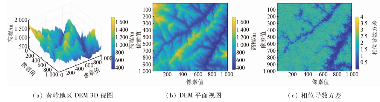
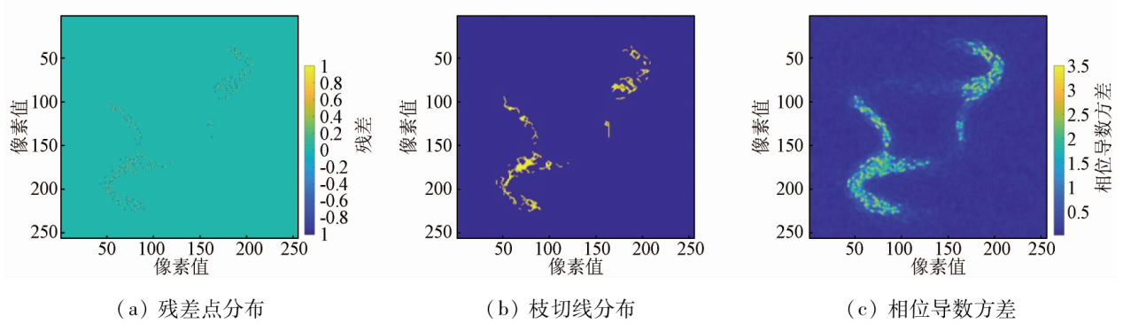
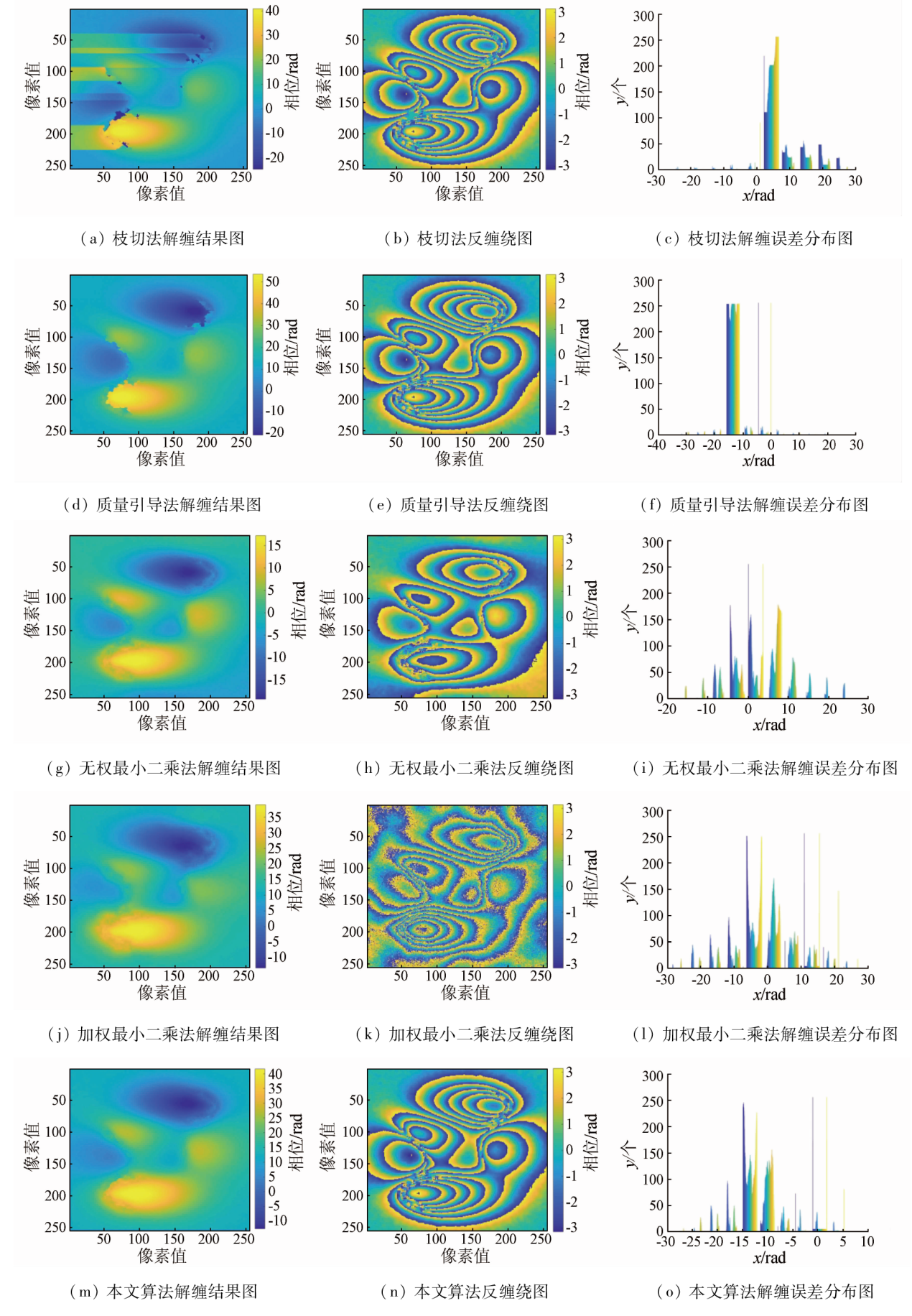
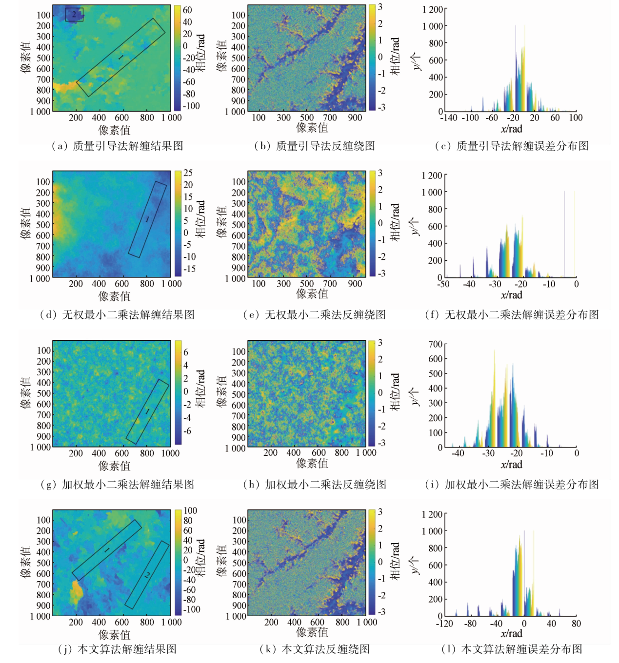
Abstract Interferometric synthetic aperture Radar (InSAR) can extract three-dimensional information about a ground target from the phase information in an interferogram. Phase unwrapping is an important step in the InSAR process, and its accuracy dictates the accuracy of the digital elevation model (DEM) or the ground deformation information. To overcome the serious phase decorrelation and phase noise in complex mountainous areas, this study divided the study area according to the quality of interference phases and proposed a quality-guided least squares phase unwrapping algorithm. Then, the algorithm was employed for the phase unwrapping of simulated low-noise interferometric phase data and Sentinel-1A InSAR interferometric images of the Qinling area of China. The results show that the proposed algorithm can effectively improve the phase consistency among high- and low-quality zones and the overall accuracy of phase unwrapping.
|
| Keywords
InSAR
phase unwrapping
quality-guided method
least squares method
|
|
|
|
Issue Date: 21 December 2023
|
|
|
| [1] |
周伟文. 利用星载InSAR 技术获取DEM及误差来源分析[J]. 测绘与地理信息, 2019, 42(2):135-137.
|
| [1] |
Zhou W W. Analysis of DEM and error sources using spaceborne InSAR technique[J]. Geomatics and Spatial Information Technology, 2019, 42(2):135-137.
|
| [2] |
Rosen P A, Hensley S, Joughin I R, et al. Synthetic aperture Radar interferometry[J]. Proceedings of the IEEE, 2000, 88(3):333-382.
doi: 10.1109/5.838084
url: http://ieeexplore.ieee.org/document/838084/
|
| [3] |
Gao Y, Zhang S, Li T, et al. Adaptive unscented Kalman filter phase unwrapping method and its application on Gaofen-3 interferometric SAR data[J]. Sensors, 2018, 18(6):1793.
doi: 10.3390/s18061793
url: http://www.mdpi.com/1424-8220/18/6/1793
|
| [4] |
余博, 李如仁, 陈振炜, 等. “高分三号”卫星图像干涉测量试验[J]. 航天返回与遥感, 2019, 40(1):66-73.
|
| [4] |
Yu B, Li R R, Chen Z W, et al. Image interferometry experiment of GF-3 satellite[J]. Spacecraft Recovery and Remote Sensing, 2019, 40(1): 66-73.
|
| [5] |
Sheng Q H, Li H T, Guo Y H, et al. Minimum cost flow phase unwrapping method considering range direction slope[J]. Journal of Applied Remote Sensing, 2022, 16(1): 014517.
|
| [6] |
刘国祥, 陈强, 罗小军. InSAR原理与应用[M]. 北京: 科学出版社, 2019.
|
| [6] |
Liu G X, Chen Q, Luo X J. Principle and application of InSAR[M]. Beijing: Science Press, 2019.
|
| [7] |
Gabriel A K, Goldstein R M, Zebker H A. Mapping small elevation changes over large areas:Differential Radar interferometry[J]. Journal of Geophysical Research Solid Earth:Solid Earth, 1989, 94(b7): 9183-9191.
|
| [8] |
Bone D J. Fourier fringe analysis:The two-dimensional phase unwrapping problem[J]. Applied Optics, 1991, 30(25):3627-3632.
doi: 10.1364/AO.30.003627
pmid: 20706437
|
| [9] |
岑小林, 毛建旭. 质量图和残差点相结合的InSAR相位解缠方法[J]. 遥感技术与应用, 2008, 23(5):556-560.
|
| [9] |
Cen X L, Mao J X. InSAR phase unwrapping method using quality map with residues[J]. Remote Sensing Technology and Application, 2008, 23(5):556-560.
|
| [10] |
赵振强. 基于深度学习的InSAR相位解缠算法研究[D]. 北京: 中国地质大学(北京), 2019.
|
| [10] |
Zhao Z Q. Research on InSAR phase unwrapping algorithm based on deep learning[D]. Beijing: China University of Geoscience(Beijing), 2019.
|
| [11] |
Ghiglia D C, Romero L A. Minimum Lp-norm two-dimensional phase unwrapping[J]. Journal of the Optical Society of America A, 1996, 13(10):1999-2013.
doi: 10.1364/JOSAA.13.001999
url: https://opg.optica.org/abstract.cfm?URI=josaa-13-10-1999
|
| [12] |
Lei Y, Qian F, Gang W Z. Optimized minimum spanning tree phase unwrapping algorithm for phase image of interferometric SAR[C]// 2006 6th International Conference on ITS Telecommunications.IEEE, 2006:1240-1243.
|
| [13] |
钱晓凡, 王占亮, 胡特, 等. 用单幅数字全息和剪切干涉原理重构光场相位[J]. 中国激光, 2010, 37(7):1821-1826.
|
| [13] |
Qian X F, Wang Z L, Hu T, et al. Reconstructing the phase of wavefront using digital hologram and the principle of shearing interferometry[J]. Chinese Journal of Lasers, 2010, 37(7):1821-1826.
doi: 10.3788/CJL
url: http://www.opticsjournal.net/zgjg.htm
|
| [14] |
Costantini M. A novel phase unwrapping method based on network programming[J]. IEEE Transactions on Geoscience and Remote Sensing, 1998, 36(3):813-821.
doi: 10.1109/36.673674
url: http://ieeexplore.ieee.org/document/673674/
|
| [15] |
Carballo G F, Fieguth P W. Probabilistic cost functions for network flow phase unwrapping[J]. IEEE Transactions on Geoscience and Remote Sensing, 2000, 38(5):2192-2201.
doi: 10.1109/36.868877
url: http://ieeexplore.ieee.org/document/868877/
|
| [16] |
于勇, 王超, 张红, 等. 基于不规则网络下网络流算法的相位解缠方法[J]. 遥感学报, 2003, 7(6):472-477.
|
| [16] |
Yu Y, Wang C, Zhang H, et al. A phase unwrapping method based on network flow algorithm in irregular network[J]. Journal of Remote Sensing, 2003, 7(6):472-477.
|
| [17] |
李伟华, 张华春, 张衡. 基于StereoSAR辅助的InSAR DEM重建方法研究[J]. 现代雷达, 2020, 42(1):55-63.
|
| [17] |
Li W H, Zhang H C, Zhang H. InSAR DEM reconstruction method based on StereoSAR[J]. Modern Radar, 2020, 42(1):55-63.
|
| [18] |
高延东. 面向高精度DEM的InSAR关键处理技术研究[D]. 徐州: 中国矿业大学, 2019.
|
| [18] |
Gao Y D. Research on key processing technology of InSAR for high precision DEM[D]. Xuzhou: China University of Mining and Technology, 2019.
|
|
Viewed |
|
|
|
Full text
|
|
|
|
|
Abstract
|
|
|
|
|
Cited |
|
|
|
|
| |
Shared |
|
|
|
|
| |
Discussed |
|
|
|
|
 2023,
Vol. 35
2023,
Vol. 35