|
|
|
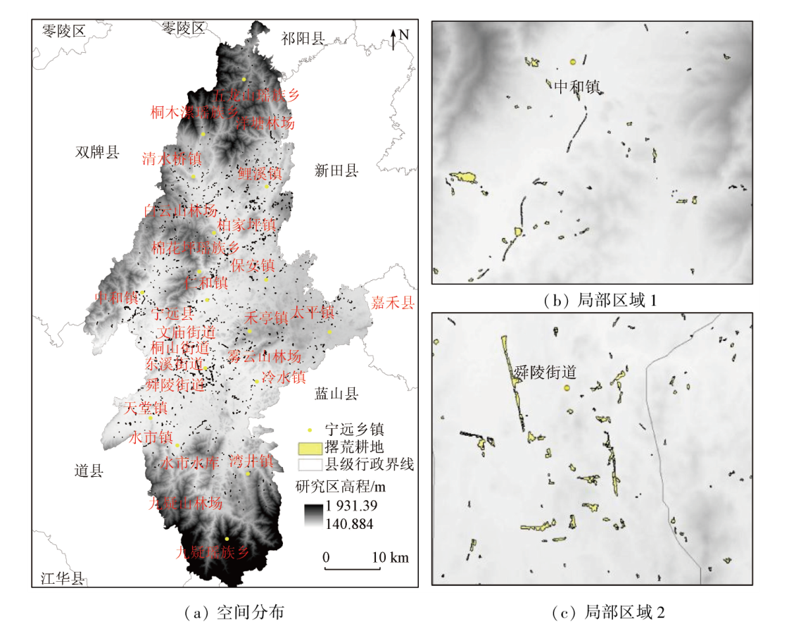
Abstract With continuously accelerated urbanization, urban expansion-induced farmland occupation and rural hollowing have gradually aggravated arable land abandonment, posing challenges to China’s food security. Hence, accurately determining the distribution of abandoned arable land is critical to arable land protection and food security. This study investigated a county in the major crop production area in a hilly region in southern China. Based on the phenological characteristics of local rice planting, this study adopted six phases of satellite remote sensing images and aerial images acquired in 2020 and 2021 were used as the data source and selected paddy fields determined based on the Third National Land Survey and field ridges in 1∶2 000 digital line graphics (DLGs) as the minimum information extraction unit. Then, the rice planting patches were extracted through time-series normalized difference vegetation index (NDVI) analysis and the improved SVM method. Suspected abandoned areas were screened out through the difference calculation for two consecutive years and then further identified in the unmanned aerial vehicle (UAV)-based sampling aerial survey. Consequently, the abandoned arable land areas were determined, with monitoring accuracy exceeding 85%, as revealed by on-site verification. The results of this study show that the space-air-ground integrated remote sensing monitoring method can provide scientific and effective data support for agricultural management departments to control and manage cultivated land abandonment.
|
| Keywords
satellite remote sensing
arable land abandonment
arable land protection
remote sensing monitoring
|
|
|
|
Issue Date: 13 March 2024
|
|
|
| [1] |
王新友, 王玉娇. 耕地撂荒的文献计量分析:脉络和展望[J]. 干旱区地理, 2023, 46(5):804-813.
|
| [1] |
Wang X Y, Wang Y J. Bibliometric analysis of cultivated land abandonment:Context and prospect[J]. Arid Land Geography, 2023, 46(5):804-813.
|
| [2] |
李升发, 李秀彬. 耕地撂荒研究进展与展望[J]. 地理学报, 2016, 71(3):370-389.
doi: 10.11821/dlxb201603002
|
| [2] |
Li S F, Li X B. Progress and prospect on farmland abandonment[J]. Acta Geographica Sinica, 2016, 71(3):370-389.
doi: 10.11821/dlxb201603002
|
| [3] |
马清欣, 何三林. 对当前农村耕地撂荒和耕地质量下降问题的探讨[J]. 中国农业资源与区划, 2002, 23(4):19-21.
|
| [3] |
Ma Q X, He S L. To probe into the problems of arable land wasting and its quality declining in rural areas at present[J]. Journal of China Agricultural Resources and Regional Planning, 2002, 23(4):19-21.
|
| [4] |
Estel S, Kuemerle T, Alcántara C, et al. Mapping farmland abandonment and recultivation across Europe using MODIS NDVI time series[J]. Remote Sensing of Environment, 2015, 163:312-325.
doi: 10.1016/j.rse.2015.03.028
url: https://linkinghub.elsevier.com/retrieve/pii/S003442571500125X
|
| [5] |
Xu Z, Mi W B, Mi N, et al. Characteristics and sources of heavy metal pollution in desert steppe soil related to transportation and industrial activities.[J]. Environmental Science and Pollution Research, 2020, 27(31):38835-38848.
doi: 10.1007/s11356-020-09877-9
|
| [6] |
Sayfullina L B, Azizov Z M, Imashev I G, et al. Soil nitrification capacity as an integral indicator of soil fertility monitoring[J]. Russian Agricultural Sciences, 2022, 48(4) :290-295.
doi: 10.3103/S1068367422040127
|
| [7] |
张昊, 高小红, 史飞飞, 等. 基于Sentinel-2 MSI与Sentinel-1 SAR相结合的黄土高原西部撂荒地提取——以青海民和县为例[J]. 自然资源遥感, 2022, 34(4):144-154.doi:10.6046/gtzyyg.2021385.
|
| [7] |
Zhang H, Gao X H, Shi F F, et al. based on the combination of Sentinel-2 MSI and Sentinel-1 SAR based extraction of abandoned land in the western the Loess Plateau:A case study of Minhe County in Qinghai[J]. Remote Sensing for Natural Resources, 2022, 34(4):144-154.doi:10.6046/gtzyyg.2021385.
|
| [8] |
王玲玉, 陈全, 吴跃, 等. 基于地块级时序NDVI的喀斯特山区撂荒地特征精准识别[J]. 国土资源遥感, 2020, 32(3):23-31.doi:10.6046/gtzyyg.2020.03.04.
|
| [8] |
Wang L Y, Chen Q, Wu Y, et al. Accurate recognition and extraction of karst abandoned land features based on cultivated land parcels and time series NDVI[J]. Remote Sensing for Land and Resources, 2020, 32 (3):23-31.doi:10.6046/gtzyyg.2020.03.04.
|
| [9] |
丁书培, 李蒙蒙, 汪小钦, 等. 基于时序遥感数据的福州市耕地非农化特征及驱动因子分析[J]. 遥感技术与应用, 2022, 37(3):550-563.
|
| [9] |
Ding S P, Li M M, Wang X Q, et al. The use of time series remote sensing data to analyze the characteristics of non-agriculture farmland and their driving factors in Fuzhou[J]. Remote Sensing Technology and Application, 2022, 37 (3):550-563.
|
| [10] |
牟昱璇, 邬明权, 牛铮, 等. 南方地区复杂条件下的耕地面积遥感提取方法[J]. 遥感技术与应用, 2020, 35(5):1127-1135.
|
| [10] |
Mu Y X, Wu M Q, Niu Z, et al. Method of remote sensing extraction of cultivated land area under complex conditions in southern region[J]. Remote Sensing Technology and Application, 2020, 35 (5):1127-1135.
|
| [11] |
张天柱, 张凤荣, 黄敬文, 等. 工业化区域撂荒耕地空间格局演变及影响因素分析[J]. 农业工程学报, 2019, 35(15):246-255.
|
| [11] |
Zhang T Z, Zhang F R, Huang J W, et al. Spatial pattern evolution of abandoned arable land and its influencing factor in industrialized region[J]. Transactions of the Chinese Society of Agricultural Engineering, 2019, 35 (15):246-255.
|
| [12] |
滕晓波, 欧阳文一, 雷博. 农民占耕地建房的成因及对策分析——以宁远县柏家坪镇四元山村为例[J]. 国土资源导刊, 2022, 19(1):72-75.
|
| [12] |
Teng X B, Ouyang W Y, Lei B. Analysis on causes and countermeasures of farmers occupying cultivated land to build houses:Taking Siyuanshan Village,Baijiaping Town,Ningyuan County as an example[J]. Land and Resources Herald, 2022, 19 (1):72-75.
|
| [13] |
蔡琼, 朱红梅, 肖婷. 耕地质量与耕地产能耦合度研究—以湖南宁远县为例[J]. 上海国土资源, 2022, 43(2):66-72.
|
| [13] |
Cai Q, Zhu H M, Xiao T. On coupling degree of cultivated land quality and productivity:A case study of Ningyuan County,Hunan Province as an example[J]. Shanghai Land and Resources, 2022, 43(2):66-72.
|
| [14] |
李升发, 李秀彬, 辛良杰, 等. 中国山区耕地撂荒程度及空间分布——基于全国山区抽样调查结果[J]. 资源科学, 2017, 39(10):1801-1811.
doi: 10.18402/resci.2017.10.01
|
| [14] |
Li S F, Li X B, Xin L J, et al. Extent and distribution of cropland abandonment in Chinese mountainous areas[J]. Resource Science, 2017, 39 (10):1801-1811.
|
| [15] |
牛继强, 林昊, 牛樱楠, 等. 经济欠发达地区撂荒耕地空间格局与驱动因素分析[J]. 农业机械学报, 2017, 48(2):141-149.
|
| [15] |
Niu J Q, Lin H, Niu Y N, et al. Analysis of spatial pattern and driving factors for abandoned arable lands in underdevelopment region[J]. Transactions of the Chinese Society for Agricultural Machinery, 2017, 48(2):141-149.
|
| [16] |
邓刚, 唐志光, 李朝奎, 等. 基于MODIS时序数据的湖南省水稻种植面积提取及时空变化分析[J]. 国土资源遥感, 2020, 32(2):177-185.doi:10.6046/gtzyyg.2020.02.23.
|
| [16] |
Deng G, Tang Z G, Li C K, et al. Extraction and analysis of spatiotemporal variation of rice planting area in Hunan Province based on MODIS time-series data[J]. Remote Sensing of Land and Resources, 2020, 32 (2):177-185.doi:10.6046/gtzyyg.2020.02.23.
|
| [17] |
柳文杰, 曾永年, 张猛. 融合时间序列环境卫星数据与物候特征的水稻种植区提取[J]. 遥感学报, 2018, 22(3):381-391.
|
| [17] |
Liu W J, Zeng Y N, Zhang M. Mapping rice paddy distribution by using time series HJ blend data and phenological parameters[J]. Journal of Remote Sensing, 2018, 22 (3):381-391.
|
| [18] |
马尚杰, 裴志远, 王飞, 等. 基于GF-1影像的沿淮地区冬季耕地撂荒遥感调查应用[J]. 农业工程学报, 2019, 35(1):227-233.
|
| [18] |
Ma S J, Pei Z Y, Wang F, et al. Application on remote sensing survey of abandoned farmlands in winter along the Huaihe River based on GF-1 image[J]. Transactions of the Chinese Society of Agricultural Engineering, 2019, 35(1):227-233.
|
| [19] |
肖国峰, 朱秀芳, 侯陈瑶, 等. 撂荒耕地的提取与分析——以山东省庆云县和无棣县为例[J]. 地理学报, 2018, 73(9):1658-1673.
doi: 10.11821/dlxb201809004
|
| [19] |
Xiao G F, Zhu X F, Hou C Y, et al. Extraction and analysis of abandoned farmland:A case study of Qingyun and Wudi Counties in Shandong Province as examples[J]. Acta Geographica Sinica, 2018, 73(9):1658-1673.
|
| [20] |
韦中晖, 靳海亮, 顾晓鹤, 等. 基于多时相协同变化检测的耕地撂荒遥感监测[J]. 遥感技术与应用, 2022, 37(3):539-549.
|
| [20] |
Wei Z H, Jin H L, Gu X H, et al. Remote sensing monitoring of cultivated land abandonment based on multi temporal collaborative change detection[J]. Remote Sensing Technology and Application, 2022, 37(3):539-549.
|
| [21] |
李赞红, 阎建忠, 花晓波, 等. 不同类型农户撂荒及其影响因素研究——以重庆市12个典型村为例[J]. 地理研究, 2014, 33(4):721-734.
doi: 10.11821/dlyj201404012
|
| [21] |
Li Z H, Yan J Z, Hua X B, et al. Factors influencing the culivated land abandonment of households of different types:A case study of 12 typical villages in Chongqing Municipality[J]. Geographical Research, 2014, 33 (4):721-734.
|
| [22] |
郑财贵, 邱道持, 叶公强, 等. 基于GIS空间分析的撂荒地空间分布特征研究——以重庆市璧山县大路镇为例[J]. 农机化研究, 2010, 32(3):31-36.
|
| [22] |
Zheng C G, Qiu D C, Ye G Q, et al. Study on spatial distribution characteristics of abandoned cropland based on spatial analysis of GIS:A case of Dalu Town Bishan County in Chongqing Municipality[J]. Journal of Agricultural Mechanization Research, 2010, 32(3):31-36.
|
|
Viewed |
|
|
|
Full text
|
|
|
|
|
Abstract
|
|
|
|
|
Cited |
|
|
|
|
| |
Shared |
|
|
|
|
| |
Discussed |
|
|
|
|
 2024,
Vol. 36
2024,
Vol. 36
 )
)