|
|
|
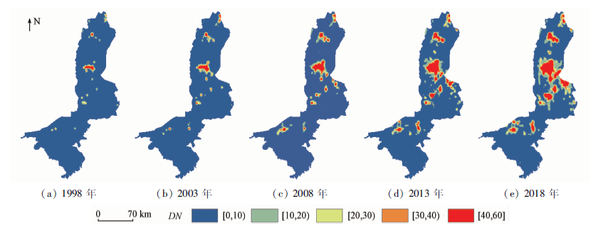
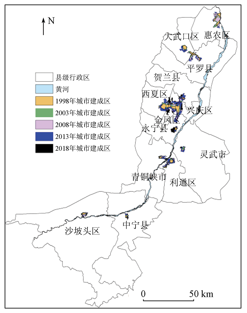
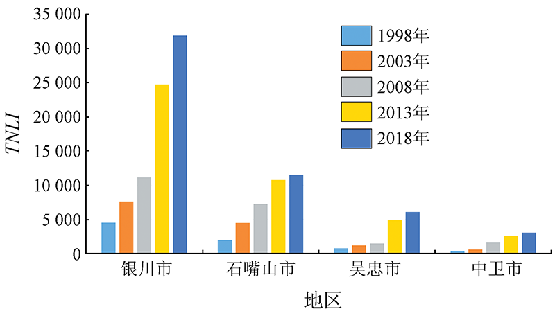
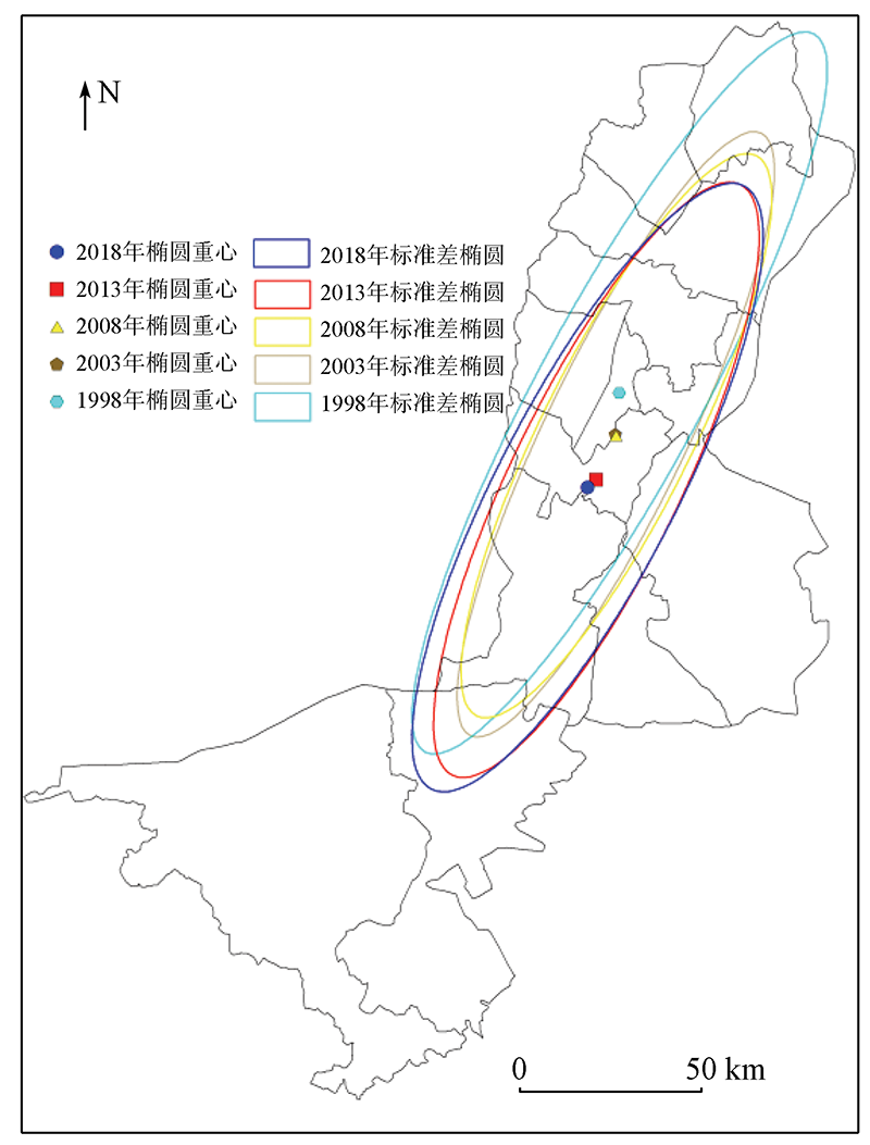
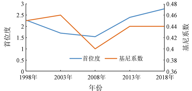
Abstract This study analyzed the spatio-temporal evolutionary characteristics of the Ningxia urban agglomeration along the Yellow River during 1998—2018 from the aspects of morphology, scale, and structure. To this end, the urban built-up area in the study area during the 20 years was extracted from five stages of DMSP/OLS and NPP/VIIRS nighttime light data using a high-resolution data comparison method. The results are as follows: ①The Ningxia urban agglomeration along the Yellow River expanded rapidly during 1998—2018, and the increment and growth rate peaked during 2008—2013. ②The constantly decreased fragmentation degree indicates that the inner morphology of the urban agglomeration became increasingly compact and the built-up patches were relatively concentrated. The fractal dimension continuously decreased, and the geometric shape of the urban agglomeration tended to be regular. Moreover, the urban agglomeration mainly expanded in the means of internal filling. ③The center of the urban agglomeration migrated to the southwest and approached its geometric center, and the urban development accelerated in the south. ④The primacy ratio and Gini coefficient of the urban agglomeration first decreased and then increased, indicating that the gap between cities in the urban agglomeration first narrowed and then widened.
|
| Keywords
Ningxia urban agglomeration along the Yellow River
nighttime light data
built-up area
spatio-temporal evolution
|
|
|
|
Corresponding Authors:
ZHANG Jiayu
E-mail: 13730100881@163.com;zhangjy@nxu.edu.cn
|
|
Issue Date: 14 March 2022
|
|
|
| [1] |
余柏蒗, 王丛笑, 宫文康, 等. 夜间灯光遥感与城市问题研究:数据、方法、应用和展望[J]. 遥感学报, 2021, 25(1):342-364.
|
| [1] |
Yu B L, Wang C X, Gong W K, et al. Nighttime light remote sensing and urban studies: Data,methods,applications,and prospects[J]. National Remote Sensing Bulletin, 2021, 25(1):342-364.
|
| [2] |
路春燕, 许燕婷, 林晓晴, 等. 基于DMSP/OLS夜间灯光数据的环渤海城市群时空演变研究[J]. 自然资源遥感, 2019, 31(4):218-226.doi: 10.6046/gtzyyg.2019.04.28.
doi: 10.6046/gtzyyg.2019.04.28
|
| [2] |
Lu C Y, Xu Y T, Lin X Q, et al. Study of spatio-temporal evolution of the circum-Bohai urban agglomeration based on DMSP/OLS nightime light data[J]. Remote Sensing for Land and Resources, 2019, 31(4):218-226.doi: 10.6046 /gtzyyg.2019.04.28.
doi: 10.6046 /gtzyyg.2019.04.28
|
| [3] |
李桂华, 范俊甫, 周玉科, 等. 基于VIIRS 夜间灯光数据的山东半岛城市群发展特征研究[J]. 遥感技术与应用, 2020, 35(6):1348-1359.
|
| [3] |
Li G H, Fan J F, et al.Zhou Y K. Development characteristics estimation of Shandong peninsula urban agglomeration using VIIRS night light data[J]. Remote Sensing Technology and Application, 2020, 35(6):1348-1359.
|
| [4] |
李德仁, 余涵若, 李熙. 基于夜光遥感影像的“一带一路”沿线国家城市发展时空格局分析[J]. 武汉大学学报(信息科学版), 2017, 42(6):711-720.
|
| [4] |
Li D R, Yu H R, Li X. The spatial-temporal pattern analysis of city development in countries along the Belt and Road Initiative based on nighttime light data[J]. Geomatics and Information Science of Wuhan University, 2017, 42(6):711-720.
|
| [5] |
Li X, Li D R, Xu H M, et al. Intercalibration between DMSP/OLS and VIIRS night-time light images to evaluate city light dynamics of Syria’s major human settlement during Syrian civil war[J]. International Journal of Remote Sensing, 2017, 38(21):5934-5951.
doi: 10.1080/01431161.2017.1331476
url: https://www.tandfonline.com/doi/full/10.1080/01431161.2017.1331476
|
| [6] |
Peng J, Lin H X, Chen Y Q, et al. Spatiotemporal evolution of urban agglomerations in China during 2000—2012:A nighttime light approach[J]. Landscape Ecology, 2020, 35(2):421-434.
doi: 10.1007/s10980-019-00956-y
url: https://doi.org/10.1007/s10980-019-00956-y
|
| [7] |
王重玲, 朱志玲, 王梅梅, 等. 宁夏沿黄经济区城市群人居环境与经济协调发展评价[J]. 水土保持研究, 2014, 21(2):189-193.
|
| [7] |
Wang C L, Zhu Z L, Wang M M, et al. Evaluation of coordinated development of settlement environment and economy in economic zone along the Yellow River in Ningxia[J]. Research of Soil and Water Conservation, 2014, 21(2):189-193.
|
| [8] |
曹子阳, 吴志峰, 米素娟, 等. DMSP/OLS稳定夜间灯光影像在中国的分类校正方法[J]. 地球信息科学学报, 2020, 22(2):246-257.
doi: 10.12082/dqxxkx.2020.190253
|
| [8] |
Cao Z Y, Wu Z F, Mi S J, et al. A method for classified correction of stable DMSP/OLS nighttime light imagery across China[J]. Acta Geoinformatics Sinica, 2020, 22(2):246-257.
|
| [9] |
李雪萍, 贡璐. DMSP/OLS和VIIRS/DNB夜间灯光影像的校正及拟合[J]. 测绘通报, 2019(7):138-146.
|
| [9] |
Li X P, Gong L. Correction and fitting of night light images of DMSP/OLS and VIIRS/DNB[J]. Bulletin of Surveying and Mapping, 2019(7):138-146.
|
| [10] |
张佰发, 苗长虹, 宋雅宁, 等. 一种DMSP/OLS稳定夜间灯光影像中国区域的校正方法[J]. 地球信息科学学报, 2020, 22(8):1679-1691.
|
| [10] |
Zhang B F, Miao C H, Song Y N, et al. Correction of DMSP/OLS stable night light images in China[J]. Acta Geoinformatics Sinica, 2020, 22(8):1679-1691.
|
| [11] |
王晓慧, 肖鹏峰, 冯学智, 等. 基于DMSP/OLS数据的中国大尺度城镇用地信息提取[J]. 自然资源遥感, 2013, 25(3):159-164.doi: 10.6046 /gtzyyg.2013.03.26.
doi: 10.6046 /gtzyyg.2013.03.26
|
| [11] |
Wang X H, Xiao P F, Feng X Z, et al. Extraction of large-scale urban area information in China using DMSP/OLS nighttime light data[J]. Remote Sensing for Land and Resources, 2013, 25(3):159-164.doi: 10.6046 /gtzyyg.2013.03.26.
doi: 10.6046 /gtzyyg.2013.03.26
|
| [12] |
Henderson M, Yeh E T, Gong P, et al. Validation of urban boundaries derived from global night-time satellite imagery[J]. International Journal of Remote Sensing, 2003, 24(3) :595-609.
doi: 10.1080/01431160304982
url: https://www.tandfonline.com/doi/full/10.1080/01431160304982
|
| [13] |
高宁, 盖迎春, 宋晓谕. 基于夜间灯光数据的西安市城市扩张及驱动因素研究[J]. 遥感技术与应用, 2019, 34(1):207-215.
|
| [13] |
Gao N, Ge Y C, Song X Y. Study of urban expansion and driving factors in Xi’an City based on nighttime light data[J]. Remote Sensing Technology and Application, 2019, 34(1):207-215.
|
| [14] |
张文斌, 张志斌, 周翼, 等. 基于夜间灯光数据的兰西城市群时空演变特征[J]. 遥感信息, 2020, 35(6):38-43.
|
| [14] |
Zhang W B, Zhang Z B, Zhou Y, et al. Temporal-spatial evolution characteristics of Lanxi urban agglomeration based on night light data[J]. Remote Sensing Information, 2020, 35(6):38-43.
|
| [15] |
张佳瑜, 白林波, 杨美玲. 银川市近30年城市扩展时空演变[J]. 水土保持研究, 2019, 26(5):359-365.
|
| [15] |
Zhang J Y, Bai L B, Yang M L. Spatial and temporal evolution of Yinchuan urban expansion in the last 30 years[J]. Soil and Water Conservation Research, 2019, 26(5):359-365.
|
| [16] |
李小妹, 严平, 刘保莉. 基于流域尺度的中国北方沙地空间分布特征[J]. 干旱区资源与环境, 2021, 35(4):104-111.
|
| [16] |
Li X M, Yan P, Liu B L. Spatial distribution characteristics of sandy land in northern China based on watershed scale landscape pattern characteristics of aeolian-fluvial interactions at the scale of watersheds in Northern China[J]. Journal of Arid Land Resources and Environment, 2021, 35(4):104-111.
|
| [17] |
雷仲敏, 康俊杰. 城市首位度评价:理论框架与实证分析[J]. 城市发展研究, 2010, 17(4):33-38.
|
| [17] |
Lei Z M, Kang J J. Evaluation theory of urban primacy: Theoretical framework and empirical analysis[J]. Urban Development Studies, 2010, 17(4):33-38.
|
| [18] |
古恒宇, 沈体雁. 中国高学历人才的空间演化特征及驱动因素[J]. 地理学报, 2021, 76(2):326-340.
doi: 10.11821/dlxb202102006
|
| [18] |
Gu H Y, Shen T Y. Spatial evolution characteristics and driving forces of Chinese highly educated talents[J]. Acta Geographica Sinica, 2021, 76(2):326-340.
|
| [19] |
Allison P D. Measures of inequality[J]. American Sociological Review, 1978, 43(6):865-880.
doi: 10.2307/2094626
url: http://www.jstor.org/stable/2094626?origin=crossref
|
| [20] |
周瑞瑞. 宁夏沿黄城市群城镇化质量及时空格局演变特征研究[D]. 银川:宁夏大学, 2017.
|
| [20] |
Zhou R R. A study on quality of urbanization and evolution of spatial-temporal patterns of urbanization on the city zone along the Yellow River in Ningxia[D]. Yingchuan: Ningxia University, 2017.
|
|
Viewed |
|
|
|
Full text
|
|
|
|
|
Abstract
|
|
|
|
|
Cited |
|
|
|
|
| |
Shared |
|
|
|
|
| |
Discussed |
|
|
|
|
 2022,
Vol. 34
2022,
Vol. 34
 ), BAI Linbo, ZHANG Jiayu(