|
|
 |
|

|
|
|
Tectonic alteration information extraction and prospecting prediction for the Delong area of Qinghai Province based on GF-2 and ASTER data |
WANG Yilong1,2( ), WANG Ran1,2(), YAN Ziqing3, ZHANG Xinming3, LI Xiaolong3, XU Chongwen3 ), WANG Ran1,2(), YAN Ziqing3, ZHANG Xinming3, LI Xiaolong3, XU Chongwen3 |
1. Liaoning Institute of Geological Exploration Co.,Ltd., Dalian 116100, China
2. Liaoning Province High-Resolution Observation System Application and Service Center of Geological Resources and Environmental, Dalian 116100, China
3. School of Earth Resources, China University of Geosciences(Wuhan), Wuhan 430074, China |
|
|
|
|
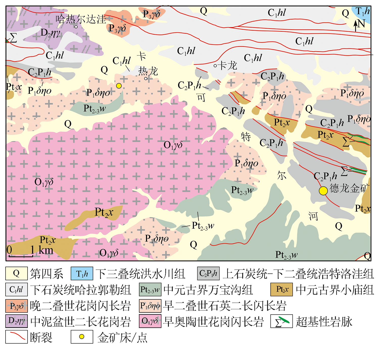
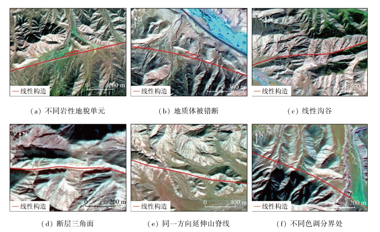
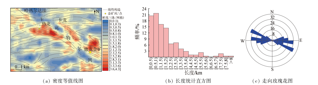
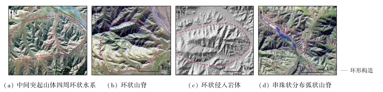
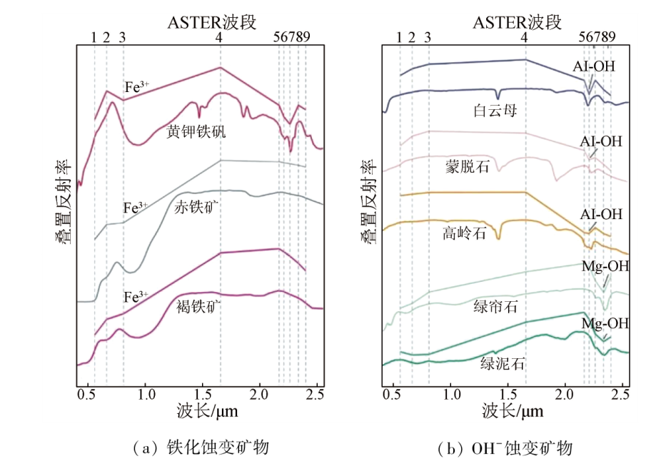
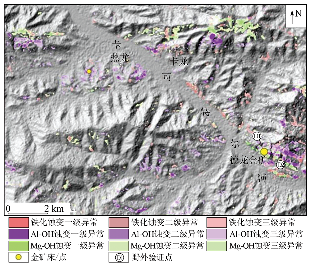
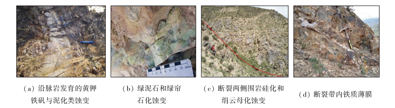
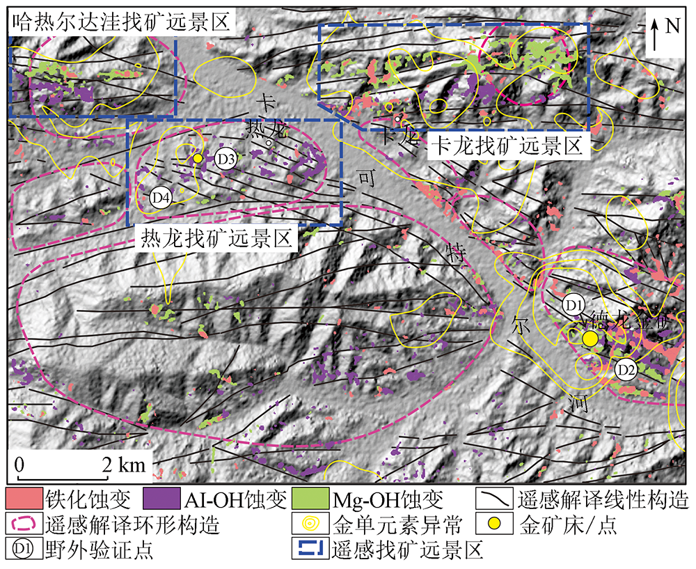
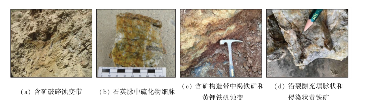
Abstract The Delong area, located in the eastern segment of the Eastern Kunlun gold-polymetallic metallogenic belt in Qinghai, is recognized as an area with significant exploration potential. However, its remote geographical location and rugged terrain pose challenges to large-scale geochemical explorations and conventional geological surveys. Based on ASTER and GF-2 data, this study identified the linear and circular structures by analyzing the color tones, geometric structures, and textures of remote sensing images with varying resolutions. Through the spectral analysis of primary alteration minerals, this study extracted the information on ferrugination, Al-OH, and Mg-OH alterations from visible light to near-infrared bands and short-wave infrared bands of ASTER using the mask + principal component analysis technique. Then, this study established a remote sensing-based prospecting prediction model for gold deposits in the study area by combining geoscience information and field survey results and comprehensively analyzing the association between the tectonic alteration information derived from remote sensing image interpretation and the gold mineralization of the study area. Using the prediction model, this study delineated three prospective areas for mineral exploration. The field verification revealed several new gold ore bodies in the Delong prospective area. The results show that the integration of remote sensing data and GIS technology can effectively identify surface hydrothermal alterations and tectonic spatial structures. The integration can serve as a guide for subsequent prospecting prediction of the study area.
|
| Keywords
GF-2
ASTER
principal component analysis (PCA)
prospecting prediction
Delong are
|
|
|
|
Issue Date: 13 March 2024
|
|
|
| [1] |
Chen J J, Fu L B, Selby D, et al. Multiple episodes of gold mineralization in the East Kunlun Orogen,western Central Orogenic Belt,China:Constraints from Re-Os sulfide geochronology[J]. Ore Geo-logy Reviews, 2020, 123:103587.
|
| [2] |
Yao Y, Hsü K J. Origin of the Kunlun Mountains by arc-arc and arc-continent collisions[J]. Island Arc, 1994, 3(2):75-89.
doi: 10.1111/iar.1994.3.issue-2
url: https://onlinelibrary.wiley.com/toc/14401738/3/2
|
| [3] |
唐洋, 付乐兵, 杨宝荣, 等. 东昆仑东段果洛龙洼脉状金矿床断裂构造控矿规律[J]. 地质科技情报, 2017, 36(2):160-167.
|
| [3] |
Tang Y, Fu L B, Yang B R, et al. Ore controlling regularities of fault in the Guoluolongwa lode gold deposit,east segment of eastern Kunlun orogen[J]. Geological Science and Technology Information, 2017, 36(2):160-167.
|
| [4] |
Zhao X, Fu L B, Wei J H, et al. Generation and structural modification of the giant Kengdenongshe VMS type Au-Ag-Pb-Zn polymetallic deposit in the east Kunlun orogen,East Tethys:Constraints from geology,fluid inclusions,noble gas and stable isotopes[J]. Ore Geology Reviews, 2021, 131:104041.
doi: 10.1016/j.oregeorev.2021.104041
url: https://linkinghub.elsevier.com/retrieve/pii/S0169136821000664
|
| [5] |
张萱颖. 青海省都兰县德龙地区矿床特征及靶区优选[D]. 北京: 中国地质大学(北京), 2016.
|
| [5] |
Zhang X Y. Geological characteristics and target selection of the Delong gold deposit, Dulan County,Qinghai province[D]. Beijing: China University of Geosciences(Beijing), 2016.
|
| [6] |
李文君, 王克铭, 张里斌, 等. 青海省都兰县德龙地区金矿地质特征与找矿标志[J]. 中国锰业, 2019, 37(5):84-86.
|
| [6] |
Li W J, Wang K M, Zhang L B, et al. Geological characteristics and prospecting indicators of gold deposits in Delong area Dulan County,Qinghai Province[J]. China’s Manganese Industry, 2019, 37(5):84-86.
|
| [7] |
周红智, 徐崇文, 张松涛, 等. 青海都兰沟里金矿整装勘查区1∶100 000地质矿产数据集[J]. 中国地质, 2019, 46(s1):93-104.
|
| [7] |
Zhou H Z, Xu C W, Zhang S T, et al. The 1∶100 000 mineralogical dataset of the Gouli gold deposit integrated exploration area in Dulan County,Qinghai Province[J]. Geology in China, 2019, 46(s1):93-104.
|
| [8] |
张萱颖, 王晓云, 秦宝民, 等. 激电中梯及音频大地电磁测深法在青海德龙金矿床的应用[J]. 矿产勘查, 2018, 9(3):470-476.
|
| [8] |
Zhang X Y, Wang X Y, Qin B M, et al. Application of IP intermediate gradient survey and controlled source audio frequency magnetotellurice (CSAMT) in Delong gold deposit,Qinghai[J]. Mineral Exploration, 2018, 9(3):470-476.
|
| [9] |
郭帮杰, 潘蔚, 张闯, 等. 基于遥感技术沙特阿拉伯地区钙结岩型铀矿成矿要素识别及潜力评价[J]. 自然资源遥感, 2022, 34(4):299-306.doi:10.6046/zrzyyg.2021373.
|
| [9] |
Guo B J, Pan W, Zhang C, et al. Remote sensing-based identification and potential evaluation of the mineralization elements of calcrete-hosted uranium deposits in Saudi Arabia[J]. Remote Sensing for Natural Resources, 2022, 34(4):299-306.doi:10.6046/zrzyyg.2021373.
|
| [10] |
李根军, 杨雪松, 张兴, 等. ZY1-02D高光谱数据在地质矿产调查中的应用与分析[J]. 国土资源遥感, 2021, 33(2):134-140.doi:10.6046/gtzyyg.2020190.
|
| [10] |
Li G J, Yang X S, Zhang X, et al. Application and analysis of ZY1-02D hyperspectral data in geological and mineral survey[J]. Remote Sensing for Land and Resources, 2021, 33(2):134-140.doi:10.6046/gtzyyg.2020190.
|
| [11] |
王瑞军, 张春雷, 孙永彬, 等. 高光谱在甘肃红山多金属找矿模型构建中的应用[J]. 国土资源遥感, 2020, 32(3):222-231.doi:10.6046/gtzyyg.2020.03.29.
|
| [11] |
Wang R J, Zhang C L, Sun Y B, et al. Application of hyperspectral spectroscopy to constructing polymetallic prospecting model in Hongshan,Gansu Province[J]. Remote Sensing for Land and Resources, 2020, 32(3):222-231.doi:10.6046/gtzyyg.2020.03.29.
|
| [12] |
刘建宇, 陈玲, 李伟, 等. 基于ASTER数据韧性剪切带型金矿蚀变信息提取方法优化[J]. 国土资源遥感, 2019, 31(1):229-236.doi:10.6046/gtzyyg.2019.01.30.
|
| [12] |
Liu J Y, Chen L, Li W, et al. An improved method for extracting alteration related to the ductile shear zone type gold deposits using ASTER data[J]. Remote Sensing for Land and Resources, 2019, 31(1):229-236.doi:10.6046/gtzyyg.2019.01.30.
|
| [13] |
魏英娟, 刘欢. 北衙金矿床遥感矿化蚀变信息提取及找矿预测[J]. 自然资源遥感, 2021, 33(3):156-163.doi:10.6046/zrzyyg.2020317.
|
| [13] |
Wei Y J, Liu H. Remote sensing-based mineralized alteration information extraction and prospecting prediction of the Beiya gold deposit,Yunnan province[J]. Remote Sensing for Natural Resources, 2021, 33(3):156-163.doi:10.6046/zrzyyg.2020317.
|
| [14] |
付丽华, 张策. 基于高分遥感数据的西藏荣勒地区控矿信息提取[J]. 国土资源遥感, 2020, 32(1):98-105.doi:10.6046/gtzyyg.2020.01.14.
|
| [14] |
Fu L H, Zhang C. Study of ore control information in Rongle area of Tibet based on high resolution remote sensing data[J]. Remote Sensing for Land and Resources, 2020, 32(1):98-105.doi:10.6046/gtzyyg.2020.01.14.
|
| [15] |
王烜, 王海鹏, 王然, 等. 基于GF2号与Landsat8数据融合的遥感图像地质解译——以1∶5万瓦房店市幅为例[J]. 地质论评, 2019, 65(4):918-928.
|
| [15] |
Wang X, Wang H P, Wang R, et al. Geological interpretation of remote sensing images based on data fusion of GF2 and Landsat8:A case study of the Wafangdian 1∶50 000 quadrangle map[J]. Geological Review, 2019, 65(4):918-928.
|
| [16] |
张微, 金谋顺, 张少鹏, 等. 高分遥感卫星数据在东昆仑成矿带找矿预测中的应用[J]. 国土资源遥感, 2016, 28(2):112-119.doi:10.6046/gtzyyg.2016.02.18.
|
| [16] |
Zhang W, Jin M S, Zhang S P, et al. Application of high resolution remote sensing data to ore-prospecting prediction in East Kunlun metallogenic belt[J]. Remote Sensing for Land and Resources, 2016, 28(2):112-119.doi:10.6046/gtzyyg.2016.02.18.
|
| [17] |
Porwal A, González-Álvarez I. Introduction to special issue on geologic remote sensing[J]. Ore Geology Reviews, 2019, 105:216-222.
doi: 10.1016/j.oregeorev.2018.12.001
|
| [18] |
王润生, 甘甫平, 闫柏琨, 等. 高光谱矿物填图技术与应用研究[J]. 国土资源遥感, 2010, 22(1):1-13.doi:10.6046/gtzyyg.2010.01.01.
|
| [18] |
Wang R S, Gan F P, Yan B K, et al. Hyperspectral mineral mapping and its application[J]. Remote Sensing for Land and Resources, 2010, 22(1):1-13.doi:10.6046/gtzyyg.2010.01.01.
|
| [19] |
刘刚. 东昆仑五龙沟金矿围岩蚀变的遥感识别[J]. 国土资源遥感, 2002, 14(4):60-62.doi:10.6046/gtzyyg.2002.04.13.
|
| [19] |
Liu G. Remote sensing extraction of alteration information related to the Wulonggou gold deposit,East Kunlun Mountains[J]. Remote Sensing for Land and Resources, 2002, 14(4):60-62.doi:10.6046/gtzyyg.2002.04.13.
|
| [20] |
张廷斌, 钟康惠, 易桂花, 等. 东昆仑五龙沟金矿集中区遥感地质信息提取与找矿预测[J]. 地质与勘探, 2009, 45(4):444-449.
|
| [20] |
Zhang T B, Zhong K H, Yi G H, et al. The extraction of remote sensing geological information and metallogeneic prediction of gold mineralized concentrate district in Wulonggou,East Kunlun Mountains[J]. Geology and Exploration, 2009, 45(4):444-449.
|
| [21] |
张玉君, 姚佛军. 应用多光谱ASTER数据对ETM遥感异常的定性判别研究-——以东昆仑五龙沟为例[J]. 岩石学报, 2009, 25(4):963-970.
|
| [21] |
Zhang Y J, Yao F J. Application study of multi-spectral ASTER data for determination of ETM remote sensing anomaly property:Taking Wulonggou region of eastern Kunlun Mountain range as example[J]. Acta Petrologica Sinica, 2009, 25(4):963-970.
|
| [22] |
吴浩, 徐元进, 范高晶, 等. 奇异值分解在ETM+遥感蚀变信息提取中的应用——以青海省五龙沟金矿勘查区为例[J]. 地理与地理信息科学, 2016, 32(2):40-45.
|
| [22] |
Wu H, Xu Y J, Fan G J, et al. Using ETM+ data for extraction of alteration information based on singular value decomposition:A case study of Wulonggou gold deposit,Qinghai[J]. Geography and Geo-Information Science, 2016, 32(2):40-45.
|
| [23] |
易桂花, 张廷斌, 倪师军, 等. 五龙沟金矿集中区化探异常与遥感蚀变异常的综合分析[J]. 中国矿业, 2010, 19(12):104-106.
|
| [23] |
Yi G H, Zhang T B, Ni S J, et al. Comprehensive analysis of geochemical anomaly and remote sensing alteration of gold mineralized concentrate district in Wulonggou area[J]. China Mining Magazine, 2010, 19(12):104-106.
|
| [24] |
杨经绥, 许志琴, 马昌前, 等. 复合造山作用和中国中央造山带的科学问题[J]. 中国地质, 2010, 37(1):1-11.
|
| [24] |
Yang J S, Xu Z Q, Ma C Q, et al. Compound orogeny and scientific problems concerning the Central Orogenic Belt of China[J]. Geology in China, 2010, 37(1):1-11.
|
| [25] |
孙攀, 董玉森, 陈伟涛, 等. 高分二号卫星影像融合及质量评价[J]. 国土资源遥感, 2016, 28(4):108-113.doi:10.6046/gtzyyg.2016.04.17.
|
| [25] |
Sun P, Dong Y S, Chen W T, et al. Research on fusion of GF-2 imagery and quality evaluation[J]. Remote Sensing for Land and Resources, 2016, 28(4):108-113.doi:10.6046/gtzyyg.2016.04.17.
|
| [26] |
郝建亭, 杨武年, 李玉霞, 等. 基于FLAASH的多光谱影像大气校正应用研究[J]. 遥感信息, 2008, 23(1):78-81.
|
| [26] |
Hao J T, Yang W N, Li Y X, et al. Atmospheric correction of multispectral imagery ASTER[J]. Remote Sensing Information, 2008, 23(1):78-81.
|
| [27] |
夏清, 杨武年, 赵妮. 青藏大陆北缘盆山耦合带库斯拉甫地区遥感蚀变信息提取[J]. 国土资源遥感, 2014, 26(1):127-131.doi:10.6046/gtzyyg.2014.01.22.
|
| [27] |
Xia Q, Yang W N, Zhao N. Extraction of remote sensing alteration information of Kosrap area in northern basin-mountain coupling zone of Tibetan Plateau[J]. Remote Sensing for Land and Resources, 2014, 26(1):127-131.doi:10.6046/gtzyyg.2014.01.22.
|
| [28] |
徐涵秋, 张铁军. ASTER与Landsat ETM+植被指数的交互比较[J]. 光谱学与光谱分析, 2011, 31(7):1902-1907.
|
| [28] |
Xu H Q, Zhang T J. Cross comparison of ASTER and Landsat ETM+multispectral measurements for NDVI and SAVI vegetation indices[J]. Spectroscopy and Spectral Analysis, 2011, 31(7):1902-1907.
|
| [29] |
Chavez P S, Berlin G L, Sowers L B. Statistical method for selecting Landsat MSS ratios[J]. Journal of Applied Photographic Engineering, 1982, 8(1):23-30.
|
| [30] |
张焜, 李宗仁, 马世斌. 基于ZY-102C星数据的遥感地质解译——以塔吉克斯坦帕米尔地区为例[J]. 国土资源遥感, 2015, 27(3):144-153.doi:10.6046/gtzyyg.2015.03.23.
|
| [30] |
Zhang K, Li Z R, Ma S B. Remote sensing geological interpretation based on ZY-1 02C satellite images:A case study of Pamir area,Tajikistan[J]. Remote Sensing for Land and Resources, 2015, 27(3):144-153.doi:10.6046/gtzyyg.2015.03.23.
|
| [31] |
Chernicoff C J, Richards J P, Zappettini E O. Crustal lineament control on magmatism and mineralization in northwestern Argentina:Geological,geophysical,and remote sensing evidence[J]. Ore Geology Reviews, 2002, 21(3/4):127-155.
doi: 10.1016/S0169-1368(02)00087-2
url: https://linkinghub.elsevier.com/retrieve/pii/S0169136802000872
|
| [32] |
徐俊龙, 温兴平, 余敏, 等. 基于地质统计学原理的会泽铅锌矿遥感线性构造解析[J]. 地质与勘探, 2014, 50(4):763-771.
|
| [32] |
Xu J L, Wen X P, Yu M, et al. An analysis of linear structures in the Huize lead-zinc mine based on remote sensing images using the principle of geostatistics[J]. Geology and Exploration, 2014, 50(4):763-771.
|
| [33] |
张旺生, 杨巍然. 北祁连山西段遥感构造定量分析与金铜矿化关系[J]. 地质科技情报, 1997, 16(s1):66-68.
|
| [33] |
Zhang W S, Yang W R. Quantitative analysis of remote sensing structure and its relation to Au-Cu mineralization in the Western Part of North Qilian Mountains[J]. Bulletin of Geological Science and Technology. 1997, 16(s1):66-68.
|
| [34] |
陈加杰. 东昆仑造山带东端沟里地区构造岩浆演化与金成矿[D]. 武汉: 中国地质大学(武汉), 2018.
|
| [34] |
Chen J J. Paleozoic-Mesozoic tectono-magmatic evolution and gold mineralization in Gouli area,eastend of East Kunlun Orogen[D]. Wuhan: China University of Geoscience (Wuhan), 2018.
|
| [35] |
魏俊浩. 初论成矿场与矿产勘查意义[J]. 地质科技通报, 2020, 39(1):114-129.
|
| [35] |
Wei J H. Preliminary discussion on the theory of ore-forming field and its significant role for mineral exploration[J]. Bulletin of Geological Science and Technology, 2020, 39(1): 114-129.
|
| [36] |
王润生, 熊盛青, 聂洪峰, 等. 遥感地质勘查技术与应用研究[J]. 地质学报, 2011, 85(11):1699-1743.
|
| [36] |
Wang R S, Xiong S Q, Nie H F, et al. Remote sensing technology and its application in geological exploration[J]. Acta Geologica Sinica, 2011, 85(11):1699-1743.
|
| [37] |
刁海, 张达, 狄永军, 等. 基于主成分分析和分形模型的ASTER蚀变异常信息提取[J]. 国土资源遥感, 2011, 23(2):75-80.doi:10.6046/gtzyyg.2011.02.14.
|
| [37] |
Diao H, Zhang D, Di Y J, et al. The extraction of anomalies from ASTER data based on principal component analysis and fractal model[J]. Remote Sensing for Land and Resources, 2011, 23(2):75-80.doi:10.6046/gtzyyg.2011.02.14.
|
|
Viewed |
|
|
|
Full text
|
|
|
|
|
Abstract
|
|
|
|
|
Cited |
|
|
|
|
| |
Shared |
|
|
|
|
| |
Discussed |
|
|
|
|
 2024,
Vol. 36
2024,
Vol. 36