|
|
 |
|

|
|
|
A method for reconstructing hourly 100-m-resolution all-weather land surface temperature |
YAN Jianan1,2( ), CHEN Hong3(), ZHANG Yuze4, WU Hua1,5 ), CHEN Hong3(), ZHANG Yuze4, WU Hua1,5 |
1. State Key Laboratory of Resources and Environment Information System, Institute of Geographic Sciences and Natural Resources Research, Chinese Academy of Sciences, Beijing 100101, China
2. University of Chinese Academy of Sciences, Beijing 101408, China
3. China Aero Geophysical Survey and Remote Sensing Center for Natural Resources, Beijing 100083, China
4. National Engineering Research Center for Transportation Safety and Emergency Informatics, China Transport Telecommunications & Information Center, Beijing 100028, China
5. Jiangsu Center for Collaborative Innovation in Geographical Information Resource Development and Application, Nanjing 210023, China |
|
|
|
|
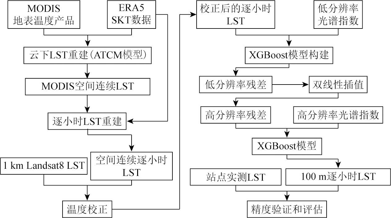
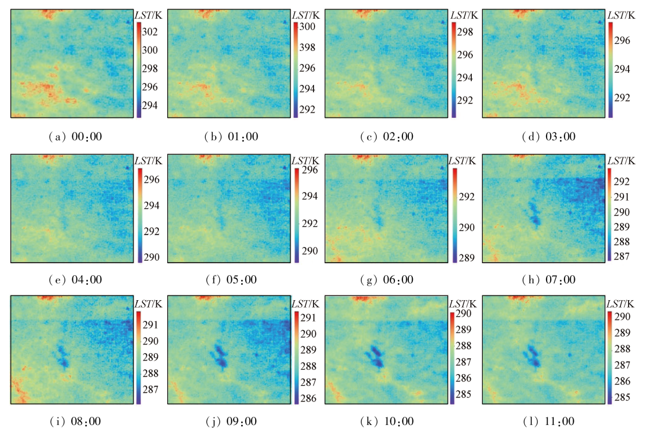
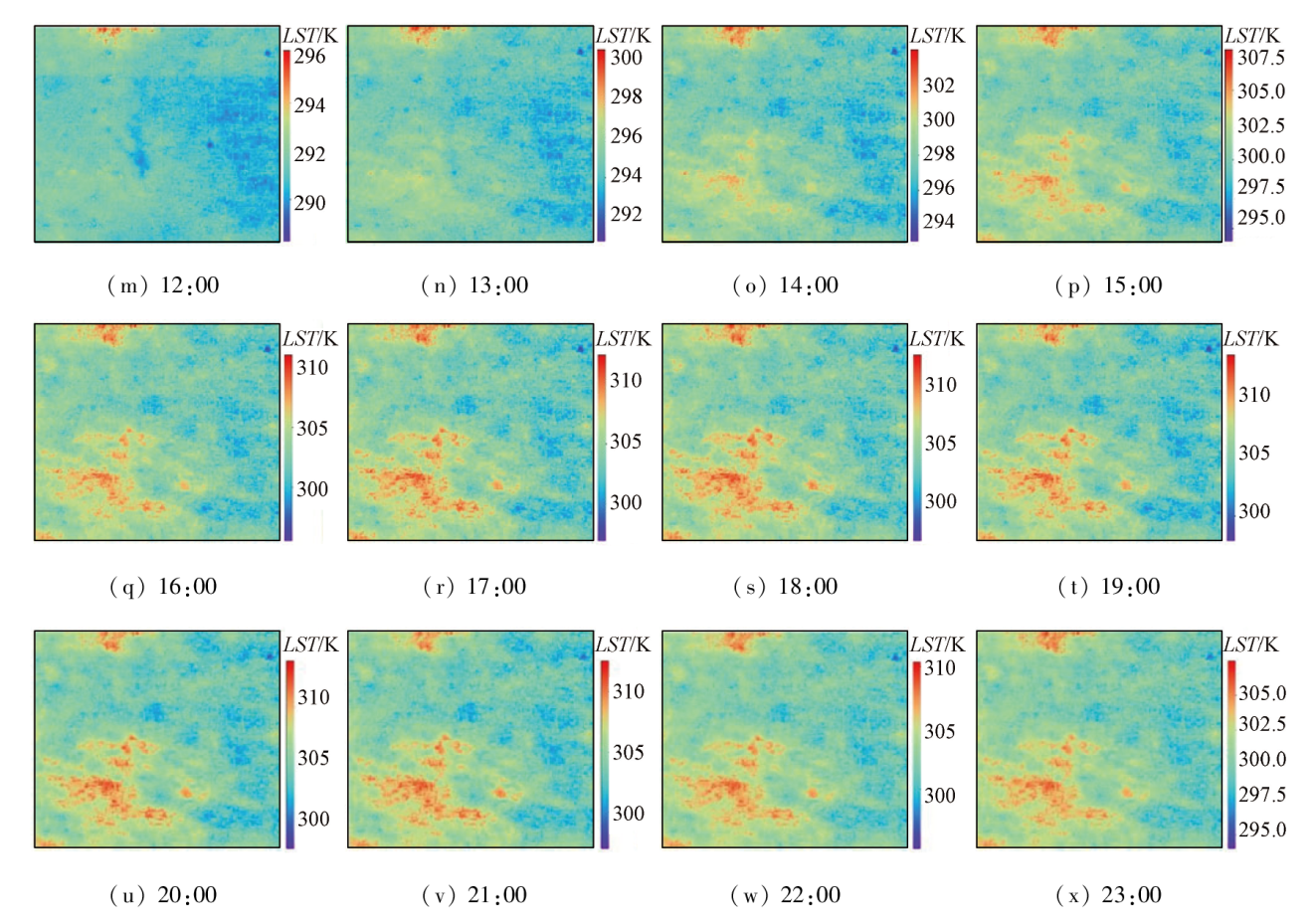
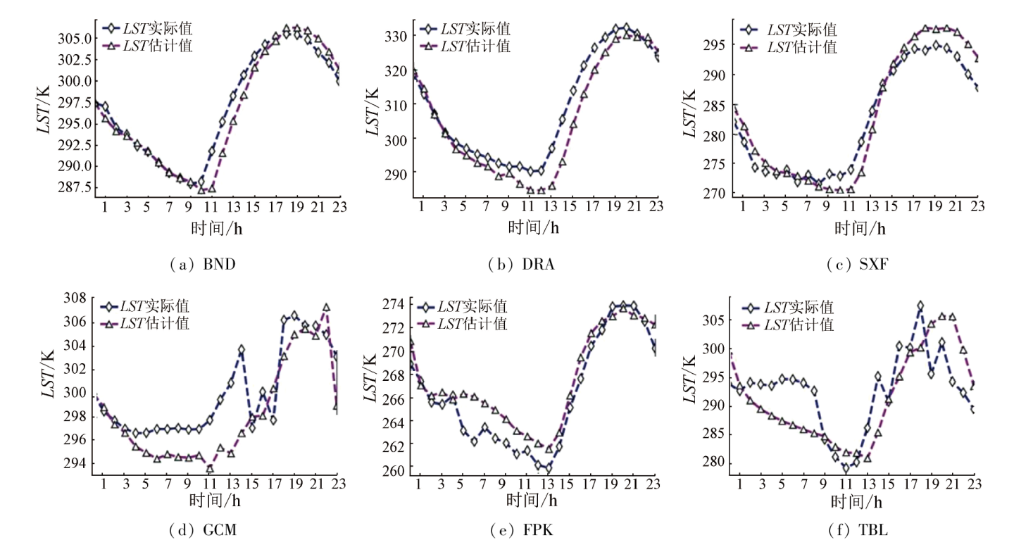
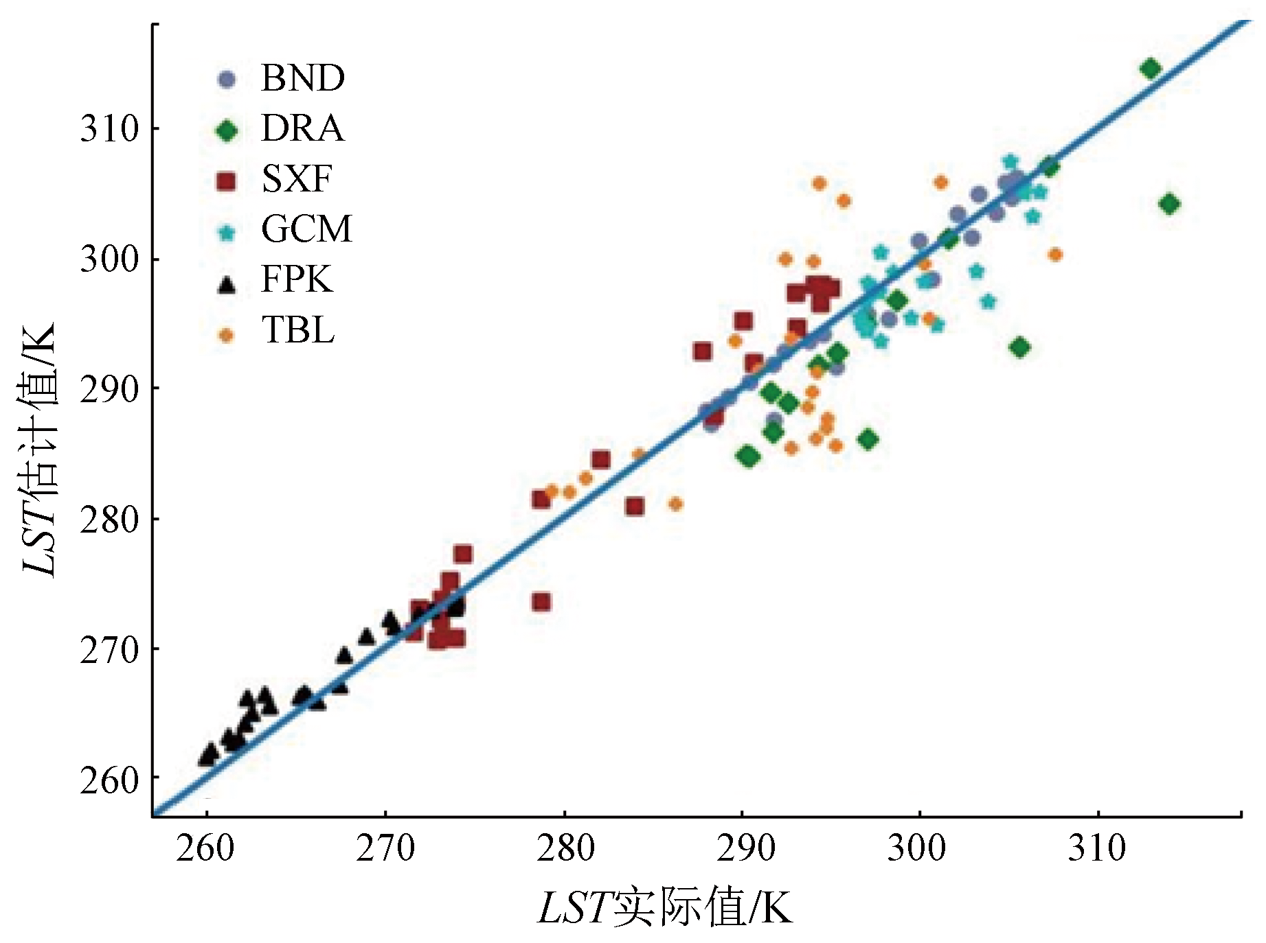
Abstract Land surface temperature (LST) proves to be an important parameter in surface processes on regional and global scales, and its spatiotemporal information can be obtained through thermal infrared remote sensing. However, the constraints of thermal infrared sensors (TIRSs) themselves and the inability of thermal infrared electromagnetic waves to penetrate clouds render it impossible to obtain LST with a high spatiotemporal resolution currently. This study presents a method for reconstructing hourly LST at 100-m resolution in all weathers. This method consists of three main steps: ① cloudy LST at four moments is reconstructed using a moderate resolution imaging spectroradiometer (MODIS) based on the conventional annual temperature cycle (ATC) model; ② the daily variation curve of LST is estimated based on the daily trend in the skin temperature (SKT); ③ with spectral indices as regressors, spatial downscaling is conducted for the hourly LST using Extreme Gradient Boosting (XGBoost). The results show that the proposed reconstruction method can obtain spatiotemporally continuous LST products, improve the spatial resolution of LST, and provide more details. The validation of the hourly 100-m-resolution LST using data from the surface radiation budget network (SURFRAD) developed by the U.S. indicates that the reconstructed hourly LST exhibits roughly the same trend as the measured values of the SURFRAD. The method for reconstructing all-weather hourly LST boasts high accuracy, with R2 of 0.95, a root mean squared error (RMSE) of 3.75 K, and a bias of 0.75 K.
|
| Keywords
LST
MODIS
cloudy LST reconstruction
downscaling
XGBoost
|
|
|
|
Issue Date: 03 September 2024
|
|
|
| [1] |
Anderson M, Norman J, Kustas W, et al. A thermal-based remote sensing technique for routine mapping of land-surface carbon,water and energy fluxes from field to regional scales[J]. Remote Sensing of Environment, 2008, 112(12):4227-4241.
|
| [2] |
Hu L, Sun Y, Collins G, et al. Improved estimates of monthly land surface temperature from MODIS using a diurnal temperature cycle (DTC) model[J]. ISPRS Journal of Photogrammetry and Remote Sensing, 2020, 168:131-140.
|
| [3] |
Voogt J A, Oke T R. Thermal remote sensing of urban climates[J]. Remote Sensing of Environment, 2003, 86(3):370-384.
|
| [4] |
Giglio L, Csiszar I, Restás Á, et al. Active fire detection and characterization with the advanced spaceborne thermal emission and reflection radiometer (ASTER)[J]. Remote Sensing of Environment, 2008, 112(6):3055-3063.
|
| [5] |
Stathopoulou M, Cartalis C. Downscaling AVHRR land surface temperatures for improved surface urban heat island intensity estimation[J]. Remote Sensing of Environment, 2009, 113(12):2592-2605.
|
| [6] |
Anderson M C, Allen R G, Morse A, et al. Use of Landsat thermal imagery in monitoring evapotranspiration and managing water resources[J]. Remote Sensing of Environment, 2012, 122:50-65.
|
| [7] |
Mustafa E K, Abd El-Hamid H T, Tarawally M. Spatial and temporal monitoring of drought based on land surface temperature,Freetown City,Sierra Leone,West Africa[J]. Arabian Journal of Geosciences, 2021, 14(11):1013.
|
| [8] |
Ul Din S, Mak H W L. Retrieval of land-use/land cover change (LUCC) maps and urban expansion dynamics of hyderabad,pakistan via landsat datasets and support vector machine framework[J]. Remote Sensing, 2021, 13(16):3337.
|
| [9] |
Li Z, Tang B, Wu H, et al. Satellite-derived land surface temperature:Current status and perspectives[J]. Remote Sensing of Environment, 2013, 131:14-37.
|
| [10] |
Agam N, Kustas W P, Anderson M C, et al. A vegetation index based technique for spatial sharpening of thermal imagery[J]. Remote Sensing of Environment, 2007, 107(4):545-558.
|
| [11] |
Gallo K, Hale R, Tarpley D, et al. Evaluation of the relationship between air and land surface temperature under clear- and cloudy-sky conditions[J]. Journal of Applied Meteorology and Climatology, 2011, 50(3):767-775.
|
| [12] |
Shwetha H R, Kumar D N. Prediction of high spatio-temporal resolution land surface temperature under cloudy conditions using microwave vegetation index and ANN[J]. ISPRS Journal of Photogrammetry and Remote Sensing, 2016, 117:40-55.
|
| [13] |
Tan W, Wei C, Lu Y, et al. Reconstruction of all-weather daytime and nighttime MODIS Aqua-Terra land surface temperature products using an XGBoost approach[J]. Remote Sensing, 2021, 13(22) :4723.
|
| [14] |
Xu F, Fan J, Yang C, et al. Reconstructing all-weather daytime land surface temperature based on energy balance considering the cloud radiative effect[J]. Atmospheric Research, 2022, 279:106397.
|
| [15] |
Lin C H, Lai K H, Chen Z B, et al. Patch-based information reconstruction of cloud-contaminated multitemporal images[J]. IEEE Transactions on Geoscience and Remote Sensing, 2014, 52(1):163-174.
|
| [16] |
Ozelkan E, Bagis S, Ozelkan E C, et al. Spatial interpolation of climatic variables using land surface temperature and modified inverse distance weighting[J]. International Journal of Remote Sensing, 2015, 36(4):1000-1025.
|
| [17] |
Neteler M. Estimating daily land surface temperatures in mountainous environments by reconstructed MODIS LST data[J]. Remote Sensing, 2010, 2(1):333-351.
|
| [18] |
Mukherjee S, Joshi P K, Garg R D. Regression-kriging technique to downscale satellite-derived land surface temperature in heterogeneous agricultural landscape[J]. IEEE Journal of Selected Topics in Applied Earth Observations and Remote Sensing, 2015, 8(3):1245-1250.
|
| [19] |
Fu P, Xie Y, Weng Q, et al. A physical model-based method for retrieving urban land surface temperatures under cloudy conditions[J]. Remote Sensing of Environment, 2019, 230:111191.
|
| [20] |
Long D, Yan L, Bai L, et al. Generation of MODIS-like land surface temperatures under all-weather conditions based on a data fusion approach[J]. Remote Sensing of Environment, 2020, 246:111863.
|
| [21] |
Wu P, Su Y, Duan S b, et al. A two-step deep learning framework for mapping gapless all-weather land surface temperature using thermal infrared and passive microwave data[J]. Remote Sensing of Environment, 2022, 277:113070.
|
| [22] |
Zhu X, Duan S B, Li Z L, et al. Reconstruction of land surface temperature under cloudy conditions from Landsat8 data using annual temperature cycle model[J]. Remote Sensing of Environment, 2022, 281:113261.
|
| [23] |
Jin M, Dickinson R E. A generalized algorithm for retrieving cloudy sky skin temperature from satellite thermal infrared radiances[J]. Journal of Geophysical Research:Atmospheres, 2000, 105:27037-27047.
|
| [24] |
Zhang X, Chen W, Chen Z, et al. Construction of cloud-free MODIS-like land surface temperatures coupled with a regional weather research and forecasting (WRF) model[J]. Atmospheric Environment, 2022, 283:119190.
|
| [25] |
Duan S B, Li Z L, Leng P. A framework for the retrieval of all-weather land surface temperature at a high spatial resolution from polar-orbiting thermal infrared and passive microwave data[J]. Remote Sensing of Environment, 2017, 195:107-117.
|
| [26] |
Yoo C, Im J, Cho D, et al. Estimation of all-weather 1 km MODIS land surface temperature for humid summer days[J]. Remote Sensing, 2020, 12(9) :1398.
|
| [27] |
Zhang X, Zhou J, Liang S, et al. Estimation of 1-km all-weather remotely sensed land surface temperature based on reconstructed spatial-seamless satellite passive microwave brightness temperature and thermal infrared data[J]. ISPRS Journal of Photogrammetry and Remote Sensing, 2020, 167:321-344.
|
| [28] |
Zou Z, Zhan W, Liu Z, et al. Enhanced modeling of annual temperature cycles with temporally discrete remotely sensed thermal observations[J]. Remote Sensing, 2018, 10(4) :650.
|
| [29] |
Gao F, Masek J, Schwaller M, et al. On the blending of the Landsat and MODIS surface reflectance:Predicting daily Landsat surface reflectance[J]. IEEE Transactions on Geoscience and Remote Sensing, 2006, 44(8):2207-2218.
|
| [30] |
Xia H, Chen Y, Li Y, et al. Combining kernel-driven and fusion-based methods to generate daily high-spatial-resolution land surface temperatures[J]. Remote Sensing of Environment, 2019, 224:259-274.
|
| [31] |
Zhu X, Helmer E H, Gao F, et al. A flexible spatiotemporal method for fusing satellite images with different resolutions[J]. Remote Sensing of Environment, 2016, 172:165-177.
|
| [32] |
Essa W, Verbeiren B, van der Kwast J, et al. Evaluation of the DisTrad thermal sharpening methodology for urban areas[J]. International Journal of Applied Earth Observation and Geoinformation, 2012, 19:163-172.
|
| [33] |
Gao F, Kustas W, Anderson M. A data mining approach for sharpening thermal satellite imagery over land[J]. Remote Sensing, 2012, 4(11):3287-3319.
|
| [34] |
Ghosh A, Joshi P K. Hyperspectral imagery for disaggregation of land surface temperature with selected regression algorithms over different land use land cover scenes[J]. ISPRS Journal of Photogrammetry and Remote Sensing, 2014, 96:76-93.
|
| [35] |
Pan X, Zhu X, Yang Y, et al. Applicability of downscaling land surface temperature by using normalized difference sand index[J]. Scientific Reports, 2018, 8(1):9530.
doi: 10.1038/s41598-018-27905-0
pmid: 29934513
|
| [36] |
Govil H, Guha S, Dey A, et al. Seasonal evaluation of downscaled land surface temperature:A case study in a humid tropical city[J]. Heliyon, 2019, 5(6) :e01923.
|
| [37] |
Hutengs C, Vohland M. Downscaling land surface temperatures at regional scales with random forest regression[J]. Remote Sensing of Environment, 2016, 178:127-141.
|
| [38] |
华俊玮, 祝善友, 张桂欣. 基于随机森林算法的地表温度降尺度研究[J] .国土资源遥感. 2018, 30(1):78-86.doi:10.6046/gtzyyg.2018.01.11.
|
| [38] |
Hua J W, Zhu S Y, Zhang G X. Downscaling land surface temperature based on random forest algorithm[J]. Remote Sensing for Land and Resources, 2018, 30(1):78-86.doi:10.6046/gtzyyg.2018.01.11.
|
| [39] |
李婉, 牛陆, 陈虹, 等. 基于随机森林算法的地表温度鲁棒降尺度方法[J]. 地球信息科学, 2020, 22(8):1666-1678.
|
| [39] |
Li W, Niu L, Chen H, et al. Robust downscaling method of land surface temperature by using random forest algorithm[J]. Journal of Geo-information Science, 2020, 22(8):1666-1678.
|
| [40] |
颜佳楠, 陈虹, 姚光林, 等. 基于XGBoost的LST空间降尺度方法[J] .无线电工程, 2021, 51(12):1508-1516.
|
| [40] |
Yan J N, Chen H, Yao G L, et al. A spatial downscaling method of land surface temperature based on XGBoost algorithm[J]. Radio Engineering, 2021, 51(12):1508-1516.
|
| [41] |
Wang K, Liang S. Evaluation of ASTER and MODIS land surface temperature and emissivity products using long-term surface longwave radiation observations at SURFRAD sites[J]. Remote Sensing of Environment, 2009, 113(7):1556-1565.
|
| [42] |
Wan Z. New refinements and validation of the collection-6 MODIS land-surface temperature/emissivity product[J]. Remote Sensing of Environment, 2014, 140:36-45.
|
| [43] |
Hersbach H, Bell B, Berrisford P, et al. The ERA5 global reanalysis[J]. Quarterly Journal of the Royal Meteorological Society, 2020, 146(730):1999-2049.
|
| [44] |
Zhao Y, Tang Q, Wu T, et al. Effects of soil parameterization on permafrost modeling in the Qinghai-Tibet Plateau:A calibration-constrained analysis[J]. Cold Regions Science and Technology, 2023, 210:103833.
|
| [45] |
Chen T, Guestrin C. XGBoost:A scalable tree boosting system[C]// Proceedings of the 22nd ACM SIGKDD International Conference on Knowledge Discovery and Data Mining,2016:785-794.
|
| [46] |
Pan Z, Lu W, Wang H, et al. Groundwater contaminant source identification based on an ensemble learning search framework associated with an auto XGBoost surrogate[J]. Environmental Modelling and Software, 2023, 159:105588.
|
| [47] |
Ma M, Zhao G, He B, et al. XGBoost-based method for flash flood risk assessment[J]. Journal of Hydrology, 2021, 598:126382.
|
| [48] |
Dong J, Zeng W, Wu L, et al. Enhancing short-term forecasting of daily precipitation using numerical weather prediction bias correcting with XGBoost in different regions of China[J]. Engineering Applications of Artificial Intelligence, 2023, 117:105579.
|
|
Viewed |
|
|
|
Full text
|
|
|
|
|
Abstract
|
|
|
|
|
Cited |
|
|
|
|
| |
Shared |
|
|
|
|
| |
Discussed |
|
|
|
|
 2024,
Vol. 36
2024,
Vol. 36