|
|
|
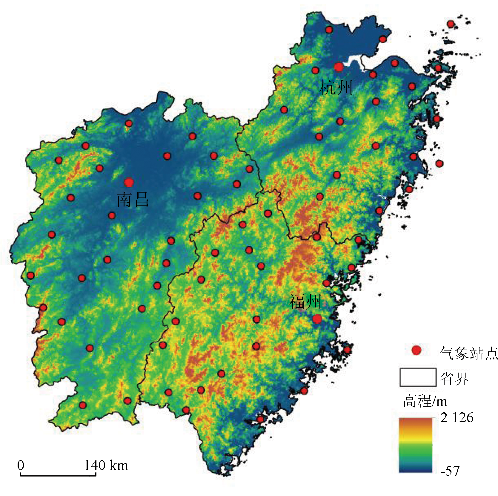
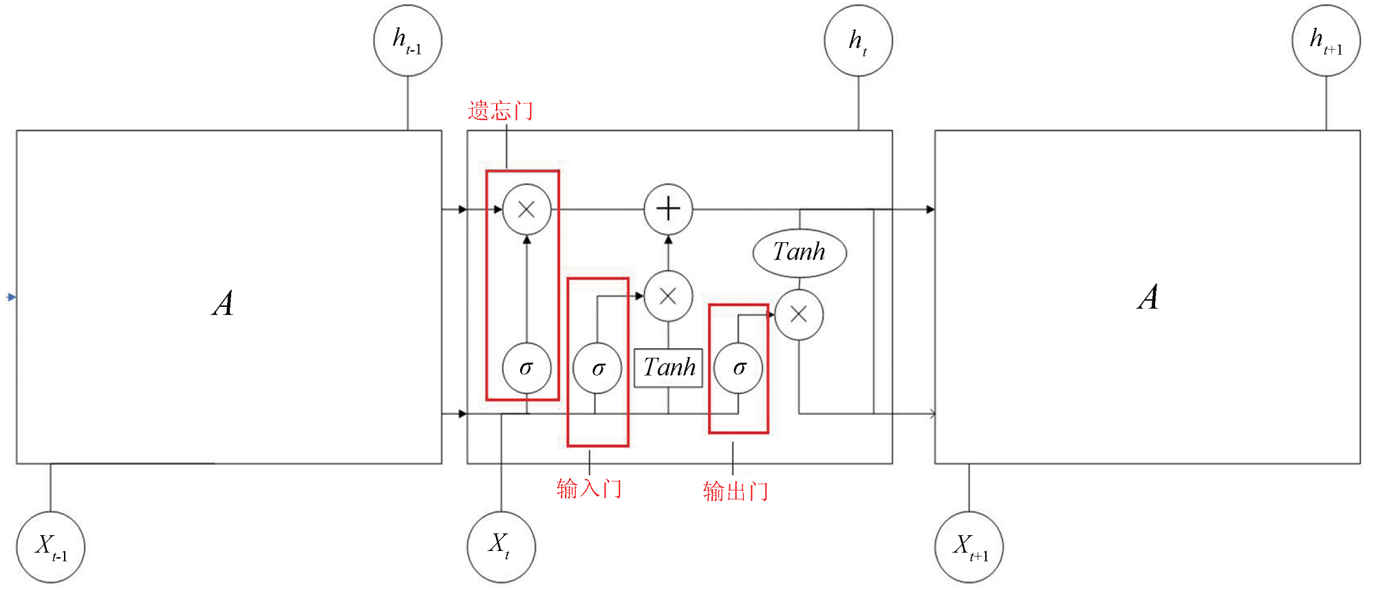
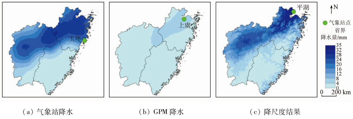
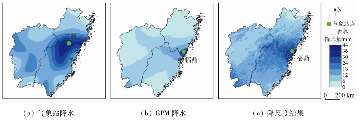
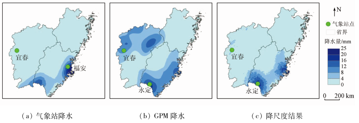
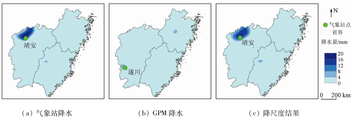
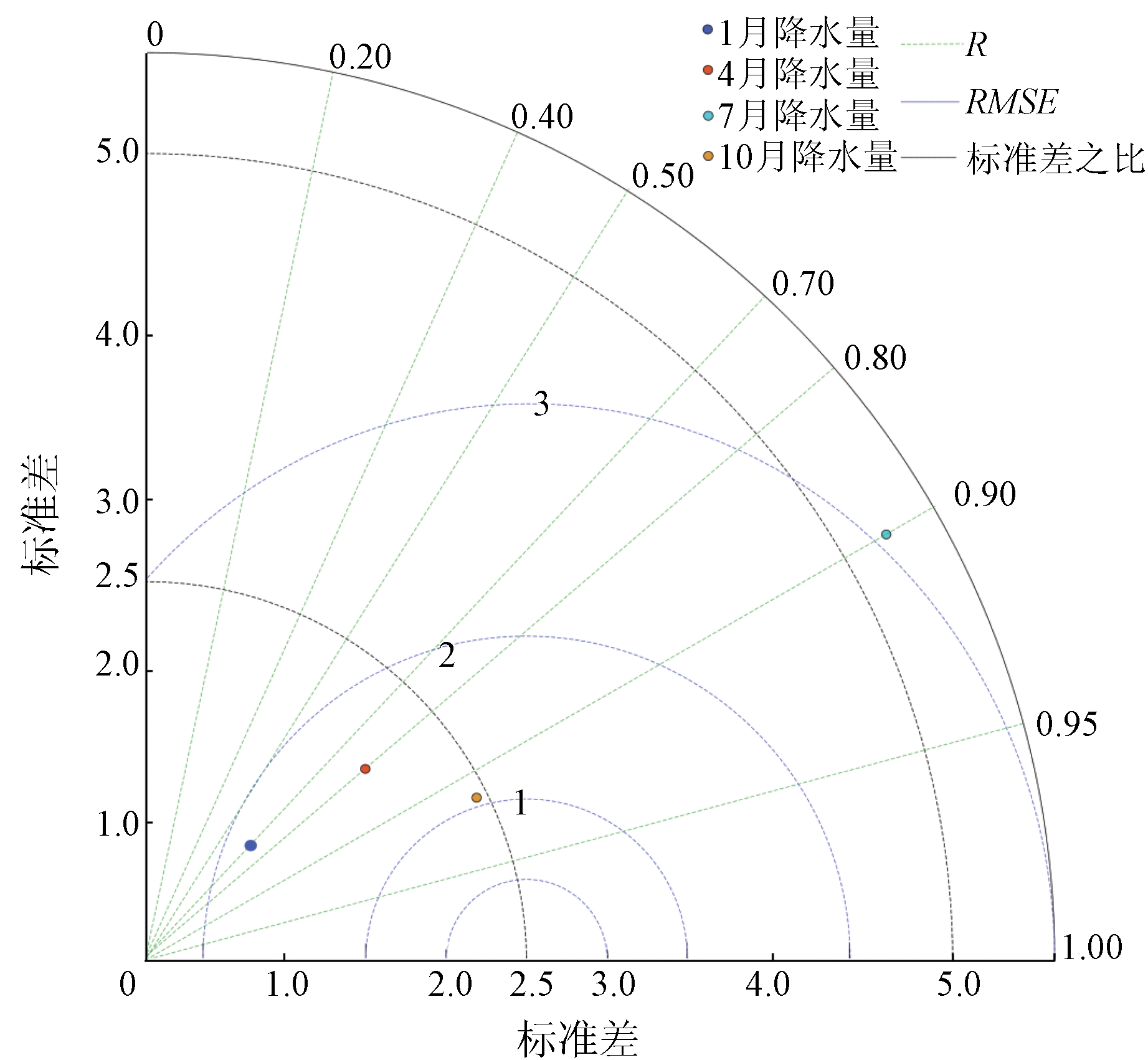
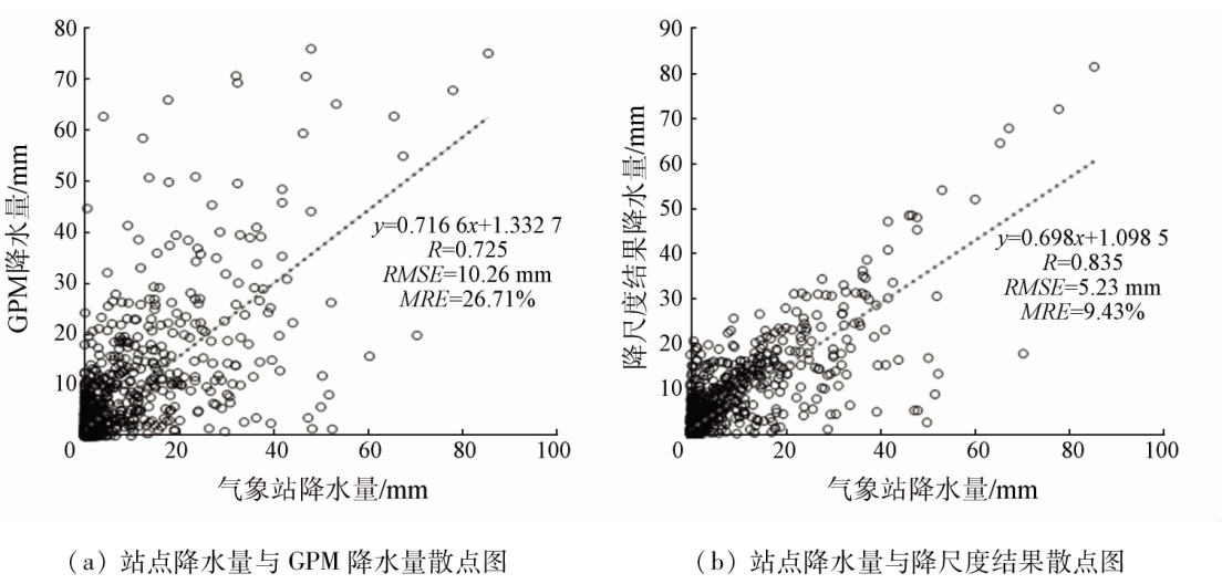
Abstract A timely and accurate assessment of the spatial precipitation distribution holds great significance to the development of the national economy. At present, most remote sensing-based precipitation products improve their accuracy using multiple regression models and physical models rather than deep learning models. This study improved a long short-term memory neural network (LSTM) deep learning model, yielding an optimized LSTM deep learning model. With the Fujian-Zhejiang-Jiangxi area as the study area, this study conducted downscaling for an integrated multi-satellite retrievals for global precipitation measurement (IMERG) product based on the daily precipitation data of 69 meteorological stations from 2015 to 2019 by introducing multiple factors controlling precipitation such as vegetation, slope aspect, slope gradient. Finally, this study assessed the reliability of the optimized model through verifications based on high-density meteorological stations and individual years. The results show that the downscaling results are consistent with the spatio-temporal distribution of precipitation measured at meteorological stations and, thus, can better reflect the spatial distribution of precipitation in the study area than the original IMERG. Furthermore, underestimated and overestimated precipitation data of the study area from the GPM product were corrected. As indicated by the verification based on high-density meteorological stations, the downscaled model yielded correlation coefficients of 0.9 or above for July and October, which were followed by April. The correlation coefficient was the lowest of 0.7 in January. As shown by the verification based on individual year data, the correlation coefficient between the daily precipitation downscaling results and the measurement results in 2020 was above 0.8, with a root mean square error of 5.23 mm and an average relative error of 9.43%. Therefore, the deep learning-based downscaling model enjoys high accuracy on both daily and monthly scales and can be widely applied in the assessment of both spatial and temporal precipitation distributions.
|
| Keywords
Fujian-Zhejiang-Jiangxi
Poyang Lake basin
precipitation
downscaling
deep learning
|
|
|
|
Issue Date: 21 December 2023
|
|
|
| [1] |
Wang Q X, Wang M B, Fan X H, et al. Trends of temperature and precipitation extremes in the Loess Plateau region of China,1961—2010[J]. Theoretical and Applied Climatology, 2017, 129(3):949-963.
doi: 10.1007/s00704-016-1820-z
url: http://link.springer.com/10.1007/s00704-016-1820-z
|
| [2] |
Xu C, Luo Y, Xu Y. Projected changes of precipitation extremes in river basins over China[J]. Quaternary International, 2011, 244(2):149-158.
doi: 10.1016/j.quaint.2011.01.002
url: https://linkinghub.elsevier.com/retrieve/pii/S1040618211000139
|
| [3] |
Yu S, Xia J, Yan Z, et al. Changing spring phenology dates in the Three-Rivers Headwater region of the Tibetan Plateau during 1960—2013[J]. Advances in Atmospheric Sciences, 2018, 35(1):116-126.
doi: 10.1007/s00376-017-6296-y
|
| [4] |
Huang L, Liu J, Shao Q, et al. Changing inland lakes responding to climate warming in Northeastern Tibetan Plateau[J]. Climatic Change, 2011, 109(3):479-502.
doi: 10.1007/s10584-011-0032-x
url: http://link.springer.com/10.1007/s10584-011-0032-x
|
| [5] |
张华龙, 肖柳斯, 陈生, 等. 基于GPM卫星的广东汛期降水日变化特征与评估[J]. 热带气象学报, 2020, 36(3): 335-346.
|
| [5] |
Zhang H L, Xiao L S, Chen S, et al. Characteristics and evaluation of diurnal rainfall variation in rainy seasons in Guangdong based on GPM satellite[J]. Journal of Tropical Meteorology, 2020, 36(3):335-346.
|
| [6] |
Hou A Y, Kakar R K, Neeck S, et al. The global precipitation measurement mission[J]. Bulletin of the American Meteorological Society, 2014, 95(5):701-722.
doi: 10.1175/BAMS-D-13-00164.1
|
| [7] |
Sodunke M A, Ojo J S, Adedayo K D, et al. Performance evaluation of metric measures for converting 30-min GPM rain data to 1-min for microwave applications in Tropical region of Nigeria:A multivariate approach[J]. Advances in Space Research, 2022, 69(8):3117-3129.
doi: 10.1016/j.asr.2022.01.040
url: https://linkinghub.elsevier.com/retrieve/pii/S0273117722000771
|
| [8] |
Lu X, Tang G, Wang X, et al. Correcting GPM IMERG precipitation data over the Tianshan Mountains in China[J]. Journal of Hydrology, 2019, 575:1239-1252.
doi: 10.1016/j.jhydrol.2019.06.019
url: https://linkinghub.elsevier.com/retrieve/pii/S0022169419305682
|
| [9] |
史岚, 何其全, 杨娇, 等. 闽浙赣地区GPM IMERG降水产品降尺度建模与比较分析[J]. 地球信息科学学报, 2019, 21(10): 1642-1652.
doi: 10.12082/dqxxkx.2019.180603
|
| [9] |
Shi L, He Q Q, Yang J, et al. Downscaling modeling of the GPM IMERG precipitation product and comparative analysis in the Fujian-Zhejiang-Jiangxi region[J]. Journal of Geo-Information Science, 2019, 21(10):1642-1652.
|
| [10] |
胡实, 韩建, 占车生, 等. 太行山区遥感卫星反演降雨产品降尺度研究[J]. 地理研究, 2020, 39(7): 1680-1690.
doi: 10.11821/dlyj020190545
|
| [10] |
Hu S, Han J, Zhan C S, et al. Spatial downscaling of remotely sensed precipitation in Taihang Mountains[J]. Geographical Research, 2020, 39 (7):1680-1690.
doi: 10.11821/dlyj020190545
|
| [11] |
Brocca L, Massari C, Pellarin T, et al. River flow prediction in data scarce regions:Soil moisture integrated satellite rainfall products outperform rain gauge observations in West Africa[J]. Scientific Reports, 2020, 10(1):12517.
doi: 10.1038/s41598-020-69343-x
pmid: 32719498
|
| [12] |
Hinton G E, Osindero S, Teh Y W. A fast learning algorithm for deep belief nets[J]. Neural Computation, 2006, 18(7):1527-1554.
doi: 10.1162/neco.2006.18.7.1527
pmid: 16764513
|
| [13] |
Afshin S, Fahmi H, Alizadeh A, et al. Long term rainfall forecasting by integrated artificial neural network-fuzzy logic-wavelet model in Karoon basin[J]. Scientific Research and Essays, 2011, 6(6): 1200-1208.
|
| [14] |
Bonnet S M, Evsukoff A, Morales R C A. Precipitation nowcasting with weather Radar images and deep learning in São Paulo,Brasil[J]. Atmosphere, 2020, 11(11):1157.
doi: 10.3390/atmos11111157
url: https://www.mdpi.com/2073-4433/11/11/1157
|
| [15] |
王慧媛. 基于深度学习的短时定量降水预测研究[D]. 金华: 浙江师范大学, 2020.
|
| [15] |
Wang H Y. Short-term quantitative precipitation prediction based on deep learning[D]. Jinhua: Zhejiang Normal University, 2020.
|
| [16] |
周康辉, 郑永光, 韩雷, 等. 机器学习在强对流监测预报中的应用进展[J]. 气象, 2021, 47(3): 274-289.
|
| [16] |
Zhou K H, Zheng Y G, Han L, et al. Advances in application of machine learning to severe convective weather monitoring and forecasting[J]. Meteorological Monthly, 2021, 47(3):274-289.
|
| [17] |
郭瀚阳, 陈明轩, 韩雷, 等. 基于深度学习的强对流高分辨率临近预报试验[J]. 气象学报, 2019, 77(4): 715-727.
|
| [17] |
Guo H Y, Chen M X, Han L, et al. High resolution nowcasting experiment of severe convections based on deep learning[J]. Acta Meteorologica Sinica, 2019, 77(4):715-727.
|
| [18] |
徐海龙, 乔书波, 林家乐. 利用长短时记忆网络的日长变化预报[J]. 测绘科学技术学报, 2020, 37(5): 474-478.
|
| [18] |
Xu H L, Qiao S B, Lin J L. Prediction of length-of-day variations by long short-term memory network[J]. Journal of Geomatics Science and Technology, 2020, 37 (5):474-478.
|
| [19] |
袁建刚, 李旺, 刘胜男. 基于深度学习构建的全球电离层NmF2模型[J]. 测绘科学技术学报, 2020, 37(1): 15-20.
|
| [19] |
Yuan J G, Li W, liu S N. A global ionospheric NmF2 model developed by deep learning[J]. Journal of Geomatics Science and Technology, 2020, 37(1):15-20.
|
| [20] |
Xiang L, Xiang J, Guan J, et al. A novel reference-based and gradient-guided deep learning model for daily precipitation downscaling[J]. Atmosphere, 2022, 13(4):511.
doi: 10.3390/atmos13040511
url: https://www.mdpi.com/2073-4433/13/4/511
|
| [21] |
吴海平, 黄世存. 基于深度学习的新增建设用地信息提取试验研究——全国土地利用遥感监测工程创新探索[J]. 国土资源遥感, 2019, 31(4):159-166.doi:10.6046/gtzyyg.2019.04.21.
|
| [21] |
Wu H P, Huang S C. Research on new construction land information extraction based on deep learning:Innovation exploration of the national project of land use monitoring via remote sensing[J]. Remote Sensing for Land and Resources, 2019, 31(4):159-166.doi:10.6046/gtzyyg.2019.04.21.
|
| [22] |
徐佳, 袁春琦, 程圆娥, 等. 基于主动深度学习的极化SAR图像分类[J]. 国土资源遥感, 2018, 30(1):72-77.doi:10.6046/gtzyyg.2018.01.10.
|
| [22] |
Xu J, Yuan C Q, Cheng Y E, et al. Active deep learning based polarimetric SAR image classification[J]. Remote Sensing for Land and Resources, 2018, 30(1):72-77.doi:10.6046/gtzyyg.2018.01.10.
|
| [23] |
王永全, 李清泉, 汪驰升, 等. 基于系留无人机的应急测绘技术应用[J]. 国土资源遥感, 2020, 32(1):1-6.doi:10.6046/gtzyyg.2020.01.01.
|
| [23] |
Wang Y Q, Li Q Q, Wang C S, et al. Tethered UAVs-based applications in emergency surveying and mapping[J]. Remote Sensing for Land and Resources, 2020, 32(1):1-6.doi:10.6046/gtzyyg.2020.01.01.
|
| [24] |
蔡祥, 李琦, 罗言, 等. 面向对象结合深度学习方法的矿区地物提取[J]. 国土资源遥感, 2021, 33(1):63-71.doi:10.6046/gtzyyg.2020111.
|
| [24] |
Cai X, Li Q, Luo Y, et al. Surface features extraction of mining area image based on object-oriented and deep-learning method[J]. Remote Sensing for Land and Resources, 2021, 33(1):63-71.doi:10.6046/gtzyyg.2020111.
|
| [25] |
崔林丽, 史军, 杨引明, 等. 中国东部植被NDVI对气温和降水的旬响应特征[J]. 地理学报, 2009, 64(7): 850-860.
|
| [25] |
Cui L L, Shi J, Yang Y M, et al. Ten-day response of vegetation NDVI to the variations of temperature and precipitation in Eastern China[J]. Acta Geographica Sinica, 2009, 64(7):850-860.
doi: 10.11821/xb200907009
|
| [26] |
舒守娟, 王元, 熊安元. 中国区域地理、地形因子对降水分布影响的估算和分析[J]. 地球物理学报, 2007, 50(6): 1703-1712.
|
| [26] |
Shu S J, Wang Y, Xiong A Y. Estimation and analysis for geographic and orographic influences on precipitation distribution in China[J]. Chinese Journal of Geophysics, 2007, 50(6):1703-1712.
|
| [27] |
Hochreiter S, Schmidhuber J. Long short-term memory[J]. Neural Computation, 1997, 9(8):1735-1780.
doi: 10.1162/neco.1997.9.8.1735
pmid: 9377276
|
| [28] |
Yu Y, Si X, Hu C, et al. A review of recurrent neural networks:LSTM cells and network architectures[J]. Neural Computation, 2019, 31(7):1235-1270.
doi: 10.1162/neco_a_01199
url: https://direct.mit.edu/neco/article/31/7/1235-1270/8500
|
| [29] |
金晓龙, 邵华, 张弛, 等. GPM卫星降水数据在天山山区的适用性分析[J]. 自然资源学报, 2016, 31(12): 2074-2085.
doi: 10.11849/zrzyxb.20160057
|
| [29] |
Jin X L, Shao H, Zhang C, et al. The applicability evaluation of three satellite products in Tianshan Mountains[J]. Journal of Natural Resources, 2016, 31(12):2074-2085.
|
| [30] |
Tan J, Petersen W A, Tokay A. A novel approach to identify sources of errors in IMERG for GPM ground validation[J]. Journal of Hydrometeorology, 2016, 17(9):2477-2491.
doi: 10.1175/JHM-D-16-0079.1
url: http://journals.ametsoc.org/doi/10.1175/JHM-D-16-0079.1
|
|
Viewed |
|
|
|
Full text
|
|
|
|
|
Abstract
|
|
|
|
|
Cited |
|
|
|
|
| |
Shared |
|
|
|
|
| |
Discussed |
|
|
|
|
 2023,
Vol. 35
2023,
Vol. 35
 ), SHI Lan(